Iapetus Far-Encounter between March 25 and April 18 2006 |

 Unmanned Spaceflight.com > Outer Solar System > Saturn > Cassini Huygens > Cassini's ongoing mission and raw images
  |
Iapetus Far-Encounter between March 25 and April 18 2006 |
 Mar 14 2006, 01:04 PM Mar 14 2006, 01:04 PM
Post
#1
|
|
 Member  Group: Members Posts: 288 Joined: 28-September 05 From: Orion arm Member No.: 516 |
First of all, again the two existing encounter animations:
Animation 1 Animation 2 Nearest approach:  Resolution about 3,6 km/pxl. And some pre-info about upcoming encounters: 2006 Mar 25 to Apr 18: Apr 11 - 602.412 km; 14-3.6 km/pxl; medium to high phase, southern hemisphere as crescent 2006 Jun 17 to 27: Jun 23 - 1.343.000 km; 14-8.1 km/pxl; medium to low phase, sub-Saturn hemisphere 2006 Sep 08 to 09: Sep 02 - 1.816.000 km; ~20 km/pxl; zero phase (3 to 0.05 deg), sub-Saturn 2006 Nov 26: 1.997.000 km; 12 km/pxl; very low phase, sub-Saturn 2007 Feb 12 to 15: Feb 14 - 2.249.000 km; ~14 km/pxl; sub-Saturn; very low phase and eclipse 2007 Apr 14: 2.256.000 km 2007 Jun 22: 1.817.000 km; ~14 km/pxl; med. phase, trailing side 2007 Sep 03 to 09: 8.6-0.7 km/pxl; very high phase, western Cassini Regio 2007 Sep 10: 480-10-540 m/pxl; targeted flyby, trailing side 2007 Sep 11 to 17: 0.7-7.1 km/pxl; low phase (~33 deg) trailing side 2007 Sep 27: 15 km/pxl, low phase sub-Saturn+trailing side 2007 Nov 26: 1.371.000 km; 8.2 km/pxl; very high phase, north pole, possibly graylight 2008 Feb 13: 2.045.000 km; 14 km/pxl; high phase, north pole, possibly graylight Days around Sep 10 belong to the targeted fly-by in about 1000 km distance, others will only be some OPNAVs. Bye. |
 |
 
|
|
Mar 17 2006, 10:28 AM
Post
#2
|
||
|
Member Group: Members Posts: 288 Joined: 28-September 05 From: Orion arm Member No.: 516 |
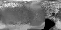
QUOTE (TritonAntares @ Mar 14 2006, 02:04 PM)  I've forgotten a third one: Animation 3 Not so nice concerning the drawn textures, but showing dates and distance data. I've tried to create an additional one with 'Celestia', but I came in trouble with zooming in from Cassini to Iapetus.   Also I did a mistake in using Steve Albers latest map. It's centered on 0°, not on 180° as 'Celestia' wants. So I was quite surprised in seeing the equatorial ridge with its white mountains in prime focus at end of this month...   Is anyone able to convert it into the 180° seight? 1024 x 512 pixels would be sufficient. Alternativly is this map from December:
'Terra incognita' is shown in black... but not so nice as Steves' map. Thx and Bye. |
|
|
|
|
|
|
Mar 17 2006, 01:16 PM
Post
#3
|
||
 Member Group: Members Posts: 159 Joined: 4-March 06 Member No.: 694 |
QUOTE (TritonAntares @ Mar 17 2006, 07:58 PM) I've forgotten a third one: Animation 3 Not so nice concerning the drawn textures, but showing dates and distance data. I've tried to create an additional one with 'Celestia', but I came in trouble with zooming in from Cassini to Iapetus. Also I did a mistake in using Steve Albers latest map. It's centered on 0°, not on 180° as 'Celestia' wants. So I was quite surprised in seeing the equatorial ridge with its white mountains in prime focus at end of this month... Is anyone able to convert it into the 180° seight? 1024 x 512 pixels would be sufficient. Alternativly is this map from December:
'Terra incognita' is shown in black... but not so nice as Steves' map. Thx and Bye. I (out of interest as "Celestia" is referenced here alot), decided to download it. I was not happy with the textures they used for Saturn's moons, so I decided to use Steve Albers maps. And I can get them to work. Here's how. Copy his maps to the "textures --> hires" folder and remove anything after the body's name on the file name. ie "Tethys_www_cyl_rgb" to just "Tethys". Do the same for all the other "Hires" textures. When you load Celestia, choose "Hires" mode and select the maps you have just loaded. And to solve the problem with the maps being centered at 180W reather than 0W, just do a mental calculation to adjust for the problem. ie To have the "The Great White Splat" (12S, 111W) centered on a Rhea Map, select -12 for latitide and 69 for longitude. 69 = -111 (=111W longitude) + 180 Another example "Tirawa" centered Rhea, Latitude = 34.8 (34.8N) Longitude = 28 (-152 + 180) [-152 = 152W] Again using Rhea, "Evil Twin" (10N, 180W) would be imput as +10 latitude and 0 longitude. I have collected a wonderful collection of Saturn's moons and and a variety of views. I have got polar views (centered on both north and south poles) for all of Saturn's moons that I have a good map for (provided by Steve Albers of course!) Of course, the pole centered maps need no adjustment. ie Dione centered 90N and 0W is simply entered unadjusted. 90 for latitude and any input longitude. I hope this helps you. -------------------- I call heaven and earth to witness against you this day, that I have set before thee life and death, the blessing and the curse; therefore choose life, that thou mayest live, thou and thy seed.
- Opening line from episode 13 of "Cosmos" |
|
|
|
|
|
|
Mar 17 2006, 07:24 PM
Post
#4
|
|
 Senior Member Group: Members Posts: 1624 Joined: 5-March 05 From: Boulder, CO Member No.: 184 |
Hi all,
It's true I use a map convention that's 180 degrees offset from Celestia. I actually routinely port my map updates into Celestia. To do this I (in a Linux environment) run the 'convert' utility with a "roll" option to offset the map. There may also be a way to make a Celestia animation that can be posted on the web, though it may be a bit tedious. Here are a couple of still images: http://laps.noaa.gov/albers/sos/saturn/iap...tus_apr06_1.jpg http://laps.noaa.gov/albers/sos/saturn/iap...tus_apr06_2.jpg -------------------- Steve [ my home page and planetary maps page ]
|
|
|
|
|
Mar 18 2006, 12:43 PM
Post
#5
|
|
|
Member Group: Members Posts: 159 Joined: 4-March 06 Member No.: 694 |
QUOTE (scalbers @ Mar 18 2006, 04:54 AM) Hi all, It's true I use a map convention that's 180 degrees offset from Celestia. I actually routinely port my map updates into Celestia. To do this I (in a Linux environment) run the 'convert' utility with a "roll" option to offset the map. There may also be a way to make a Celestia animation that can be posted on the web, though it may be a bit tedious. Here are a couple of still images: http://laps.noaa.gov/albers/sos/saturn/iap...tus_apr06_1.jpg http://laps.noaa.gov/albers/sos/saturn/iap...tus_apr06_2.jpg Is there a "roll" option for those who use Celestia only on Microsoft Windows? Can you write a script in Celestia for Windows to compersate for it? -------------------- I call heaven and earth to witness against you this day, that I have set before thee life and death, the blessing and the curse; therefore choose life, that thou mayest live, thou and thy seed.
- Opening line from episode 13 of "Cosmos" |
|
|
|
|
Mar 18 2006, 02:29 PM
Post
#6
|
|
 Dublin Correspondent Group: Admin Posts: 1799 Joined: 28-March 05 From: Celbridge, Ireland Member No.: 220 |
QUOTE (angel1801 @ Mar 18 2006, 12:43 PM) Is there a "roll" option for those who use Celestia only on Microsoft Windows? Can you write a script in Celestia for Windows to compersate for it? I don't think celestia can do this itself but you can also do this with any graphics editor that can load the files - just carefully split it in two and rejoin by hand. I have a short Perl GD script that I can post that does it but you'd need Perl with the GD module installed for it to be of any use to you. |
|
|
|
|
Mar 18 2006, 02:54 PM
Post
#7
|
|
|
Senior Member Group: Members Posts: 1624 Joined: 5-March 05 From: Boulder, CO Member No.: 184 |
Angel1801,
It turns out that the 'convert' utility is independent of Celestia, so I simply run this prior to copying the file into my Celestia directory. Perhaps there's a similar utility available in the Windows environment, within Photoshop or something like that? Another option is that I might be able to mirror some of my Celestia map versions to a web-accessable directory. Hopefully the disk space would be reasonable, though if that were an issue I could always run my 2-week purger on it (relative to when I update a given image). I'll think about this some more over the next few days. -------------------- Steve [ my home page and planetary maps page ]
|
|
|
|
|
Mar 18 2006, 06:27 PM
Post
#8
|
|
|
Solar System Cartographer Group: Members Posts: 10145 Joined: 5-April 05 From: Canada Member No.: 227 |
If you need to switch between maps centred at 0 and 180 longitude, the process is trivial in any image editing software like Photoshop. I would simply select the whole map, copy it and paste it over itself twice. One copy I push out half-way to the left, one half-way to the right, then zoom in and make sure they are exactly lined up with each other and with the middle column of pixels. Flatten and save.
Phil -------------------- ... because the Solar System ain't gonna map itself.
Also to be found posting similar content on https://mastodon.social/@PhilStooke NOTE: everything created by me which I post on UMSF is considered to be in the public domain (NOT CC, public domain) |
|
|
|
|
Mar 19 2006, 04:51 AM
Post
#9
|
|
 Member Group: Members Posts: 345 Joined: 2-May 05 Member No.: 372 |
QUOTE (Phil Stooke @ Mar 18 2006, 01:27 PM) If you need to switch between maps centred at 0 and 180 longitude, the process is trivial in any image editing software like Photoshop. I would simply select the whole map, copy it and paste it over itself twice. One copy I push out half-way to the left, one half-way to the right, then zoom in and make sure they are exactly lined up with each other and with the middle column of pixels. Flatten and save. Phil You can also use the "offset" filter. Just set it to offset it 1/2 the pixel width of the image to the right. (I hope that made sense. I'm a bit tired.) |
|
|
|
|
Mar 19 2006, 12:24 PM
Post
#10
|
|
|
Senior Member Group: Members Posts: 1870 Joined: 20-February 05 Member No.: 174 |
I flipped the meridians in an Iapetus map a while back in photoshop by using the "Image / Canvas Size" command: I reduce the image by half horizontally, cropping the right side and saving the file as "left". I reload the image and then repeat the process, cropping the left side, saving it (for safety) as "right". I re-size the canvas to enlarge the right, open select and copy the "left" image and paste it in the blank "right" area. Probably need to "flatten" the composite image.
I've never figured out how to use layers and stuff worth a damn. Lazy. |
|
|
|
|
Mar 19 2006, 06:59 PM
Post
#11
|
||
|
Member Group: Members Posts: 288 Joined: 28-September 05 From: Orion arm Member No.: 516 |
Many thanks for the advices on converting the Iapetus-map from 0° to 180° center.
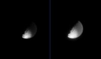
I will try when time allows... Back to Iapetus... ...I found these two 'old' Cassini images back from July 19, 2004:
Distance: ~ 2.9 Mio. km Resolution: 17 km/pxl A first hint on what we'll see in the upcoming far-encounter. Visible is the bright southern rim of the big bassin in eastern CR and the polar region with a large amount of craters below. Actually what is the dark curved structure parallel to the terminator? The eastern rim of another big bassin? There also seems to be a greater structure - possibly a crater - left to the terminator south of this dark bow. Bye. |
|
|
|
|
|
|
Mar 20 2006, 08:31 PM
Post
#12
|
|
|
Senior Member Group: Members Posts: 1624 Joined: 5-March 05 From: Boulder, CO Member No.: 184 |
Interesting images from back in 2004. I'll have to see whether they add any details beyond what I have in the map.
I have also placed some Celestia compatable versions of the Iapetus map on the web at this URL: http://laps.noaa.gov/albers/sos/celestia -------------------- Steve [ my home page and planetary maps page ]
|
|
|
|
|
Mar 20 2006, 11:03 PM
Post
#13
|
|
|
Member Group: Members Posts: 288 Joined: 28-September 05 From: Orion arm Member No.: 516 |
QUOTE (um3k @ Mar 19 2006, 05:51 AM) You can also use the "offset" filter. Just set it to offset it 1/2 the pixel width of the image to the right. I tried this... and easy going! Here are 3 animations for the upcoming far-encounter using this texture: Mar 25 to 31:  iapetus_a.avi.html ( 215.5K )
Number of downloads: 1608
iapetus_a.avi.html ( 215.5K )
Number of downloads: 1608Apr 01 to 12:
iapetus_b.avi.html ( 425K )
Number of downloads: 1315Apr 12 to 18:
iapetus_c.avi.html ( 272K )
Number of downloads: 1320Just remove *.html and run the avi-files. I prefer running them on a DIVX-player. Bye. |
|
|
|
|
Mar 22 2006, 09:27 PM
Post
#14
|
||
 Interplanetary Dumpster Diver Group: Admin Posts: 4404 Joined: 17-February 04 From: Powell, TN Member No.: 33 |
QUOTE (TritonAntares @ Mar 19 2006, 06:59 PM) Many thanks for the advices on converting the Iapetus-map from 0° to 180° center. I will try when time allows... Back to Iapetus... ...I found these two 'old' Cassini images back from July 19, 2004:
Distance: ~ 2.9 Mio. km Resolution: 17 km/pxl Yes...that is a sequence from slightly farther out than the one I used to make this super-res view I posted a while back. 
-------------------- |
|
|
|
|
|
|
Mar 23 2006, 10:33 AM
Post
#15
|
|
|
Member Group: Members Posts: 288 Joined: 28-September 05 From: Orion arm Member No.: 516 |
The first Iapetus image of the upcoming far-encounter has been released by NASA/JPL:
Here an enlarged part: 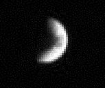 Date: March 16, 2006 Distance: 5.247.271 km (!) Filters: CL1 & CL2 Enlargement: 3x Don't know why they took it, probably an OPNAV. Maybe they just wanted to know if this strange moon is still there... ... it is.  Bye. |
|
|
|
|

|
Lo-Fi Version | Time is now: 16th April 2024 - 09:18 AM |
|
RULES AND GUIDELINES Please read the Forum Rules and Guidelines before posting. IMAGE COPYRIGHT |
OPINIONS AND MODERATION Opinions expressed on UnmannedSpaceflight.com are those of the individual posters and do not necessarily reflect the opinions of UnmannedSpaceflight.com or The Planetary Society. The all-volunteer UnmannedSpaceflight.com moderation team is wholly independent of The Planetary Society. The Planetary Society has no influence over decisions made by the UnmannedSpaceflight.com moderators. |
SUPPORT THE FORUM Unmannedspaceflight.com is funded by the Planetary Society. Please consider supporting our work and many other projects by donating to the Society or becoming a member. |
|