SMART-1 impact, September 2006 |

  |
SMART-1 impact, September 2006 |
 Sep 3 2006, 05:55 PM Sep 3 2006, 05:55 PM
Post
#76
|
|
|
Founder  Group: Chairman Posts: 14434 Joined: 8-February 04 Member No.: 1 |
The crater is expected to be 3 x 10m..... you're not going to see if from the ground. You're not going to see if with Hubble. You're not going to see it until LRO starts mapping at 50cm/pixel in a few years time.
Doug |
 |
 
|
|
Sep 3 2006, 06:07 PM
Post
#77
|
|
|
Junior Member Group: Members Posts: 81 Joined: 19-April 05 Member No.: 256 |
True, the actual crater may not be visible, but the ejecta may change the albedo for a much broader area on the order of hundreds of square meters. But even this may not show up with a wide angle view. I look
forward to some high res pictures of the area. |
|
|
|
|
Sep 3 2006, 06:41 PM
Post
#78
|
||
|
Solar System Cartographer Group: Members Posts: 10226 Joined: 5-April 05 From: Canada Member No.: 227 |
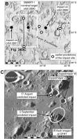
The Apollo 14 LM ascent stage impacted in a mare area west of the landing site. Its impact crater was not seen, but its ejecta was identified by Ewen Whitaker (Apollo 16 Preliminary Science Report). (just to show that the crater itself need not be visible).
Phil A is Apollo 12 image AS12-56-8439, showing the location of B. B is part of Apollo 16 metric camera frame 2508 rectified from its original oblique geometry.
-------------------- ... because the Solar System ain't gonna map itself.
Also to be found posting similar content on https://mastodon.social/@PhilStooke Maps for download (free PDF: https://upload.wikimedia.org/wikipedia/comm...Cartography.pdf NOTE: everything created by me which I post on UMSF is considered to be in the public domain (NOT CC, public domain) |
|
|
|
|
|
|
Sep 3 2006, 06:53 PM
Post
#79
|
||
|
Senior Member Group: Members Posts: 1636 Joined: 9-May 05 From: Lima, Peru Member No.: 385 |
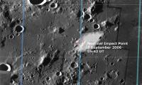
Approximate impact zone:
The impact region lies about two-thirds down, directly above the small gap in the mosaic, just south-east of the small crater Palmieri A in the direction of crater Doppelmayer W ESA estimates that impact occurred at 46.2º West, 34.4º South. I have enclosed a pinpoint impact zone:
Rodolfo |
|
|
|
|
|
|
Sep 3 2006, 07:05 PM
Post
#80
|
|
|
Junior Member Group: Members Posts: 81 Joined: 19-April 05 Member No.: 256 |
From Space.com article.
"Dust and other material ejected off the Moon were expected to possibly be visible to observers with big telescopes back here on Earth." |
|
|
|
|
Sep 3 2006, 07:28 PM
Post
#81
|
|
|
Member Group: Members Posts: 688 Joined: 20-April 05 From: Sweden Member No.: 273 |
QUOTE (garybeau @ Sep 3 2006, 09:05 PM)  From Space.com article. "Dust and other material ejected off the Moon were expected to possibly be visible to observers with big telescopes back here on Earth." You'd have to be very fast. Dust is ballistic on the Moon. tty |
|
|
|
|
Sep 4 2006, 02:21 AM
Post
#82
|
||
|
Solar System Cartographer Group: Members Posts: 10226 Joined: 5-April 05 From: Canada Member No.: 227 |
It's not easy to compare the CFHT image of the flash with the AMIE map, but using the Consolidated Lunar Atlas as an intermediate step, I think this is the location of the flash:
Almost exactly where it was expected, but maybe slightly east of the expected groundtrack. Of course, the observers will do better, but it's interesting to try. Phil -------------------- ... because the Solar System ain't gonna map itself.
Also to be found posting similar content on https://mastodon.social/@PhilStooke Maps for download (free PDF: https://upload.wikimedia.org/wikipedia/comm...Cartography.pdf NOTE: everything created by me which I post on UMSF is considered to be in the public domain (NOT CC, public domain) |
|
|
|
|
|
|
Sep 4 2006, 03:23 PM
Post
#83
|
|
|
Rover Driver Group: Members Posts: 1015 Joined: 4-March 04 Member No.: 47 |
|
|
|
|
|
Sep 4 2006, 07:42 PM
Post
#84
|
||
|
Solar System Cartographer Group: Members Posts: 10226 Joined: 5-April 05 From: Canada Member No.: 227 |
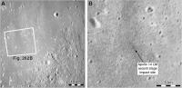
This is my current SMART-1 map, as I understand it now, or think I do. The last item to be plugged into my book except for the foreword, which is now being written.
There's a bit of confusion sometimes between periapsis and impact points, but I think I have it sorted out in the top map - B -. White dots are pre-August impact predictions, black dots are August 17 predictions. In the lower image - C -, plotted on an AMIE mosaic (original provided by Bernard Foing with his permission to use it), I show the August 17 and September 2 predictions and what i think is the location of the IR flash seen at CFHT. Phil
Attached thumbnail(s)
-------------------- ... because the Solar System ain't gonna map itself.
Also to be found posting similar content on https://mastodon.social/@PhilStooke Maps for download (free PDF: https://upload.wikimedia.org/wikipedia/comm...Cartography.pdf NOTE: everything created by me which I post on UMSF is considered to be in the public domain (NOT CC, public domain) |
|
|
|
|
|
|
Sep 4 2006, 08:00 PM
Post
#85
|
|
|
Rover Driver Group: Members Posts: 1015 Joined: 4-March 04 Member No.: 47 |
Fig 363? I am looking forward to your book! It must be well illustrated

|
|
|
|
|
Sep 5 2006, 02:11 PM
Post
#86
|
||
|
Solar System Cartographer Group: Members Posts: 10226 Joined: 5-April 05 From: Canada Member No.: 227 |
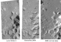
Here is a side by side comparison of an area immediately to the west of the SMART-1 impact point (west of it because the Clementine image doesn't cross the impact site itself).
I'm comparing Lunar Orbiter 4 - the new USGS digital version - with Clementine long-wavelength infrared (LWIR) and AMIE. Warning - this is not a fair comparison for AMIE because it's not raw data. This is just cropped out of the big mosaic of the landing area recently posted. This shows LO4 and Clem at full resolution. The AMIE image is enlarged to match the scale, hence its fuzziness. It is possible that raw AMIE images would equal the resolution of the other two, or get fairly close, near the periapsis latitude. A few other points can be made - the lighting is reversed from Lunar Orbiter, so areas lost in shadow in Orbiter will be seen in AMIE and vice versa - especially important near the poles. And Orbiter coverage of the farside is inferior to this nearside area, so AMIE will at least equal it in many areas. And the Clem LWIR is only available in narrow strips. So we benefit most by having access to all three types of image. AMIE apparently took 20,000 images. When they are released - and especially if good global mosaics are constructed - they will be a very useful addition to lunar databases. And let's not forget that, although several other orbiters are planned, we don't know how many will actually fly successfully. Phil
-------------------- ... because the Solar System ain't gonna map itself.
Also to be found posting similar content on https://mastodon.social/@PhilStooke Maps for download (free PDF: https://upload.wikimedia.org/wikipedia/comm...Cartography.pdf NOTE: everything created by me which I post on UMSF is considered to be in the public domain (NOT CC, public domain) |
|
|
|
|
|
|
Sep 5 2006, 03:44 PM
Post
#87
|
|
|
Senior Member Group: Members Posts: 1636 Joined: 9-May 05 From: Lima, Peru Member No.: 385 |
It is evident that Clementine LWIR has better pictures than Lunar Orbiter 4 and the ones of AMIES looks fuzzier due to the stretch
The morphology of Lunar surface has made me to be inquietant. Its tendency of forming the surface does not agree to others places such as Earth and Mars in which they surface are constantly eroded by others process. Rodolfo P.D. |
|
|
|
|
Sep 5 2006, 03:48 PM
Post
#88
|
|
|
Founder Group: Chairman Posts: 14434 Joined: 8-February 04 Member No.: 1 |
QUOTE (RNeuhaus @ Sep 5 2006, 04:44 PM) due to the scratch process Scratch process? Doug |
|
|
|
|
Sep 5 2006, 03:58 PM
Post
#89
|
|
|
Senior Member Group: Members Posts: 1636 Joined: 9-May 05 From: Lima, Peru Member No.: 385 |
QUOTE (djellison @ Sep 5 2006, 10:48 AM) Scratch process? Doug Already corrected --> Stretch Thanks, Rodolfo |
|
|
|
|
Sep 5 2006, 03:59 PM
Post
#90
|
|
|
Founder Group: Chairman Posts: 14434 Joined: 8-February 04 Member No.: 1 |
Well - I'll still ask the same question - why do the images look fuzzy because of a 'stretch' process?
Doug |
|
|
|
|

|
Lo-Fi Version | Time is now: 21st September 2024 - 06:56 AM |
|
RULES AND GUIDELINES Please read the Forum Rules and Guidelines before posting. IMAGE COPYRIGHT |
OPINIONS AND MODERATION Opinions expressed on UnmannedSpaceflight.com are those of the individual posters and do not necessarily reflect the opinions of UnmannedSpaceflight.com or The Planetary Society. The all-volunteer UnmannedSpaceflight.com moderation team is wholly independent of The Planetary Society. The Planetary Society has no influence over decisions made by the UnmannedSpaceflight.com moderators. |
SUPPORT THE FORUM Unmannedspaceflight.com is funded by the Planetary Society. Please consider supporting our work and many other projects by donating to the Society or becoming a member. |
|