Cape Verde, The first cape visited |

  |
Cape Verde, The first cape visited |
 Oct 4 2006, 11:03 AM Oct 4 2006, 11:03 AM
Post
#1
|
||
 Member  Group: Members Posts: 531 Joined: 24-August 05 Member No.: 471 |
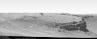
This first try shows a small Opportunity approaching Cape Verde on Sol 957.
I used James' great colorization pan 'Cape Verde from Duck Bay' (Homepage). Thanks James! Now five sols later ...
Attached thumbnail(s)
-------------------- - blue_scape / Nico -
|
|
 |
 
|
|
|
Oct 4 2006, 11:53 AM
Post
#2
|
|
|
Junior Member Group: Members Posts: 64 Joined: 24-May 06 From: Aberdeen, Scotland Member No.: 785 |
The scale of this place continues to confuse me. I thought the cliffs were much bigger than the scale you are implying, but I've done no analysis to back this up!
Aberdeenastro |
|
|
|
|
Oct 4 2006, 12:17 PM
Post
#3
|
|
 Junior Member Group: Members Posts: 57 Joined: 17-May 06 From: Houston, Texas Member No.: 776 |
I know what you mean. Back in Eagle crater, I first thought Opportunity was looking at a huge cliff off in the distance.

-------------------- |
|
|
|
|
Oct 4 2006, 01:33 PM
Post
#4
|
||
 The Poet Dude Group: Moderator Posts: 5551 Joined: 15-March 04 From: Kendal, Cumbria, UK Member No.: 60 |
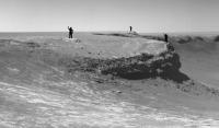
I believe it's been agreed that the famous "Mystery Men" provide a good sense of scale here...
(edit of larger image which can be found... oh... somewhere... don't have time to look! Sorry!) -------------------- |
|
|
|
|
|
|
Oct 4 2006, 01:53 PM
Post
#5
|
|
 Senior Member Group: Members Posts: 1619 Joined: 12-February 06 From: Bergerac - FR Member No.: 678 |
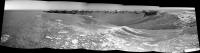
Hi,
Wow, Mystery Man is back. Hurray!  So, here is the Sol 956 navcam panorama, build with Autostitch and MMB. This software is very good to make antivigneting and gain compensation (thanks to Mhoward  ). ).
-------------------- |
|
|
|
|
Oct 4 2006, 01:58 PM
Post
#6
|
|
 Forum Contributor Group: Members Posts: 1374 Joined: 8-February 04 From: North East Florida, USA. Member No.: 11 |
I too thought it was a huge cliff, and was a bit dissapointed when it turned out to be a few cm tall. Endurance made up for that though, and now we have Victoria and maybe later some part of Big Crater and its rim.
|
|
|
|
|
Oct 4 2006, 02:01 PM
Post
#7
|
||
|
Senior Member Group: Members Posts: 2872 Joined: 22-April 05 From: Ridderkerk, Netherlands Member No.: 353 |
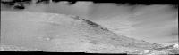
Another view of Victoria.
Taken with the L0 navcam on Sol 957. jvandriel
Attached thumbnail(s)
|
|
|
|
|
|
|
Oct 4 2006, 02:16 PM
Post
#8
|
||
|
Senior Member Group: Members Posts: 2872 Joined: 22-April 05 From: Ridderkerk, Netherlands Member No.: 353 |
Here is the view in the drive direction.
Taken with the L7 pancam on Sol 957. jvandriel
Attached thumbnail(s)
|
|
|
|
|
|
|
Oct 4 2006, 02:18 PM
Post
#9
|
|
|
Junior Member Group: Members Posts: 64 Joined: 24-May 06 From: Aberdeen, Scotland Member No.: 785 |
Thanks Ant103 and jvandriel for those amazing panoramas. I can't stop looking at them. However, the more I look at them the more I think that the tip of Cape Verde is a treacherous place to be. The Beacon area looks much safer.
Aberdeenastro (formerly known as Castor) |
|
|
|
|
Oct 4 2006, 02:28 PM
Post
#10
|
|
|
Member Group: Members Posts: 713 Joined: 30-March 05 Member No.: 223 |
QUOTE (Ant103 @ Oct 4 2006, 03:53 PM)  Hi, Wow, Mystery Man is back. Hurray! So, here is the Sol 956 navcam panorama, build with Autostitch and MMB. This software is very good to make antivigneting and gain compensation (thanks to Mhoward ).Wow, impressive ponorama ! I too have been trying to use Micheal's MMB viewer lately but didn't succeed in exporting the luminance corrected images for later use in panorama software (but I must admit that I have not spent much time reading the docs yet) How did you do the trick ? Also, how did you manage to get the level horizon in the panorama ? (autostich usually produces uneven horizon at the stitching seams and it's very cumbersome to find the right "greek" orientation parameters psi,phi....) Isn't there also a special feature in MMB that takes JPL metadata in order to correct the exact rover orientation ... would it be possible to use this for the Autostich orientation parameters ? |
|
|
|
|
Oct 4 2006, 02:35 PM
Post
#11
|
|
|
Senior Member Group: Moderator Posts: 4279 Joined: 19-April 05 From: .br at .es Member No.: 253 |
QUOTE (jvandriel @ Oct 4 2006, 04:16 PM) Here is the view in the drive direction. Given the concerns already raised here and on another thread I hope they don't really drive too much on that direction. 
|
|
|
|
|
Oct 4 2006, 02:52 PM
Post
#12
|
|
|
Forum Contributor Group: Members Posts: 1374 Joined: 8-February 04 From: North East Florida, USA. Member No.: 11 |
The Rover drivers know what they are doing. Remember even the tilt paramter of say 30 degrees will stop the rover dead in its tracks. Cabo Verde is not a 90 degree drop off by any means, infact I don't think any of the cliffs are, they all seem to have a slope then a drop. They also have several other s/w parameters to stop a rover driving over a cliff.
|
|
|
|
|
Oct 4 2006, 02:55 PM
Post
#13
|
|
|
Senior Member Group: Members Posts: 2872 Joined: 22-April 05 From: Ridderkerk, Netherlands Member No.: 353 |
Tesheiner.
Nirgal, for a good as possible match at the seams in the Sol 957 navcam pano I used the following parameters: Matching Options: Sift image: Min dim ( pixels ): 4400 Ransac Parameters: Alpha: 3 Beta: 0.1 Max Iterations: 4500 With the Manual Orientation parameters Phi and Psi you can level and straighten the Horizon. This is most of the time only a problem with the navcam images. The pancam panoramas are much better. jvandriel |
|
|
|
|
Oct 4 2006, 02:59 PM
Post
#14
|
|
|
Member Group: Members Posts: 713 Joined: 30-March 05 Member No.: 223 |
QUOTE (jvandriel @ Oct 4 2006, 04:55 PM) Un-needed quote removed - please remember not to quote when replying - it'd save us admins a lot of time better spend on playing with the imagery  jvandriel, Thanks a lot for giving the detail info about your settings ... greatly appreciated -> just moved the thread over to the image-tech-forum |
|
|
|
|
Oct 4 2006, 03:14 PM
Post
#15
|
|
|
Senior Member Group: Members Posts: 1619 Joined: 12-February 06 From: Bergerac - FR Member No.: 678 |
For Nirgal : I discover the method few weeks ago. To have the images corrected for the pan, go into "File > Advandced > Export Pan Images". After, choose the directory and "export".
For the horizon, when it is visible (so, at Meridiani, you often see the horizon...), I take the first image of the pano (the very first at the left) and I calculate the inclination of it. And in Autostitch, I put the inclination number in the "psi" parameter. After, you have to adjust the other parameter if it's necessary (phi for curve the whole pano, theta for bend the pano around the first pic). This the way I proceed but, some times, by seeing the individual pictures in the finished pano, the horizon is not plane. -------------------- |
|
|
|
|

|
Lo-Fi Version | Time is now: 27th September 2024 - 02:55 AM |
|
RULES AND GUIDELINES Please read the Forum Rules and Guidelines before posting. IMAGE COPYRIGHT |
OPINIONS AND MODERATION Opinions expressed on UnmannedSpaceflight.com are those of the individual posters and do not necessarily reflect the opinions of UnmannedSpaceflight.com or The Planetary Society. The all-volunteer UnmannedSpaceflight.com moderation team is wholly independent of The Planetary Society. The Planetary Society has no influence over decisions made by the UnmannedSpaceflight.com moderators. |
SUPPORT THE FORUM Unmannedspaceflight.com is funded by the Planetary Society. Please consider supporting our work and many other projects by donating to the Society or becoming a member. |
|