Plains and annulus, what's up at Meridiani |

  |
Plains and annulus, what's up at Meridiani |
 Jan 3 2007, 04:18 AM Jan 3 2007, 04:18 AM
Post
#1
|
|
 Senior Member  Group: Members Posts: 3419 Joined: 9-February 04 From: Minneapolis, MN, USA Member No.: 15 |
I was looking at the MRO image of the Opportunity landing site, and I was struck once again at how incredibly similar the plains on which Oppy landed and the annulus around Victoria look. They could be the exact same landform, looking at it from orbit at MRO's resolution.
The soils and drifts in the annulus also look more like the plains outside of Eagle and Endurance than anything we saw in the dune seas of the "etched" terrain. Granted, the concretions in the annulus are smaller and more conical than the more spherical concretions up north -- but all in all, the surfaces are remarkably similar. Now, the annulus around Victoria *seems* to be arrayed in an ejecta-like pattern around the crater -- but the crater itself seems too old to exhibit an intact ejecta blanket. And -- and this is the crucial question -- if the terrain in Vickie's annulus is in some way a result of her ejecta blanket, then how do you explain almost identical terrain to the north, which isn't in any way visually associated with any ejecta blanket from any size of an impact? I'd be tempted to think that such a strong visual similarity would have to indicate similarities in composition and/or origin. I've read an initial geological analysis of the plains unit. I fail to see why the processes suggested in that analysis (early aqueous alteration, polygonal cracking due to dessication, and finally aeons of aeolian stripping and re-deposition) could cause a very similar unit that seems to be defined by the boundaries of Victoria's ejecta blanket. There are even traces of the same dessicative cracking in the annulus, which seems entirely absent (or masked) in the etched terrain. Anyone want to take a shot at why these units seem so similar, and if they *are* the product of the same processes, how these processes can modify *only* the annulus around Victoria, not affecting the large drifts and exposed evaporitic sandstone that surround it? -the other Doug -------------------- The trouble ain't that there is too many fools, but that the lightning ain't distributed right. -Mark Twain
|
 |
 
|
|
Jan 3 2007, 01:29 PM
Post
#2
|
|||
 Senior Member Group: Members Posts: 2488 Joined: 17-April 05 From: Glasgow, Scotland, UK Member No.: 239 |
oDoug:
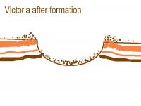
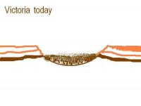
I don't think Victoria - as I've said before - should be considered as a crater at all. It's an ex-crater, worn away and with precious little in the way of crater morphology left. My preferred name for such a hole in the ground is a 'Diablo', named for an early Spanish name for the Barringer Meteor crater in Arizona. In terms of structure, the overturned layers associated with the ejecta blanket are gone, blown away in the wind. The annulus is, I'd suggest, a weathering effect, a 'dead zone' such as we saw at the peak of Husband Hill. Here are a couple of very naive diagrams illustrating where I think we're at:
So, in essence, there's precious little of the crater itself left, though there *is* a hole. And that means good stratigraphy, as we can so clearly see. Bob Shaw -------------------- Remember: Time Flies like the wind - but Fruit Flies like bananas!
|
||
|
|
|
||
|
Jan 3 2007, 07:23 PM
Post
#3
|
|
 Senior Member Group: Members Posts: 1229 Joined: 24-December 05 From: The blue one in between the yellow and red ones. Member No.: 618 |
 Hey, Guys, you seem to be transplanting a major discussion from the MER>Victoria's Stratigraphy thread into MRO. I think this is a bad idea, since we will inevitably be referring mainly to evidence collected at ground level. MRO pictures may look "similar", but why use them when we've got MIs to compare? Hey, Guys, you seem to be transplanting a major discussion from the MER>Victoria's Stratigraphy thread into MRO. I think this is a bad idea, since we will inevitably be referring mainly to evidence collected at ground level. MRO pictures may look "similar", but why use them when we've got MIs to compare? 
-------------------- My Grandpa goes to Mars every day and all I get are these lousy T-shirts!
|
|
|
|
|
Jan 4 2007, 03:43 AM
Post
#4
|
|
|
Senior Member Group: Members Posts: 3419 Joined: 9-February 04 From: Minneapolis, MN, USA Member No.: 15 |
I understand your point, Shaka, but in this case, I think the selection of forum is valid. We're talking about landforms which reveal themselves best at larger scales. I was mostly pointing out that the plains and the annulus appear to be the same unit at larger scales, but don't seem to have an obvious connection as to how they formed.
Since it's a discussion about large units which became even more apparently similar at the MRO observation scales (which are nicely zoomable from large scale to fine scale), I figure it belongs here. An MI tells you what something looks like in a portion of the surface the size of a postage stamp. Yes, you can draw conclusions from differences in MIs, but MIs can vary a lot in distances of meters within the same unit. There's nothing like seeing how many kilometers, not meters, that a given unit extends, and how its boundaries are characterized. That's actually done better from orbit than from the ground...  So, now that we can see how the boundaries are characterized in the MRO images a lot better than we could in the MOC images, I figure it's time to start geologizing about them... -the other Doug -------------------- The trouble ain't that there is too many fools, but that the lightning ain't distributed right. -Mark Twain
|
|
|
|
|
Jan 4 2007, 06:42 AM
Post
#5
|
|
 Senior Member Group: Members Posts: 2228 Joined: 1-December 04 From: Marble Falls, Texas, USA Member No.: 116 |
I think this is an interesting discussion, and I suppose it could be in either forum. I did want to throw in my two cents worth, though.
It appears that there are two unconsolidated geological units above the bedrock. The layered ripples are on top, and they vary considerably in thickness and extent. Below that seems to be the Halfpipe formation, which also varies in thickness and extent. I am convinced that the Halfpipe formation is widespread on Meridiani Planum, and that is what Opportunity was driving on near Eagle and Endurance, as well as on Victoria's annulus. Those seem to be areas where Halfpipe was present and the layered ripples were very thin or absent.This concept was previously discussed in the Halfpipe Formation topic. Imho, it is worthy of further geologizing. -------------------- ...Tom
I'm not a Space Fan, I'm a Space Exploration Enthusiast. |
|
|
|
|

|
Lo-Fi Version | Time is now: 16th April 2024 - 06:53 PM |
|
RULES AND GUIDELINES Please read the Forum Rules and Guidelines before posting. IMAGE COPYRIGHT |
OPINIONS AND MODERATION Opinions expressed on UnmannedSpaceflight.com are those of the individual posters and do not necessarily reflect the opinions of UnmannedSpaceflight.com or The Planetary Society. The all-volunteer UnmannedSpaceflight.com moderation team is wholly independent of The Planetary Society. The Planetary Society has no influence over decisions made by the UnmannedSpaceflight.com moderators. |
SUPPORT THE FORUM Unmannedspaceflight.com is funded by the Planetary Society. Please consider supporting our work and many other projects by donating to the Society or becoming a member. |
|