Titan's Equatorial Sand Seas |

Titan's Equatorial Sand Seas |
 May 7 2007, 03:53 PM May 7 2007, 03:53 PM
Post
#401
|
|||||||
 Senior Member  Group: Moderator Posts: 2785 Joined: 10-November 06 From: Pasadena, CA Member No.: 1345 |
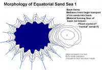
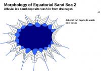
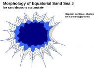
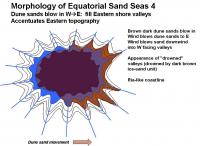
Ive put together a sequence of events that could explain the morphology of the Equatorial Sand Seas. (An example basin similar to Shangri-La is shown)
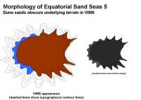
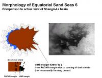
This could explain the ria-like topography [http://en.wikipedia.org/wiki/Ria] on the Eastern shore, as well as the VIMS dark blue western parts of the Sand seas, and the placement of the dark brown unit on the Eastern parts of the sand seas. 1. Basin formation. 2. Water-ice sand deposition [slowly, suddenly?] forms an ice-sand margin 3. Mobile dark brown dune sands deposit on E side, depositing inland up W facing valleys.
:attachment] The dark brown sands will blow in following the predominantly W winds and make a dust coating on low-lying terrains on the eastern margins. This will be visible by VIMS and ISS as the dark-bright margin, placed inland from the "real margin" and will accentuate the local topography as seen by optical instruments. This accentuation on the E margin will make the Equatorial Sand Sea visible margin look swoopy and windblown (in effect, it is) from the dark basin. Similarly, the W margin will have a dark blue zone that appears blown from the western bright areas. On the Eastern shore, the RADAR images will place the smooth-dark/mottled gray boundary far to the W of the VIMS brown dark-bright margin. (RADAR should be able to penetrate a thin coating of dark sands). The features in the limbo zone have been covered by dark sands, perhaps not enough to form dune structures, but enough to cover up the ice-sand margin, the near shore terrain, and perhaps even some of the underlying bright terrain. This makes the deposition sequence in the Equatorial Sand Seas: 1: Basin formation 2. Major water ice sand emplacement 3. Dune sands cover up low-lying downwind valleys (enough to mask visible imagery) Other Equatorial Sand Sea basins should look very similar around Titan: Shangri-La, Belet, Senkyo, Fensal and Quivra. Local winds may play a bonus role, but the overall trend of dark sand deposition up valley should be towards the E. For example: the false-color image in Figure 6 of the Soderblom paper seems to imply a predominant wind vector in Fensal and Quivra to the ESE. [Im pretty sure all this has been described in pieces before, but it gave me a really great excuse to play with PowerPoint.  ] ]-Mike
Attached thumbnail(s)
-------------------- Some higher resolution images available at my photostream: http://www.flickr.com/photos/31678681@N07/
|
||||||
 |
 
|
||||||
 Juramike Titan's Equatorial Sand Seas May 7 2007, 03:53 PM
 Juramike Comparison of Pseudocolorized ISS-RADAR vs. recent... Mar 26 2009, 12:54 AM Juramike Blink animation of PIA111829 (RADAR stereogram) ov... Mar 26 2009, 01:06 AM Juramike From Emily's blog entry today:
"Still, th... Oct 9 2010, 01:35 AM Juramike Dredging this thread back up from the long past. W... Mar 16 2016, 03:47 AM ngunn Thanks for posting those Mike. The second paper es... Mar 16 2016, 07:23 PM
Juramike Comparison of Pseudocolorized ISS-RADAR vs. recent... Mar 26 2009, 12:54 AM Juramike Blink animation of PIA111829 (RADAR stereogram) ov... Mar 26 2009, 01:06 AM Juramike From Emily's blog entry today:
"Still, th... Oct 9 2010, 01:35 AM Juramike Dredging this thread back up from the long past. W... Mar 16 2016, 03:47 AM ngunn Thanks for posting those Mike. The second paper es... Mar 16 2016, 07:23 PM rlorenz Loosely related to this topic, and the general fla... Mar 20 2016, 02:05 PM
  |

|
Lo-Fi Version | Time is now: 23rd May 2024 - 10:27 AM |
|
RULES AND GUIDELINES Please read the Forum Rules and Guidelines before posting. IMAGE COPYRIGHT |
OPINIONS AND MODERATION Opinions expressed on UnmannedSpaceflight.com are those of the individual posters and do not necessarily reflect the opinions of UnmannedSpaceflight.com or The Planetary Society. The all-volunteer UnmannedSpaceflight.com moderation team is wholly independent of The Planetary Society. The Planetary Society has no influence over decisions made by the UnmannedSpaceflight.com moderators. |
SUPPORT THE FORUM Unmannedspaceflight.com is funded by the Planetary Society. Please consider supporting our work and many other projects by donating to the Society or becoming a member. |
|