

Post Solar Conjunction/Santorini Study Drive, The second leg in our Journey to Endeavor Crater |

  |
Post Solar Conjunction/Santorini Study Drive, The second leg in our Journey to Endeavor Crater |
 Mar 6 2009, 08:17 AM Mar 6 2009, 08:17 AM
Post
#406
|
||||
|
Junior Member  Group: Members Posts: 44 Joined: 25-February 08 From: Greece, Komotini Member No.: 4055 |
Paolo, I` m not sure I understood the route you said Opportunity is going to use to arrive to Endeavour crater. Is it going to be like one of the routes I draw? Which (hypothetical) route resembles more the planned one? Are we really 2-3 km away from "parking lot" terrain? Are we going to pass near the "mini-Endurance" crater (nearly in the middle of the route)? Explain me, please. Thank you.

Attached thumbnail(s)
-------------------- "It`s one small step for a man. A giant leap for all mankind!" Armstrong, Apollo 11, 1969.
|
|||
 |
 
|
|||
|
Mar 6 2009, 09:38 AM
Post
#407
|
||
 Member Group: Members Posts: 236 Joined: 5-June 08 From: Udon Thani Member No.: 4185 |
QUOTE (Juramike @ Mar 6 2009, 10:43 AM)  Different wind local? or the first sign of the "confusion" zone that can be seen at the southern end of the HiRise crop? Agree with you, I don't like the look of it also. There does seem to be a whole line of confused dunes more or less leading from the present position towards the center of Porcupine. To the north and south of this line is better terrain with also more bedrock. Bit weird why there are confused dunes in one line, with bedrock patches on both sides but not inside this area.
Furthermore, she should have passed a small crater, which is still quite close to the east of the sol 1816 position, don't know whether it shows up on any of the images? Regards, Geert. |
|
|
|
|
|
|
Mar 6 2009, 10:39 AM
Post
#408
|
|
|
Member Group: Admin Posts: 976 Joined: 29-September 06 From: Pasadena, CA - USA Member No.: 1200 |
QUOTE (Ipparchus @ Mar 6 2009, 12:17 AM) Paolo, I` m not sure I understood the route you said Opportunity is going to use to arrive to Endeavour crater. Is it going to be like one of the routes I draw? Which (hypothetical) route resembles more the planned one? Are we really 2-3 km away from "parking lot" terrain? Are we going to pass near the "mini-Endurance" crater (nearly in the middle of the route)? Explain me, please. Thank you. The route is similar to the rightmost one you posted. In 2-3 Km we should be clearing an area that has a large concentration of "purgatoids" (=purgatory like ripples). Then we should be able to start heading east. The "parking lot" terrain is much, much further out. Paolo -------------------- Disclaimer: all opinions, ideas and information included here are my own,and should not be intended to represent opinion or policy of my employer.
|
|
|
|
|
Mar 6 2009, 12:40 PM
Post
#409
|
||
 Senior Member Group: Moderator Posts: 2785 Joined: 10-November 06 From: Pasadena, CA Member No.: 1345 |
QUOTE (Geert @ Mar 6 2009, 04:38 AM) Bit weird why there are confused dunes in one line, with bedrock patches on both sides but not inside this area. I'm wondering if the bedrock patches (and associated higher dunes at the margins) affect the local winds. Another possibility is that the SW-NE orientation places it parallel to some of the repeating patterns (organe arrows indicated banding zones) seen to the E of Porcupine. Possibly from a more recent wind regime?
-Mike [EDIT: Actually, looking at this from way back, I'm wondering if the some of the current bedrock pattern is part of this overall pattern as well. Did winds along a NW-SE vector cause some sort of rotor effect and scrub/deposit sand in a series of SW-NE oriented bands?] -------------------- Some higher resolution images available at my photostream: http://www.flickr.com/photos/31678681@N07/
|
|
|
|
|
|
|
Mar 6 2009, 01:10 PM
Post
#410
|
|||
|
Senior Member Group: Moderator Posts: 4279 Joined: 19-April 05 From: .br at .es Member No.: 253 |
> I'm wondering if the bedrock patches (and associated higher dunes at the margins) affect the local winds. ...
Here's my take. If you have a look to the area east of Porcupine in Google Earth with e.g 2x vertical exaggeration you'll see it's in a hollow and that might disturb the N-S local winds.
In another topic, here's a quick mosaic of some latest navcams from sol 1818. The crater to the left (SE) is a tiny dot on the map here.
|
||
|
|
|
||
|
Mar 6 2009, 04:47 PM
Post
#411
|
|
 Senior Member Group: Moderator Posts: 3431 Joined: 11-August 04 From: USA Member No.: 98 |
 Opportunity sol 1818; anaglyph rectilinear projection of Navcam images. Don't know what the crater is called yet. |
|
|
|
|
Mar 7 2009, 01:51 AM
Post
#412
|
|
|
Member Group: Members Posts: 139 Joined: 14-October 05 From: Toronto, Canada Member No.: 529 |
QUOTE (Tesheiner @ Mar 6 2009, 08:10 AM) > I'm wondering if the bedrock patches (and associated higher dunes at the margins) affect the local winds. ... Here's my take. If you have a look to the area east of Porcupine in Google Earth with e.g 2x vertical exaggeration you'll see it's in a hollow and that might disturb the N-S local winds. We sometime seem to forget that this is a three dimensional surface that we are driving over. There is bound to be local effects due to elevation. 
-------------------- -- Robin
|
|
|
|
|
Mar 7 2009, 12:23 PM
Post
#413
|
|
 Senior Member Group: Members Posts: 1619 Joined: 12-February 06 From: Bergerac - FR Member No.: 678 |
Hi all!
 A long, loooooooooong time without posting anything. I put the end of a period where I did not produce any picture. I don't know why. Less motivation? The end of Phoenix? I don't know. So, I'm back, with 3 panoramic picture of Oppy on the road. Sol 1816 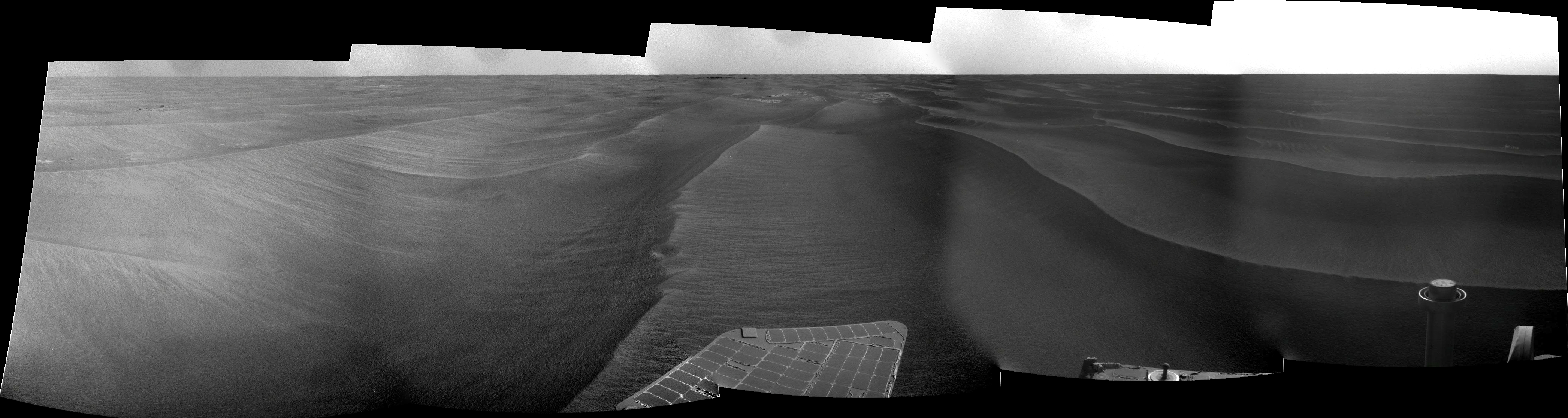 Sol 1817 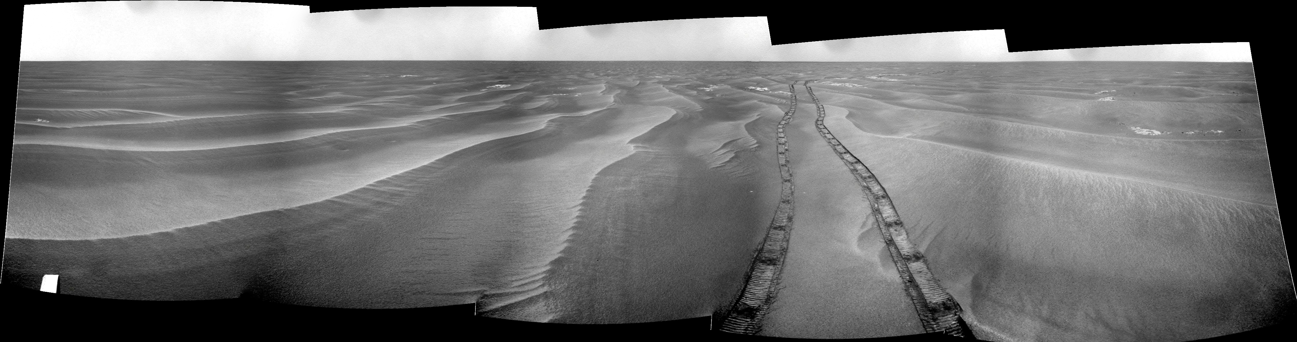 NOTE : UPDATED Sol 1818 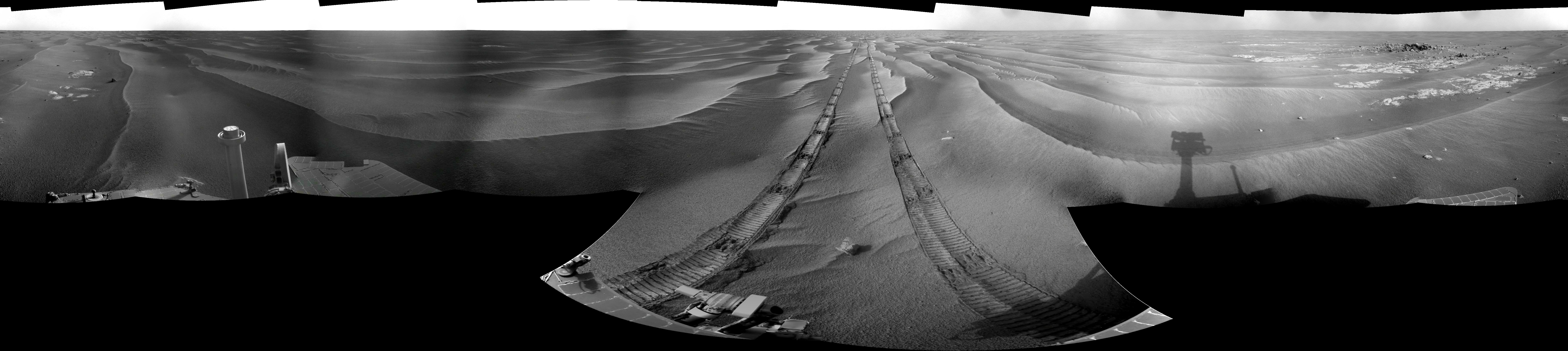 Happy to be back  PS : I follow this forum during my "non-work" period, and you've always doing great stuffs (tesheiner, MHoward, Stu, James Canvin, and I certainly miss other).
-------------------- |
|
|
|
|
Mar 7 2009, 01:12 PM
Post
#414
|
|
 The Poet Dude Group: Moderator Posts: 5551 Joined: 15-March 04 From: Kendal, Cumbria, UK Member No.: 60 |
Welcome back, Ant! Missed your contributions. Hopefully you'll be showing us some "Endeavour, Ho!" images soon...
-------------------- |
|
|
|
|
Mar 7 2009, 02:54 PM
Post
#415
|
|
 Senior Member Group: Moderator Posts: 2262 Joined: 9-February 04 From: Melbourne - Oz Member No.: 16 |
Thanks Ant - welcome back
I've been waiting for the rest of the Ranger Crater pan. However I've just checked the PDT and it looks like the second tier has already been deleted from the rover without being downlinked. So we are left with a long thin 19x1 image.  Click image James -------------------- |
|
|
|
|
Mar 7 2009, 11:43 PM
Post
#416
|
|
|
Senior Member Group: Members Posts: 1619 Joined: 12-February 06 From: Bergerac - FR Member No.: 678 |
A big thanks for your back welcoming (can I said that?
 ). This gives me more energy to continue ). This gives me more energy to continue (and I have a " big event" for this month )
-------------------- |
|
|
|
|
Mar 8 2009, 08:12 AM
Post
#417
|
|
|
Senior Member Group: Moderator Posts: 4279 Joined: 19-April 05 From: .br at .es Member No.: 253 |
QUOTE (mhoward @ Mar 6 2009, 05:47 PM) Don't know what the crater is called yet. It has been named Resolution. > 01821::p2421::19::96::96::0::0::4::196::pancam_resolution_crater_L257R267 |
|
|
|
|
Mar 8 2009, 03:07 PM
Post
#418
|
|
|
Senior Member Group: Moderator Posts: 2262 Joined: 9-February 04 From: Melbourne - Oz Member No.: 16 |
Well that was a little unexpected. North-West?
http://qt.exploratorium.edu/mars/opportuni...93P0675R0M1.JPG -------------------- |
|
|
|
|
Mar 8 2009, 03:21 PM
Post
#419
|
|
|
Member Group: Members Posts: 530 Joined: 21-March 06 From: Canada Member No.: 721 |
Maybe they're testing SE drivability but in reverse.
|
|
|
|
|
Mar 8 2009, 05:01 PM
Post
#420
|
|
|
Senior Member Group: Moderator Posts: 4279 Joined: 19-April 05 From: .br at .es Member No.: 253 |
Strange move.
I saw the driving plan for today followed by a pancam mosaic of "Resolution Crater" so I thought the intention was to do a little bump towards that little crater to better image it during sol 1821. Now I really don't know which feature is Resolution. Let's wait for tomorrow. |
|
|
|
|

|
Lo-Fi Version | Time is now: 22nd September 2024 - 12:42 PM |
|
RULES AND GUIDELINES Please read the Forum Rules and Guidelines before posting. IMAGE COPYRIGHT |
OPINIONS AND MODERATION Opinions expressed on UnmannedSpaceflight.com are those of the individual posters and do not necessarily reflect the opinions of UnmannedSpaceflight.com or The Planetary Society. The all-volunteer UnmannedSpaceflight.com moderation team is wholly independent of The Planetary Society. The Planetary Society has no influence over decisions made by the UnmannedSpaceflight.com moderators. |
SUPPORT THE FORUM Unmannedspaceflight.com is funded by the Planetary Society. Please consider supporting our work and many other projects by donating to the Society or becoming a member. |
|


