First public release of Kaguya data |

  |
First public release of Kaguya data |
 Nov 5 2009, 05:27 AM Nov 5 2009, 05:27 AM
Post
#46
|
|
 Senior Member  Group: Moderator Posts: 3431 Joined: 11-August 04 From: USA Member No.: 98 |
That's extraordinary, Bjorn.
Earlier today I updated the second version of my normal map (link above), to smooth over a few spots where there are glitches in the source data. |
 |
 
|
|
Nov 5 2009, 09:18 PM
Post
#47
|
||||||
|
Founder Group: Chairman Posts: 14431 Joined: 8-February 04 Member No.: 1 |
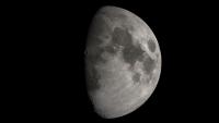
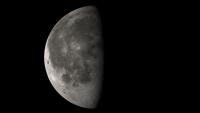
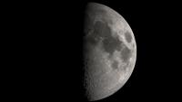
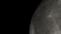
Finally figured out self shadowing terrain that I've been struggling with for a while... a couple of what I THINK are realistic renders, plus one with UBER-EXAGER-TERRAIN and a final one that's exagerated, but only to look a bit more realistic. It seems I have to turn up above and beyond what I'd expect the numbers to require for realistic terrain - perhaps because of the comparatively low level of detail in the terrain models.
And because the resolution isn't that good - a bit of foreshortening to get a look at Eddington for Stu
Attached thumbnail(s)
|
|||||
|
|
|
|||||
|
Nov 5 2009, 10:11 PM
Post
#48
|
|
 The Poet Dude Group: Moderator Posts: 5551 Joined: 15-March 04 From: Kendal, Cumbria, UK Member No.: 60 |
These Kaguya-derived images are absolutely stunning, great work everyone. This actually feels like a planetary encounter, with new images of a new world for us all to drool over...
And thanks for the Eddington pic Doug, much appreciated. I've some big talks coming up before Christmas and really want to be able to show off that crater, for obvious reasons :-) -------------------- |
|
|
|
|
Nov 5 2009, 10:23 PM
Post
#49
|
|
 Senior Member Group: Admin Posts: 4763 Joined: 15-March 05 From: Glendale, AZ Member No.: 197 |
I like the exaggerated one. Somehow on a globe it doesn't seem to be terribly out of place. I think it's useful for understanding the terrain and relative elevations and crater depths.
-------------------- If Occam had heard my theory, things would be very different now.
|
|
|
|
|
Nov 6 2009, 12:41 PM
Post
#50
|
|
|
Junior Member Group: Members Posts: 94 Joined: 15-October 09 Member No.: 4979 |
I wonder when we'll see the first program that accurately renders this topographical data so we can really plan our lunar observations...
Excellent renders, everyone! |
|
|
|
|
Nov 6 2009, 03:26 PM
Post
#51
|
||
|
Senior Member Group: Moderator Posts: 3431 Joined: 11-August 04 From: USA Member No.: 98 |
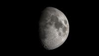
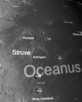
For those of you wondering, as I was, which one is Eddington Crater...
Attached thumbnail(s)
|
|
|
|
|
|
|
Nov 6 2009, 03:29 PM
Post
#52
|
|
|
Founder Group: Chairman Posts: 14431 Joined: 8-February 04 Member No.: 1 |
I had to look it up as well
 And S_Walker - the answer is about 2hrs, 40 minutes. The post following yours qualifies I think. And S_Walker - the answer is about 2hrs, 40 minutes. The post following yours qualifies I think.Just rendering a near-side 300 frame animation of dawn to dusk with very exaggerated terrain |
|
|
|
|
Nov 6 2009, 05:39 PM
Post
#53
|
|
|
Junior Member Group: Members Posts: 94 Joined: 15-October 09 Member No.: 4979 |
QUOTE (djellison @ Nov 6 2009, 10:29 AM)  I had to look it up as well And S_Walker - the answer is about 2hrs, 40 minutes. The post following yours qualifies I think.Thanks. What about those who don't own an iPhone? |
|
|
|
|
Nov 6 2009, 06:07 PM
Post
#54
|
|
|
Founder Group: Chairman Posts: 14431 Joined: 8-February 04 Member No.: 1 |
There's Google Earth/Moon/Mars
|
|
|
|
|
Nov 6 2009, 06:13 PM
Post
#55
|
|
|
Senior Member Group: Moderator Posts: 3431 Joined: 11-August 04 From: USA Member No.: 98 |
QUOTE (djellison @ Nov 6 2009, 11:07 AM) There's Google Earth/Moon/Mars Nah... Google Moon is nice but it doesn't use a topographic map for lighting as far as I remember? And I'm not sure if you can set it to show the view from your backyard. Can Celestia be set to view the Moon from a position on Earth? At least two of us have already produced normal maps; it's a small step from that to the amazing screenshots that volcanopele was posting. I imagine what S_Walker really wants is something that does Bjorn- or Doug- type rendering to show the Moon from a location and time on Earth. Don't know about that. But Celestia or Moon Globe would probably be good enough for a lot of purposes. |
|
|
|
|
Nov 6 2009, 06:33 PM
Post
#56
|
|
|
Junior Member Group: Members Posts: 94 Joined: 15-October 09 Member No.: 4979 |
QUOTE (mhoward @ Nov 6 2009, 01:13 PM) I imagine what S_Walker really wants is something that does Bjorn- or Doug- type rendering to show the Moon from a location and time on Earth. Don't know about that. But Celestia or Moon Globe would probably be good enough for a lot of purposes. Similar; I'd like something like Virtual Moon Atlas or RITI Lunar Map Pro so that I can better plot interesting features to observe under favorable librations each month in Chuck Wood's Explore the Moon column in S&T (I edit it each month). |
|
|
|
|
Nov 6 2009, 06:50 PM
Post
#57
|
|
|
Senior Member Group: Moderator Posts: 3431 Joined: 11-August 04 From: USA Member No.: 98 |
I see. Well as Doug points out, Moon Globe may well be first out the door with those features, for anyone who has an iPhone or iPod Touch. And it's free. I'll be submitting the update using LALT data quite soon. (End promotion.)
I don't own it, but RITI Lunar Map Pro looks like they definitely *should* upgrade to the LALT data for lighting. (Adding: Ironically, the LALT data is actually less sharp than the airbrushed topographic map they seem to be using - I know that because I was using it too. So they may have a problem with that. But even though it's low resolution, the global LALT map we've seen is vastly more accurate.) Virtual Moon Atlas looks like it doesn't do topopgraphic lighting, so that would be more of a reach. |
|
|
|
|
Nov 6 2009, 07:52 PM
Post
#58
|
|
|
Junior Member Group: Members Posts: 35 Joined: 28-September 05 From: Seattle, WA Member No.: 514 |
QUOTE (mhoward @ Nov 6 2009, 10:13 AM) Nah... Google Moon is nice but it doesn't use a topographic map for lighting as far as I remember? And I'm not sure if you can set it to show the view from your backyard. Can Celestia be set to view the Moon from a position on Earth? At least two of us have already produced normal maps; it's a small step from that to the amazing screenshots that volcanopele was posting. Celestia can do this, but the UI for doing so isn't as convenient as one would like. The Celestia UI was designed around moving through space, and features for viewing from the Earth's surface have never gotten the attention that they deserve. But, see question #5 here: http://shatters.net/forum/viewtopic.php?p=118149#p118149 We're in the process of making the Kaguya map the default in Celestia, and a UI overall is coming in the not-too-distant future. --Chris (I've got an iPhone and love the Moon and Mars globe apps, btw. Great work!) |
|
|
|
|
Nov 6 2009, 08:20 PM
Post
#59
|
|
|
Senior Member Group: Moderator Posts: 3431 Joined: 11-August 04 From: USA Member No.: 98 |
Thanks. I'm also a Celestia fan.
|
|
|
|
|
Nov 6 2009, 10:09 PM
Post
#60
|
|
|
Member Group: Members Posts: 890 Joined: 18-November 08 Member No.: 4489 |
mhoward
there will be a hires add on for celestia soon .As soon as i replace my hand made map on the motherload |
|
|
|
|

|
Lo-Fi Version | Time is now: 20th April 2024 - 05:57 AM |
|
RULES AND GUIDELINES Please read the Forum Rules and Guidelines before posting. IMAGE COPYRIGHT |
OPINIONS AND MODERATION Opinions expressed on UnmannedSpaceflight.com are those of the individual posters and do not necessarily reflect the opinions of UnmannedSpaceflight.com or The Planetary Society. The all-volunteer UnmannedSpaceflight.com moderation team is wholly independent of The Planetary Society. The Planetary Society has no influence over decisions made by the UnmannedSpaceflight.com moderators. |
SUPPORT THE FORUM Unmannedspaceflight.com is funded by the Planetary Society. Please consider supporting our work and many other projects by donating to the Society or becoming a member. |
|