Titan Relative Elevation Model, using channel and valley relationships |

Titan Relative Elevation Model, using channel and valley relationships |
 Jan 25 2010, 05:06 AM Jan 25 2010, 05:06 AM
Post
#1
|
|||
 Senior Member  Group: Moderator Posts: 2785 Joined: 10-November 06 From: Pasadena, CA Member No.: 1345 |
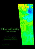
Something I've been playing with for a few months - using channel and valley relationships in different terrain units to infer relative elevation.
Low order --> high order = upstream --> downstream = higher elevation --> lower elevation. While many of the terrain units could be placed on a relative scale, others are speculative. So this is partly artistic speculation rather than hard science. Still, most of the observed relationships seem to fit the model. I also creatively blurred things to soften the transitions. Pixel values are relative, not absolute. Relative Elevation Model of Sikun Labyrinthus, Titan:
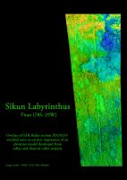
Overlay of PIA10219 (crop of T39 SAR RADAR Swath) and the derived Relative Elevation Model of Sikun Labyrinthus, Titan:
-Mike -------------------- Some higher resolution images available at my photostream: http://www.flickr.com/photos/31678681@N07/
|
||
 |
 
|
||
 Juramike Titan Relative Elevation Model Jan 25 2010, 05:06 AM
 titanicrivers That is a beautiful image Mike. (you're well o... Jan 25 2010, 06:52 AM ustrax Looks wonderful to me Mike! Jan 25 2010, 02:07 PM Phil Stooke Yes, a very nice image and an interesting idea.
P... Jan 25 2010, 02:20 PM ngunn Very pretty indeed, and with the potential to link... Jan 25 2010, 03:37 PM 4th rock from the sun Interesting idea... Perhaps the elevation could be... Jan 25 2010, 03:46 PM Juramike Test render by Bjorn Jonsson:
Jan 26 2010, 10:39 PM ngunn Now that is dangerously believable (or would be wi... Jan 26 2010, 10:56 PM nprev You (and Bjorn) are definitely onto something here... Jan 26 2010, 11:33 PM Juramike Now with color added. (My attempt at recolorizing... Jan 27 2010, 03:37 AM
titanicrivers That is a beautiful image Mike. (you're well o... Jan 25 2010, 06:52 AM ustrax Looks wonderful to me Mike! Jan 25 2010, 02:07 PM Phil Stooke Yes, a very nice image and an interesting idea.
P... Jan 25 2010, 02:20 PM ngunn Very pretty indeed, and with the potential to link... Jan 25 2010, 03:37 PM 4th rock from the sun Interesting idea... Perhaps the elevation could be... Jan 25 2010, 03:46 PM Juramike Test render by Bjorn Jonsson:
Jan 26 2010, 10:39 PM ngunn Now that is dangerously believable (or would be wi... Jan 26 2010, 10:56 PM nprev You (and Bjorn) are definitely onto something here... Jan 26 2010, 11:33 PM Juramike Now with color added. (My attempt at recolorizing... Jan 27 2010, 03:37 AM
 rlorenz QUOTE (Juramike @ Jan 26 2010, 10:37 PM) ... Jan 29 2010, 05:21 PM remcook wow! If nothing else, it's very very prett... Jan 27 2010, 08:31 AM ustrax Mãezinha!!!
I love the path you guys a... Jan 27 2010, 11:16 AM djellison A little something like this?
http://www.youtube.c... Jan 27 2010, 03:14 PM ustrax QUOTE (djellison @ Jan 27 2010, 03:14 PM)... Jan 27 2010, 03:28 PM Juramike Totally WOW!!!!
[Co-worker just c... Jan 27 2010, 03:31 PM belleraphon1 All... and in this case Mike and Bjorn and Doug...... Jan 27 2010, 10:45 PM imipak I feel like I'm seeing Titan for the first tim... Jan 28 2010, 09:45 PM machi Really amazing work Mike, Björn and Doug!
I h... Jan 29 2010, 03:11 PM djellison http://www.youtube.com/watch?v=5AohxBIDukc
Going ... Jan 29 2010, 07:35 PM nprev ....damn!!! Jan 29 2010, 07:38 PM ustrax MAG-NÍ-FI-CO
Now...when you guys have a little spa... Jan 30 2010, 12:01 AM Juramike Here is an artisitic study to get the actual color... Feb 1 2010, 04:42 AM Juramike Based on the coordinated ISS colorization, here is... Feb 1 2010, 04:47 AM neo56 AMAZING !!! I can't wait to see th... Mar 6 2010, 05:50 PM Juramike QUOTE (neo56 @ Mar 6 2010, 01:50 PM) You ... Mar 7 2010, 12:00 AM volcanopele Even when undergrad students are involved, that ... Mar 7 2010, 03:05 AM Webscientist Bravo for the analytical map of Sikun Labyrinthus... Mar 7 2010, 09:34 AM Juramike QUOTE (Webscientist @ Mar 7 2010, 05:34 A... Mar 7 2010, 01:40 PM ngunn QUOTE (Juramike @ Mar 7 2010, 01:40 PM) s... Mar 7 2010, 06:00 PM Juramike Titan flyover movie sequence, the full length rend... Mar 7 2010, 06:33 PM nprev That's just freaky cool. Truly bizarre land... Mar 7 2010, 07:10 PM Juramike The Sikun Labyrinthus relative elevation model was... Sep 24 2010, 07:29 PM
rlorenz QUOTE (Juramike @ Jan 26 2010, 10:37 PM) ... Jan 29 2010, 05:21 PM remcook wow! If nothing else, it's very very prett... Jan 27 2010, 08:31 AM ustrax Mãezinha!!!
I love the path you guys a... Jan 27 2010, 11:16 AM djellison A little something like this?
http://www.youtube.c... Jan 27 2010, 03:14 PM ustrax QUOTE (djellison @ Jan 27 2010, 03:14 PM)... Jan 27 2010, 03:28 PM Juramike Totally WOW!!!!
[Co-worker just c... Jan 27 2010, 03:31 PM belleraphon1 All... and in this case Mike and Bjorn and Doug...... Jan 27 2010, 10:45 PM imipak I feel like I'm seeing Titan for the first tim... Jan 28 2010, 09:45 PM machi Really amazing work Mike, Björn and Doug!
I h... Jan 29 2010, 03:11 PM djellison http://www.youtube.com/watch?v=5AohxBIDukc
Going ... Jan 29 2010, 07:35 PM nprev ....damn!!! Jan 29 2010, 07:38 PM ustrax MAG-NÍ-FI-CO
Now...when you guys have a little spa... Jan 30 2010, 12:01 AM Juramike Here is an artisitic study to get the actual color... Feb 1 2010, 04:42 AM Juramike Based on the coordinated ISS colorization, here is... Feb 1 2010, 04:47 AM neo56 AMAZING !!! I can't wait to see th... Mar 6 2010, 05:50 PM Juramike QUOTE (neo56 @ Mar 6 2010, 01:50 PM) You ... Mar 7 2010, 12:00 AM volcanopele Even when undergrad students are involved, that ... Mar 7 2010, 03:05 AM Webscientist Bravo for the analytical map of Sikun Labyrinthus... Mar 7 2010, 09:34 AM Juramike QUOTE (Webscientist @ Mar 7 2010, 05:34 A... Mar 7 2010, 01:40 PM ngunn QUOTE (Juramike @ Mar 7 2010, 01:40 PM) s... Mar 7 2010, 06:00 PM Juramike Titan flyover movie sequence, the full length rend... Mar 7 2010, 06:33 PM nprev That's just freaky cool. Truly bizarre land... Mar 7 2010, 07:10 PM Juramike The Sikun Labyrinthus relative elevation model was... Sep 24 2010, 07:29 PM  |

|
Lo-Fi Version | Time is now: 25th June 2024 - 09:23 AM |
|
RULES AND GUIDELINES Please read the Forum Rules and Guidelines before posting. IMAGE COPYRIGHT |
OPINIONS AND MODERATION Opinions expressed on UnmannedSpaceflight.com are those of the individual posters and do not necessarily reflect the opinions of UnmannedSpaceflight.com or The Planetary Society. The all-volunteer UnmannedSpaceflight.com moderation team is wholly independent of The Planetary Society. The Planetary Society has no influence over decisions made by the UnmannedSpaceflight.com moderators. |
SUPPORT THE FORUM Unmannedspaceflight.com is funded by the Planetary Society. Please consider supporting our work and many other projects by donating to the Society or becoming a member. |
|