Distant vistas, Endeavour, Iazu, and beyond |

  |
Distant vistas, Endeavour, Iazu, and beyond |
 Feb 24 2010, 09:32 AM Feb 24 2010, 09:32 AM
Post
#121
|
||
|
Junior Member  Group: Members Posts: 59 Joined: 18-July 07 From: London, UK Member No.: 2873 |
Well that didn't take too long
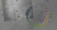
 Here's the aspect-slope map of the same area as before (Victoria is left of centre at the top), made in exactly the same way as suggested in Micael's link.
It looks good, but I'm not sure that it helps too much in figuring out what we can see in the distance (due to resolution of DEM etc...). Hmmm, I wonder what else I can use Arc for now... Pete |
|
 |
 
|
|
|
Feb 24 2010, 03:55 PM
Post
#122
|
|
|
Member Group: Senior Member Posts: 136 Joined: 8-August 06 Member No.: 1022 |
QUOTE (pgrindrod @ Feb 24 2010, 01:06 AM)  Well I had a pop at the viewshed before, but was kind of limited by the DEM I was using (75 m/px HRSC), and the fact that I hadn't lifted the view off the ground. Pete Using the HRSC DEM is an excellent idea at low latitude sites, since the MOLA ground tracks can be a couple of kilometers apart at the equator. I've experimented with this data in other places, but not at Opportunity. I'll have to take a look at it, as the 75m spatial resolution is considerably better than the MOLA coverage there. -Tim. |
|
|
|
|
Feb 24 2010, 05:33 PM
Post
#123
|
|||
|
Junior Member Group: Members Posts: 59 Joined: 18-July 07 From: London, UK Member No.: 2873 |
Yep, the HRSC DEM is good, but I'd still like a CTX one
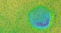
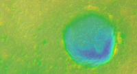
Just to show what the underlying DEM looks like for all these viewsheds, here's a couple of coloured hillshades with contours (one with labels, one without). I haven't done anything fancy to make the contours, just whatever the default settings are in Arc. The green dot is Opportunity a few weeks ago.
Pete |
||
|
|
|
||
|
Feb 24 2010, 09:09 PM
Post
#124
|
|
 Member Group: Members Posts: 267 Joined: 5-February 06 Member No.: 675 |
QUOTE (pgrindrod @ Feb 24 2010, 04:06 AM) These don't take the curvature of the planet into consideration, as there's no easy way (to my knowledge) of changing the radius to that of Mars rather than the Earth (apart from fooling Arc with the original projection etc.). And switching on the curvature just for the hell of it does seem to make quite a difference in terms of what's visible on the horizon; that effect could be even greater for Mars then. I recall reading many years ago that if you tweak the refraction parameter appropriately, you can fool Arc about the radius of the planet. Sorry I can't give you a reference on that. Steve M After checking Google I found details on the ArcGIS help page. |
|
|
|
|
Feb 24 2010, 10:23 PM
Post
#125
|
|
|
Member Group: Senior Member Posts: 136 Joined: 8-August 06 Member No.: 1022 |
Back in the olden days, before we had MOLA topography, and back when I was trying to anticipate what we might be able to see after Pathfinder landed, I looked at the visibility of distant objects at the Viking landing sites and realized that local topography is more important than the size of the planet, and submitted this abstract to LPSC:
-Tim.
Attached File(s)
|
|
|
|
|
Feb 25 2010, 09:06 PM
Post
#126
|
|
 The Poet Dude Group: Moderator Posts: 5551 Joined: 15-March 04 From: Kendal, Cumbria, UK Member No.: 60 |
Very nice view of the distant hills today...
http://qt.exploratorium.edu/mars/opportuni...CXP2378L6M2.JPG -------------------- |
|
|
|
|
Feb 25 2010, 09:17 PM
Post
#127
|
|
 Senior Member Group: Members Posts: 1089 Joined: 19-February 05 From: Close to Meudon Observatory in France Member No.: 172 |
QUOTE (tim53 @ Feb 24 2010, 11:23 PM) Back in the olden days, before we had MOLA topography, and back when I was trying to anticipate what we might be able to see after Pathfinder landed.... -Tim. Tim, I remember this paper very well and we had then a discussion with Cheick Diarra about the implications of seeing distant features and reprensenting them on maps for large public audience for the sake of our future Mars Outreach... |
|
|
|
|
Feb 26 2010, 01:06 AM
Post
#128
|
||
|
Solar System Cartographer Group: Members Posts: 10226 Joined: 5-April 05 From: Canada Member No.: 227 |
Stu pointed to this image - here's a bit of a vertical stretch of it.
Phil
-------------------- ... because the Solar System ain't gonna map itself.
Also to be found posting similar content on https://mastodon.social/@PhilStooke Maps for download (free PDF: https://upload.wikimedia.org/wikipedia/comm...Cartography.pdf NOTE: everything created by me which I post on UMSF is considered to be in the public domain (NOT CC, public domain) |
|
|
|
|
|
|
Feb 26 2010, 01:23 AM
Post
#129
|
|
|
Member Group: Members Posts: 267 Joined: 5-February 06 Member No.: 675 |
QUOTE (Phil Stooke @ Feb 25 2010, 08:06 PM) Stu pointed to this image - here's a bit of a vertical stretch of it. Phil I have a question for the image processing whiz kids here. I've filtered the region above the horizon line with the standard 2d median in photoshop, which does a good job of removing the compression noise but smears the mountain peaks and valleys. Since the brightness of the horizon profile increases (roughly) monotonically with increasing elevation, it seems that a median filter applied along segments of single vertical columns centered on the pixel of interest would remove much of the compression noise without distorting the image significantly. Is anyone able to implement such a filter and apply it to our horizon profiles? Steve M |
|
|
|
|
Feb 26 2010, 03:08 PM
Post
#130
|
||
|
Solar System Cartographer Group: Members Posts: 10226 Joined: 5-April 05 From: Canada Member No.: 227 |
I don't know about that... but here I've subtracted a high-pass-filtered version of the image above from the original. The HPF version was chosen to retain the small-scale mottling but suppress the rest. When it's subtracted this is what remains. A bit fuzzy but a lot cleaner.
Phil
-------------------- ... because the Solar System ain't gonna map itself.
Also to be found posting similar content on https://mastodon.social/@PhilStooke Maps for download (free PDF: https://upload.wikimedia.org/wikipedia/comm...Cartography.pdf NOTE: everything created by me which I post on UMSF is considered to be in the public domain (NOT CC, public domain) |
|
|
|
|
|
|
Feb 26 2010, 04:09 PM
Post
#131
|
||
 Senior Member Group: Members Posts: 4256 Joined: 17-January 05 Member No.: 152 |
Continuing to squeeze every bit of signal out of that L6 view of Iazu as possible, we have two versions of that image, M1 and M2. They are stretched quite differently, so the jpeg artifacts appear to be uncorrelated between them. So we can reduce the artifacts by averaging the two. Here's the result (after stretching the M1 version to match the M2), with 3x vertical stretch:
You can see that the bit on the right that was missing in M1 is noisier than the rest. A bit of smoothing happened during the rotation. |
|
|
|
|
|
|
Feb 26 2010, 06:49 PM
Post
#132
|
|
|
Solar System Cartographer Group: Members Posts: 10226 Joined: 5-April 05 From: Canada Member No.: 227 |
Very nice - I like those spiky hills at the right end.
Phil -------------------- ... because the Solar System ain't gonna map itself.
Also to be found posting similar content on https://mastodon.social/@PhilStooke Maps for download (free PDF: https://upload.wikimedia.org/wikipedia/comm...Cartography.pdf NOTE: everything created by me which I post on UMSF is considered to be in the public domain (NOT CC, public domain) |
|
|
|
|
Feb 26 2010, 10:06 PM
Post
#133
|
||
|
Member Group: Members Posts: 267 Joined: 5-February 06 Member No.: 675 |
Phil and Fred,
I didn't make myself clear, so here's a picture (worth a thousand words of clarification). This is a median filtered version of the original image, it nicely cleans up the compression artifacts but (as you can see) makes the peaks and valleys less jagged.
I think that if someone could implement a median that operated on vertical line segments (portions of a single column of the image) it would not round off the peaks and valleys and we could see them more clearly. Steve M |
|
|
|
|
|
|
Feb 27 2010, 01:01 PM
Post
#134
|
||
 Senior Member Group: Admin Posts: 3108 Joined: 21-December 05 From: Canberra, Australia Member No.: 615 |
This is certainly a view worth a little more tweaking.
Interesting to see the methods everyone is using.
|
|
|
|
|
|
|
Feb 27 2010, 01:22 PM
Post
#135
|
|
|
Solar System Cartographer Group: Members Posts: 10226 Joined: 5-April 05 From: Canada Member No.: 227 |
I understand exactly what you mean, Steve, I just don't know how to do it!
Phil -------------------- ... because the Solar System ain't gonna map itself.
Also to be found posting similar content on https://mastodon.social/@PhilStooke Maps for download (free PDF: https://upload.wikimedia.org/wikipedia/comm...Cartography.pdf NOTE: everything created by me which I post on UMSF is considered to be in the public domain (NOT CC, public domain) |
|
|
|
|

|
Lo-Fi Version | Time is now: 21st September 2024 - 08:46 PM |
|
RULES AND GUIDELINES Please read the Forum Rules and Guidelines before posting. IMAGE COPYRIGHT |
OPINIONS AND MODERATION Opinions expressed on UnmannedSpaceflight.com are those of the individual posters and do not necessarily reflect the opinions of UnmannedSpaceflight.com or The Planetary Society. The all-volunteer UnmannedSpaceflight.com moderation team is wholly independent of The Planetary Society. The Planetary Society has no influence over decisions made by the UnmannedSpaceflight.com moderators. |
SUPPORT THE FORUM Unmannedspaceflight.com is funded by the Planetary Society. Please consider supporting our work and many other projects by donating to the Society or becoming a member. |
|