Geomorphology of Cape York and Solander Point, Examining Opportunity's destination at Endeavour Crater |

  |
Geomorphology of Cape York and Solander Point, Examining Opportunity's destination at Endeavour Crater |
 Jul 19 2011, 06:32 PM Jul 19 2011, 06:32 PM
Post
#78
|
|
|
Member  Group: Members Posts: 362 Joined: 13-April 06 From: Malta Member No.: 741 |
I am no planetary geologist and therfore may not be knowledgable to answer such queries but I think that CY forms part of endeavour crater rim and thus represents material excavated from deeper layers on Mars which presumably contain the clays which predate the sulphates!
|
 |
 
|
|
Jul 19 2011, 06:56 PM
Post
#79
|
|
 Senior Member Group: Members Posts: 2173 Joined: 28-December 04 From: Florida, USA Member No.: 132 |
QUOTE (Julius @ Jul 19 2011, 01:32 PM)  ... I think that CY forms part of endeavour crater rim and thus represents material excavated from deeper layers... Yes, but at one point the sulphate layers covered Cape York. They have been eroded away so I would expect to find blueberries that eroded out of the sulphate layers on Cape York but I would expect little left of the Sulphate layers themselves. As for why the Meridiani plains leading up to Cape York are higher, I guess it's just a matter of differential erosion rates due to the prevailing winds over the topography of the crater.
|
|
|
|
|
Jul 19 2011, 07:14 PM
Post
#80
|
|
|
Junior Member Group: Members Posts: 53 Joined: 5-October 06 Member No.: 1227 |
QUOTE (centsworth_II @ Jul 19 2011, 10:56 AM) Yes, but at one point the sulphate layers covered Cape York. They have been eroded away so I would expect to find blueberries that eroded out of the sulphate layers on Cape York but I would expect little left of the Sulphate layers themselves. This is quite plausable. In this case we should see a blueberry lag deposit directly on the clays (ie the sulfates are all gone in places). Blueberries over clays (and other CY rim materials) would look different than blueberries over sulfates & sands (which we are driving on) and would explain why CY is destinctive looking even though it is lower than the plains. |
|
|
|
|
Jul 19 2011, 08:22 PM
Post
#81
|
|
|
Member Group: Members Posts: 507 Joined: 10-September 08 Member No.: 4338 |
There has been no mention of a hematite signature from Cape York. Wouldn't a blueberry lag deposit produce such a signature?
|
|
|
|
|
Jul 19 2011, 09:15 PM
Post
#82
|
|
|
Solar System Cartographer Group: Members Posts: 10166 Joined: 5-April 05 From: Canada Member No.: 227 |
The CRISM composition data certainly don't seem to point to a blueberry layer on Cape York... but it's certainly legitimate to ask why not, if the whole area was covered with the plains material and it has eroded away. One possible explanation - blueberries were more common in some areas than in others, and this may be an area where they were not found to begin with. Test - look for blueberries in the plains immediately adjacent to the Cape.
Phil -------------------- ... because the Solar System ain't gonna map itself.
Also to be found posting similar content on https://mastodon.social/@PhilStooke Maps for download (free PD: https://upload.wikimedia.org/wikipedia/comm...Cartography.pdf NOTE: everything created by me which I post on UMSF is considered to be in the public domain (NOT CC, public domain) |
|
|
|
|
Jul 19 2011, 11:00 PM
Post
#83
|
|
|
Junior Member Group: Members Posts: 53 Joined: 5-October 06 Member No.: 1227 |
QUOTE (Phil Stooke @ Jul 19 2011, 01:15 PM) The CRISM composition data certainly don't seem to point to a blueberry layer on Cape York... If that is indeed the case, ie no berries/sulfates on CY while berries are [presumably] on the plains right around CY, then we have a head scratcher here and this might point more towards a groundwater source of the sulfate/hematite instead of an evaporated body of water (which would have had to have covered CY since CY is lower than the surrounding plains) as I proposed in my original post. Note: I am not a Geologist, but my dad is... :-) -Ben- |
|
|
|
|
Jul 19 2011, 11:20 PM
Post
#84
|
|
|
Member Group: Members Posts: 507 Joined: 10-September 08 Member No.: 4338 |
QUOTE (bgarlick @ Jul 19 2011, 04:00 PM) (which would have had to have covered CY since CY is lower than the surrounding plains) That might not follow. Flood waters pouring over a cliff will take the path of least resistance, and will avoid locally higher obstacles. It is only if the entire area was submerged that CY would necessarily have been covered. |
|
|
|
|
Jul 19 2011, 11:58 PM
Post
#85
|
|
 Senior Member Group: Members Posts: 4247 Joined: 17-January 05 Member No.: 152 |
QUOTE (Phil Stooke @ Jul 19 2011, 09:15 PM) it's certainly legitimate to ask why not, if the whole area was covered with the plains material and it has eroded away Perhaps the berries rolled downhill into Endeavour, assisted by winds?Moderators: perhaps this discussion should be moved to the "Geomorphology of Cape York" thread? |
|
|
|
|
Jul 20 2011, 12:34 AM
Post
#86
|
|
|
Senior Member Group: Members Posts: 1044 Joined: 17-February 09 Member No.: 4605 |
The topography inside Endeavour would seem to indicate that the sediments flowed into the crater from the NW. The contours also seem to indicate a slightly steeper channel just to the south of CY. It is pretty clear that the blueberries formed within the sediments and whether there was just groundwater or whether there was a surface water overlay would seem immaterial. Low profile notwithstanding the feature is fascinating, but concentrating on the geomorphology of Cape York in isolation rather than standing back and considering it in the context of Endeavour Crater as a whole could be a bit limiting.
|
|
|
|
|
Jul 20 2011, 01:23 AM
Post
#87
|
|
 Member Group: Members Posts: 714 Joined: 3-January 08 Member No.: 3995 |
.
|
|
|
|
|
Jul 20 2011, 03:32 PM
Post
#88
|
||
|
Senior Member Group: Members Posts: 2173 Joined: 28-December 04 From: Florida, USA Member No.: 132 |
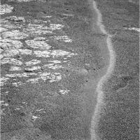
QUOTE (Phil Stooke @ Jul 19 2011, 05:15 PM) The CRISM composition data certainly don't seem to point to a blueberry layer on Cape York... ...Test - look for blueberries in the plains immediately adjacent to the Cape. This Pancam from sol 2658, about 1200 meters from Cape York, shows plenty of berries.
Does CRISM really show no hematite signal from Cape York, or is it just that that is not where the focus of attention is at? Phyllosilicate and hydrated sulphates are the focus, but does that mean the hematite is not there or just not being talked about? I think I will be more surprised to see few berries on Cape York than many. Just because I think The Cape was covered by the same berry containing layers that eroded away and left berries over the rest of Oppy's route. But maybe berry forming layers never did extend over Cape York. It will be interesting to see. |
|
|
|
|
|
|
Jul 20 2011, 03:59 PM
Post
#89
|
||
|
Senior Member Group: Members Posts: 2173 Joined: 28-December 04 From: Florida, USA Member No.: 132 |
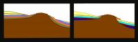
QUOTE (Gladstoner @ Jul 19 2011, 09:23 PM) Two interpretations of the terraces of Cape York: I hope you don't mind my fooling with your diagrams to better reflect the elevation between Cape York and the adjacent plains. (I'm sure Phil would do it if he had the time.  ) )
|
|
|
|
|
|
|
Jul 20 2011, 06:44 PM
Post
#90
|
|
|
Member Group: Members Posts: 714 Joined: 3-January 08 Member No.: 3995 |
.
|
|
|
|
|
Jul 21 2011, 12:12 AM
Post
#91
|
|
|
Member Group: Members Posts: 714 Joined: 3-January 08 Member No.: 3995 |
.
|
|
|
|
|
Jul 21 2011, 01:05 AM
Post
#92
|
|
 Senior Member Group: Moderator Posts: 2785 Joined: 10-November 06 From: Pasadena, CA Member No.: 1345 |
I think I like your very first diagram the best (post 87 here). It explains the similar unit at the margin surrounding the central material of the ancient rim.
I'm not sure how I see that the interior layers could get bent to follow the crater interior. The initial whack should've gouged a big hole, and any layers that formed afterwards should have been dropped in parallel and flat. Any tilting after that would be uniform across the region...and you should see that as a difference in remnant rim heights. -------------------- Some higher resolution images available at my photostream: http://www.flickr.com/photos/31678681@N07/
|
|
|
|
|

|
Lo-Fi Version | Time is now: 24th May 2024 - 11:13 PM |
|
RULES AND GUIDELINES Please read the Forum Rules and Guidelines before posting. IMAGE COPYRIGHT |
OPINIONS AND MODERATION Opinions expressed on UnmannedSpaceflight.com are those of the individual posters and do not necessarily reflect the opinions of UnmannedSpaceflight.com or The Planetary Society. The all-volunteer UnmannedSpaceflight.com moderation team is wholly independent of The Planetary Society. The Planetary Society has no influence over decisions made by the UnmannedSpaceflight.com moderators. |
SUPPORT THE FORUM Unmannedspaceflight.com is funded by the Planetary Society. Please consider supporting our work and many other projects by donating to the Society or becoming a member. |
|