On to Santa Maria! |

  |
On to Santa Maria! |
 Nov 18 2010, 06:31 AM Nov 18 2010, 06:31 AM
Post
#181
|
|
|
Merciless Robot  Group: Admin Posts: 8783 Joined: 8-December 05 From: Los Angeles Member No.: 602 |
Yeah, thought so, and sorry for even floating the concept. I must be twitchy today or something.
-------------------- A few will take this knowledge and use this power of a dream realized as a force for change, an impetus for further discovery to make less ancient dreams real.
|
 |
 
|
|
Nov 18 2010, 06:33 PM
Post
#182
|
|||
|
Junior Member Group: Members Posts: 59 Joined: 18-July 07 From: London, UK Member No.: 2873 |
I wasn't sure if this should go here, or in the route map thread, so please move if necessary.
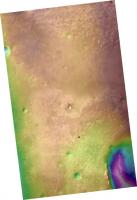
Here's a CTX DEM (20 m/px) of Oppy's driving area, made using the fantastic USGS scripts (thanks!) and the old SocetSet pulling-out-your-hair method. Actually, CTX DEMs seem (famous last words) to be working pretty well...there must be something wrong.  First up, a general elevation colour map with CTX image P01_001612_1780_XI_02S005 underneath. The red dot is Oppy on sol 2420, taken from Tesheiner's route map (thanks!).
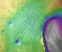
Next, a close-up view of Oppy and the rim of Endeavour, this time with a different colour stretch to highlight the elevation change on the next part of the route.
I'm more than happy to share this if anybody thinks they can do something with it. Pete |
||
|
|
|
||
|
Nov 18 2010, 06:47 PM
Post
#183
|
|
|
Founder Group: Chairman Posts: 14432 Joined: 8-February 04 Member No.: 1 |
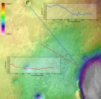
Could you pull out a height profile, from - say, Victoria to the edge of Endeavour including the rim? and/or from our current location to the rim at Cape York. That sort of thing
|
|
|
|
|
Nov 18 2010, 07:43 PM
Post
#184
|
|
 Senior Member Group: Members Posts: 4246 Joined: 17-January 05 Member No.: 152 |
Thanks for this! Can you provide an elevation scale for these images as well?
|
|
|
|
|
Nov 18 2010, 10:09 PM
Post
#185
|
||
 Senior Member Group: Admin Posts: 3108 Joined: 21-December 05 From: Canberra, Australia Member No.: 615 |
Whenever I see images like this one, I can't help but think of images like this one....Endeavour Bound!!!
|
|
|
|
|
|
|
Nov 19 2010, 12:55 AM
Post
#186
|
|
|
Member Group: Members Posts: 166 Joined: 20-September 05 From: North Texas Member No.: 503 |
Land Ho!
Wait a minute. Those islands are off the stern. You're sailing the wrong direction Astro0! It's amazing though, how a change of color in those ripples completely changes what the brain thinks it's seeing. David |
|
|
|
|
Nov 19 2010, 02:37 AM
Post
#187
|
|
 Senior Member Group: Moderator Posts: 3431 Joined: 11-August 04 From: USA Member No.: 98 |
QUOTE (DFinfrock @ Nov 18 2010, 05:55 PM)  Wait a minute. Those islands are off the stern. Yo'ure sailing the wrong direction Astro0! Off the port side, actually 
|
|
|
|
|
Nov 19 2010, 03:03 AM
Post
#188
|
|
|
Senior Member Group: Admin Posts: 3108 Joined: 21-December 05 From: Canberra, Australia Member No.: 615 |
DFinfrock: You're sailing the wrong direction Astro0!
No, just a leisurely voyage tacking across the Meridiani 'sea'
|
|
|
|
|
Nov 19 2010, 03:27 AM
Post
#189
|
|
|
Senior Member Group: Members Posts: 4246 Joined: 17-January 05 Member No.: 152 |
It looks like the hazcam-less drive has taken place:
http://qt.exploratorium.edu/mars/opportuni...0M1.JPG?sol2424 |
|
|
|
|
Nov 19 2010, 07:28 AM
Post
#190
|
|
|
Senior Member Group: Moderator Posts: 4279 Joined: 19-April 05 From: .br at .es Member No.: 253 |
130m, according to the rover's mobility data.
|
|
|
|
|
Nov 19 2010, 10:05 AM
Post
#191
|
||
|
Junior Member Group: Members Posts: 59 Joined: 18-July 07 From: London, UK Member No.: 2873 |
As requested, but I'd avoid reading too much into the actual profiles and the spikes and troughs - there's a fair bit of noise in this DEM as the smooth terrain is great for driving but bad for pixel matching! It does however still give a nice impression of the overall topography.
Pete |
|
|
|
|
|
|
Nov 19 2010, 10:08 AM
Post
#192
|
|
|
Senior Member Group: Members Posts: 2920 Joined: 14-February 06 From: Very close to the Pyrénées Mountains (France) Member No.: 682 |
The mean mileage per sol is consistantly increasing since late August but the more the sols the more the "need" to drive to keep it this way (at least 250m per week at the moment). So, I guess we're "safe" this week
 Not a race but giving the feeling that we follow SS statement. -------------------- |
|
|
|
|
Nov 19 2010, 10:56 AM
Post
#193
|
|
 Senior Member Group: Moderator Posts: 2262 Joined: 9-February 04 From: Melbourne - Oz Member No.: 16 |
You can see (I think) in the red profile the same thing I had convinced myself from the MOLA data: That we are currently on a flattish section with a drop-off to Santa Maria a few hundred meters ahead. I think this is why we can't see Santa Maria yet.
I made a prediction to Stu by PM earlier this week regarding this: That I expected Santa Maria to pop into view quite suddenly and dramatically ~400m ahead, since then we have covered around half that distance. So keep your eyes pealed over the next few drives, I'm anticipating a HOAV moment very soon. James -------------------- |
|
|
|
|
Nov 20 2010, 08:28 PM
Post
#194
|
|||
|
Senior Member Group: Members Posts: 4246 Joined: 17-January 05 Member No.: 152 |
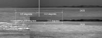
I've made some measurements to try to decide whether the double feature we've been seeing is Santa Maria or not. I compared the separations and positions (relative to the distant east rim of Endeavour) of both of the light "bumps" on sols 2409 and 2420. These measurements are entirely relative, ie I didn't use any absolute heading information. The only assumption is for the comparison of bump positions between 2409 and 2420: I assumed that the distant east rim of Endeavour was essentially infinitely far away, so there was no parallax between 2409 and 2420 of that east rim. That parallax should be extremely small. The left-right bump separation measurements are independent of this assumption.
Here are the angles measured from the pancams:
And here are the corresponding angles measured from Tesheiner's route map:
The corresponding angles are consistent with each other, if the two bumps are high points on the north and south rim of Santa Maria. The agreement of the four angles means that both the size and distance agree with Santa Maria. So I'm ready to declare that the two light bumps are Santa Maria. |
||
|
|
|
||
| Guest_Bobby_* |
Nov 21 2010, 04:24 AM
Post
#195
|
|
Guests |
I like your slide show presentation Fred K. I think we should be there by Christmas and what a gift to us all to see Santa Maria by then.
Maybe Santa Clause will stop by and give the Rover a boost of Energy for the coming season. I can remember the day she landed in Eagle Crater way back then or ages ago. I am amazed what this little golf cart rover has done. May The Force Be With Her. I do have a couple Question. Is the top of Santa Maria lower in elevation then the bottom of Victoria Crater and would the bedrock within Santa Maria be older then anything we saw at Victoria? Is there any possibility that we might go into Santa Maria or just drive around and keep going??? |
|
|
|
|

|
Lo-Fi Version | Time is now: 27th April 2024 - 03:49 PM |
|
RULES AND GUIDELINES Please read the Forum Rules and Guidelines before posting. IMAGE COPYRIGHT |
OPINIONS AND MODERATION Opinions expressed on UnmannedSpaceflight.com are those of the individual posters and do not necessarily reflect the opinions of UnmannedSpaceflight.com or The Planetary Society. The all-volunteer UnmannedSpaceflight.com moderation team is wholly independent of The Planetary Society. The Planetary Society has no influence over decisions made by the UnmannedSpaceflight.com moderators. |
SUPPORT THE FORUM Unmannedspaceflight.com is funded by the Planetary Society. Please consider supporting our work and many other projects by donating to the Society or becoming a member. |
|