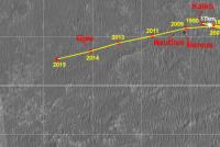
Opportunity Route Map |

  |
Opportunity Route Map |
 Sep 24 2009, 10:36 AM Sep 24 2009, 10:36 AM
Post
#2566
|
|
|
Senior Member  Group: Members Posts: 2920 Joined: 14-February 06 From: Very close to the Pyrénées Mountains (France) Member No.: 682 |
Very close to 18 kms, aren't we?
-------------------- |
 |
 
|
|
Sep 24 2009, 12:07 PM
Post
#2567
|
|
 Senior Member Group: Moderator Posts: 2262 Joined: 9-February 04 From: Melbourne - Oz Member No.: 16 |
Scott Maxwell tweeted that Oppy has just passed 11 miles. That would be 17.7km
-------------------- |
|
|
|
|
Sep 24 2009, 08:11 PM
Post
#2568
|
|
|
Senior Member Group: Moderator Posts: 4279 Joined: 19-April 05 From: .br at .es Member No.: 253 |
|
|
|
|
|
Sep 26 2009, 08:15 PM
Post
#2569
|
||
|
Senior Member Group: Moderator Posts: 4279 Joined: 19-April 05 From: .br at .es Member No.: 253 |
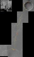
Sol 2017. Back on bedrock.
 Route_Map_Sol2017.kml ( 29.34K )
Number of downloads: 470
Route_Map_Sol2017.kml ( 29.34K )
Number of downloads: 470Is that small crater at the bottom left corner our next waypoint? |
|
|
|
|
|
|
Sep 27 2009, 07:45 PM
Post
#2570
|
|
|
Member Group: Members Posts: 713 Joined: 30-March 05 Member No.: 223 |
since departure from BI we made almost half a kilometer in 15 days !
one month = one kilometer: just the perfect Endeavour-Pace  ------------------------------ "Drive, Drive, Drive"... 
|
|
|
|
|
Sep 27 2009, 08:49 PM
Post
#2571
|
|
|
Senior Member Group: Moderator Posts: 4279 Joined: 19-April 05 From: .br at .es Member No.: 253 |
I love this pace too, but let's not forget the restricted sols.
|
|
|
|
|
Sep 30 2009, 01:39 PM
Post
#2572
|
||
|
Senior Member Group: Moderator Posts: 4279 Joined: 19-April 05 From: .br at .es Member No.: 253 |
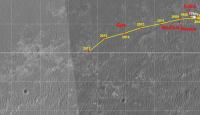
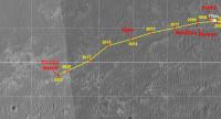
Here's the whole map, updated after sol 2020.
Route_Map_Sol2020.kml ( 29.56K )
Number of downloads: 454 |
|
|
|
|
|
|
Sep 30 2009, 02:36 PM
Post
#2573
|
|
|
Senior Member Group: Members Posts: 2920 Joined: 14-February 06 From: Very close to the Pyrénées Mountains (France) Member No.: 682 |
3 sugestions (sorry no less)
+ add the 11 miles mark + add the 18 kms mark next drive (I know you'll do it  ) )+ once it'll come add the 10 kms mark in strait line from Eagle Edited: James mesured 9.06 kms from Eagle on Sol 1870, so, we're above 10 kms by now but not much more. -------------------- |
|
|
|
|
Sep 30 2009, 04:51 PM
Post
#2574
|
|
|
Senior Member Group: Moderator Posts: 4279 Joined: 19-April 05 From: .br at .es Member No.: 253 |
QUOTE (climber @ Sep 30 2009, 04:36 PM)  3 sugestions (sorry no less) + 1. add the 11 miles mark + 2. add the 18 kms mark next drive (I know you'll do it )+ 3. once it'll come add the 10 kms mark in strait line from Eagle Edited: James mesured 9.06 kms from Eagle on Sol 1870, so, we're above 10 kms by now but not much more. 1. Well, I didn't include the 10 mile stone or previous ones so ... 2. If this drive adds another 70m to the odometer, yes.  3. I like the idea; actually the grid --squares each 100m-- gives almost all is needed to do it. The problem is that the grid origin in my map is the exit from VC, not Eagle, and it should be offset before adding labels (e.g. 5km, 10km) to the grid. Let's see what I can do. |
|
|
|
|
Sep 30 2009, 06:35 PM
Post
#2575
|
||
 Member Group: Members Posts: 813 Joined: 8-February 04 From: Arabia Terra Member No.: 12 |
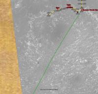
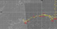
Opportunity has a fair way to go before they are again as near to Endeavour as they were on sol 1927. Once they cross the green line in this image, they'll be closer.
Attached thumbnail(s)
|
|
|
|
|
|
|
Sep 30 2009, 09:59 PM
Post
#2576
|
|
|
Member Group: Members Posts: 530 Joined: 21-March 06 From: Canada Member No.: 721 |
Oh cool, thanks SFJCody! I've been wondering where the "detour" ended.
|
|
|
|
|
Oct 2 2009, 04:55 PM
Post
#2577
|
|
|
Senior Member Group: Moderator Posts: 4279 Joined: 19-April 05 From: .br at .es Member No.: 253 |
|
|
|
|
|
Oct 14 2009, 09:20 AM
Post
#2578
|
||
|
Senior Member Group: Moderator Posts: 4279 Joined: 19-April 05 From: .br at .es Member No.: 253 |
It's time to go "back to business".
Here's a map update after sol 2034, including the 18km mark (Hi climber!) which was crossed in this sol. The grid has been updated too; check my previous entry four posts above for more details.
Route_Map_Sol2034.kml ( 31.01K )
Number of downloads: 443 |
|
|
|
|
|
|
Oct 14 2009, 09:59 AM
Post
#2579
|
|
 The Poet Dude Group: Moderator Posts: 5551 Joined: 15-March 04 From: Kendal, Cumbria, UK Member No.: 60 |
Farewell Shelter Island, nice knowing you...
Can I just thank you for taking the time to make those Google Earth files, Tesh? Don't know about anyone else, but it's adding a whole new dimension to Oppy's Great Trek for me... -------------------- |
|
|
|
|
Oct 14 2009, 02:09 PM
Post
#2580
|
|
|
Member Group: Members Posts: 128 Joined: 28-October 08 From: Boston, MA Member No.: 4469 |
I agree completely, Stu. I especially appreciate the attention to the small hops in Google Earth that wouldn't register on the JPG map.
Regarding the JPG map, I do have one request. Now that the grid has been changed, can you post an update of the whole map going back to Victoria? I overlay your daily map snippets on the latest big map every time you post them, but now the grid lines don't coincide anymore. (Am I the only one who does this...?) Thanks, Eduardo, and thanks for all your tireless work in maintaining this thread. |
|
|
|
|

|
Lo-Fi Version | Time is now: 25th April 2024 - 01:21 PM |
|
RULES AND GUIDELINES Please read the Forum Rules and Guidelines before posting. IMAGE COPYRIGHT |
OPINIONS AND MODERATION Opinions expressed on UnmannedSpaceflight.com are those of the individual posters and do not necessarily reflect the opinions of UnmannedSpaceflight.com or The Planetary Society. The all-volunteer UnmannedSpaceflight.com moderation team is wholly independent of The Planetary Society. The Planetary Society has no influence over decisions made by the UnmannedSpaceflight.com moderators. |
SUPPORT THE FORUM Unmannedspaceflight.com is funded by the Planetary Society. Please consider supporting our work and many other projects by donating to the Society or becoming a member. |
|