Cape York - Shoemaker Ridge and the NE traverse, Starting sol 2735 |

  |
Cape York - Shoemaker Ridge and the NE traverse, Starting sol 2735 |
 Oct 30 2011, 09:17 PM Oct 30 2011, 09:17 PM
Post
#301
|
|
|
Senior Member  Group: Members Posts: 3516 Joined: 4-November 05 From: North Wales Member No.: 542 |
Because of the eccentricity the equatorial regions share the southern hemisphere's seasons, approximately. Presumably this would still be true if we were at 2 degrees north (taking seasons as being defined by insolation rather than in the strict astronomical/geometrical sense.) Does anybody know the northerly latitude at which the effects balance out - the 'weather equator' so to speak?
|
 |
 
|
|
Oct 31 2011, 03:59 AM
Post
#302
|
|
 Senior Member Group: Members Posts: 2228 Joined: 1-December 04 From: Marble Falls, Texas, USA Member No.: 116 |
QUOTE (marsophile @ Oct 28 2011, 07:01 PM)  I think what he means is something like a West-North-West slope of 40 degrees, as an extreme example. The northward component of that might be about 20 degrees, which might be great for power considerations, but the total slope of 40 degrees might be unsafe for the rover. CosmicRocker, sorry if I am putting words in your mouth! Thanks, marsophile. That's pretty much what I was talking about.  We were talking about slope components at that point. We were talking about slope components at that point.-------------------- ...Tom
I'm not a Space Fan, I'm a Space Exploration Enthusiast. |
|
|
|
|
Oct 31 2011, 08:46 AM
Post
#303
|
||
|
Senior Member Group: Moderator Posts: 4279 Joined: 19-April 05 From: .br at .es Member No.: 253 |
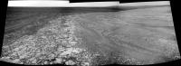
QUOTE (fredk @ Oct 30 2011, 05:35 PM) If anyone's curious why we've drifted to the western "shore" of CY, I think there's a strong clue in the recent updates: They're on the lookout for veins of light-toned material, like we saw near the "shore" after our first drive onto CY. The favourable slope region is just a day or two's drive to the E or NE, so I guess we've got the time (and power) to see what's nearby. My guess is we'll now explore more of the "coastline" and the interior of CY. Here's a crude mosaic of the today's navcams where I circled two possible veins.
|
|
|
|
|
|
|
Oct 31 2011, 09:37 AM
Post
#304
|
|
|
Senior Member Group: Members Posts: 2998 Joined: 30-October 04 Member No.: 105 |
Yes, and if you'll look to the left of the upper "light vein" you'll see a dark (shadowed??) "fin" as well as similarly-trending lineations in the fractured light-toned area.
--Bill -------------------- |
|
|
|
|
Oct 31 2011, 11:57 AM
Post
#305
|
||
 Dublin Correspondent Group: Admin Posts: 1799 Joined: 28-March 05 From: Celbridge, Ireland Member No.: 220 |
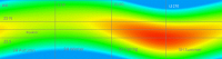
QUOTE (ngunn @ Oct 30 2011, 10:17 PM) Does anybody know the northerly latitude at which the effects balance out - the 'weather equator' so to speak? This article from MSSS goes into a lot of detail and has a really nice visual that shows the variation in insolation by latitude over a martian year, I've added some quidelines (with southern seasons) here to make it easier to see approximate latitudes and time of the year.
This shows peak insolation at noon not total insolation, the article discusses a lot of the secondary effects (such as atmospheric pressure) which also shows how dominant the eccentricity is for Martian Climate. I don't have an index for the colours used but solar insolation above the atmosphere at LS 270 is ~ 650W/m^2 and at LS 90 it is about 545W/m^2. My reading of this is that to counteract the effects of eccentricity you would appear to have to go quite far north of the tropics before you would have a Northern location that actually tracked "Northern" seasons in any meaningful way. The deviation of maximimum\minimum insolation levels from the solstices is very apparent here, especially as you reach tropical latitudes. There are other things to factor in - most notably dust levels. There is a clear trend there for both MER locations, and I guess across all of the planet at least between the tropics, that tracks the SH seasonal changes: dustier in late SH spring\summer, clearer in SH winter. |
|
|
|
|
|
|
Oct 31 2011, 03:21 PM
Post
#306
|
|||
 Senior Member Group: Moderator Posts: 3431 Joined: 11-August 04 From: USA Member No.: 98 |
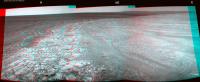
Sol 2761 anaglyphs
Attached thumbnail(s)
|
||
|
|
|
||
|
Oct 31 2011, 04:18 PM
Post
#307
|
|
 Member Group: Members Posts: 267 Joined: 5-February 06 Member No.: 675 |
QUOTE (helvick @ Oct 31 2011, 06:57 AM) This article from MSSS goes into a lot of detail and has a really nice visual that shows the variation in insolation by latitude over a martian year, I've added some quidelines (with southern seasons) here to make it easier to see approximate latitudes and time of the year. trimmed long quote -mod Near the tropics (where Opportunity is) this diagram covers the primary effect quite well. For northern and southern latitudes, where length of daylight effects begin to predominate, the diagram would have to be modified significantly. Steve M |
|
|
|
|
Oct 31 2011, 06:03 PM
Post
#308
|
|
|
Junior Member Group: Members Posts: 98 Joined: 17-July 11 From: Pasadena, CA Member No.: 6066 |
QUOTE (Greg Hullender @ Oct 30 2011, 10:46 AM) Since Opportunity is just two degrees from the equator, why is anyone talking about winter? I would think aphelion would be far more significant. --Greg We account for both, of course. The difference is, we can control tilt (insofar as we can find geography with good tilts!). The orbit eccentricity is a fixed constraint, something we can't change. -m |
|
|
|
|
Oct 31 2011, 06:54 PM
Post
#309
|
|
|
Member Group: Members Posts: 910 Joined: 4-September 06 From: Boston Member No.: 1102 |
The ideal spot for Oppy would be a half pipe running North/South with a slight Northern tilt. Then in the morning she could climb the left wall and tilt East, and in the evening move a few feet to the right wall and tilt West. A fully sun tracking rover with her panels always facing the sun
 -------------------- |
|
|
|
|
Oct 31 2011, 07:02 PM
Post
#310
|
|
 Senior Member Group: Members Posts: 4246 Joined: 17-January 05 Member No.: 152 |
Exactly! Basking lizard-style!

|
|
|
|
|
Oct 31 2011, 08:01 PM
Post
#311
|
|
|
Senior Member Group: Members Posts: 3516 Joined: 4-November 05 From: North Wales Member No.: 542 |
QUOTE (helvick @ Oct 31 2011, 11:57 AM) My reading of this is that to counteract the effects of eccentricity you would appear to have to go quite far north of the tropics before you would have a Northern location that actually tracked "Northern" seasons in any meaningful way. An excellent diagram, even if it maps only one relevant parameter. Assuming that factor dominates between the tropics I'd say the 'weather equator' runs close to 20N. 25N is greenest at LS 270, 15N is greenest around LS 90. So: land a probe at 20N to avoid seasonal blues! |
|
|
|
|
Oct 31 2011, 09:12 PM
Post
#312
|
|
|
Dublin Correspondent Group: Admin Posts: 1799 Joined: 28-March 05 From: Celbridge, Ireland Member No.: 220 |
As SteveM pointed out this really only maps out one parameter and a better map would show total insolation not just the peak value. One other point that should be mapped at the same time would be average Tau and its effect on direct and indirect sunlight - while NH winters are less severe they are also dustier.
A hypothetical MER at (say) 14 deg N would have less severe winters (with more potential noon sunlight at least) than Spirit but it would happen when Tau was generally quite high so there would almost certainly be less incident energy, possibly a lot less. One further complication of this is that higher Tau decreases direct sunlight but increases diffuse sunlight so Southerly facing Winter Haven's and lilly pads would be a lot less effective. I suspect that the net effect would be that deep winter survive-ability would be much more of a challenge. |
|
|
|
|
Oct 31 2011, 10:14 PM
Post
#313
|
|
|
Member Group: Members Posts: 910 Joined: 4-September 06 From: Boston Member No.: 1102 |
-------------------- |
|
|
|
|
Oct 31 2011, 10:40 PM
Post
#314
|
|
|
Senior Member Group: Members Posts: 3516 Joined: 4-November 05 From: North Wales Member No.: 542 |
QUOTE (helvick @ Oct 31 2011, 09:12 PM) A hypothetical MER at (say) 14 deg N OK I promise to stop this OT discussion soon! but your latest post leaves me confused. Which winters would be a problem at 14N, northern winters or southern ones? You seem to refer to both as winter?? Taking tau, daylength, everything into consideration what's your best estimate for the latitude on Mars that receives 'even seasons' insolation-wise? (That's what I mean by the 'weather equator'.) |
|
|
|
|
Oct 31 2011, 11:12 PM
Post
#315
|
||
|
Senior Member Group: Members Posts: 2998 Joined: 30-October 04 Member No.: 105 |
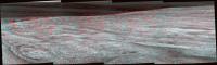
And here is a vertical perspective panorama of the onlap area on Sol-2761, showing the light-toned "vein" and the razorback and lineations on the exposed bedrock.
--Bill
Attached thumbnail(s)
-------------------- |
|
|
|
|
|
|

|
Lo-Fi Version | Time is now: 23rd April 2024 - 04:12 PM |
|
RULES AND GUIDELINES Please read the Forum Rules and Guidelines before posting. IMAGE COPYRIGHT |
OPINIONS AND MODERATION Opinions expressed on UnmannedSpaceflight.com are those of the individual posters and do not necessarily reflect the opinions of UnmannedSpaceflight.com or The Planetary Society. The all-volunteer UnmannedSpaceflight.com moderation team is wholly independent of The Planetary Society. The Planetary Society has no influence over decisions made by the UnmannedSpaceflight.com moderators. |
SUPPORT THE FORUM Unmannedspaceflight.com is funded by the Planetary Society. Please consider supporting our work and many other projects by donating to the Society or becoming a member. |
|