MSL Post Landing - Commissioning Period & Early Observations, Commissioning Activity Period 1B - Sols 9 through 16 |

  |
MSL Post Landing - Commissioning Period & Early Observations, Commissioning Activity Period 1B - Sols 9 through 16 |
 Aug 20 2012, 10:50 AM Aug 20 2012, 10:50 AM
Post
#101
|
|
|
Senior Member  Group: Members Posts: 2922 Joined: 14-February 06 From: Very close to the Pyrénées Mountains (France) Member No.: 682 |
QUOTE (belleraphon1 @ Aug 19 2012, 11:58 PM)  "It's surprising that the data are even better than we ever had during tests on Earth, in signal-to-noise ratio," Does somedody know if ChemCam was ever tested in a simulated Martian atmosphere? can't find any answer myself. -------------------- |
 |
 
|
|
Aug 20 2012, 11:04 AM
Post
#102
|
|
|
Member Group: Members Posts: 153 Joined: 4-May 11 From: Pardubice, CZ Member No.: 5979 |
QUOTE (orgetorix @ Aug 19 2012, 07:31 PM) Looking in the lower-right quadrant of the lower-left quadrant: that roundel with the JPL logo on it: is this post-flight damage? Or was that scar there before launch? Nope It's not any damage. The background of JPL logo is our Sun (I guess) with planets on their orbits, see this picture. |
|
|
|
|
Aug 20 2012, 11:21 AM
Post
#103
|
|||
 Senior Member Group: Members Posts: 1465 Joined: 9-February 04 From: Columbus OH USA Member No.: 13 |
QUOTE (MichaelJWP @ Aug 20 2012, 05:29 AM) Basically is there anywhere JPL posts a "sol-by-sol" list of what's planned in terms of surface operations for Curiosity for the next few sols? The mother lode would be the MSLICE software they use internally for mission planning:
Wouldn't hold my breath for that one though! It's interesting that that the Cassini mission puts their science plans on the public NAIF website, encoded as "event kernels." That's kind of rare & maybe a reflection of the old school. The data include when exactly each image/measurement will be taken and for what purpose. -------------------- |
||
|
|
|
||
|
Aug 20 2012, 11:21 AM
Post
#104
|
|
|
Junior Member Group: Members Posts: 53 Joined: 15-July 09 Member No.: 4867 |
QUOTE (climber @ Aug 20 2012, 12:50 PM) Does somedody know if ChemCam was ever tested in a simulated Martian atmosphere? can't find any answer myself. Yes: http://www.dailymotion.com/video/xrmdgu_le...tech#from=embed at the 34th second. If you don't speak french, the gray "cannon" tube is where the Mars atmosphere is simulated (pressure, temperature and composition). |
|
|
|
|
Aug 20 2012, 11:47 AM
Post
#105
|
|
|
Junior Member Group: Members Posts: 27 Joined: 6-August 12 From: Leeds, Yorkshire, UK Member No.: 6469 |
Hello everyone. My first post, so a brief introduction. A newbie poster here, but a daily reader and lifelong spaceflight fan. I still have all the newspapers I collected as a boy when any space-related item appeared, from Sputnik to the moon landings. At 13, when I saw the first Mariner photos of Mars, I was utterly convinced that one day I would go there myself and have a good look around.
Well, all these years have passed, I've travelled far and wide but and I never did make it to Mars. And yet, thanks to NASA, JPL, guys like you and the wonders of the internet, I have indeed been to Mars. In fact, I go there every day and have a good look around, just like I always wanted. Thanks to Stu's excellent "Road to Endeavour" blog, I've followed Oppy every step of the way of her epic journey, and now I'm soaking up every detail of the fantastic, fascinating landscape of Gale Crater. Thank you, one and all. I am truly grateful. OK, enough romantic hogwash, I'll stick to science now I've said hello. Can anyone identify for me which mastcam raw image contains the target site of Glenelg? Using the following data I've walked the route on Google Mars and so I know the part of the panorama I should be looking at, but I'm uncertain as the exact location within a particular raw frame. Curi: 4°35'22.15"S, 137°26'30.00"E Glenelg: 4°35'24.00"S, 137°26'55.00"E (estimated) Antonb |
|
|
|
|
Aug 20 2012, 12:00 PM
Post
#106
|
||
|
Junior Member Group: Members Posts: 59 Joined: 18-July 07 From: London, UK Member No.: 2873 |
I'm not sure if this should be here or in the main landing thread (please move if necessary).
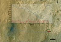
There was a bit of discussion about possible traverses. Well, of course, that'll depend on safety and science and we'll find out as we go along. But I thought I'd have a look at the relatively short (how times have changed!) drive of 400 m to the first drive target Glenelg.
(larger version on my website here) It looks like a gentle drop of about 20 m, with manageable slopes all less than about 8 degrees. Of course, this is just an example traverse plot, but it looks ok. For anybody interested, I wrote a blog post about my thoughts on the geological context of the landing site, including more of this GIS stuff, and how it might all fit into the story of Mars. Pete |
|
|
|
|
|
|
Aug 20 2012, 12:18 PM
Post
#107
|
|
|
Senior Member Group: Members Posts: 2922 Joined: 14-February 06 From: Very close to the Pyrénées Mountains (France) Member No.: 682 |
QUOTE (Lightning @ Aug 20 2012, 01:21 PM) Yes: http://www.dailymotion.com/video/xrmdgu_le...tech#from=embed at the 34th second. If you don't speak french, the gray "cannon" tube is where the Mars atmosphere is simulated (pressure, temperature and composition). Thanks! I AM French actually  ... ...
-------------------- |
|
|
|
|
Aug 20 2012, 12:20 PM
Post
#108
|
|
|
Senior Member Group: Members Posts: 2922 Joined: 14-February 06 From: Very close to the Pyrénées Mountains (France) Member No.: 682 |
QUOTE (pgrindrod @ Aug 20 2012, 02:00 PM) It looks like a gentle drop of about 20 m, Pete I remember John Grotzinger saying 2m. Did I misunderstood? -------------------- |
|
|
|
|
Aug 20 2012, 12:21 PM
Post
#109
|
|
|
Junior Member Group: Members Posts: 27 Joined: 6-August 12 From: Leeds, Yorkshire, UK Member No.: 6469 |
Pete, that's really interesting reading, thanks. I note that you calculate Glenelg is probably not visible on the panorama, but is it possible for you to plot the visible parts of your example traverse onto the mastcam panorama?
Antonb |
|
|
|
|
Aug 20 2012, 12:47 PM
Post
#110
|
|
|
Forum Contributor Group: Members Posts: 1372 Joined: 8-February 04 From: North East Florida, USA. Member No.: 11 |
QUOTE (climber @ Aug 20 2012, 01:20 PM) I remember John Grotzinger saying 2m. Did I misunderstood? I am pretty sure he said 20 m. |
|
|
|
|
Aug 20 2012, 01:04 PM
Post
#111
|
||
 Senior Member Group: Members Posts: 2173 Joined: 28-December 04 From: Florida, USA Member No.: 132 |
QUOTE (Antonb @ Aug 20 2012, 06:47 AM) ....Can anyone identify for me which mastcam raw image contains the target site of Glenelg? Have you seen Phil Stooke's interpretation in this post?
|
|
|
|
|
|
|
Aug 20 2012, 01:06 PM
Post
#112
|
|||
|
Senior Member Group: Members Posts: 1465 Joined: 9-February 04 From: Columbus OH USA Member No.: 13 |
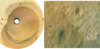
QUOTE (pgrindrod @ Aug 20 2012, 08:00 AM) There was a bit of discussion about possible traverses. Well, of course, that'll depend on safety and science and we'll find out as we go along. But I thought I'd have a look at the relatively short (how times have changed!) drive of 400 m to the first drive target Glenelg. FWIW, the Google Mars view (based on a MOLA DEM I think) shows that Glenelg is below a rise in the foreground:
So Glenelg would be on a bit of a slope. Should be a good view from there, almost like looking down into a valley:
Attached thumbnail(s)
-------------------- |
||
|
|
|
||
|
Aug 20 2012, 01:43 PM
Post
#113
|
||
|
Junior Member Group: Members Posts: 26 Joined: 7-August 12 Member No.: 6485 |
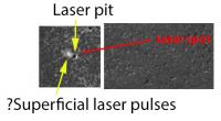
Set lasers to analyse!
They've done their first laser shot and posted a contextual image that's a differential of pre- and post-shot. Given that, I'm intrigued by the small scuff seen on the upper left of the pit. Roger Wiens was talking about their interest in seeing what the laser would reveal about rock coatings and surface interactions (34:53 in the telecon) - did they scatter a few pulses off the main pit to take a look?
Attached thumbnail(s)
|
|
|
|
|
|
|
Aug 20 2012, 02:50 PM
Post
#114
|
|
|
Junior Member Group: Members Posts: 27 Joined: 6-August 12 From: Leeds, Yorkshire, UK Member No.: 6469 |
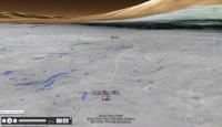
QUOTE (centsworth_II @ Aug 20 2012, 02:04 PM) Have you seen Phil Stooke's interpretation Yes, I saw that projection, which led me to believe the mastcam raw image containing Glenelg is this frame. I know Glenelg itself is hidden from Curi right now, but can anyone indicate the general area on this frame that we're heading for? Thanks. |
|
|
|
|
Aug 20 2012, 02:51 PM
Post
#115
|
|
 Senior Member Group: Moderator Posts: 2262 Joined: 9-February 04 From: Melbourne - Oz Member No.: 16 |
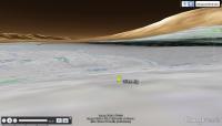
Looks like they imaged Mt Sharp with mastcam34 (and parts with mastcam100!) on sol 13. Thumbnails are avaiable.
http://mars.jpl.nasa.gov/msl/multimedia/raw/?s=13 -------------------- |
|
|
|
|

|
Lo-Fi Version | Time is now: 29th May 2024 - 06:30 PM |
|
RULES AND GUIDELINES Please read the Forum Rules and Guidelines before posting. IMAGE COPYRIGHT |
OPINIONS AND MODERATION Opinions expressed on UnmannedSpaceflight.com are those of the individual posters and do not necessarily reflect the opinions of UnmannedSpaceflight.com or The Planetary Society. The all-volunteer UnmannedSpaceflight.com moderation team is wholly independent of The Planetary Society. The Planetary Society has no influence over decisions made by the UnmannedSpaceflight.com moderators. |
SUPPORT THE FORUM Unmannedspaceflight.com is funded by the Planetary Society. Please consider supporting our work and many other projects by donating to the Society or becoming a member. |
|