MSL Post Landing - Commissioning Period & Early Observations, Commissioning Activity Period 1B - Sols 9 through 16 |

  |
MSL Post Landing - Commissioning Period & Early Observations, Commissioning Activity Period 1B - Sols 9 through 16 |
 Aug 20 2012, 03:36 PM Aug 20 2012, 03:36 PM
Post
#121
|
|||
 Senior Member  Group: Members Posts: 4256 Joined: 17-January 05 Member No.: 152 |
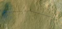
Here's my interpretation of Paolo's proposed route description:
And my guess for the outlines of the three terrain types around Glenelg:
As people have pointed out, it looks like the actual junction is hidden by the foreground. |
||
 |
 
|
||
|
Aug 20 2012, 03:41 PM
Post
#122
|
|
 Senior Member Group: Members Posts: 1619 Joined: 12-February 06 From: Bergerac - FR Member No.: 678 |
QUOTE (jamescanvin @ Aug 20 2012, 04:51 PM)  Looks like they imaged Mt Sharp with mastcam34 (and parts with mastcam100!) on sol 13. Thumbnails are avaiable. http://mars.jpl.nasa.gov/msl/multimedia/raw/?s=13 Are you sure for Mastcam100 ? Because this camera is located at the Right side of the Mast, not the Left. And all I see is "L" in the filenames. Maybe it's just subframed pictures ? -------------------- |
|
|
|
|
Aug 20 2012, 03:45 PM
Post
#123
|
|
 Senior Member Group: Members Posts: 3648 Joined: 1-October 05 From: Croatia Member No.: 523 |
QUOTE (Ant103 @ Aug 20 2012, 05:41 PM) Are you sure for Mastcam100 ? Definitely. See this thumbnail for example. -------------------- |
|
|
|
|
Aug 20 2012, 03:49 PM
Post
#124
|
|
 Forum Contributor Group: Members Posts: 1374 Joined: 8-February 04 From: North East Florida, USA. Member No.: 11 |
They moved Curiosities arm.
|
|
|
|
|
Aug 20 2012, 03:57 PM
Post
#125
|
|||
|
Member Group: Admin Posts: 976 Joined: 29-September 06 From: Pasadena, CA - USA Member No.: 1200 |
QUOTE (fredk @ Aug 20 2012, 08:36 AM) Here's my interpretation of Paolo's proposed route description:
And my guess for the outlines of the three terrain types around Glenelg:
As people have pointed out, it looks like the actual junction is hidden by the foreground. Correct, except that I'm not sure how close we will be driving to the halfway point and how close to the overlook point. And you are correct, Gleneleg is not visible from here. Maybe if we stick up the arm and take a MAHLI but I doubt we would be seeing it anyway. Paolo -------------------- Disclaimer: all opinions, ideas and information included here are my own,and should not be intended to represent opinion or policy of my employer.
|
||
|
|
|
||
|
Aug 20 2012, 04:02 PM
Post
#126
|
|
|
Senior Member Group: Members Posts: 1619 Joined: 12-February 06 From: Bergerac - FR Member No.: 678 |
QUOTE (ugordan @ Aug 20 2012, 05:45 PM) Definitely. See this thumbnail for example. Okay ! I was checking the wrong "folder". Thanks 
-------------------- |
|
|
|
|
Aug 20 2012, 04:33 PM
Post
#127
|
|
|
Newbie Group: Members Posts: 14 Joined: 21-April 05 From: Seattle, WA Member No.: 339 |
QUOTE (RoverDriver @ Aug 20 2012, 08:57 AM) Maybe if we stick up the arm and take a MAHLI but I doubt we would be seeing it anyway. Oh now that would be amusing, concert crowd style pictures..... All we need now is an oxygen atmosphere and a lighter.... More seriously would you really gain much height over the mast? If so how much are we looking at? |
|
|
|
|
Aug 20 2012, 04:53 PM
Post
#128
|
|
 Administrator Group: Admin Posts: 5172 Joined: 4-August 05 From: Pasadena, CA, USA, Earth Member No.: 454 |
QUOTE (akuo @ Aug 19 2012, 12:12 PM) I think the Chemcam laser has fired. At least there seems to be a new spot on the calibration target. I can see that animating the cal target over the course of the mission is going to be fun. Bang! Bang! Bangbangbang!QUOTE (MichaelJWP @ Aug 20 2012, 03:29 AM) Basically is there anywhere JPL posts a "sol-by-sol" list of what's planned in terms of surface operations for Curiosity for the next few sols? Not really. They use the teleconferences to do that. There are two scheduled this week, for tomorrow and Thursday. Watch them on JPL's ustream (ustream.tv/nasajpl) -------------------- My website - My Patreon - @elakdawalla on Twitter - Please support unmannedspaceflight.com by donating here.
|
|
|
|
|
Aug 20 2012, 05:47 PM
Post
#129
|
|
|
Junior Member Group: Members Posts: 59 Joined: 4-July 08 Member No.: 4251 |
QUOTE (Pete B. @ Aug 20 2012, 10:57 AM) I thought at the time that he meant a 2m drop into the high TI terrain from the triple junction. That was my interpretation as well. Mount Sharp anaglyphs? Arm deploy? Laser pits?! Oh my god it's getting too exciting around here! [grabs paper bag to breath into] #PewPew ! |
|
|
|
|
Aug 20 2012, 06:27 PM
Post
#130
|
|
 Senior Member Group: Members Posts: 1465 Joined: 9-February 04 From: Columbus OH USA Member No.: 13 |
Has the rover moved? New hazcam view of Mt. Sharp:
http://mars.jpl.nasa.gov/msl-raw-images/pr...FHAZ00200M_.JPG That image was taken about 5 hours ago, sol 14. -------------------- |
|
|
|
|
Aug 20 2012, 06:40 PM
Post
#131
|
|
|
Newbie Group: Members Posts: 1 Joined: 9-August 12 Member No.: 6519 |
Doesn't look like either the rover or the wheels moved.
Compare to Left Front Hazcam image from Sol 0.. |
|
|
|
|
Aug 20 2012, 07:18 PM
Post
#132
|
|
|
Junior Member Group: Members Posts: 83 Joined: 19-April 05 Member No.: 251 |
Per http://www.space.com/17174-mars-rover-curi...eadline+Feed%29, should be steering actuator tests tosol, first movement sol 16.
|
|
|
|
|
Aug 20 2012, 07:25 PM
Post
#133
|
|
|
Senior Member Group: Members Posts: 1591 Joined: 14-October 05 From: Vermont Member No.: 530 |
QUOTE (pgrindrod @ Aug 20 2012, 07:00 AM) For anybody interested, I wrote a blog post about my thoughts on the geological context of the landing site, including more of this GIS stuff, and how it might all fit into the story of Mars. Nice, thanks! |
|
|
|
|
Aug 20 2012, 07:37 PM
Post
#134
|
|
|
Senior Member Group: Members Posts: 4256 Joined: 17-January 05 Member No.: 152 |
On the topic of picturing the height of the visible part of the mound, it's around 12 degrees above the true (level) horizon at its highest. Your outstretched fist is about 10 degrees wide:
 It's very high in altitude above the floor of Gale, but it's also very far away, so the peak's not very high in the sky. This also shows how getting the sun into the camera's field of view was never a problem. |
|
|
|
|
Aug 20 2012, 09:48 PM
Post
#135
|
|
|
Junior Member Group: Members Posts: 26 Joined: 7-August 12 Member No.: 6485 |
QUOTE (pgrindrod @ Aug 20 2012, 01:00 PM) For anybody interested, I wrote a blog post about my thoughts on the geological context of the landing site, including more of this GIS stuff, and how it might all fit into the story of Mars. Pete I'm glad we'll be seeing some of the alluvial fan before heading off to the mound. But I'm still a little confused about the high TI unit. We're expecting it to be composed of clays formed from the finest particles that precipitated out as the influx petered out and dried up. But dry clay actually has a low thermal inertia - Liang et al. list it as 550 Ws1/2m-2K-1 compared to dry sand at 590 and granite at 2200. Wet clay obviously has a much higher TI, but I don't think anyone's expecting this area to still be wet . I'm not a geologist, so what am I missing here? Obviously this clay formed a long time ago, would it have undergone some form of alteration that changed its properties compared to fresh clay?[edit] QUOTE its just that only the Skycrane technology on MSL has allowed the landing ellipse to shrink enough to touch down safely in the crater floor Actually, I got the impression that the real star of the EDL that allowed the ellipse to shrink so much was the novel guided entry manoeuvre using banking turns to achieve a precise flight path after the entry interface. The Skycrane got all the press because it's sexier . Great blog post, summarises the objectives very clearly.
|
|
|
|
|

|
Lo-Fi Version | Time is now: 21st September 2024 - 11:53 PM |
|
RULES AND GUIDELINES Please read the Forum Rules and Guidelines before posting. IMAGE COPYRIGHT |
OPINIONS AND MODERATION Opinions expressed on UnmannedSpaceflight.com are those of the individual posters and do not necessarily reflect the opinions of UnmannedSpaceflight.com or The Planetary Society. The all-volunteer UnmannedSpaceflight.com moderation team is wholly independent of The Planetary Society. The Planetary Society has no influence over decisions made by the UnmannedSpaceflight.com moderators. |
SUPPORT THE FORUM Unmannedspaceflight.com is funded by the Planetary Society. Please consider supporting our work and many other projects by donating to the Society or becoming a member. |
|