MSL Post First Drive - Intermission, Start of Drive to Glenelg, Intermission between CAP 1B and 2 - Sols 17 through 29 |

  |
MSL Post First Drive - Intermission, Start of Drive to Glenelg, Intermission between CAP 1B and 2 - Sols 17 through 29 |
 Aug 26 2012, 09:19 AM Aug 26 2012, 09:19 AM
Post
#46
|
|
 Member  Group: Members Posts: 714 Joined: 3-January 08 Member No.: 3995 |
.
|
 |
 
|
|
Aug 26 2012, 09:21 AM
Post
#47
|
|||
 Member Group: Members Posts: 404 Joined: 5-January 10 Member No.: 5161 |
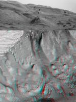
I borrowed Fred's excellent rendition to compare with HiRISE anaglyph of the prime science region around the inverted riverbed. It's a very narrow angle of view. If I marked some features wrong, please let me know.
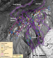
The canyon between "A" and "D" will be epic, if they decide to rove up it. In Matthew Golombek's "Update on Landing Site Characterization" presentation, this canyon's traversability is marked in 4 places as "hasn't been investigated," and marked in 2 places as "small width path, less than 10 meters." Have they determined the traversibility since then, or will it be determined by the rover once it's in the vicinity? I would imagine the long lens in the Mast Cam could get some good shots from the base of the canyon and spot the rough patches. By the way, here's the page from the presentation with the possible routes:
|
||
|
|
|
||
|
Aug 26 2012, 09:31 AM
Post
#48
|
|
 Member Group: Members Posts: 112 Joined: 20-August 12 From: Spain Member No.: 6597 |
I love the outcrop near to point B in the walfy picture. It looks like a plane of ripples
 Also, as Gladstoner says, it seems to be two different distributions of rocks over the soil, and the little ones seem to be more rounded (the bigger ones are now being actively being eroded by the wind as we can see in it shape). |
|
|
|
|
Aug 26 2012, 11:41 AM
Post
#49
|
||
 Senior Member Group: Members Posts: 1465 Joined: 9-February 04 From: Columbus OH USA Member No.: 13 |
QUOTE (stewjack @ Aug 25 2012, 10:18 PM)  This should probably be in the Making anaglyph images, Methods and software thread but my question is did you have any further adjustments in size after cropping out the image from the larger MR area? I did somewhat the same thing*, but the objects in the ML image still appeared much smaller. Just did it by eye in Photoshop--crop the ML, scale it up so that it matches the size of the similar area of the MR, apply level changes to RGB as appropriate, then fine tune the registration by eye using the Move tool and cursor keys until it looks about right. Lots of variables to mess up & it always seems like there are problem areas & as you say it gets a little brain-bending. But haven't tried correcting for distortions--maybe that's key. I suppose the pros use the full CAVHORE camera models to really do it right. Here's the best I can manage with one of the rover track pairs, without any geometric changes:
Looks like you might have stitched a couple of frames together? That's another complication to get right. -------------------- |
|
|
|
|
|
|
Aug 26 2012, 01:04 PM
Post
#50
|
|
|
Junior Member Group: Members Posts: 61 Joined: 5-June 05 From: 46.283N 11.433E :)) Member No.: 401 |
QUOTE (jmknapp @ Aug 26 2012, 01:41 PM) Just did it by eye in Photoshop--crop the ML, scale it up so that it matches the size of the similar area of the MR, apply level changes to RGB as appropriate, then fine tune the registration by eye using the Move tool and cursor keys until it looks about right. I don't find the two debayered frames. I would like to try my anaglyph version. Could you post the two frames? thank you |
|
|
|
|
Aug 26 2012, 04:23 PM
Post
#51
|
|
 Senior Member Group: Members Posts: 3419 Joined: 9-February 04 From: Minneapolis, MN, USA Member No.: 15 |
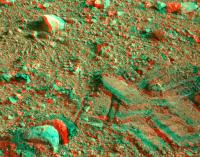
QUOTE (Gladstoner @ Aug 26 2012, 04:19 AM) There seems to be a distinct bimodal size distribution of the pebbles. The smaller ones kind of remind me of blueberries. I believe the geologic term for this is sorting. The surficial material here at Bradbury Landing is well-sorted, meaning there is not a random distribution of particle sizes from fines to boulders. As John Grotzinger pointed out in an early press conference, this suggests the surface is a lag deposit, where a deflationary process has preferentially removed all of the particles of the sizes that are most easily transported by the given process, leaving a lag deposit of the particles that were harder to move and, literally, left behind. As an opposite example, the lunar regolith is considered to be poorly sorted, with impact processes being the only deflationary processes in place, and impacts tend to transport particles of all sizes non-preferentially. One good reason why the surface is reminiscent of the blueberry paving in Meridiani is that, per the best theories I've heard, the Meridiani surficial material is also a lag deposit. The very soft, friable rock that once covered Meridiani has all been deflated by aeolian processes, leaving the much more massive blueberries (which aren't nearly as easily transported by wind) in place as a lag deposit. The deflationary processes do tend to round the edges off the lag particles, resulting in the more rounded appearance. On Earth, a similar process would be the one that paves a creek bed with well-sorted, rounded pebbles. The transport mechanism (water) may be different from the primarily aeolian processes that have held sway on Mars for giga-years, but the principle is basically the same. -the other Doug -------------------- The trouble ain't that there is too many fools, but that the lightning ain't distributed right. -Mark Twain
|
|
|
|
|
Aug 26 2012, 04:46 PM
Post
#52
|
|
|
Senior Member Group: Members Posts: 1465 Joined: 9-February 04 From: Columbus OH USA Member No.: 13 |
QUOTE (malgar @ Aug 26 2012, 08:04 AM) I don't find the two debayered frames. I think we're on our own for debayering (demosaicing) the frames. This page has what I got anyway: http://curiositymsl.com/mcana/ The hills have those weird green patches that people are getting. It'd be interesting to see how JPL does it (Promised Land) -------------------- |
|
|
|
|
Aug 26 2012, 06:15 PM
Post
#53
|
|
 Member Group: Members Posts: 408 Joined: 3-August 05 Member No.: 453 |
QUOTE (jmknapp @ Aug 26 2012, 11:46 AM) I think we're on our own for debayering (demosaicing) the frames. [...] It'd be interesting to see how JPL does it Presumably they work with the original images, not the jpeg (re-)compressed versions we see, and hence they do not have to deal with jpeg compression artifacts interfering with the de-Bayer process. Airbag |
|
|
|
|
Aug 26 2012, 08:48 PM
Post
#54
|
|
|
Member Group: Members Posts: 714 Joined: 3-January 08 Member No.: 3995 |
.
|
|
|
|
|
Aug 26 2012, 08:49 PM
Post
#55
|
|
|
Solar System Cartographer Group: Members Posts: 10151 Joined: 5-April 05 From: Canada Member No.: 227 |
A whole pile of new images just appeared:
http://mars.jpl.nasa.gov/msl/multimedia/raw/?s=19 But not the hazcams or navcams I was hoping for to confirm a drive (we haven't got images from that sol yet, still on sol 19). Mastcam thumbnails point to some great scenes when the full images come down. Phil -------------------- ... because the Solar System ain't gonna map itself.
Also to be found posting similar content on https://mastodon.social/@PhilStooke Maps for download (free PD: https://upload.wikimedia.org/wikipedia/comm...Cartography.pdf NOTE: everything created by me which I post on UMSF is considered to be in the public domain (NOT CC, public domain) |
|
|
|
|
Aug 26 2012, 09:39 PM
Post
#56
|
|
|
Senior Member Group: Members Posts: 3516 Joined: 4-November 05 From: North Wales Member No.: 542 |
ChemCam is already working. A nice article from Science Daily - basalt apparently: http://www.sciencedaily.com/releases/2012/...20824093521.htm
|
|
|
|
|
Aug 26 2012, 09:41 PM
Post
#57
|
||
 The Poet Dude Group: Moderator Posts: 5551 Joined: 15-March 04 From: Kendal, Cumbria, UK Member No.: 60 |
QUOTE (Phil Stooke @ Aug 26 2012, 09:49 PM) Mastcam thumbnails point to some great scenes when the full images come down. Looking forward to those. Got my special glasses ready...

-------------------- |
|
|
|
|
|
|
Aug 26 2012, 10:01 PM
Post
#58
|
|
|
Solar System Cartographer Group: Members Posts: 10151 Joined: 5-April 05 From: Canada Member No.: 227 |
De-bayer that!
Phil -------------------- ... because the Solar System ain't gonna map itself.
Also to be found posting similar content on https://mastodon.social/@PhilStooke Maps for download (free PD: https://upload.wikimedia.org/wikipedia/comm...Cartography.pdf NOTE: everything created by me which I post on UMSF is considered to be in the public domain (NOT CC, public domain) |
|
|
|
|
Aug 26 2012, 10:41 PM
Post
#59
|
|
|
Senior Member Group: Members Posts: 3516 Joined: 4-November 05 From: North Wales Member No.: 542 |
QUOTE (jmknapp @ Aug 26 2012, 05:46 PM) The hills have those weird green patches that people are getting. Go with ugordan. (or Airbag).
|
|
|
|
|
Aug 27 2012, 12:21 AM
Post
#60
|
|
|
Junior Member Group: Members Posts: 37 Joined: 26-January 10 From: Reading, UK Member No.: 5192 |
|
|
|
|
|

|
Lo-Fi Version | Time is now: 25th April 2024 - 07:20 PM |
|
RULES AND GUIDELINES Please read the Forum Rules and Guidelines before posting. IMAGE COPYRIGHT |
OPINIONS AND MODERATION Opinions expressed on UnmannedSpaceflight.com are those of the individual posters and do not necessarily reflect the opinions of UnmannedSpaceflight.com or The Planetary Society. The all-volunteer UnmannedSpaceflight.com moderation team is wholly independent of The Planetary Society. The Planetary Society has no influence over decisions made by the UnmannedSpaceflight.com moderators. |
SUPPORT THE FORUM Unmannedspaceflight.com is funded by the Planetary Society. Please consider supporting our work and many other projects by donating to the Society or becoming a member. |
|