MSL Route Map |

  |
MSL Route Map |
 Apr 6 2016, 07:02 AM Apr 6 2016, 07:02 AM
Post
#781
|
|
 Member  Group: Members Posts: 122 Joined: 3-September 12 From: Almeria, SE Spain Member No.: 6632 |
Hm, this time it shouldn't be too difficult(?)
Some more (50 or so) meters west, then finally turning south again, driving around Helgas Dune.  This would bring us back on this track. Maybe? Thorsten |
 |
 
|
|
Apr 12 2016, 05:29 PM
Post
#782
|
||
|
Solar System Cartographer Group: Members Posts: 10151 Joined: 5-April 05 From: Canada Member No.: 227 |
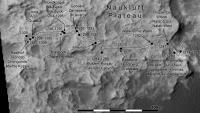
Update to sol 1309 (at last!)
Phil
-------------------- ... because the Solar System ain't gonna map itself.
Also to be found posting similar content on https://mastodon.social/@PhilStooke Maps for download (free PD: https://upload.wikimedia.org/wikipedia/comm...Cartography.pdf NOTE: everything created by me which I post on UMSF is considered to be in the public domain (NOT CC, public domain) |
|
|
|
|
|
|
Apr 13 2016, 04:44 PM
Post
#783
|
||
|
Solar System Cartographer Group: Members Posts: 10151 Joined: 5-April 05 From: Canada Member No.: 227 |
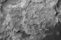
This update to sol 1310 (estimated location) also includes some corrections to recent parts of the path and extends the base to the west. The fractures mentioned in the USGS blog are presumably the raised features forming a rough grid at the northwest corner of today's map. They would be fractures filled with something harder than the surrounding rock, which has resisted erosion.
Phil
-------------------- ... because the Solar System ain't gonna map itself.
Also to be found posting similar content on https://mastodon.social/@PhilStooke Maps for download (free PD: https://upload.wikimedia.org/wikipedia/comm...Cartography.pdf NOTE: everything created by me which I post on UMSF is considered to be in the public domain (NOT CC, public domain) |
|
|
|
|
|
|
Apr 13 2016, 08:41 PM
Post
#784
|
||
 Administrator Group: Admin Posts: 5172 Joined: 4-August 05 From: Pasadena, CA, USA, Earth Member No.: 454 |
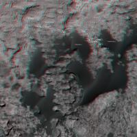
Just for fun, here is a 3D version of the recent route map, based on Phil's mapping. Wider view covering more terrain available here.
Attached thumbnail(s)
-------------------- My website - My Patreon - @elakdawalla on Twitter - Please support unmannedspaceflight.com by donating here.
|
|
|
|
|
|
|
Apr 14 2016, 04:16 AM
Post
#785
|
|
|
Member Group: Members Posts: 122 Joined: 19-June 07 Member No.: 2455 |
QUOTE (elakdawalla @ Apr 13 2016, 01:41 PM)  Just for fun, here is a 3D version of the recent route map, based on Phil's mapping. Wider view covering more terrain available here. The larger map seems to have left and right reversed. The Murray Buttes show up as depressions. If I turn my red/blue glasses upside down it all makes sense. |
|
|
|
|
Apr 14 2016, 02:48 PM
Post
#786
|
|
 Senior Member Group: Members Posts: 4246 Joined: 17-January 05 Member No.: 152 |
Agreed. And the individual L/R links are dead:
http://planetary.s3.amazonaws.com/assets/i...c-4-sols--l.jpg http://planetary.s3.amazonaws.com/assets/i...c-4-sols--r.jpg |
|
|
|
|
Apr 14 2016, 03:11 PM
Post
#787
|
|
|
Administrator Group: Admin Posts: 5172 Joined: 4-August 05 From: Pasadena, CA, USA, Earth Member No.: 454 |
My apologies; I've fixed the wide-view map.
-------------------- My website - My Patreon - @elakdawalla on Twitter - Please support unmannedspaceflight.com by donating here.
|
|
|
|
|
Apr 14 2016, 05:31 PM
Post
#788
|
||
|
Solar System Cartographer Group: Members Posts: 10151 Joined: 5-April 05 From: Canada Member No.: 227 |
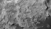
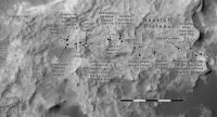
Map updated to sol 1311, but only an estimated position.
Phil
-------------------- ... because the Solar System ain't gonna map itself.
Also to be found posting similar content on https://mastodon.social/@PhilStooke Maps for download (free PD: https://upload.wikimedia.org/wikipedia/comm...Cartography.pdf NOTE: everything created by me which I post on UMSF is considered to be in the public domain (NOT CC, public domain) |
|
|
|
|
|
|
Apr 17 2016, 11:04 PM
Post
#789
|
|
 Member Group: Members Posts: 888 Joined: 15-June 09 From: Lisbon, Portugal Member No.: 4824 |
Excellent 3D map! The twists and turns now make sense to me. Curiosity trully has "outwordly" class drivers!
Update to sol 1310 plus provisional to sol 1311 (I think Curiosity's track can be seen very close to the edge). Fernando  The_Martian_Way_MSL_Curiosity_Sol_1311_2016APR17.kmz ( 402.56K )
Number of downloads: 333
The_Martian_Way_MSL_Curiosity_Sol_1311_2016APR17.kmz ( 402.56K )
Number of downloads: 333 |
|
|
|
|
Apr 18 2016, 09:15 PM
Post
#790
|
||
|
Solar System Cartographer Group: Members Posts: 10151 Joined: 5-April 05 From: Canada Member No.: 227 |
Update to sol 1315 with a correction for the last few sols.
Phil
-------------------- ... because the Solar System ain't gonna map itself.
Also to be found posting similar content on https://mastodon.social/@PhilStooke Maps for download (free PD: https://upload.wikimedia.org/wikipedia/comm...Cartography.pdf NOTE: everything created by me which I post on UMSF is considered to be in the public domain (NOT CC, public domain) |
|
|
|
|
|
|
Apr 19 2016, 05:46 PM
Post
#791
|
||
|
Solar System Cartographer Group: Members Posts: 10151 Joined: 5-April 05 From: Canada Member No.: 227 |
Nearly back to the 1309 position today, apparently for drilling, so presumably the CHIMRA problem has been fixed.
Phil
-------------------- ... because the Solar System ain't gonna map itself.
Also to be found posting similar content on https://mastodon.social/@PhilStooke Maps for download (free PD: https://upload.wikimedia.org/wikipedia/comm...Cartography.pdf NOTE: everything created by me which I post on UMSF is considered to be in the public domain (NOT CC, public domain) |
|
|
|
|
|
|
Apr 25 2016, 06:51 PM
Post
#792
|
|
|
Member Group: Members Posts: 888 Joined: 15-June 09 From: Lisbon, Portugal Member No.: 4824 |
Update to Sol 1317, before she runs ... er, rolls off again
 Fernando
The_Martian_Way_MSL_Curiosity_Sol_1317_2016APR25.kmz ( 402.94K )
Number of downloads: 438 |
|
|
|
|
Apr 27 2016, 06:26 PM
Post
#793
|
|||
|
Solar System Cartographer Group: Members Posts: 10151 Joined: 5-April 05 From: Canada Member No.: 227 |
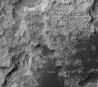
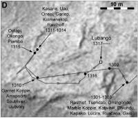
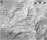
Updates at two scales for our current location.
Phil
-------------------- ... because the Solar System ain't gonna map itself.
Also to be found posting similar content on https://mastodon.social/@PhilStooke Maps for download (free PD: https://upload.wikimedia.org/wikipedia/comm...Cartography.pdf NOTE: everything created by me which I post on UMSF is considered to be in the public domain (NOT CC, public domain) |
||
|
|
|
||
|
May 2 2016, 06:12 PM
Post
#794
|
||
|
Solar System Cartographer Group: Members Posts: 10151 Joined: 5-April 05 From: Canada Member No.: 227 |
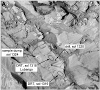
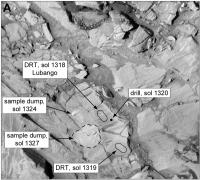
Update to include the 1327 sample dump.
Phil
-------------------- ... because the Solar System ain't gonna map itself.
Also to be found posting similar content on https://mastodon.social/@PhilStooke Maps for download (free PD: https://upload.wikimedia.org/wikipedia/comm...Cartography.pdf NOTE: everything created by me which I post on UMSF is considered to be in the public domain (NOT CC, public domain) |
|
|
|
|
|
|
May 3 2016, 09:13 PM
Post
#795
|
||
|
Solar System Cartographer Group: Members Posts: 10151 Joined: 5-April 05 From: Canada Member No.: 227 |
This shows our new (1329) position, fairly accurately, I think, but I don't know the details of the path to it yet.
Phil
-------------------- ... because the Solar System ain't gonna map itself.
Also to be found posting similar content on https://mastodon.social/@PhilStooke Maps for download (free PD: https://upload.wikimedia.org/wikipedia/comm...Cartography.pdf NOTE: everything created by me which I post on UMSF is considered to be in the public domain (NOT CC, public domain) |
|
|
|
|
|
|

|
Lo-Fi Version | Time is now: 25th April 2024 - 01:08 PM |
|
RULES AND GUIDELINES Please read the Forum Rules and Guidelines before posting. IMAGE COPYRIGHT |
OPINIONS AND MODERATION Opinions expressed on UnmannedSpaceflight.com are those of the individual posters and do not necessarily reflect the opinions of UnmannedSpaceflight.com or The Planetary Society. The all-volunteer UnmannedSpaceflight.com moderation team is wholly independent of The Planetary Society. The Planetary Society has no influence over decisions made by the UnmannedSpaceflight.com moderators. |
SUPPORT THE FORUM Unmannedspaceflight.com is funded by the Planetary Society. Please consider supporting our work and many other projects by donating to the Society or becoming a member. |
|