MSL Route Map |

  |
MSL Route Map |
 Jul 9 2017, 02:58 AM Jul 9 2017, 02:58 AM
Post
#1036
|
||
|
Solar System Cartographer  Group: Members Posts: 10145 Joined: 5-April 05 From: Canada Member No.: 227 |
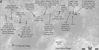
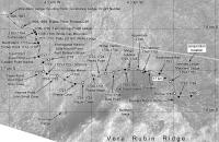
Sol 1478, with a few corrected positions leading up to it.
Phil
-------------------- ... because the Solar System ain't gonna map itself.
Also to be found posting similar content on https://mastodon.social/@PhilStooke NOTE: everything created by me which I post on UMSF is considered to be in the public domain (NOT CC, public domain) |
|
 |
 
|
|
|
Jul 10 2017, 06:02 PM
Post
#1037
|
||
|
Solar System Cartographer Group: Members Posts: 10145 Joined: 5-April 05 From: Canada Member No.: 227 |
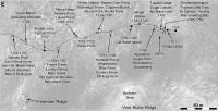
A small move on sol 1751, and I think we will have a fairly clear path to the base of the ridge from here.
Phil
-------------------- ... because the Solar System ain't gonna map itself.
Also to be found posting similar content on https://mastodon.social/@PhilStooke NOTE: everything created by me which I post on UMSF is considered to be in the public domain (NOT CC, public domain) |
|
|
|
|
|
|
Jul 11 2017, 06:51 PM
Post
#1038
|
||
|
Solar System Cartographer Group: Members Posts: 10145 Joined: 5-April 05 From: Canada Member No.: 227 |
Sol 1752 - a 10 m drive to the east.
Phil
-------------------- ... because the Solar System ain't gonna map itself.
Also to be found posting similar content on https://mastodon.social/@PhilStooke NOTE: everything created by me which I post on UMSF is considered to be in the public domain (NOT CC, public domain) |
|
|
|
|
|
|
Jul 15 2017, 12:07 AM
Post
#1039
|
|||
|
Solar System Cartographer Group: Members Posts: 10145 Joined: 5-April 05 From: Canada Member No.: 227 |
I'm updating to sol 1754 today with two maps. A third is in the works with details near the last sand scuff.
Phil
-------------------- ... because the Solar System ain't gonna map itself.
Also to be found posting similar content on https://mastodon.social/@PhilStooke NOTE: everything created by me which I post on UMSF is considered to be in the public domain (NOT CC, public domain) |
||
|
|
|
||
|
Jul 18 2017, 08:52 PM
Post
#1040
|
|
 Member Group: Members Posts: 883 Joined: 15-June 09 From: Lisbon, Portugal Member No.: 4824 |
This update to the "The Martian Way" includes:
- Route update to sol 1759 (last move on sol 1754), with the 17km flag - Three new quadrants that Curiosity will be traversing while exploring the Vera Rubin ridge (names, anyone?) - Several changes to the Mars clock - The clock automatically opens when loading the KMZ, but can be called at any time from the left side bar: -- The displayed time has changed from the MLST (Mean Local Solar Time) at Bradbury Landing to MLST at Curiosity's current position. There is a difference of a few seconds between the two. -- The main painel now also displays Curiosity current location's coordinates (latitude, longitude) -- The text in the information panel - accessible by clicking the twistie at the bottom - has been revised. Fernando  The_Martian_Way_MSL_Curiosity_Sol_1754_2017JUL18.kmz ( 594.82K )
Number of downloads: 315
The_Martian_Way_MSL_Curiosity_Sol_1754_2017JUL18.kmz ( 594.82K )
Number of downloads: 315 |
|
|
|
|
Aug 1 2017, 04:00 PM
Post
#1041
|
||
|
Member Group: Members Posts: 883 Joined: 15-June 09 From: Lisbon, Portugal Member No.: 4824 |
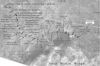
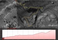
The MSL route map from NASA/JPL press release Mid-2017 Map of NASA's Curiosity Mars Rover Mission encompasses the whole of Curiosity's route since landing plus the path through the light-toned ridge layer (a.k.a. Vera Rubin Ridge), phyllosilicates and sulfate units, and the climb to Marker Bed (names taken from the May 17, 2011, notional route).
The future route path looks quite exciting and is significantly different from the previous (October 3, 2016) notional route, mainly in the "excursions" on the hematite and phyllosilicates terrains, and a totally new climb through previously not visited terrains. The MSL Planned Routes KML document was updated accordingly.
MSL_Planned_Routes_2017JUL11.kmz ( 181.92K )
Number of downloads: 306This new path is about 7.68 Km long and climbs through some 400 m, as illustrated by the image.
Fernando |
|
|
|
|
|
|
Aug 1 2017, 04:11 PM
Post
#1042
|
|
|
Member Group: Members Posts: 923 Joined: 10-November 15 Member No.: 7837 |
Wow... this is new to me!
The original notional route seemed ambitious/dangerous after 'visiting' in VR...it was steep & sandy. OK, now where are my goggles... -------------------- |
|
|
|
|
Aug 5 2017, 03:30 PM
Post
#1043
|
||
|
Solar System Cartographer Group: Members Posts: 10145 Joined: 5-April 05 From: Canada Member No.: 227 |
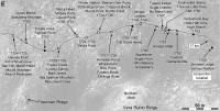
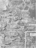
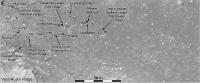
Murray Buttes map as requested. This includes names from the Analyst's Notebook in PDS including M-designations for the buttes. A few numbers are missing (M3, etc.).
Phil
Attached thumbnail(s)
-------------------- ... because the Solar System ain't gonna map itself.
Also to be found posting similar content on https://mastodon.social/@PhilStooke NOTE: everything created by me which I post on UMSF is considered to be in the public domain (NOT CC, public domain) |
|
|
|
|
|
|
Aug 10 2017, 10:12 PM
Post
#1044
|
||
|
Solar System Cartographer Group: Members Posts: 10145 Joined: 5-April 05 From: Canada Member No.: 227 |
Back in the saddle again! Here we are after a drive on sol 1781.
Phil
-------------------- ... because the Solar System ain't gonna map itself.
Also to be found posting similar content on https://mastodon.social/@PhilStooke NOTE: everything created by me which I post on UMSF is considered to be in the public domain (NOT CC, public domain) |
|
|
|
|
|
|
Aug 12 2017, 03:16 AM
Post
#1045
|
||
|
Solar System Cartographer Group: Members Posts: 10145 Joined: 5-April 05 From: Canada Member No.: 227 |
Another shortish drive on sol 1782.
Phil
-------------------- ... because the Solar System ain't gonna map itself.
Also to be found posting similar content on https://mastodon.social/@PhilStooke NOTE: everything created by me which I post on UMSF is considered to be in the public domain (NOT CC, public domain) |
|
|
|
|
|
|
Aug 14 2017, 03:37 PM
Post
#1046
|
||
|
Solar System Cartographer Group: Members Posts: 10145 Joined: 5-April 05 From: Canada Member No.: 227 |
This is the location after the sol 1785 drive.
Phil
-------------------- ... because the Solar System ain't gonna map itself.
Also to be found posting similar content on https://mastodon.social/@PhilStooke NOTE: everything created by me which I post on UMSF is considered to be in the public domain (NOT CC, public domain) |
|
|
|
|
|
|
Aug 15 2017, 06:34 PM
Post
#1047
|
||
|
Solar System Cartographer Group: Members Posts: 10145 Joined: 5-April 05 From: Canada Member No.: 227 |
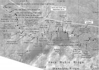
Sol 1786. This drive was supposed to be longer and must have been cut short, probably by excessive tilt or traction issues.
Phil
-------------------- ... because the Solar System ain't gonna map itself.
Also to be found posting similar content on https://mastodon.social/@PhilStooke NOTE: everything created by me which I post on UMSF is considered to be in the public domain (NOT CC, public domain) |
|
|
|
|
|
|
Aug 17 2017, 04:05 PM
Post
#1048
|
||
|
Solar System Cartographer Group: Members Posts: 10145 Joined: 5-April 05 From: Canada Member No.: 227 |
A couple of sols of updates today, maneuvering around obstacles.
Phil
-------------------- ... because the Solar System ain't gonna map itself.
Also to be found posting similar content on https://mastodon.social/@PhilStooke NOTE: everything created by me which I post on UMSF is considered to be in the public domain (NOT CC, public domain) |
|
|
|
|
|
|
Aug 17 2017, 06:25 PM
Post
#1049
|
|
|
Member Group: Members Posts: 883 Joined: 15-June 09 From: Lisbon, Portugal Member No.: 4824 |
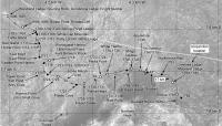
Here is the update to sol 1788. It took a little longer, as explaned in another thread.
The update includes data from PDS Release 15, covering sols 0 to 1689. Fernando
The_Martian_Way_MSL_Curiosity_Sol_1788_2017AUG17.kmz ( 593.24K )
Number of downloads: 247 |
|
|
|
|
Aug 18 2017, 06:07 PM
Post
#1050
|
||
|
Solar System Cartographer Group: Members Posts: 10145 Joined: 5-April 05 From: Canada Member No.: 227 |
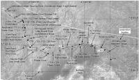
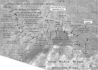
Zooming in a bit as we cross the last bit of Murray Formation and head for the ridge. This includes the sol 1789 drive. (EDIT: replaced map with an updated version)
Phil
-------------------- ... because the Solar System ain't gonna map itself.
Also to be found posting similar content on https://mastodon.social/@PhilStooke NOTE: everything created by me which I post on UMSF is considered to be in the public domain (NOT CC, public domain) |
|
|
|
|
|
|

|
Lo-Fi Version | Time is now: 18th April 2024 - 10:34 AM |
|
RULES AND GUIDELINES Please read the Forum Rules and Guidelines before posting. IMAGE COPYRIGHT |
OPINIONS AND MODERATION Opinions expressed on UnmannedSpaceflight.com are those of the individual posters and do not necessarily reflect the opinions of UnmannedSpaceflight.com or The Planetary Society. The all-volunteer UnmannedSpaceflight.com moderation team is wholly independent of The Planetary Society. The Planetary Society has no influence over decisions made by the UnmannedSpaceflight.com moderators. |
SUPPORT THE FORUM Unmannedspaceflight.com is funded by the Planetary Society. Please consider supporting our work and many other projects by donating to the Society or becoming a member. |
|