MSL Route Map |

  |
MSL Route Map |
 Jun 29 2021, 03:37 AM Jun 29 2021, 03:37 AM
Post
#1561
|
|
|
Solar System Cartographer  Group: Members Posts: 10149 Joined: 5-April 05 From: Canada Member No.: 227 |
That is a very good idea. I am going to have to ask someone else to take care of it, though - I can barely keep up with all the current missions. Anyone who wants to try this can use any of my maps. Nogal provides a continually updated Google Earth .kmz file which may give another solution to the problem.
Phil -------------------- ... because the Solar System ain't gonna map itself.
Also to be found posting similar content on https://mastodon.social/@PhilStooke NOTE: everything created by me which I post on UMSF is considered to be in the public domain (NOT CC, public domain) |
 |
 
|
|
Jun 29 2021, 05:09 AM
Post
#1562
|
|||
 Senior Member Group: Members Posts: 2425 Joined: 30-January 13 From: Penang, Malaysia. Member No.: 6853 |
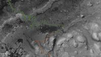
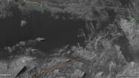
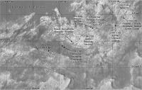
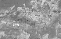
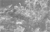
Here are a pair of images saved today from the kmz files shared by 'Nogal' and installed on Google Earth.
The first was zoomed to a 1 km scalebar, the second zoomed to a 200 meter scalebar where the sols are a little less cluttered. The kmz files cover the entire path from landing in 2012, so I have zoomed to a small fraction of what is available. If you have the PC version of Google Earth you can created a wide range of views of the path or parts thereof. In these examples I have turned off most of the features such as place names, target names, milestones, quadrangles etc. Note that the path has different colours, the tan path on the second capture uses PDS data, the white path is from the JSON data (subject to calibration) and the orange path is my edited version of the Mount Sharp Ascent Route (MSAR) version 10 that just shows the remaining path. Nogal's version shows the entire path and many other versions of the MSAR over the years since landing and the latest kmz includes the path up to sol 3158. Updates to the kmz's are posted occasionally by 'Nogal' on this thread, if you have a PC you can install Google Earth in minutes, Nogal's kmz updates are less than 1Mb and take moments to install, that way you can get context as often as you like and I expect there will eventually be updates in the event that there are future changes to the MSAR.
|
||
|
|
|
||
|
Jun 29 2021, 03:51 PM
Post
#1563
|
|
|
Member Group: Members Posts: 910 Joined: 4-September 06 From: Boston Member No.: 1102 |
Excellent Paul and Phil--this was exactly what I hoped to see. Apple doesn't like Google, and so can't install Google Earth/Mars on my MacBook Air to see Nogal's maps.
-------------------- |
|
|
|
|
Jun 29 2021, 04:09 PM
Post
#1564
|
|
|
Founder Group: Chairman Posts: 14431 Joined: 8-February 04 Member No.: 1 |
QUOTE (Floyd @ Jun 29 2021, 08:51 AM)  Apple doesn't like Google, and so can't install Google Earth/Mars on my MacBook Air I have it installed on mine. What's not working? |
|
|
|
|
Jun 30 2021, 12:05 AM
Post
#1565
|
||
 Member Group: Members Posts: 887 Joined: 15-June 09 From: Lisbon, Portugal Member No.: 4824 |
QUOTE (Floyd @ Jun 29 2021, 12:00 AM) Phil, Your maps are excellent, but I wonder if you have considered posting (every few pages of this thread) an 8X zoomed out map with 64X the area for showing the larger context. Hi Floyd, I agree it is an excellent suggestion. I'm sorry I do not have the time right now to properly address it, but it is easy to get it from the kmz file, as Phill and Paul have pointed out (thank you both!). I hope you fix your GE install problem. QUOTE (Phil Stooke @ Jun 28 2021, 09:50 PM) Paul's partial panorama suggests this location for sol 3161, the next step up the staircase. The data for sol 3161 gives me this path, slightly different from Phil's
Lastly, I'll take a look at MSAR 10 and the notional paths collection. Fernando |
|
|
|
|
|
|
Jun 30 2021, 01:51 AM
Post
#1566
|
||
|
Senior Member Group: Members Posts: 2425 Joined: 30-January 13 From: Penang, Malaysia. Member No.: 6853 |
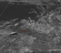
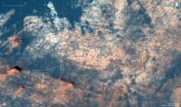
QUOTE (Floyd @ Jun 29 2021, 11:51 PM) Excellent Paul and Phil--this was exactly what I hoped to see. Apple doesn't like Google, and so can't install Google Earth/Mars on my MacBook Air to see Nogal's maps. Like the other comments I hope you can resolve the Google Earth issues you have experienced, as Fernando's Google Earth kmz is spectacularly feature rich. If you can't resolve them, you may want to take a look at the interactive map for this mission that you can now zoom in and out of. It is usually updated after several drives, and the attached screen capture covers the drive on sol 3158.
|
|
|
|
|
|
|
Jun 30 2021, 03:07 AM
Post
#1567
|
|
|
Solar System Cartographer Group: Members Posts: 10149 Joined: 5-April 05 From: Canada Member No.: 227 |
Nogal's location for sol 3161 is correct. I was working with limited data when I suggested that location. It will show up in the next map update.
Phil -------------------- ... because the Solar System ain't gonna map itself.
Also to be found posting similar content on https://mastodon.social/@PhilStooke NOTE: everything created by me which I post on UMSF is considered to be in the public domain (NOT CC, public domain) |
|
|
|
|
Jun 30 2021, 06:30 PM
Post
#1568
|
|
|
Member Group: Members Posts: 887 Joined: 15-June 09 From: Lisbon, Portugal Member No.: 4824 |
It is always good to see your maps, Phil. You put in some really hard work and they've helped me many times.
Though I enjoy knowing the rover's whereabouts in as near-real-time as possible, the amount of time I am able to dedicate to this project is not much so, as I've said several times, my updates can lag behind, despite trying to make them weekly. Meanwhile you've already appeased our thirst. The data I use for the route comes almost exclusively from JPL (not geojson data, which has few data points), so I can not take any credit in having the location right. Those data sometimes takes days to be updated, especially at weekends, but I am not complaining. This is perfectly fine with me and it is great to be able to have it available. Thank you and please keep up your great work. Fernando |
|
|
|
|
Jun 30 2021, 09:03 PM
Post
#1569
|
||
|
Solar System Cartographer Group: Members Posts: 10149 Joined: 5-April 05 From: Canada Member No.: 227 |
Thanks, nogal! Here is the sol 3163 map with the corrected path. This looks like being a drill location so we may be here for a few weeks.
Phil
-------------------- ... because the Solar System ain't gonna map itself.
Also to be found posting similar content on https://mastodon.social/@PhilStooke NOTE: everything created by me which I post on UMSF is considered to be in the public domain (NOT CC, public domain) |
|
|
|
|
|
|
Jun 30 2021, 09:05 PM
Post
#1570
|
|
|
Member Group: Members Posts: 910 Joined: 4-September 06 From: Boston Member No.: 1102 |
QUOTE (djellison @ Jun 29 2021, 11:09 AM) I have it installed on mine. What's not working? If I recall correctly, I dropped one of Nogal's map files on my MacBook and got a message that I had no program to open it and none was available from the Apple store---both were correct. However, I incorrectly concluded there was no Google Earth Pro for Mac. Seeing your comment, I went to Google and of course Google Earth Pro was THERE and I downloaded it with no problem. Thanks for prodding me to investigate further. -------------------- |
|
|
|
|
Jul 3 2021, 05:41 PM
Post
#1571
|
|
|
Member Group: Members Posts: 887 Joined: 15-June 09 From: Lisbon, Portugal Member No.: 4824 |
Here is the update to sol 3165. Another small bump, since the sol 3163 location was not perfect.
This time I'm using geojson data for sols 3163-3165. It wil be replaced with more precise data when available. Fernando  The_Martian_Way_MSL_Curiosity_Sol_3165_2021JUL03.kmz ( 852.92K )
Number of downloads: 178
The_Martian_Way_MSL_Curiosity_Sol_3165_2021JUL03.kmz ( 852.92K )
Number of downloads: 178______________________________________________ Gale crater/MSL route base map (HiRISE mosaic): - see post #1078 for description and installation instructions - direct link to the file (1.6 GB) https://drive.google.com/file/d/0Bww-fQ2HUe...iew?usp=sharing KML Collection of planned/notional routes: see post #1392 |
|
|
|
|
Jul 16 2021, 09:03 PM
Post
#1572
|
||
 Member Group: Members Posts: 349 Joined: 20-June 07 From: Slovenia Member No.: 2461 |
Sol 3179 update. No drive, but a lot of targets and a new drill site. |
|
|
|
|
|
|
Jul 21 2021, 07:26 PM
Post
#1573
|
||
|
Solar System Cartographer Group: Members Posts: 10149 Joined: 5-April 05 From: Canada Member No.: 227 |
Update to sol 3183 - we moved again after the Pontours drill. I am working on a more detailed map of this area.
Phil
-------------------- ... because the Solar System ain't gonna map itself.
Also to be found posting similar content on https://mastodon.social/@PhilStooke NOTE: everything created by me which I post on UMSF is considered to be in the public domain (NOT CC, public domain) |
|
|
|
|
|
|
Jul 25 2021, 11:59 PM
Post
#1574
|
||
|
Solar System Cartographer Group: Members Posts: 10149 Joined: 5-April 05 From: Canada Member No.: 227 |
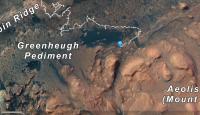
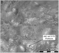
This is a close-up (larger scale) map of the drill area. The major features of the background image are positioned to fit a HiRISE base but there are large residual distortions between them.
Phil
-------------------- ... because the Solar System ain't gonna map itself.
Also to be found posting similar content on https://mastodon.social/@PhilStooke NOTE: everything created by me which I post on UMSF is considered to be in the public domain (NOT CC, public domain) |
|
|
|
|
|
|
Jul 26 2021, 02:51 AM
Post
#1575
|
||
|
Solar System Cartographer Group: Members Posts: 10149 Joined: 5-April 05 From: Canada Member No.: 227 |
And a map for sol 3185.
Phil
-------------------- ... because the Solar System ain't gonna map itself.
Also to be found posting similar content on https://mastodon.social/@PhilStooke NOTE: everything created by me which I post on UMSF is considered to be in the public domain (NOT CC, public domain) |
|
|
|
|
|
|

|
Lo-Fi Version | Time is now: 23rd April 2024 - 02:34 PM |
|
RULES AND GUIDELINES Please read the Forum Rules and Guidelines before posting. IMAGE COPYRIGHT |
OPINIONS AND MODERATION Opinions expressed on UnmannedSpaceflight.com are those of the individual posters and do not necessarily reflect the opinions of UnmannedSpaceflight.com or The Planetary Society. The all-volunteer UnmannedSpaceflight.com moderation team is wholly independent of The Planetary Society. The Planetary Society has no influence over decisions made by the UnmannedSpaceflight.com moderators. |
SUPPORT THE FORUM Unmannedspaceflight.com is funded by the Planetary Society. Please consider supporting our work and many other projects by donating to the Society or becoming a member. |
|