MSL Route Map |

  |
MSL Route Map |
 Aug 16 2021, 02:29 PM Aug 16 2021, 02:29 PM
Post
#1591
|
||
 Member  Group: Members Posts: 883 Joined: 15-June 09 From: Lisbon, Portugal Member No.: 4824 |
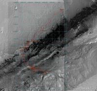
This [long] update to sol 3206 includes data from PDS Release 27 and introduces a new version (version 4!) of the KML file. The file shows a new features' arrangement and structure in the Places panel (GE's left side panel). I felt the old structure was becoming very large and more difficult to handle. Over many months I completely rebuilt and expanded the software I use to manage the data and generate the kml file, making it more easy and faster to update the data and generate the kml code.
Data from PDS Release 27 includes: - Route localization data for sols 0-3113 (the full path has been reviewed and updated) - Analyst's Notebook data for sols 1-3068 In the new version, with the exception of the Mars clock, all the old and new features have been placed under two groups according to them being route related or science related. Route features:
I'd appreciate to know your opinion and please let me know if you find any errors or have any suggestions such as, for instance, including the Planned/Notional Routes set (eliminating that separate file) in the routes group. Thank you and enjoy as Curiosity starts a new chapter of its adventures! Fernando  The_Martian_Way_MSL_Curiosity_Sol_3206_2021AUG16.kmz ( 1.07MB )
Number of downloads: 219
The_Martian_Way_MSL_Curiosity_Sol_3206_2021AUG16.kmz ( 1.07MB )
Number of downloads: 219______________________________________________ Gale crater/MSL route base map (HiRISE mosaic): - see post #1078 for description and installation instructions - direct link to the file (1.6 GB) https://drive.google.com/file/d/0Bww-fQ2HUe...iew?usp=sharing KML Collection of planned/notional routes: see post #1392 |
|
 |
 
|
|
|
Aug 17 2021, 07:16 PM
Post
#1592
|
||
|
Member Group: Members Posts: 883 Joined: 15-June 09 From: Lisbon, Portugal Member No.: 4824 |
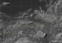
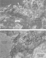
Since Phil is away, here is Curiosity's progress on sol 3210.
Fernando
|
|
|
|
|
|
|
Aug 17 2021, 08:15 PM
Post
#1593
|
|
|
Member Group: Members Posts: 883 Joined: 15-June 09 From: Lisbon, Portugal Member No.: 4824 |
I had promised to take a look at MSAR 10. It is very similar to MSAR 9 minus the loops around the big hill.
It should be easy to add it to the Notional/Planned Routes collection, but would it be better to keep that file separate or merge it with "The Martian Way"? Either way is fine with me. Fernando |
|
|
|
|
Aug 18 2021, 03:27 AM
Post
#1594
|
|
 Senior Member Group: Members Posts: 2425 Joined: 30-January 13 From: Penang, Malaysia. Member No.: 6853 |
QUOTE (nogal @ Aug 18 2021, 04:15 AM)  I had promised to take a look at MSAR 10. It is very similar to MSAR 9 minus the loops around the big hill. It should be easy to add it to the Notional/Planned Routes collection, but would it be better to keep that file separate or merge it with "The Martian Way"? Either way is fine with me. Fernando It may be better to merge MSAR 10 inside 'The Martian Way' during a future update. That way one could share the file with a new user without the complication of having multiple files to install. The older (superseded) paths could be archived in an additional file? Just a thought...  BTW really enjoying the new format and its features |
|
|
|
|
Aug 18 2021, 05:20 AM
Post
#1595
|
|
|
Solar System Cartographer Group: Members Posts: 10146 Joined: 5-April 05 From: Canada Member No.: 227 |
"Since Phil is away, here is Curiosity's progress on sol 3210. "
Thanks, nogal, I will be catching up in a few days. Phil -------------------- ... because the Solar System ain't gonna map itself.
Also to be found posting similar content on https://mastodon.social/@PhilStooke NOTE: everything created by me which I post on UMSF is considered to be in the public domain (NOT CC, public domain) |
|
|
|
|
Aug 19 2021, 01:16 AM
Post
#1596
|
|
|
Member Group: Members Posts: 883 Joined: 15-June 09 From: Lisbon, Portugal Member No.: 4824 |
QUOTE (PaulH51 @ Aug 18 2021, 04:27 AM) It may be better to merge MSAR 10 inside 'The Martian Way' during a future update. Thank you Paul. I think that the Notional/Planned Routes file will add under 200k, so it is feasible to add it all. But I'll add MSAR 10 first and see how difficult that is. Fernando |
|
|
|
|
Aug 19 2021, 05:00 PM
Post
#1597
|
||
|
Member Group: Members Posts: 883 Joined: 15-June 09 From: Lisbon, Portugal Member No.: 4824 |
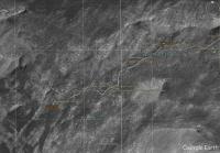
Another move of aproximately 17m to the WSW on sol 3211.
Fernando
|
|
|
|
|
|
|
Aug 20 2021, 07:07 PM
Post
#1598
|
||
|
Member Group: Members Posts: 883 Joined: 15-June 09 From: Lisbon, Portugal Member No.: 4824 |
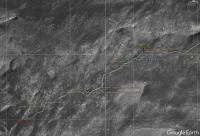
Curisity roved another 30m on sol 3212.
Fernando
|
|
|
|
|
|
|
Aug 22 2021, 07:04 AM
Post
#1599
|
||
|
Solar System Cartographer Group: Members Posts: 10146 Joined: 5-April 05 From: Canada Member No.: 227 |
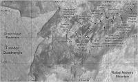
Finally catching up ... here is my map up to sol 3212. It's getting cluttered with names so I will make a more detailed map of part of it. Thanks Nogal for filling in for me.
Phil
-------------------- ... because the Solar System ain't gonna map itself.
Also to be found posting similar content on https://mastodon.social/@PhilStooke NOTE: everything created by me which I post on UMSF is considered to be in the public domain (NOT CC, public domain) |
|
|
|
|
|
|
Aug 22 2021, 01:53 PM
Post
#1600
|
|
|
Member Group: Members Posts: 883 Joined: 15-June 09 From: Lisbon, Portugal Member No.: 4824 |
Glad you're back!
Sometimes it is hard to find which sol the targets' names belong to: I had misplaced Blis-et-Born. I did not include Gogar on sol 3209 because it refers to a knoll ("Gogar") crosscut by veins in our drive direction which location I am not sure of. I combed the images but could not positively identify it. Any help much appreciated! Fernando |
|
|
|
|
Aug 22 2021, 03:23 PM
Post
#1601
|
|
|
Solar System Cartographer Group: Members Posts: 10146 Joined: 5-April 05 From: Canada Member No.: 227 |
I add names I cannot locate at this stage, but use the identified target in the PDS Analyst's Notebook to reposition it later. Sometimes I mis-locate a name but the Analyst's Notebook is a check on that as well. Often a target is examined just before a drive so it appears as a sol n target but at the sol n-1 location.
Phil -------------------- ... because the Solar System ain't gonna map itself.
Also to be found posting similar content on https://mastodon.social/@PhilStooke NOTE: everything created by me which I post on UMSF is considered to be in the public domain (NOT CC, public domain) |
|
|
|
|
Aug 28 2021, 09:37 PM
Post
#1602
|
||
|
Solar System Cartographer Group: Members Posts: 10146 Joined: 5-April 05 From: Canada Member No.: 227 |
Update to sol 3219 - I have been so busy that I fell behind. I am working on a larger scale map to spread out the many names, after which I can simplify this one a bit.
Phil
Attached thumbnail(s)
-------------------- ... because the Solar System ain't gonna map itself.
Also to be found posting similar content on https://mastodon.social/@PhilStooke NOTE: everything created by me which I post on UMSF is considered to be in the public domain (NOT CC, public domain) |
|
|
|
|
|
|
Sep 13 2021, 03:36 PM
Post
#1603
|
|
|
Member Group: Members Posts: 883 Joined: 15-June 09 From: Lisbon, Portugal Member No.: 4824 |
Update to sol 3235 (Curiosity is still at the 3222 location) including the new drill hole, Maria Gordon.
Fernando
The_Martian_Way_MSL_Curiosity_Sol_3235_2021SEP13.kmz ( 1.07MB )
Number of downloads: 171______________________________________________ Gale crater/MSL route base map (HiRISE mosaic): - see post #1078 for description and installation instructions - direct link to the file (1.6 GB) https://drive.google.com/file/d/0Bww-fQ2HUe...iew?usp=sharing KML Collection of planned/notional routes: see post #1392 |
|
|
|
|
Sep 23 2021, 02:47 PM
Post
#1604
|
|
|
Member Group: Members Posts: 883 Joined: 15-June 09 From: Lisbon, Portugal Member No.: 4824 |
Though Curiosity remains at the sol 3222 location, a few names have been added, including Siccar Point, and the Maria Gordon Notch location was corrected. The drill hole #33's image was replaced by a more detailed one.
I have completed the merging of the Planned/Notional Routes kmz file with The Martian Way kmz file (the kmz did grow a bit). Please find all the routes in the Route-> Path and Sols -> Notional Routes folder. The routes are listed (from top to bottom) in reverse chronological order, I presume the most recent will be the most consulted one. To highlight this change, MSAR v10 is visible at load time and all others are hidden (but, as usual, can be made visible from GE's Places side panel.) In the future, however, all the planned/notional routes will be hidden by default. I have created a new folder in my Google Drive (see link below.) Named "The_Martian_Way", it contains, at the present, the very large HiRISE mosaic and the latest release of the KMZ file. Anyone with the link can access it, there is no need to sign in to Google or even have a Google account. I will continue to post here all updates to the KMZ file, and Google Drive will have the latest update only. Fernando
The_Martian_Way_MSL_Curiosity_Sol_3245_2021SEP23.kmz ( 1.26MB )
Number of downloads: 158______________________________________________ The Martian Way files can also be downloaded from: https://drive.google.com/drive/folders/1OJH...BbQ?usp=sharing See post #1078 for a description and installation instructions of the Gale crater/MSL route base map (HiRISE mosaic) See post #1392 for a description of the Collection of Planned/Notional routes |
|
|
|
|
Sep 26 2021, 01:13 PM
Post
#1605
|
|
|
Member Group: Members Posts: 883 Joined: 15-June 09 From: Lisbon, Portugal Member No.: 4824 |
It is now a little over seven years since I started plotting Curiosity's route in Google Earth.
From a simple path, the project grew to include a multitude of features. Although I have provided a short description every time I introduced one, they are scattered in this thread. Occasional visitors and new members following the thread may, thus, have difficulty getting the whole picture. I have received requests to create more solid documentation, so here is a user's guide to The Martian Way project. My thanks to all who have generously provided their help, encouragement, and feedback during this already long period. I've also placed the Guide in the Google Drive folder, see the previous post and find the link below. Any future updates will be posted to both locations. Fernando  TheMartianWay_UserGuide_V1.0.pdf ( 2.14MB )
Number of downloads: 225
TheMartianWay_UserGuide_V1.0.pdf ( 2.14MB )
Number of downloads: 225_____________________________________________________________________ The Martian Way files can also be downloaded from: https://drive.google.com/drive/folders/1OJH...BbQ?usp=sharing Included are "The Martian Way" KMZ file, User's Guide, and MSL Orbital map of Gale crater. |
|
|
|
|

|
Lo-Fi Version | Time is now: 19th April 2024 - 02:43 AM |
|
RULES AND GUIDELINES Please read the Forum Rules and Guidelines before posting. IMAGE COPYRIGHT |
OPINIONS AND MODERATION Opinions expressed on UnmannedSpaceflight.com are those of the individual posters and do not necessarily reflect the opinions of UnmannedSpaceflight.com or The Planetary Society. The all-volunteer UnmannedSpaceflight.com moderation team is wholly independent of The Planetary Society. The Planetary Society has no influence over decisions made by the UnmannedSpaceflight.com moderators. |
SUPPORT THE FORUM Unmannedspaceflight.com is funded by the Planetary Society. Please consider supporting our work and many other projects by donating to the Society or becoming a member. |
|