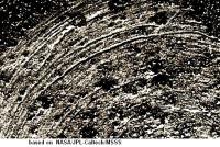
First drill stop: John Klein in Yellowknife Bay, Site 6, Sol 166-271, January 23-May 12, 2013 |

  |
First drill stop: John Klein in Yellowknife Bay, Site 6, Sol 166-271, January 23-May 12, 2013 |
 Jan 28 2013, 12:08 PM Jan 28 2013, 12:08 PM
Post
#31
|
|
 Senior Member  Group: Members Posts: 1619 Joined: 12-February 06 From: Bergerac - FR Member No.: 678 |
168 & 169 updated with the latest frames :
-------------------- |
 |
 
|
|
Jan 28 2013, 12:55 PM
Post
#32
|
|
|
Senior Member Group: Members Posts: 2346 Joined: 7-December 12 Member No.: 6780 |
|
|
|
|
|
Jan 28 2013, 01:06 PM
Post
#33
|
|
 Senior Member Group: Members Posts: 1465 Joined: 9-February 04 From: Columbus OH USA Member No.: 13 |
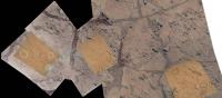
MAHLI mosaic, sol 168--click for zoom.it version:

-------------------- |
|
|
|
|
Jan 28 2013, 04:26 PM
Post
#34
|
|
|
Solar System Cartographer Group: Members Posts: 10151 Joined: 5-April 05 From: Canada Member No.: 227 |
Looking at the brushed area in 169 and 170 images, it looks as if the target was brushed twice on sol 169, with the DRT offset a bit between them, and then a third brushing across the middle of them on the same sol. Then on 170 the left end of the brushed area was brushed again.
Phil (Thanks jmknapp for that nice mosaic and your new route plot in the map thread) -------------------- ... because the Solar System ain't gonna map itself.
Also to be found posting similar content on https://mastodon.social/@PhilStooke Maps for download (free PD: https://upload.wikimedia.org/wikipedia/comm...Cartography.pdf NOTE: everything created by me which I post on UMSF is considered to be in the public domain (NOT CC, public domain) |
|
|
|
|
Jan 29 2013, 03:01 AM
Post
#35
|
||||
 Member Group: Members Posts: 408 Joined: 3-August 05 Member No.: 453 |
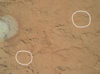
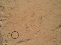
There are two sets of very similar (other than time of day) MAHLI images from sols 170 and 171, and based on what I read here I assumed they were the before and after images of where the drill's "stand off" (pre-load) posts were in contact with the surface. And sure enough, what I think must be the characteristic tell-tale indentations of the tiny spikes on the posts are visible in for instance these areas:
Close ups before and after (animations):
I will leave it as an exercise for the reader to find the equivalent sets in the other three image pairs  Airbag |
|||
|
|
|
|||
|
Jan 29 2013, 03:44 AM
Post
#36
|
|
 Member Group: Members Posts: 399 Joined: 28-August 07 From: San Francisco Member No.: 3511 |
Anyone know which direction (wrt MAHLI images) the DRT brushes rotate? Have some concretions become dislodged since brushing?...
-------------------- 'She drove until the wheels fell off...'
|
|
|
|
|
Jan 29 2013, 04:28 AM
Post
#37
|
|
 Administrator Group: Admin Posts: 5172 Joined: 4-August 05 From: Pasadena, CA, USA, Earth Member No.: 454 |
As of sol 166 they've incremented the site counter to 6, and it now seems that they do that when they're getting ready to stay a while and do some serious sampling activity. (They incremented to 4 when they pulled up to the CAP 2 spot on sol 29, and to 5 when they arrived at Rocknest for the first soil sample on sol 57.) So it seems to me to be a good spot to break off the "traveling to Glenelg" thread and start a new one. Happy drilling, Curiosity!
Here's a link to the current position in the Route Map thread. -------------------- My website - My Patreon - @elakdawalla on Twitter - Please support unmannedspaceflight.com by donating here.
|
|
|
|
|
Jan 29 2013, 02:03 PM
Post
#38
|
||
|
Solar System Cartographer Group: Members Posts: 10151 Joined: 5-April 05 From: Canada Member No.: 227 |
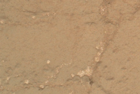
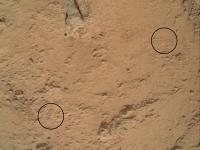
Here's another of the drill press points:
Phil -------------------- ... because the Solar System ain't gonna map itself.
Also to be found posting similar content on https://mastodon.social/@PhilStooke Maps for download (free PD: https://upload.wikimedia.org/wikipedia/comm...Cartography.pdf NOTE: everything created by me which I post on UMSF is considered to be in the public domain (NOT CC, public domain) |
|
|
|
|
|
|
Jan 29 2013, 02:08 PM
Post
#39
|
||
|
Solar System Cartographer Group: Members Posts: 10151 Joined: 5-April 05 From: Canada Member No.: 227 |
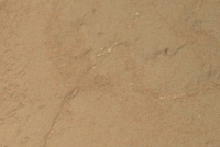
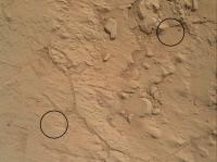
and another set:
Phil -------------------- ... because the Solar System ain't gonna map itself.
Also to be found posting similar content on https://mastodon.social/@PhilStooke Maps for download (free PD: https://upload.wikimedia.org/wikipedia/comm...Cartography.pdf NOTE: everything created by me which I post on UMSF is considered to be in the public domain (NOT CC, public domain) |
|
|
|
|
|
|
Jan 29 2013, 02:19 PM
Post
#40
|
||
|
Solar System Cartographer Group: Members Posts: 10151 Joined: 5-April 05 From: Canada Member No.: 227 |
and the last set:
The second point in the post two above is still eluding me... Phil -------------------- ... because the Solar System ain't gonna map itself.
Also to be found posting similar content on https://mastodon.social/@PhilStooke Maps for download (free PD: https://upload.wikimedia.org/wikipedia/comm...Cartography.pdf NOTE: everything created by me which I post on UMSF is considered to be in the public domain (NOT CC, public domain) |
|
|
|
|
|
|
Jan 29 2013, 03:01 PM
Post
#41
|
|
 Member Group: Members Posts: 691 Joined: 21-December 07 From: Clatskanie, Oregon Member No.: 3988 |
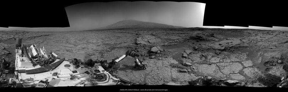
A sneek peak at the Beautiful 360 degree Mastcam panorama that Curiosity took on Sol-170.
|
|
|
|
|
Jan 29 2013, 05:26 PM
Post
#42
|
||
|
Solar System Cartographer Group: Members Posts: 10151 Joined: 5-April 05 From: Canada Member No.: 227 |
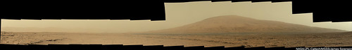
This is a mash-up of several images - jmknapp's MAHLI mosaic, James Sorenson's recent mosaic, and some of the recent sites noted above. There's one more image with drill press marks that I have not yet found on here. (it's off to the lower left from here)
Phil
-------------------- ... because the Solar System ain't gonna map itself.
Also to be found posting similar content on https://mastodon.social/@PhilStooke Maps for download (free PD: https://upload.wikimedia.org/wikipedia/comm...Cartography.pdf NOTE: everything created by me which I post on UMSF is considered to be in the public domain (NOT CC, public domain) |
|
|
|
|
|
|
Jan 29 2013, 06:38 PM
Post
#43
|
||
|
Solar System Cartographer Group: Members Posts: 10151 Joined: 5-April 05 From: Canada Member No.: 227 |
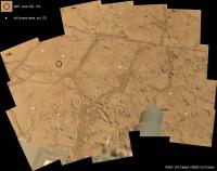
... and now all the locations (except the one I can't see yet) plotted on Edtruthan's mosaic.
Phil
-------------------- ... because the Solar System ain't gonna map itself.
Also to be found posting similar content on https://mastodon.social/@PhilStooke Maps for download (free PD: https://upload.wikimedia.org/wikipedia/comm...Cartography.pdf NOTE: everything created by me which I post on UMSF is considered to be in the public domain (NOT CC, public domain) |
|
|
|
|
|
|
Jan 29 2013, 07:02 PM
Post
#44
|
|
 Senior Member Group: Members Posts: 2173 Joined: 28-December 04 From: Florida, USA Member No.: 132 |
QUOTE (elakdawalla @ Jan 28 2013, 11:28 PM)  As of sol 166 they've incremented the site counter to 6... Normally I don' t bother with the tech talk that goes over my head, but this one is bothering me. Could you explain the purpose of the site counter and what incrementing it means?
|
|
|
|
|
Jan 29 2013, 07:03 PM
Post
#45
|
|
|
Member Group: Members Posts: 408 Joined: 3-August 05 Member No.: 453 |
QUOTE (Phil Stooke @ Jan 29 2013, 01:38 PM) ... and now all the locations (except the one I can't see yet) plotted on Edtruthan's mosaic. Phil You get an "A-" Phil; it would have been an full "A" if you had found the last one too BTW, I just came across a wonderfully detailed document about the drill and its testing for all you fellow gearheads out there. Airbag |
|
|
|
|

|
Lo-Fi Version | Time is now: 25th April 2024 - 09:45 AM |
|
RULES AND GUIDELINES Please read the Forum Rules and Guidelines before posting. IMAGE COPYRIGHT |
OPINIONS AND MODERATION Opinions expressed on UnmannedSpaceflight.com are those of the individual posters and do not necessarily reflect the opinions of UnmannedSpaceflight.com or The Planetary Society. The all-volunteer UnmannedSpaceflight.com moderation team is wholly independent of The Planetary Society. The Planetary Society has no influence over decisions made by the UnmannedSpaceflight.com moderators. |
SUPPORT THE FORUM Unmannedspaceflight.com is funded by the Planetary Society. Please consider supporting our work and many other projects by donating to the Society or becoming a member. |
|