

Heading south from Cape York, Opportunity's post-conjunction adventures / Sol 3291 - 3387 |

  |
Heading south from Cape York, Opportunity's post-conjunction adventures / Sol 3291 - 3387 |
 Jun 12 2013, 03:22 PM Jun 12 2013, 03:22 PM
Post
#166
|
|
|
Solar System Cartographer  Group: Members Posts: 10196 Joined: 5-April 05 From: Canada Member No.: 227 |
"it does seem to turn a gusty thing into a DD-like thing."
Maybe you're right - it should be thought of as a little puff of dust raised by the wind rather than an actual dust devil, and the stretched image would be misleading. After all, that technique would make ground cover look like a forest (or the Viking 2 site look like a Christmas tree farm). As for documentation, I never read it so I'm not going to start writing it! Phil -------------------- ... because the Solar System ain't gonna map itself.
Also to be found posting similar content on https://mastodon.social/@PhilStooke Maps for download (free PD: https://upload.wikimedia.org/wikipedia/comm...Cartography.pdf NOTE: everything created by me which I post on UMSF is considered to be in the public domain (NOT CC, public domain) |
 |
 
|
|
Jun 12 2013, 03:23 PM
Post
#167
|
|
 Senior Member Group: Moderator Posts: 3431 Joined: 11-August 04 From: USA Member No.: 98 |
QUOTE (Bill Harris @ Jun 12 2013, 07:41 AM)  this can wreak havoc with the Auto-exposure and make processing the image challenging. I think this is only a problem with the stretched JPGs from the web; I don't think it generally affects the PDS data, although I could be wrong. |
|
|
|
|
Jun 12 2013, 03:52 PM
Post
#168
|
||
|
Senior Member Group: Members Posts: 2998 Joined: 30-October 04 Member No.: 105 |
May well be, but I'm thinking it'll affect the the total exposure of the frame. We'll see what it looks like in 6 mos when it hits PDS...
QUOTE Maybe you're right - it should be thought of as a little puff of dust raised by the wind rather than an actual dust devil, and the stretched image would be misleading May be. It did strange things to the DDs over at Gusev...--Bill
Attached thumbnail(s)
-------------------- |
|
|
|
|
|
|
Jun 12 2013, 04:08 PM
Post
#169
|
|
|
Solar System Cartographer Group: Members Posts: 10196 Joined: 5-April 05 From: Canada Member No.: 227 |
Yikes, it's like the fountains at Versailles!
Phil -------------------- ... because the Solar System ain't gonna map itself.
Also to be found posting similar content on https://mastodon.social/@PhilStooke Maps for download (free PD: https://upload.wikimedia.org/wikipedia/comm...Cartography.pdf NOTE: everything created by me which I post on UMSF is considered to be in the public domain (NOT CC, public domain) |
|
|
|
|
Jun 12 2013, 04:45 PM
Post
#170
|
|
 Senior Member Group: Admin Posts: 4763 Joined: 15-March 05 From: Glendale, AZ Member No.: 197 |
The @n0m@lists would have a field day with those.
-------------------- If Occam had heard my theory, things would be very different now.
|
|
|
|
|
Jun 12 2013, 08:21 PM
Post
#171
|
|
|
Senior Member Group: Members Posts: 2998 Joined: 30-October 04 Member No.: 105 |
QUOTE Yikes, it's like the fountains at Versailles! Yes indeedie. It reminds me of a booming, honking something-or-other from Pepperland in the movie Yellow Submarine. Or somesuch silliness, like Monty Python.  I've gone through my archives and it seems that in 2005 when we first started noticing Dust Devils at the the Spirit/Gusev site we did a lot of vertical exaggerations and animated GIF sequences. I note that many times the DDs are present as the broad, diffuse gusty areas, especially when developing and as they fall apart. And the vertical exaggeration and contrast enhancement technique would help to bring out thew DDs on these distant images of the Endeavour Central Mound (which is about as good a situation for DD hunting as the Spirit On A Hill scenario that we used before). It is not hard to do a Crop/Resize/Contrast-Tweak on incoming images of the Central Mound. --Bill -------------------- |
|
|
|
|
Jun 13 2013, 12:32 AM
Post
#172
|
|
|
Senior Member Group: Members Posts: 1045 Joined: 17-February 09 Member No.: 4605 |
Dust devils? Cool, but possiby a touch passé. The probable gypsum veins in this remnant of the rim are more interesting. The rim has overrun by plains material, which means that there was massive erosion of the NW edge of Endeavour prior to that event. But was the gypsum formed within the rim which implies that these veins predate the plains material deposition and associated liquid water. Or are they the product of the same water event that is evidenced by Opportunity's observations of the plains material? I find it a touch disappointing that there seems to have been little correlation (at least in published articles) between Opportunity's limited area investigations and Endeavour crater as a whole. The hematite signature of the internal mound raises a lot of questions about how there was sufficient groundwater to form berries (assuming they are the hematite source in that area) unless the crater were filled with water.
|
|
|
|
|
Jun 13 2013, 05:51 AM
Post
#173
|
|
 Member Group: Members Posts: 404 Joined: 5-January 10 Member No.: 5161 |
|
|
|
|
|
Jun 13 2013, 10:26 AM
Post
#174
|
|
 Senior Member Group: Members Posts: 1619 Joined: 12-February 06 From: Bergerac - FR Member No.: 678 |
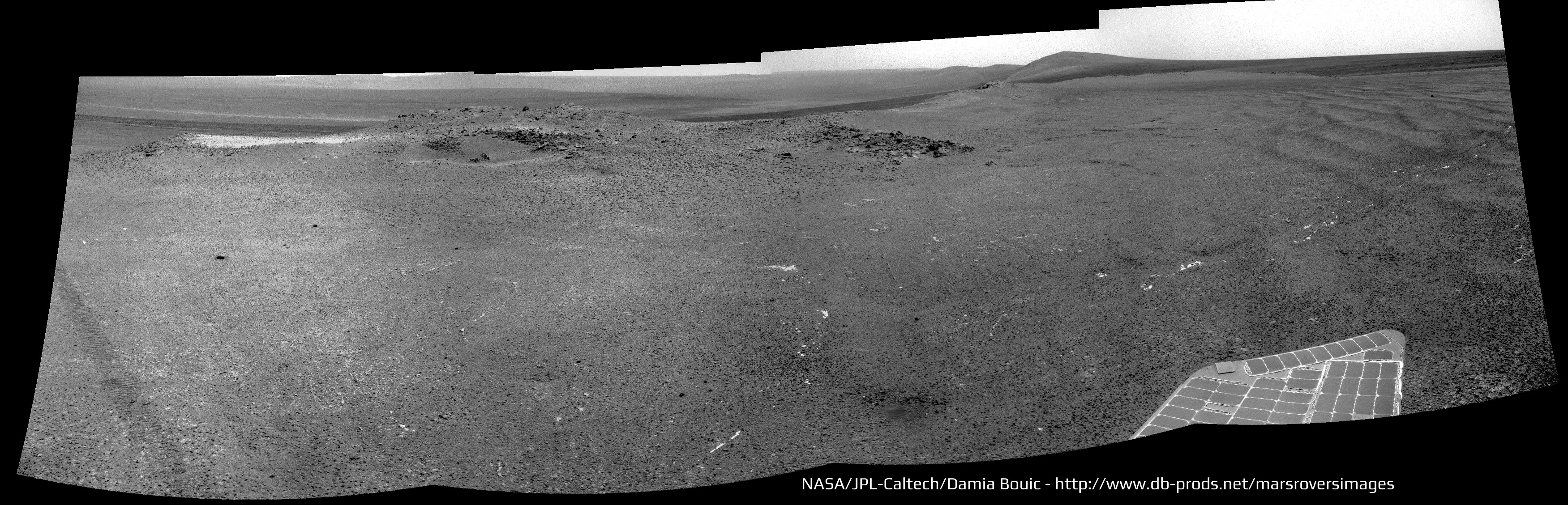
Yes Walfy. So much imagery this sol
 A color portion of a bigger panorama, I think : 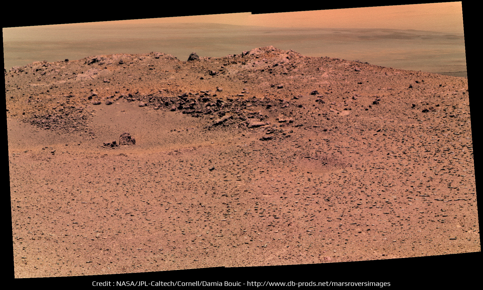 The bigger panorama, in greyscale for now : 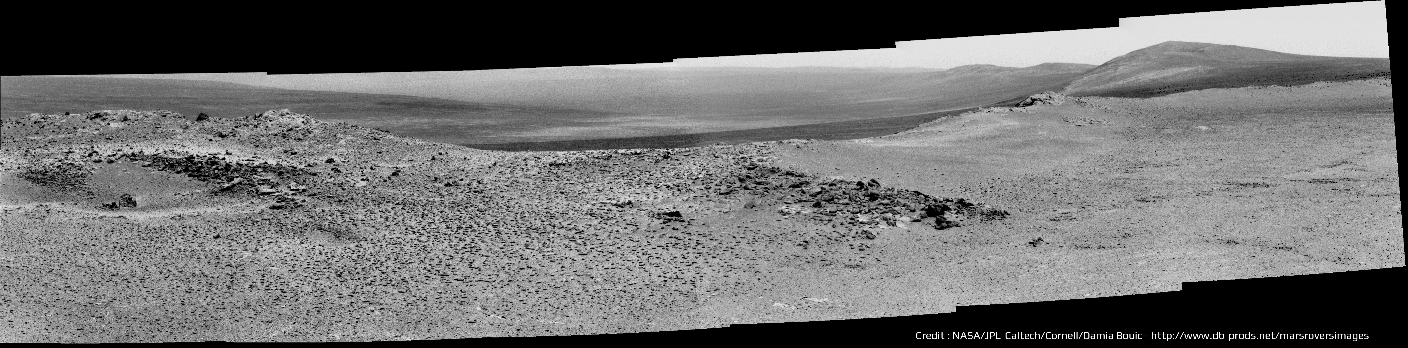 The navcam shot, after a quick drive. Lovely ripples there :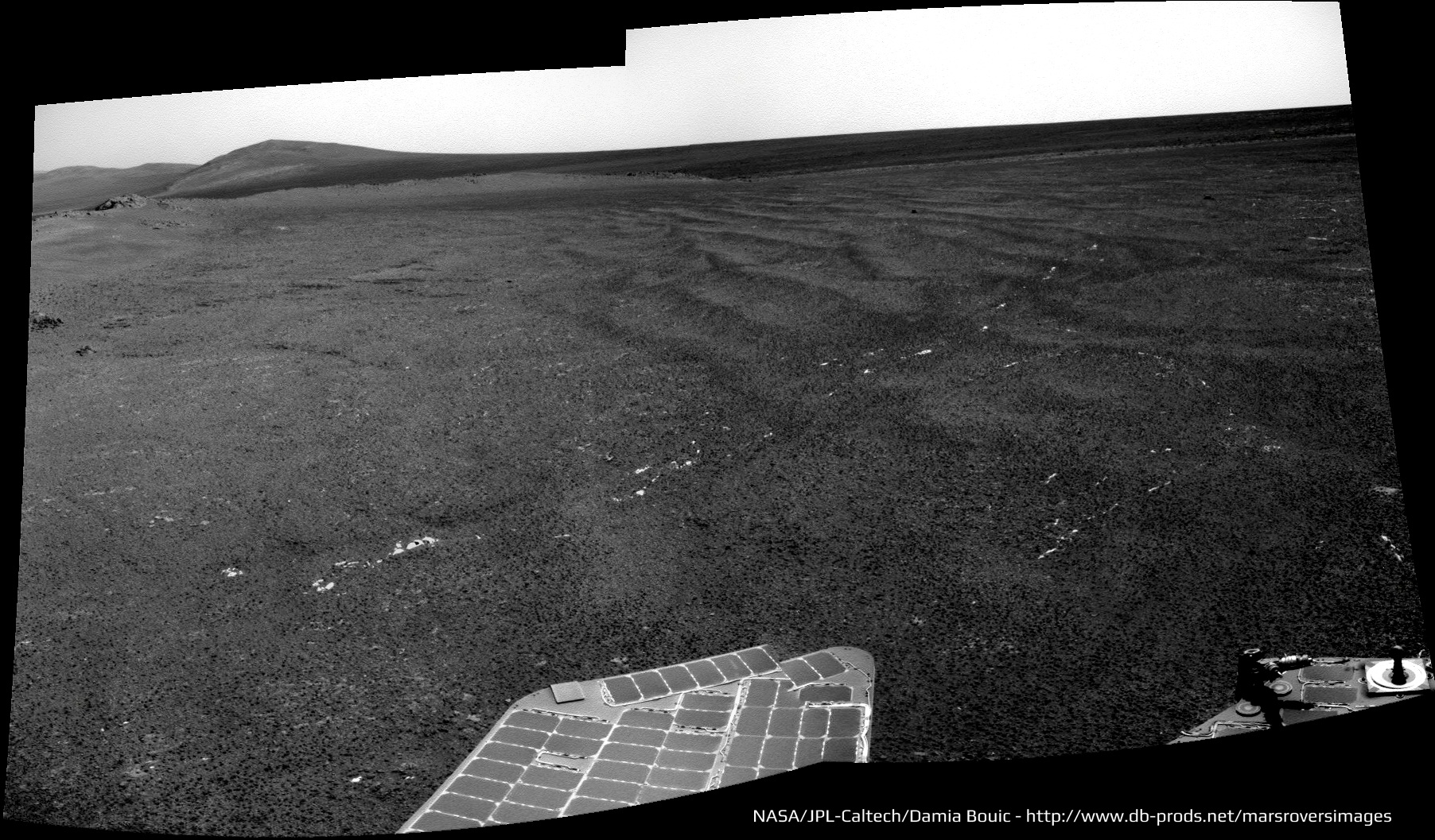 And the drive direction : 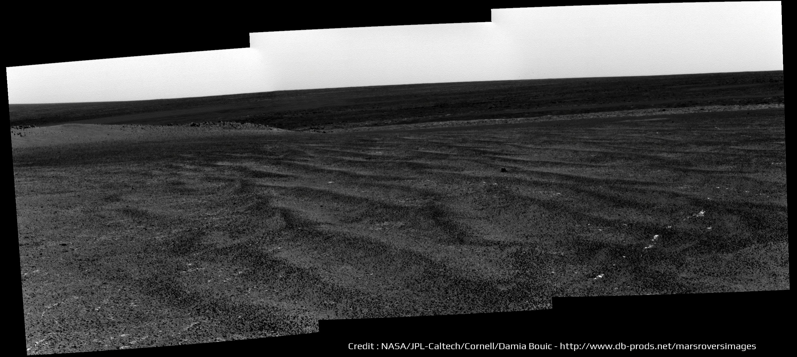
-------------------- |
|
|
|
|
Jun 13 2013, 11:09 AM
Post
#175
|
|
|
Senior Member Group: Moderator Posts: 4279 Joined: 19-April 05 From: .br at .es Member No.: 253 |
If I'm reading correctly, two 6x1 colour mosaics were shot on sol 3335. This is the second one, taken (almost) at the end-of-drive. The first one is still on the downlink queue and was shot before the drive, 35m to the NE.
|
|
|
|
|
Jun 13 2013, 02:28 PM
Post
#176
|
||
|
Senior Member Group: Members Posts: 2998 Joined: 30-October 04 Member No.: 105 |
QUOTE (Serpens) The probable gypsum veins in this remnant of the rim are more interesting. The rim has overrun by plains material, which means that there was massive erosion of the NW edge of Endeavour prior to that event. But... There are so many clues and questions at this line of outcrops. We got started on understanding the basics of the history of this area with the work at Cape York and we need to be following up and tying many things together as we walk this outcrop. For example, what is the story behind the contact and outcrop at Sutherland Point? http://www.unmannedspaceflight.com/index.p...st&p=200875 What is the lithology and nature of the several rock types seen at that site? No need to do detailed APXS or MI studies, simple Pancam Systematic Foreground or Color Clast Survey images will speak volumes. At Knobby Head, what are the similarities and differences in the (apparent) Impactite seen at CY and here? (Attached image) Admittedly, there are time constraints in getting to Cape Trib, but it is good field practice to connect the dots was we go. On the dipping strata present here, the more deeply eroded the outcrop is and the lower in the section we can look. And this doesn't even touch on the importance of understanding the Meridiani Onlap (ie, the contact between the Endeavour strata and the post-Endeavour strata). Or the enigma of the gypsum-filled fractures that are prevalent here. So much to do, so little time... --Bill
Attached thumbnail(s)
-------------------- |
|
|
|
|
|
|
Jun 14 2013, 09:50 AM
Post
#177
|
|
|
Senior Member Group: Members Posts: 1619 Joined: 12-February 06 From: Bergerac - FR Member No.: 678 |
Sol 3335, wider Navcam panorama :
-------------------- |
|
|
|
|
Jun 14 2013, 09:53 PM
Post
#178
|
|
|
Senior Member Group: Members Posts: 3516 Joined: 4-November 05 From: North Wales Member No.: 542 |
I have a question about 'contouring'. Walking in the hills it's not uncommon to follow a contour to avoid losing height. How much does this come into play in rover operations? I note that we have gone round the top side of Nobby's Head and so kept on the level.
|
|
|
|
|
Jun 15 2013, 12:04 AM
Post
#179
|
|
 Senior Member Group: Members Posts: 4252 Joined: 17-January 05 Member No.: 152 |
The slopes are pretty subtle here and I think they could have done a direct route if they chose to. I think the approach to Nobby is mainly to do stereo imaging in case they need to use it for winter.
Also, they talked about possibly driving around and approaching from the west side of Solander, which would be easier than driving up from the east or north. |
|
|
|
|
Jun 15 2013, 03:45 AM
Post
#180
|
||
|
Senior Member Group: Members Posts: 2998 Joined: 30-October 04 Member No.: 105 |
Hot off the wire... the central portion of an L257 Pancam panorama of Nobbys Head on Sol-3335:
--Bill
Attached thumbnail(s)
-------------------- |
|
|
|
|
|
|

|
Lo-Fi Version | Time is now: 22nd June 2024 - 02:35 PM |
|
RULES AND GUIDELINES Please read the Forum Rules and Guidelines before posting. IMAGE COPYRIGHT |
OPINIONS AND MODERATION Opinions expressed on UnmannedSpaceflight.com are those of the individual posters and do not necessarily reflect the opinions of UnmannedSpaceflight.com or The Planetary Society. The all-volunteer UnmannedSpaceflight.com moderation team is wholly independent of The Planetary Society. The Planetary Society has no influence over decisions made by the UnmannedSpaceflight.com moderators. |
SUPPORT THE FORUM Unmannedspaceflight.com is funded by the Planetary Society. Please consider supporting our work and many other projects by donating to the Society or becoming a member. |
|


