

Heading south from Cape York, Opportunity's post-conjunction adventures / Sol 3291 - 3387 |

  |
Heading south from Cape York, Opportunity's post-conjunction adventures / Sol 3291 - 3387 |
 Jun 23 2013, 12:26 PM Jun 23 2013, 12:26 PM
Post
#211
|
|
|
Solar System Cartographer  Group: Members Posts: 10227 Joined: 5-April 05 From: Canada Member No.: 227 |
Wowsers! Looks like we're down on the plains again:
http://www.midnightplanets.com/web/MERB/im...MP0703L0M1.html Phil -------------------- ... because the Solar System ain't gonna map itself.
Also to be found posting similar content on https://mastodon.social/@PhilStooke Maps for download (free PDF: https://upload.wikimedia.org/wikipedia/comm...Cartography.pdf NOTE: everything created by me which I post on UMSF is considered to be in the public domain (NOT CC, public domain) |
 |
 
|
|
Jun 23 2013, 12:26 PM
Post
#212
|
|
|
Senior Member Group: Members Posts: 3008 Joined: 30-October 04 Member No.: 105 |
Looks like she's folded her tent and is headed Southwardish.
And we never found out about Gibber_Earless...  --Bill -------------------- |
|
|
|
|
Jun 23 2013, 12:51 PM
Post
#213
|
|
|
Solar System Cartographer Group: Members Posts: 10227 Joined: 5-April 05 From: Canada Member No.: 227 |
"There are some 20 post-Esperance named sites and of these 8-9 are the current crop. The problem is keeping up with things in the long run."
That's what I am trying to do, to record, maybe not all these names, but as many as is feasible, and locate them on maps. Earlier ones come out of the Analyst's Notebook, but I try to keep up with current ones as well. But it's a lot of work! Phil -------------------- ... because the Solar System ain't gonna map itself.
Also to be found posting similar content on https://mastodon.social/@PhilStooke Maps for download (free PDF: https://upload.wikimedia.org/wikipedia/comm...Cartography.pdf NOTE: everything created by me which I post on UMSF is considered to be in the public domain (NOT CC, public domain) |
|
|
|
|
Jun 23 2013, 02:03 PM
Post
#214
|
|
|
Senior Member Group: Members Posts: 3008 Joined: 30-October 04 Member No.: 105 |
It is a lot of work. Not only the identifying the named sites, but also locating them on polar reprojections of Nav- and PanCam panoramas (if available) and thence to HiRISE images and HiRISE-derived maps. As you well know. The BIG problem is not so much the named sites, but the multitude of "Foreground Quarter" and "Clast Survey"and "one-shot drive-by" images. Even innocuous images like FHazCam and RHazCam shots are useful for soil texture info.
It never ends. Thank goodness... --Bill -------------------- |
|
|
|
|
Jun 23 2013, 10:17 PM
Post
#215
|
||
|
Senior Member Group: Members Posts: 3008 Joined: 30-October 04 Member No.: 105 |
Here is a best guesstimate of where Oppy was on Sols-3342-3344-3346:
The graben-- fault block-- that she passed East of on exiting Nobbys Head bench may show up on the azimuth 270* partial Navcam pan. --Bill
Attached thumbnail(s)
-------------------- |
|
|
|
|
|
|
Jun 24 2013, 04:22 AM
Post
#216
|
|||
|
Senior Member Group: Members Posts: 3008 Joined: 30-October 04 Member No.: 105 |
Here is a 5x1 pano of that Sol-3346 Navcam sequence with a cropped and rotated portion of the above location image, showing the suspected graben/fault block. Note especially the unusual textures of the weathered rock in the "fault plane".
--Bill Added: A 4x1 pano of the above sequence (left the fifth "northmost" panel off) showing the suspected fault (but not as well as I'd hoped). --b
Attached thumbnail(s)
-------------------- |
||
|
|
|
||
|
Jun 24 2013, 09:49 AM
Post
#217
|
|
 Senior Member Group: Members Posts: 1619 Joined: 12-February 06 From: Bergerac - FR Member No.: 678 |
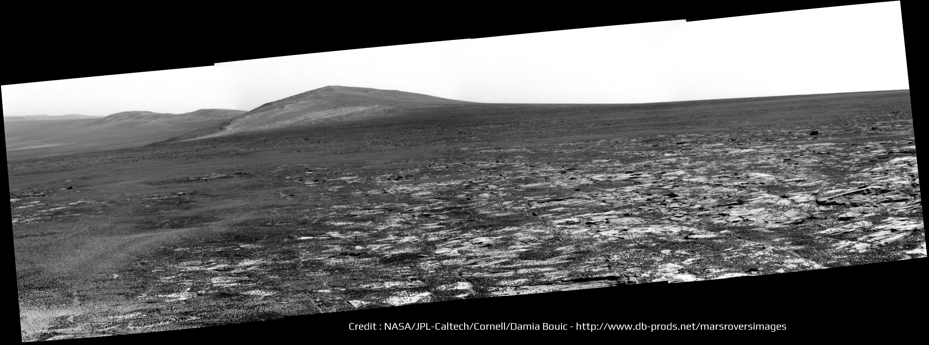
Sol 3346 panoramics :
-------------------- |
|
|
|
|
Jun 24 2013, 02:07 PM
Post
#218
|
|
|
Senior Member Group: Members Posts: 3008 Joined: 30-October 04 Member No.: 105 |
Now these sites are going to be interesting:
Gibber Earless http://www.midnightplanets.com/web/MERB/im...3P2597R2M1.html Signal Head http://www.midnightplanets.com/web/MERB/im...3P2391R2M1.html Got stereo pairs, waiting for the color imagery. --Bill -------------------- |
|
|
|
|
Jun 24 2013, 03:54 PM
Post
#219
|
|
|
Senior Member Group: Moderator Posts: 4279 Joined: 19-April 05 From: .br at .es Member No.: 253 |
QUOTE (Ant103 @ Jun 24 2013, 11:49 AM)  Sol 3346 panoramics : Love it! And the view will improve drive after drive. |
|
|
|
|
Jun 24 2013, 04:47 PM
Post
#220
|
||
|
Solar System Cartographer Group: Members Posts: 10227 Joined: 5-April 05 From: Canada Member No.: 227 |
This is a cleaned-up view of Solander Point (and Cape Tribulation peeking over its shoulder) - cleaned up by merging the two most recent pancam images to improve signal to noise (mostly JPEG artifacts). There should be plenty of interesting things to look at - I like the long continuous light-toned stratum at the top of the brighter area. (Hopefully it's not just a big dust drift!)
EDIT - see following post - Bill's right of course - looks like the Meridiani plains, AKA Burns Formation, slope upwards a bit where they are plastered onto the tip of the point. But we presumably have to go higher up to get the slopes we need plus the old Endeavour rim material. Phil
-------------------- ... because the Solar System ain't gonna map itself.
Also to be found posting similar content on https://mastodon.social/@PhilStooke Maps for download (free PDF: https://upload.wikimedia.org/wikipedia/comm...Cartography.pdf NOTE: everything created by me which I post on UMSF is considered to be in the public domain (NOT CC, public domain) |
|
|
|
|
|
|
Jun 24 2013, 07:42 PM
Post
#221
|
||
|
Senior Member Group: Members Posts: 3008 Joined: 30-October 04 Member No.: 105 |
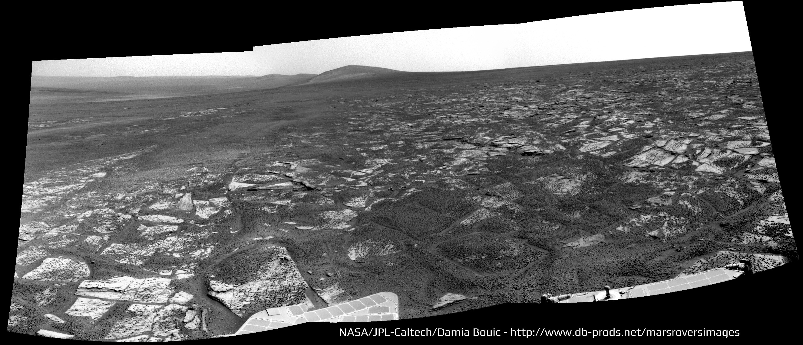
The bright area is the usual Meridiani Overlap/Bench that crops up at the foot of the hills and the continuous stratum may be simply outcrops superimposed along the line of sight. Here is a cropped and inverted ("North" is down) HiRISE image of the target area:
--Bill
Attached thumbnail(s)
-------------------- |
|
|
|
|
|
|
Jun 24 2013, 08:32 PM
Post
#222
|
|
|
Senior Member Group: Members Posts: 3516 Joined: 4-November 05 From: North Wales Member No.: 542 |
It's very nice to have the view ahead and the view from overhead consecutively in the last two posts. Even better would be if someone could identify a few key points in both images to help the rest of us get our bearings. I have to admit I'm struggling a bit to find sure identifications when it comes to the details.
|
|
|
|
|
Jun 24 2013, 10:39 PM
Post
#223
|
|||
|
Senior Member Group: Members Posts: 3008 Joined: 30-October 04 Member No.: 105 |
Good idea. It's hard to tell "Who's on First or What's on Second" without a scorecard.
First: An annotated and clarified image from Arvidson, et al. Second: Phil's "solander_cleaned" image and a HiRISE image, shamelessly annotated. "HTH" --Bill
Attached thumbnail(s)
-------------------- |
||
|
|
|
||
|
Jun 25 2013, 09:48 AM
Post
#224
|
||
 Senior Member Group: Members Posts: 1089 Joined: 19-February 05 From: Close to Meudon Observatory in France Member No.: 172 |
QUOTE (Bill Harris @ Jun 25 2013, 12:39 AM) First: An annotated and clarified image from Arvidson, et al. Second: Phil's "solander_cleaned" image and a HiRISE image, shamelessly annotated. --Bill What an interesting geological site ! I hope they will have some time left to climb a little, even up to Solander Point if they can... The view from up there on the crater and surrounding plains should be gorgeous ! Maybe that the rim of Bopolu crater on the south-west will be also visible from this new vantage point 
Bopolu Crater, as seen by Opportunity, Sol 2195 |
|
|
|
|
|
|
Jun 25 2013, 08:44 PM
Post
#225
|
||
 Senior Member Group: Moderator Posts: 3431 Joined: 11-August 04 From: USA Member No.: 98 |
Special treat today: at least part of the sol 3348 drive direction mosaic is in stereo color (L27R12).
Attached thumbnail(s)
|
|
|
|
|
|
|

|
Lo-Fi Version | Time is now: 24th September 2024 - 08:24 AM |
|
RULES AND GUIDELINES Please read the Forum Rules and Guidelines before posting. IMAGE COPYRIGHT |
OPINIONS AND MODERATION Opinions expressed on UnmannedSpaceflight.com are those of the individual posters and do not necessarily reflect the opinions of UnmannedSpaceflight.com or The Planetary Society. The all-volunteer UnmannedSpaceflight.com moderation team is wholly independent of The Planetary Society. The Planetary Society has no influence over decisions made by the UnmannedSpaceflight.com moderators. |
SUPPORT THE FORUM Unmannedspaceflight.com is funded by the Planetary Society. Please consider supporting our work and many other projects by donating to the Society or becoming a member. |
|


