Lakes in the limelight, the 2013 image bonanza continues |

  |
Lakes in the limelight, the 2013 image bonanza continues |
 Dec 27 2016, 06:47 AM Dec 27 2016, 06:47 AM
Post
#121
|
||
 Senior Member  Group: Members Posts: 2530 Joined: 20-April 05 Member No.: 321 |
I think there's a lot of subtle detail here that might be hidden from the eye.
I took the "summer clouds animation" (PIA21051: Watching Summer Clouds on Titan) and constructed a rough median frame by computing the pixelwise medians from the first, middle, and last frames. Then, I created a new animation which subtracts the median from each of the frames in the original work by Jason Perry. I think this makes subtle polar clouds (fog banks?) much more obvious: I count at least nine at one point. This also makes the rotation of the winds over a large area around the pole quite evident. In order to post here, I needed to shrink the animation 4x I think the key details are still obvious.
Attached thumbnail(s)
|
|
 |
 
|
|
|
Dec 28 2016, 04:06 AM
Post
#122
|
||
 Lord Of The Uranian Rings Group: Members Posts: 798 Joined: 18-July 05 From: Plymouth, UK Member No.: 437 |
Very neat trick, J. I wish I had thought of that!
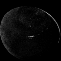
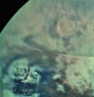
Conversely, stacking the frames brings out subtle details in the shorelines of the lakes and within the bright evaporite:
-------------------- |
|
|
|
|
|
|
Dec 28 2016, 04:28 AM
Post
#123
|
|
|
Senior Member Group: Members Posts: 2530 Joined: 20-April 05 Member No.: 321 |
Processing my own astrophotography falls, usually, into one of two modes: Deep sky objects, with incredible detail that is usually very subtle, and planetary objects, where the effects of the Earth's atmosphere is the major obstacle. In my version, Ian, and yours, we basically tackled this data set in those two ways. I used the median-subtraction to bring out faint details, and you used image stacking to compensate for the blurring effects of the atmosphere (in this case, Titan's).
This is basically a 3-D dataset, so there are many ways to rework it. Perhaps we've barely scratched the surface. |
|
|
|
|
Dec 28 2016, 06:45 AM
Post
#124
|
|
|
Member Group: Members Posts: 315 Joined: 1-October 06 Member No.: 1206 |
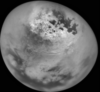
This beautiful image seems to cover a few areas that, to the best of my knowledge, have NOT been covered by radar swaths.
I see several sizeable lakes in these areas. Have they been named? P |
|
|
|
|
Dec 28 2016, 01:01 PM
Post
#125
|
|
|
Senior Member Group: Members Posts: 3516 Joined: 4-November 05 From: North Wales Member No.: 542 |
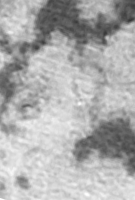
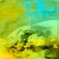
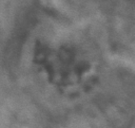
Another thing I've noticed in Ian's stacked image is the suggestion of a large circular feature, similar in size to Menrva and to the northeast of it. Comparing just by eye with the Titan map on Ciclops I estimate its position as very approximately LAT+45 LON 70. The circle itself is brightish and its interior shows stronger light and dark mottling than surrounding areas at the same latitude.
EDIT: Here is a crop of the feature I'm referring to -
Attached image(s)
|
|
|
|
|
Dec 29 2016, 06:42 PM
Post
#126
|
|
|
Senior Member Group: Members Posts: 2530 Joined: 20-April 05 Member No.: 321 |
Thanks for the addition of the close-up, ngunn. That is an intriguing feature. It seems like some sort of combination of volcanic and lake formation might be involved.
|
|
|
|
|
Dec 29 2016, 10:24 PM
Post
#127
|
||
|
Member Group: Members Posts: 699 Joined: 1-April 08 From: Minnesota ! Member No.: 4081 |
QUOTE (ngunn @ Dec 24 2016, 05:34 PM)  Agreed, that's a superb view. The channel connecting Jingpo Lacus to Kraken Mare is particularly striking. Also the view of the 'toe of Italy' area, not well imaged by SAR, is pretty good. It could be a separate lake linked to Kraken by a similar channel. I wonder if the channel going from Jingpo to Kraken is more the result of the lower resolution of the ISS image. We have good views of the area from the T 25 SAR and a very nice denoised view of the beginning of the channel from Antoine Lucas version of Jingpo Lacus shown in Photojournal here: http://photojournal.jpl.nasa.gov/catalog/PIA19053 (BTW the caption for the image contains an error stating The three leftmost image pairs show bays and spits of land in Ligea Mare, one of Titan's large hydrocarbon seas. The rightmost pair shows a valley network along Jingpo Lacus, one of Titan's larger northern lakes. Id suggest this should read: the two left most image pairs show bays and spits of land in Ligeia Mare, the next pair are of Jingpo Lacus and the rightmost pair show a valley network along Kraken. Anyway the figure below overlays the T-25 SAR on IAN Rs processed mosaic from UMSF (sharpened and enhanced) and identifies seas, islands and more obvious channels. Changes may have occurred since the T-25 SAR to dampen the broad area making it appear as a channel, but a continuous channel it appears not likely.
|
|
|
|
|
|
|
Dec 29 2016, 10:49 PM
Post
#128
|
|
|
Senior Member Group: Members Posts: 3516 Joined: 4-November 05 From: North Wales Member No.: 542 |
There is a big difference between what the RADAR sees and the near IR images. I'm not sure which is the best guide to the topography or the drainage.
|
|
|
|
|
Dec 29 2016, 10:54 PM
Post
#129
|
|
|
Senior Member Group: Members Posts: 3516 Joined: 4-November 05 From: North Wales Member No.: 542 |
Refering to the circular feature: maybe impact should be considered too?
|
|
|
|
|
Dec 30 2016, 04:58 AM
Post
#130
|
||||
|
Lord Of The Uranian Rings Group: Members Posts: 798 Joined: 18-July 05 From: Plymouth, UK Member No.: 437 |
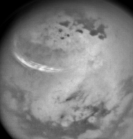
QUOTE (ngunn @ Dec 29 2016, 10:54 PM) Refering to the circular feature: maybe impact should be considered too? This feature has intrigued me for some time, ever since I spied it on a medium range shot from 2013:
Nicknaming it the 'Bullseye', I spotted it again on the VIMS mosaic taken during the T-114 flyby; this is a crop of an undistorted version of PIA20016:
Finally, here is our region of interest with the topographic map (courtesy of Ralph Lorenz, et al) lain over the ISS basemap PIA20713:
It would appear that the 'Bullseye' is possibly a depression, perhaps even an ancient impact crater that has degraded over time. It may also be analogous to Hotei Regio, which is suspected to be a dry lake bed, harking back to seasonal conditions that favored temperate latitudes. Who knows?  -------------------- |
|||
|
|
|
|||
|
Jan 3 2017, 08:17 AM
Post
#131
|
||
|
Lord Of The Uranian Rings Group: Members Posts: 798 Joined: 18-July 05 From: Plymouth, UK Member No.: 437 |
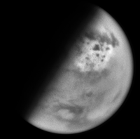
With the new year comes changes on Titan: just look at the size of the cloud bands girding the upper latitudes!
-------------------- |
|
|
|
|
|
|
Jan 3 2017, 04:54 PM
Post
#132
|
|
|
Senior Member Group: Members Posts: 2530 Joined: 20-April 05 Member No.: 321 |
QUOTE (Ian R @ Jan 3 2017, 01:17 AM) With the new year comes changes on Titan: just look at the size of the cloud bands girding the upper latitudes! Cloud formation can be a sort of binary switch that makes visible the variations in relative humidity that are otherwise invisible. One thing that can come out of this beautiful and mesmerizing data set is an understanding of Titan weather, using this sparse "boolean" data to interpolate/extrapolate to a wider range of times, places, conditions, etc. In the animation I made showing the polar clouds, it would be particularly interesting to identify the times and places where clouds/fog began. It seems like perhaps a weather front is moving over lakes, causing clouds to initiate when it crosses over them. But maybe I'm primed to expect this because I used to live near and downwind of the Great Lakes on Earth. |
|
|
|
|
Jan 4 2017, 04:42 AM
Post
#133
|
|
 Member Group: Members Posts: 610 Joined: 23-February 07 From: Occasionally in Columbia, MD Member No.: 1764 |
QUOTE (JRehling @ Jan 3 2017, 11:54 AM) Cloud formation can be a sort of binary switch that makes visible the variations in relative humidity that are otherwise invisible. One thing that can come out of this beautiful and mesmerizing data set is an understanding of Titan weather, using this sparse "boolean" data to interpolate/extrapolate to a wider range of times, places, conditions, etc. You're quite right - even austere datasets such as we have here can be interpreted in a probabilistic way, using Bayesian reasoning / Monte Carlo methods - the same is true of the Boolean question of 'are there waves on the sea surface on Titan (you can have calm days during the windy season and vice versa, so perfect/accurate measurement is perhaps less important than frequent measurement) Another example - not related to Titan - is whether rocks moved or not https://www.lpl.arizona.edu/~rlorenz/climat...e_racetrack.pdf |
|
|
|
|
Jan 4 2017, 10:13 PM
Post
#134
|
|
 Senior Member Group: Members Posts: 1887 Joined: 20-November 04 From: Iowa Member No.: 110 |
|
|
|
|
|
Feb 19 2017, 04:24 PM
Post
#135
|
|
|
Senior Member Group: Members Posts: 3516 Joined: 4-November 05 From: North Wales Member No.: 542 |
More superb views of lakes and clouds today: https://saturnraw.jpl.nasa.gov/multimedia/i...8/N00277002.jpg
|
|
|
|
|

|
Lo-Fi Version | Time is now: 20th April 2024 - 01:30 AM |
|
RULES AND GUIDELINES Please read the Forum Rules and Guidelines before posting. IMAGE COPYRIGHT |
OPINIONS AND MODERATION Opinions expressed on UnmannedSpaceflight.com are those of the individual posters and do not necessarily reflect the opinions of UnmannedSpaceflight.com or The Planetary Society. The all-volunteer UnmannedSpaceflight.com moderation team is wholly independent of The Planetary Society. The Planetary Society has no influence over decisions made by the UnmannedSpaceflight.com moderators. |
SUPPORT THE FORUM Unmannedspaceflight.com is funded by the Planetary Society. Please consider supporting our work and many other projects by donating to the Society or becoming a member. |
|