Dawn's first orbit, including RC3, March 6, 2015- June 15, 2015 |

  |
Dawn's first orbit, including RC3, March 6, 2015- June 15, 2015 |
 May 19 2015, 05:51 PM May 19 2015, 05:51 PM
Post
#241
|
|
|
Member  Group: Members Posts: 148 Joined: 9-August 11 From: Mason, TX Member No.: 6108 |
Just to keep other causes in the discussion, we can't rule out some not-yet-obvious circumstance leading to secondary ejecta craters. But I do think the highly localized borders for some of these pits does speak to flows rather than ejecta. And other volatile materials than water could be at work as well. The Sander Crater example is similar only by possible mechanism; the soluble material there may have had a much higher temperature of sublimation/vaporization than water. In fact, I've seen solder blobs that pulled into such shapes; other volatile materials had nothing to do with the puddling behavior of the melted material.
-------------------- --
Don |
 |
 
|
|
May 20 2015, 04:20 PM
Post
#242
|
|
 Member Group: Members Posts: 423 Joined: 13-November 14 From: Norway Member No.: 7310 |
Yep, the bright spot is in the latest navigation images (OpNav 8). Image quality is pretty poor, though.
-------------------- |
|
|
|
|
May 20 2015, 05:15 PM
Post
#243
|
||
|
Senior Member Group: Members Posts: 2346 Joined: 7-December 12 Member No.: 6780 |
For convenience, the bright spot 8-fold magnified, and brightness-stretched in a nonlinear way, darker parts mapped to black:
|
|
|
|
|
|
|
May 20 2015, 05:25 PM
Post
#244
|
|
 Administrator Group: Admin Posts: 5172 Joined: 4-August 05 From: Pasadena, CA, USA, Earth Member No.: 454 |
Personally I'm more than happy to accept lots of JPEG compression artifacts in exchange for relatively quick release of new images. So far Ceres has been so much better than Vesta in terms of image release.
-------------------- My website - My Patreon - @elakdawalla on Twitter - Please support unmannedspaceflight.com by donating here.
|
|
|
|
|
May 20 2015, 05:39 PM
Post
#245
|
|
 Member Group: Members Posts: 291 Joined: 29-December 05 From: Ottawa, ON Member No.: 624 |
We are finally at the point where we can't get all of Ceres in a single frame, so quality is amazing! It wasn't that long ago were were stretching to death 20 pixel wide images.
|
|
|
|
|
May 20 2015, 05:40 PM
Post
#246
|
|
 Member Group: Members Posts: 715 Joined: 3-January 08 Member No.: 3995 |
It's puzzling, though, that the associated TIF images have the same JPG artifacts. One would think they would use unaltered images for the ~1-meg files.
|
|
|
|
|
May 20 2015, 05:55 PM
Post
#247
|
|
 Senior Member Group: Members Posts: 2530 Joined: 20-April 05 Member No.: 321 |
I thought I'd inject a comparison between Ceres' bright spots and albedo patterns that we've seen up-close on Phobos. Eg,
http://photojournal.jpl.nasa.gov/catalog/PIA10368 Phobos is of comparable distance from the Sun, and is also dark with bright spots. We can see that the bright areas underlie the dark surface and are exposed by combinations of impact cratering and downslope flow. We also see that craters within craters can create arbitrarily fine detail. We also see asymmetries that might not, a priori, be expected: Bright spots at certain places on a rim, but not in others, and bright patches where two causes of incline add (e.g., the upslope wall of a crater within Stickney), but no bright patches where two causes of incline cancel out (the other side of that crater within Stickney). Overall, there is a simple layering of dark over light, and physical exposure of the ice happens for two simple reasons (impact and downslope mass movement), with anisotropies in topography causing boundaries that appear complex. This seems like a prominent model to consider for Ceres' bright spots until better observations show the nuances of the bright spot boundaries. |
|
|
|
|
May 20 2015, 06:30 PM
Post
#248
|
|
 Senior Member Group: Moderator Posts: 3233 Joined: 11-February 04 From: Tucson, AZ Member No.: 23 |
QUOTE (Gladstoner @ May 20 2015, 10:40 AM)  It's puzzling, though, that the associated TIF images have the same JPG artifacts. One would think they would use unaltered images for the ~1-meg files. It's possible that they were returned as lossy-compressed images. These were opnavs after all, needed more for navigation than for science, so fine surface details aren't as important as seeing where the limb is. I know with Cassini we have the option to use that or lossless compression. I always use lossless compression because Titan's atmosphere makes my data blurry enough... -------------------- &@^^!% Jim! I'm a geologist, not a physicist!
The Gish Bar Times - A Blog all about Jupiter's Moon Io |
|
|
|
|
May 20 2015, 07:17 PM
Post
#249
|
||
|
Member Group: Members Posts: 715 Joined: 3-January 08 Member No.: 3995 |
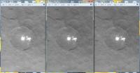
QUOTE (volcanopele @ May 20 2015, 01:30 PM) It's possible that they were returned as lossy-compressed images. These were opnavs after all, needed more for navigation than for science, so fine surface details aren't as important as seeing where the limb is. I know with Cassini we have the option to use that or lossless compression. I always use lossless compression because Titan's atmosphere makes my data blurry enough... I thought that might be the case, but the images in the recent animated GIF appear to be unaltered, while images selected from the same sequence and released in TIF and JPG format are degraded. A comparison, from left to right, are GIF (movie frame), TIF, and JPG:
I'm grateful they released that movie in the original quality. |
|
|
|
|
|
|
May 20 2015, 07:30 PM
Post
#250
|
|
|
Administrator Group: Admin Posts: 5172 Joined: 4-August 05 From: Pasadena, CA, USA, Earth Member No.: 454 |
It's horrible but true that the TIF versions of images at Photojournal are sometimes made from JPEG originals. It was probably provided to JPL by the FC team as a JPEG. Now, JPL could have just grabbed a still frame from the animation and posted that instead, but on missions there are agreements about different organizations having to post the same images at the same time, so it's not something they would ordinarily do.
-------------------- My website - My Patreon - @elakdawalla on Twitter - Please support unmannedspaceflight.com by donating here.
|
|
|
|
|
May 20 2015, 07:46 PM
Post
#251
|
|
|
Member Group: Members Posts: 423 Joined: 13-November 14 From: Norway Member No.: 7310 |
QUOTE (volcanopele @ May 20 2015, 08:30 PM) It's possible that they were returned as lossy-compressed images. These were opnavs after all, needed more for navigation than for science, so fine surface details aren't as important as seeing where the limb is. I know with Cassini we have the option to use that or lossless compression. I always use lossless compression because Titan's atmosphere makes my data blurry enough... I asked about that, and it seems that the answer is no: QUOTE Most of the compression artifacts you are seeing are the result of the conversion from raw data to JPEG format https://twitter.com/NASA_Dawn/status/601070407094009856 -------------------- |
|
|
|
|
May 20 2015, 07:53 PM
Post
#252
|
|
|
Senior Member Group: Members Posts: 1074 Joined: 21-September 07 From: Québec, Canada Member No.: 3908 |
While converting to JPEG, why didn't they specify "maximum quality"?
|
|
|
|
|
May 20 2015, 07:56 PM
Post
#253
|
||
 Senior Member Group: Members Posts: 1643 Joined: 5-March 05 From: Boulder, CO Member No.: 184 |
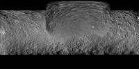
A simple map with a bright spot image projected onto the previously released map.
-------------------- Steve [ my home page and planetary maps page ]
|
|
|
|
|
|
|
May 20 2015, 09:28 PM
Post
#254
|
||
|
Member Group: Members Posts: 715 Joined: 3-January 08 Member No.: 3995 |
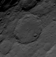
This crater floor fracture shows a little more detail in the new release:
|
|
|
|
|
|
|
May 20 2015, 09:42 PM
Post
#255
|
|
|
Senior Member Group: Members Posts: 3516 Joined: 4-November 05 From: North Wales Member No.: 542 |
QUOTE (JRehling @ May 20 2015, 06:55 PM) I thought I'd inject a comparison between Ceres' bright spots and albedo patterns that we've seen up-close on Phobos Excellent analysis (as ususal) but I'd be surprised if the bright material on the surface of Phobos was ice, so is it salt? If so that gets us somewhere. |
|
|
|
|

|
Lo-Fi Version | Time is now: 5th June 2024 - 06:43 PM |
|
RULES AND GUIDELINES Please read the Forum Rules and Guidelines before posting. IMAGE COPYRIGHT |
OPINIONS AND MODERATION Opinions expressed on UnmannedSpaceflight.com are those of the individual posters and do not necessarily reflect the opinions of UnmannedSpaceflight.com or The Planetary Society. The all-volunteer UnmannedSpaceflight.com moderation team is wholly independent of The Planetary Society. The Planetary Society has no influence over decisions made by the UnmannedSpaceflight.com moderators. |
SUPPORT THE FORUM Unmannedspaceflight.com is funded by the Planetary Society. Please consider supporting our work and many other projects by donating to the Society or becoming a member. |
|