Dawn's first orbit, including RC3, March 6, 2015- June 15, 2015 |

  |
Dawn's first orbit, including RC3, March 6, 2015- June 15, 2015 |
 May 22 2015, 08:16 AM May 22 2015, 08:16 AM
Post
#271
|
|
 Member  Group: Members Posts: 714 Joined: 3-January 08 Member No.: 3995 |
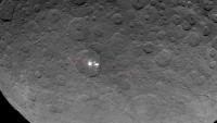
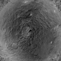
QUOTE (John Broughton @ May 22 2015, 12:56 AM)  "There appears to be a dark linear feature extending between the bright areas" It's part of the regional system of parallel grooves. This particular one extends well outside the crater rim on both sides and joins up with the most prominent groove about two crater diameters to the ESE. Some minor spots in the crater are not aligned, so I expect we'll see more cracks show up there as the resolution improves. Hmmm.... If these turn out to be fractures that run deep, they could potentially serve as conduits for ascending fluids. |
 |
 
|
|
May 22 2015, 08:53 AM
Post
#272
|
||
|
Junior Member Group: Members Posts: 45 Joined: 12-February 15 Member No.: 7397 |
QUOTE (Gladstoner @ May 22 2015, 08:16 AM) Hmmm.... If these turn out to be fractures that run deep, they could potentially serve as conduits for ascending fluids. Here's the general course of that fault.
Like the large mountain spot and another spot of small cones near that, the bright spots coincide exactly with fractures in the crust. The great length of some of these faults is a definite sign they run deep. |
|
|
|
|
|
|
May 22 2015, 11:27 AM
Post
#273
|
|
 Member Group: Members Posts: 495 Joined: 12-February 12 Member No.: 6336 |
The idea of ascending fluids is a good one, but still have to rise a very long distance against gravity.
If it on the other hand is water vapour, created by water boiling against the close-to-vacuum in a deep crack. Then vapour pressure would give it an extra boost enough to reach the surface. This could deposit salts and ice, either or both at the exit, so it does not solve the problem of what the bright material is composed of. But do at least make transportation to the surface more likely. |
|
|
|
|
May 22 2015, 05:06 PM
Post
#274
|
|
 Member Group: Members Posts: 423 Joined: 13-November 14 From: Norway Member No.: 7310 |
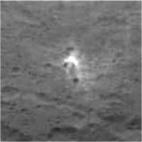
The latest released OpNav 8 image appears to have a much better quality, although it does not show the brightest spots (grr).
If we got more of the feature below (it should be a crater) over the weekend, that would be interesting. It might hold some important clues to all bright spots, including the brightest. 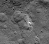
-------------------- |
|
|
|
|
May 22 2015, 05:40 PM
Post
#275
|
||
 Senior Member Group: Members Posts: 1627 Joined: 5-March 05 From: Boulder, CO Member No.: 184 |
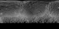
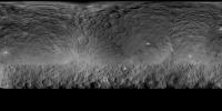
Here's a revised Ceres map, using 4 more recent images on top of the previous official map. Resolution now up to 4K.
I'll see about adding the OpNav posted just above. -------------------- Steve [ my home page and planetary maps page ]
|
|
|
|
|
|
|
May 22 2015, 06:56 PM
Post
#276
|
||
|
Junior Member Group: Members Posts: 48 Joined: 20-December 14 Member No.: 7370 |
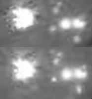
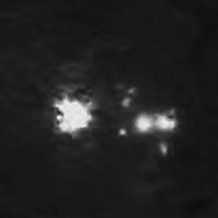
The two Spot5 Opnav8 images to date - with all the unfortunate jpeg compression artifacts.
The top half of the image has the more recent (5/21/2015) halfway to the limb image stretched and rotated to compare exactly with the first one (5/20/2015). As you can see it shows a bunch more small craters to the left of the big spot. A complex crater morphology such as this can produce any number of weird patterns. If it's an impact - I think it is going to take HAMO or LAMO picts to determine if it was one parent body and shrapnel/secondaries or a close rubble pile breakup. Given the direction of the dark right sided rays, I still vote for a single impact with a few direct secondaries.
|
|
|
|
|
|
|
May 22 2015, 06:58 PM
Post
#277
|
||
|
Senior Member Group: Members Posts: 1627 Joined: 5-March 05 From: Boulder, CO Member No.: 184 |
And here is the map with today's OpNav added.
-------------------- Steve [ my home page and planetary maps page ]
|
|
|
|
|
|
|
May 22 2015, 08:46 PM
Post
#278
|
|
|
Junior Member Group: Members Posts: 48 Joined: 20-December 14 Member No.: 7370 |
QUOTE (scalbers @ May 22 2015, 11:58 AM) And here is the map with today's OpNav added. Thanks - I like the maps scalbers - keep 'em coming! I have one item on my wish list - would it be possible add a second map with north and south polar projections? - the poles get so distorted in Mercator projections. |
|
|
|
|
May 22 2015, 10:07 PM
Post
#279
|
|
|
Member Group: Members Posts: 315 Joined: 1-October 06 Member No.: 1206 |
Hmm, hard to tell with that projection, but is the small white patch upper right (not sure if its one of the officially numbered patches) 'downrange' from the twin splotches?
 I know, probably trying to find patterns where none exist! I like the fracture[s] idea actually, that would be more interesting than just a low angle impact. P |
|
|
|
|
May 22 2015, 10:40 PM
Post
#280
|
|
|
Member Group: Members Posts: 714 Joined: 3-January 08 Member No.: 3995 |
A can of Diet Coke today had me thinking. We all have accidentally left a can of soda in the freezer. Long after a half hour (when it should be cold enough to drink, i.e. should have been taken out of the freezer), carbon dioxide begins to come out of solution as the water freezes. Eventually the can ruptures as the gas pressure becomes too great, and a very-syrup-rich slurry sprays into the freezer interior to make a fine mess.
Now back to Ceres. Assuming the body differentiated into a rocky core and icy mantle, could a similar process have happened within Ceres? Ice would first form near the surface and progressively freeze downward. Various volatiles (like the CO2 in the can) and cations & anions/dissolved salts (the syrup) would become more and more concentrated in the remaining brine. Over the age of the solar system, the water probably would have frozen out long ago, but there could still be remaining pockets of gas and possibly highly-concentrated brine. These would be *roughly* analogous to petroleum reservoirs on Earth in the way they permeate the substrates. Now, Ceres wouldn't rupture like a pop can, but some of the volatiles may eventually make their way to the surface (thanks to some minor tectonic adjustments due to an impact, perhaps?). The conduit at or near the surface would be marked with bright salt deposits. The extra brightness of the material could be due in part to micrometeoritic impacts on exposed transparent or translucent salts, kind of like the frosting that occurs when a similar material is sandblasted. Of course this could be completely wrong, but it seems to make the most sense to me. |
|
|
|
|
May 22 2015, 11:08 PM
Post
#281
|
||
|
Senior Member Group: Members Posts: 1627 Joined: 5-March 05 From: Boulder, CO Member No.: 184 |
Good idea Ken2 - I put together a quick procedure to make a polar image. Shapes are a bit distorted near the edge as I've yet to add the niceties of a stereographic projection - this should give an idea of things though. North pole is in the center and zero longitude should be on the top. The south pole is devoid of data on this map so I'm holding off on it for now.
That small white spot on the right pointed out by antipode (2 posts up) indeed looks interesting. It might be close to being on a great circle from the two brightest spots from what I can tell. Looking at the cylindrical map (5 posts up) in Celestia might help, though it should be pointed out the cylindrical map is in planetocentric coordinates and Celestia usually expects planetographic. I'm accounting for Ceres being an oblate spheroid in this manner. |
|
|
|
|
|
|
May 22 2015, 11:56 PM
Post
#282
|
||
|
Junior Member Group: Members Posts: 45 Joined: 12-February 15 Member No.: 7397 |
There are at least three possible volcanic cones associated with this spot. I've inverted the image so it is illuminated from above.
The spot lies on a fault line running from the top left to the bottom right corner, but is indistinct at this high sun angle. As far as I can tell, hills are at the centre of all spots, whether they lie within craters or not. |
|
|
|
|
|
|
May 23 2015, 03:12 AM
Post
#283
|
||
|
Member Group: Members Posts: 808 Joined: 10-October 06 From: Maynard Mass USA Member No.: 1241 |
My deconvolve program had a little fun with this JPGy file... but not the best of results (arrggg!)
I turned down the background to try to focus on the lighter stuff... its about 5x
Its obviously an abandoned asteroid mining operation ... nothing to see here .... move along people...  We shall have to wait for more RCx to HAMO to LAMO to WHAMO! -------------------- CLA CLL
|
|
|
|
|
|
|
May 23 2015, 05:22 AM
Post
#284
|
|
|
Member Group: Members Posts: 714 Joined: 3-January 08 Member No.: 3995 |
QUOTE (PDP8E @ May 22 2015, 10:12 PM) Its obviously an abandoned asteroid mining operation ... Anyone can see it's an Illudium Q-36 Explosive Space Modulator. |
|
|
|
|
May 23 2015, 06:34 AM
Post
#285
|
|
 Member Group: Members Posts: 813 Joined: 8-February 04 From: Arabia Terra Member No.: 12 |
I just think the whole of Ceres is like Vastitas Borealis on Mars. Regolith over a widespread layer of almost pure water ice. As with Mars, the most recent impacts reveal this ice. Over longer timescales the exposed ice sublimes away and eventually escapes Ceres.
|
|
|
|
|

|
Lo-Fi Version | Time is now: 24th April 2024 - 07:28 AM |
|
RULES AND GUIDELINES Please read the Forum Rules and Guidelines before posting. IMAGE COPYRIGHT |
OPINIONS AND MODERATION Opinions expressed on UnmannedSpaceflight.com are those of the individual posters and do not necessarily reflect the opinions of UnmannedSpaceflight.com or The Planetary Society. The all-volunteer UnmannedSpaceflight.com moderation team is wholly independent of The Planetary Society. The Planetary Society has no influence over decisions made by the UnmannedSpaceflight.com moderators. |
SUPPORT THE FORUM Unmannedspaceflight.com is funded by the Planetary Society. Please consider supporting our work and many other projects by donating to the Society or becoming a member. |
|