New Horizons: Near Encounter Phase |

  |
New Horizons: Near Encounter Phase |
 Jul 16 2015, 12:22 AM Jul 16 2015, 12:22 AM
Post
#571
|
|
|
Member  Group: Members Posts: 153 Joined: 20-December 14 From: Eastbourne, UK Member No.: 7372 |
QUOTE (EDG @ Jul 16 2015, 12:19 AM)  The canyon that we see on the edge of the righthand limb of the hi-res Charon image... where is that in the lower res image? Are we looking straight down onto it in the low-res image The best reference is the "Mordor" dark patch. In the high-res image the open square end of the depression points to about 4 O'Clock, in the low-res image it points to about half past nine. So it is about halfway between the western rim and the centre line of the hemisphere. The flat lighting makes it difficult to see. It does mean the huge crater/volcano in the centre of the low-res image is not visible in the latest image, though the rugged terrain on the eastern rim of that image suggests these are the foothills of that feature. The large cluster of what could be secondary craters here suggests it is an impact crater, though volcanic ejecta could cause secondary cratering also. |
 |
 
|
|
Jul 16 2015, 12:26 AM
Post
#572
|
||
|
Solar System Cartographer Group: Members Posts: 10183 Joined: 5-April 05 From: Canada Member No.: 227 |
And an attempt to match features. It is possible that the upper left valley on the limb in the latest image is feature F in the earliest view, but I'm not certain yet. To try to help track it, look at the bright spot inside the dark area... at left in the best image, at right in the lowest resolution image.
Phil
-------------------- ... because the Solar System ain't gonna map itself.
Also to be found posting similar content on https://mastodon.social/@PhilStooke Maps for download (free PD: https://upload.wikimedia.org/wikipedia/comm...Cartography.pdf NOTE: everything created by me which I post on UMSF is considered to be in the public domain (NOT CC, public domain) |
|
|
|
|
|
|
Jul 16 2015, 12:32 AM
Post
#573
|
||
 Senior Member Group: Members Posts: 1887 Joined: 20-November 04 From: Iowa Member No.: 110 |
Some possible matches between the color image and the latest
|
|
|
|
|
|
|
Jul 16 2015, 12:34 AM
Post
#574
|
|
|
Member Group: Members Posts: 153 Joined: 20-December 14 From: Eastbourne, UK Member No.: 7372 |
QUOTE (nprev @ Jul 16 2015, 01:04 AM) You are talking about an extremely improbable sequence of events, Sherbert, esp. so given the very small size of objects in the Pluto system. Not impossible, of course, but vanishingly unlikely, even more so given the remarkably symmetric, orderly orbital state of the system. I know, its seems like a very long list of maybes, but the system only survived because it beat the odds for its destruction. Something very particular ensured it's survival. |
|
|
|
|
Jul 16 2015, 12:50 AM
Post
#575
|
|
|
Junior Member Group: Members Posts: 77 Joined: 27-June 04 From: Queensland Australia Member No.: 90 |
QUOTE (nprev @ Jul 15 2015, 11:22 PM) Spectacular, John. That black smudge is smack dab on top of an elevated 'ropy' looking region, very different from the surrounding plains & peaks. That is very, very intriguing. Just a thought, but I can't help think in terms of the Antarctic dry valleys as a kind of water ice sublimation analogy. So will areas of higher ablation have a darker colour due to a gradual concentration of non volatiles? If we think about the sublimation process, maybe some tholin powder is being continually (seasonally/diurnally) entrained into the released gas, but the volatiles emission will be the dominant process. The resultant nitrogen snow will fall in areas of predominant deposition which may be lighter in colour. |
|
|
|
|
Jul 16 2015, 12:51 AM
Post
#576
|
|
|
Senior Member Group: Members Posts: 1887 Joined: 20-November 04 From: Iowa Member No.: 110 |
QUOTE (Sherbert @ Jul 15 2015, 07:34 PM) I know, its seems like a very long list of maybes, but the system only survived because it beat the odds for its destruction. Something very particular ensured it's survival. Neptune migrating outward captures objects in its resonances like Pluto and many other objects. Neptune encountering another planet causes its semi-major axis to jump would also result in the capture of objects in its resonances. Objects having close encounters with Neptune have their orbits altered (which can increase their eccentricity of inclination) but rarely enough to eject them in one encounter. Nearly 25 years ago someone claimed that the solar system once had a thousand Pluto-sized objects most of which were lost leaving Pluto and Triton as the remnants of the population. |
|
|
|
|
Jul 16 2015, 12:55 AM
Post
#577
|
|
|
Member Group: Members Posts: 126 Joined: 20-April 05 Member No.: 291 |
QUOTE (Phil Stooke @ Jul 15 2015, 07:26 PM) And an attempt to match features. It is possible that the upper left valley on the limb in the latest image is feature F in the earliest view, but I'm not certain yet. To try to help track it, look at the bright spot inside the dark area... at left in the best image, at right in the lowest resolution image. Phil Feature A should be present in the 3rd image as well. It would be helpful to mark the relative axis running from the end of the rift (H) through the loops below the dark splotch. It looks like it rotates clockwise about 120 degrees (through the 5 image sereis)? |
|
|
|
|
Jul 16 2015, 01:02 AM
Post
#578
|
|
|
Member Group: Members Posts: 890 Joined: 18-November 08 Member No.: 4489 |
back from dinner
QUOTE Wow...Shape from shaping I assume? yep , but that one was a very quick one i used a hipass first and only ONE solar angle the mountains on the right are TOO HIGH i am about to put together a 3 angle image so they should be a bit better -- for 15 min from garbing the image to posting the few shots |
|
|
|
|
Jul 16 2015, 01:08 AM
Post
#579
|
|
|
Senior Member Group: Members Posts: 2998 Joined: 30-October 04 Member No.: 105 |
QUOTE (Aldebaran @ Jul 15 2015, 06:55 PM) I think that one of the keys to understanding this terrain is understanding the physical properties of the various volatiles that dominate the surface and crust of Pluto. So... ...The geology of Pluto is obviously pretty complex. What are the possible stable mixtures? For example, are there methane hydrates/ clathrates. Yes. And add into this mix lithologies composed of usual silicates, et al, with the addition of the unusual mineral oxidane, which will prove to have unusual properties under the cryogenic conditions on Pluto, especially in the presence of the typical suite of gas giant gases under cryogenic conditions. This is a wonderfully strange little world. --Bill -------------------- |
|
|
|
|
Jul 16 2015, 02:10 AM
Post
#580
|
|
|
Junior Member Group: Members Posts: 80 Joined: 14-February 04 Member No.: 32 |
QUOTE (Ken2 @ Jul 15 2015, 07:02 PM) Yes, but lines are often a further eroded stage (for mesas at least), and the bumpy stuff to the upper right of the arrowed mesa is typical of eroded mesa terrain. I think the black whale dusted region vs the white heart terrain transition is at play here - perhaps all the dark terrain is higher elevation capped terrain, and the heart is eroded - and this appears to be a transition zone. I think the biggest question of the mountains - where they pushed up or did the material around them erode/sublimate away? If it is due to erosion does it really take internal heat to do that over long time periods or are we just seeing a body sublimating away with dusty (maybe Charon dust) capped areas slowing down the erosion? True, but I'm merely questioning your assertion that the darker "mesa material" has to be much harder. If it was much harder, there would be mountains around that had eroded off into points or ridges - but I would think they would be far fewer as once the mesa is gone, erosion would accelerate. The but the very low number of "mesa mountains" in this image seems to imply (to me) that that top material is NOT much harder - if at all. Otherwise I agree. -------------------- - Lars
|
|
|
|
|
Jul 16 2015, 02:14 AM
Post
#581
|
|
|
Solar System Cartographer Group: Members Posts: 10183 Joined: 5-April 05 From: Canada Member No.: 227 |
Hydra - I subsampled the released Lego Hydra back to its constituent pixel scale, and enlarged again in stages with a bit of judicious stretching where needed.
Phil 
-------------------- ... because the Solar System ain't gonna map itself.
Also to be found posting similar content on https://mastodon.social/@PhilStooke Maps for download (free PD: https://upload.wikimedia.org/wikipedia/comm...Cartography.pdf NOTE: everything created by me which I post on UMSF is considered to be in the public domain (NOT CC, public domain) |
|
|
|
|
Jul 16 2015, 02:17 AM
Post
#582
|
|
|
Junior Member Group: Members Posts: 21 Joined: 30-June 15 From: Brooklyn NY Member No.: 7543 |
QUOTE (matlac @ Jul 15 2015, 05:45 PM) Mesmerizing! Another great day to be alive. NH team during the broadcast were like a bunch of kids in a candy store. Charon is a total surprise and on par with Pluto as a crowd pleaser. We only have seen a glimpse of those two celestial bodies and we can already list a page full of different geological features... I hope Charonshine won't let us down. Since this photo was unveiled, I can't help myself to see the isolated mountains in the reddish "plains" as if they were "flooded" by the red material in some way (deposit, eolian sedimentation, name it). Your tentative colorization makes it even more visible. I agree with you about the the small ondulating features that looks like dunes. It will be really interesting when spectroscopy data, topography and other measures will be put together. About Charon's pole: I can't help but see a circular feature under the irregular dark matter. Probably an illusion as I see what I want to see. Can't wait until next press conference for more information. Matt Perhaps not dunes, but a continuation of the striations (associated with venting ala Enceladus?) partially buried in whatever deposition material makes up the flat terrain. |
|
|
|
|
Jul 16 2015, 02:34 AM
Post
#583
|
|
|
Senior Member Group: Members Posts: 1045 Joined: 17-February 09 Member No.: 4605 |
QUOTE (nprev @ Jul 16 2015, 12:30 AM) The fact that all of Pluto's moons are in circular, prograde, coplanar orbits strongly implies that they are either primordial or of impact origin. That would seem to rule out even a three-body capture with an ejected interloper to explain Charon. Of significance is that Pluto and Charon are mutually tidal locked. Conservation of angular momentum means that initially the two bodies were once much closer and there would have been quite significant tidal heating. Given that the orbits of Charon and the smaller moons are all in the same plane your suggestion of impact rather than capture would seem most logical. |
|
|
|
|
Jul 16 2015, 02:51 AM
Post
#584
|
|
|
Senior Member Group: Members Posts: 1276 Joined: 25-November 04 Member No.: 114 |
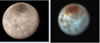
Charon reminds me of earth's moon!
|
|
|
|
|
Jul 16 2015, 02:57 AM
Post
#585
|
|
|
Junior Member Group: Members Posts: 48 Joined: 10-September 06 Member No.: 1129 |
Someone correct me if I'm wrong, but if Charon has a canyon 6-10km deep (as has been reported), that would make it one of the deepest canyons in the entire solar system -- in the same league as Earth's Mid-Atlantic ridge and Mars's Vallis Marineris. Considering the size of Charon, being in that company is even more stunning.
I'm going by this wikipedia page: https://en.wikipedia.org/wiki/List_of_large...he_Solar_System Is this accurate though? I thought Miranda had canyons as deep as 20 km... |
|
|
|
|

|
Lo-Fi Version | Time is now: 4th June 2024 - 01:12 AM |
|
RULES AND GUIDELINES Please read the Forum Rules and Guidelines before posting. IMAGE COPYRIGHT |
OPINIONS AND MODERATION Opinions expressed on UnmannedSpaceflight.com are those of the individual posters and do not necessarily reflect the opinions of UnmannedSpaceflight.com or The Planetary Society. The all-volunteer UnmannedSpaceflight.com moderation team is wholly independent of The Planetary Society. The Planetary Society has no influence over decisions made by the UnmannedSpaceflight.com moderators. |
SUPPORT THE FORUM Unmannedspaceflight.com is funded by the Planetary Society. Please consider supporting our work and many other projects by donating to the Society or becoming a member. |
|