Chang'e-4 farside landing mission |

  |
Chang'e-4 farside landing mission |
 Jun 13 2019, 08:14 PM Jun 13 2019, 08:14 PM
Post
#226
|
|
|
Solar System Cartographer  Group: Members Posts: 10151 Joined: 5-April 05 From: Canada Member No.: 227 |
Woohoo! (to coin a phrase). Check this out:
https://www.hou.usra.edu/meetings/planetdat...19/pdf/7030.pdf An abstract for the Planetary Data meeting with a map of Yutu 2's path and other information. Phil -------------------- ... because the Solar System ain't gonna map itself.
Also to be found posting similar content on https://mastodon.social/@PhilStooke Maps for download (free PD: https://upload.wikimedia.org/wikipedia/comm...Cartography.pdf NOTE: everything created by me which I post on UMSF is considered to be in the public domain (NOT CC, public domain) |
 |
 
|
|
Jun 13 2019, 10:59 PM
Post
#227
|
|
|
Solar System Cartographer Group: Members Posts: 10151 Joined: 5-April 05 From: Canada Member No.: 227 |
-------------------- ... because the Solar System ain't gonna map itself.
Also to be found posting similar content on https://mastodon.social/@PhilStooke Maps for download (free PD: https://upload.wikimedia.org/wikipedia/comm...Cartography.pdf NOTE: everything created by me which I post on UMSF is considered to be in the public domain (NOT CC, public domain) |
|
|
|
|
Jun 14 2019, 05:35 PM
Post
#228
|
||
|
Solar System Cartographer Group: Members Posts: 10151 Joined: 5-April 05 From: Canada Member No.: 227 |
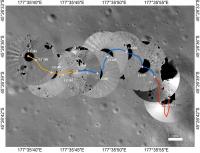
This is the map from the abstract (hopefully considered 'fair use' for educational purposes). It is an excellent illustration of how the rover is driven, not with a 'joystick' controller and live (slow-frame) TV like the Lunokhods, but by mapping a safe route from end-of-drive images like the various Mars rovers. Sites are labelled, so I will be updating the route map soon.
Phil
-------------------- ... because the Solar System ain't gonna map itself.
Also to be found posting similar content on https://mastodon.social/@PhilStooke Maps for download (free PD: https://upload.wikimedia.org/wikipedia/comm...Cartography.pdf NOTE: everything created by me which I post on UMSF is considered to be in the public domain (NOT CC, public domain) |
|
|
|
|
|
|
Jun 20 2019, 02:23 PM
Post
#229
|
||
|
Member Group: Members Posts: 156 Joined: 22-May 09 From: Ireland Member No.: 4792 |
Below, an attempt to match the doughnut track positions to Phil's map. But don't take them as literal, as with most tracks, they all look the same, so open to correction (it all has to do with viewing/estimating the angles between each doughnut track - some approach angles under 90 degrees, others over 90, not to mention the paths taken, where some are straight-like, some curvable).
John
Attached thumbnail(s)
|
|
|
|
|
|
|
Jun 26 2019, 05:36 PM
Post
#230
|
||||
|
Solar System Cartographer Group: Members Posts: 10151 Joined: 5-April 05 From: Canada Member No.: 227 |
That looks good, John.
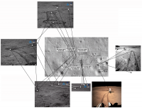
Several new images were tweeted by Andrew Jones. https://twitter.com/AJ_FI/status/1143769296973291521 Here I have reprojected them to make it easier for me to compare with a map, but so far I don't have good matches to locations for them. They suggest that the rover moved a bit to the west and then turned south during day 6 (so a map revision is needed), but I don't know enough to draw the route yet. The article linked by Andrew says (according to Google Translate) that there were control problems during day 6 caused - apparently - by a single bit flip error on a chip. The Mars rovers have seen these occasionally and recovered. They are caused by cosmic ray strikes. Yutu 2 has been recovered successfully.
EDIT: I replaced the middle image with a different version. The orientation is changed, but please bear in mind that these Hazcam images have a wider field of view than I show here. -------------------- ... because the Solar System ain't gonna map itself.
Also to be found posting similar content on https://mastodon.social/@PhilStooke Maps for download (free PD: https://upload.wikimedia.org/wikipedia/comm...Cartography.pdf NOTE: everything created by me which I post on UMSF is considered to be in the public domain (NOT CC, public domain) |
|||
|
|
|
|||
|
Jun 27 2019, 10:56 AM
Post
#231
|
|
|
Member Group: Members Posts: 156 Joined: 22-May 09 From: Ireland Member No.: 4792 |
When I first saw the left-most image, Phil, I immediately thought 'Oh, that doesn't look good - some kind of surface-gripping struggle going on there.' But then thought that perhaps the rover was just doing more than one pivot on its axis as it planned its next route.
Btw, the doughnut images are probably wrong, as while the date they appear publicly are always out by several earth days to weeks, the actual lunar day date that they were taken is tricky to pin down (of course, CLEP, has that data). John |
|
|
|
|
Jul 2 2019, 03:06 PM
Post
#232
|
|
|
Senior Member Group: Members Posts: 1074 Joined: 21-September 07 From: Québec, Canada Member No.: 3908 |
Two images of the lunar surface on the CNSA page.
|
|
|
|
|
Jul 9 2019, 07:29 PM
Post
#233
|
|||
|
Solar System Cartographer Group: Members Posts: 10151 Joined: 5-April 05 From: Canada Member No.: 227 |
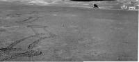
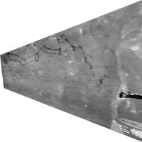
Andrew Jones tweets two new images:
https://twitter.com/AJ_FI/status/1148511189216956416 They can be fitted together to make a mini-panorama:
(here with some contrast enhancement). And that can be roughly reprojected to give a more map-like view:
The lighting is around noon, so the rover may have travelled further since they were taken. No details on the distance travelled yet. Phil -------------------- ... because the Solar System ain't gonna map itself.
Also to be found posting similar content on https://mastodon.social/@PhilStooke Maps for download (free PD: https://upload.wikimedia.org/wikipedia/comm...Cartography.pdf NOTE: everything created by me which I post on UMSF is considered to be in the public domain (NOT CC, public domain) |
||
|
|
|
||
|
Jul 9 2019, 08:24 PM
Post
#234
|
||
|
Solar System Cartographer Group: Members Posts: 10151 Joined: 5-April 05 From: Canada Member No.: 227 |
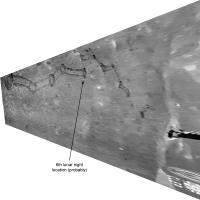
That last view with the 6th night location shown.
Phil
-------------------- ... because the Solar System ain't gonna map itself.
Also to be found posting similar content on https://mastodon.social/@PhilStooke Maps for download (free PD: https://upload.wikimedia.org/wikipedia/comm...Cartography.pdf NOTE: everything created by me which I post on UMSF is considered to be in the public domain (NOT CC, public domain) |
|
|
|
|
|
|
Jul 16 2019, 03:40 AM
Post
#235
|
|||
|
Solar System Cartographer Group: Members Posts: 10151 Joined: 5-April 05 From: Canada Member No.: 227 |
A new paper on topo mapping of the landing site:
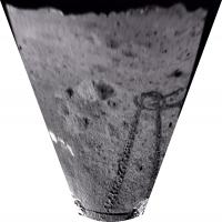
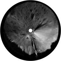
http://www.pmrslab.cn/publications/publica...3-1383-2019.pdf Here is a very small panorama from it (I have cleaned up some glare in it):
and a circular version for mapping:
These are from the end of lunar day 1. Phil -------------------- ... because the Solar System ain't gonna map itself.
Also to be found posting similar content on https://mastodon.social/@PhilStooke Maps for download (free PD: https://upload.wikimedia.org/wikipedia/comm...Cartography.pdf NOTE: everything created by me which I post on UMSF is considered to be in the public domain (NOT CC, public domain) |
||
|
|
|
||
|
Jul 27 2019, 05:33 AM
Post
#236
|
|||
|
Solar System Cartographer Group: Members Posts: 10151 Joined: 5-April 05 From: Canada Member No.: 227 |
This 'rover driving diary':
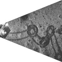
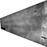
https://mp.weixin.qq.com/s/ULbPx6V957kW9CtR_cTU5g"" target="_blank">https://mp.weixin.qq.com/s/ULbPx6V957kW9CtR_cTU5g</a> has some new images in it from day 7. Andrew Jones had tweeted some of them. The impression I have is that the rover did not move very far after its lunch break in day 7, so the estimate in my last map was overly optimistic. The drive was 25 m in day 7. Here is a reprojected version of a mini-panorama from the link:
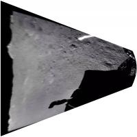
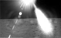
It is similar to the one I posted above but shows a little more progress, and the rover shadow at left shows it is taken with afternoon lighting. There are also two sun-struck images, which can be fitted together like this:
The view is to the northwest (showing the central peak) near sunset, presumably on day 7. Phil -------------------- ... because the Solar System ain't gonna map itself.
Also to be found posting similar content on https://mastodon.social/@PhilStooke Maps for download (free PD: https://upload.wikimedia.org/wikipedia/comm...Cartography.pdf NOTE: everything created by me which I post on UMSF is considered to be in the public domain (NOT CC, public domain) |
||
|
|
|
||
|
Jul 29 2019, 02:40 AM
Post
#237
|
|
|
Solar System Cartographer Group: Members Posts: 10151 Joined: 5-April 05 From: Canada Member No.: 227 |
Daniel Estevez has an analysis of the Longjiang 2 impact expected on 31 July:
https://destevez.net/2019/07/dslwp-b-mission-end-prediction/ It will crash near 15.5 north, 157.5 east, SE of Mare Moscoviense and about 300 km north of the Lunar Orbiter 1 impact site. Phil -------------------- ... because the Solar System ain't gonna map itself.
Also to be found posting similar content on https://mastodon.social/@PhilStooke Maps for download (free PD: https://upload.wikimedia.org/wikipedia/comm...Cartography.pdf NOTE: everything created by me which I post on UMSF is considered to be in the public domain (NOT CC, public domain) |
|
|
|
|
Jul 29 2019, 12:23 PM
Post
#238
|
|
|
Member Group: Members Posts: 156 Joined: 22-May 09 From: Ireland Member No.: 4792 |
Looks like somewhere northeast of Van Gent T.
John  |
|
|
|
|
Jul 31 2019, 05:26 PM
Post
#239
|
|
|
Senior Member Group: Members Posts: 1074 Joined: 21-September 07 From: Québec, Canada Member No.: 3908 |
Two images on the CNSA webpage, presumably taken on lunar day 8: http://www.cnsa.gov.cn/n6759533/c6807005/content.html
|
|
|
|
|
Jul 31 2019, 06:37 PM
Post
#240
|
|
 Senior Member Group: Members Posts: 1729 Joined: 3-August 06 From: 43° 35' 53" N 1° 26' 35" E Member No.: 1004 |
meanwhile, DSLWP-B has crashed on the moon, as expected
https://twitter.com/cgbassa/status/1156575266153648128 QUOTE There is a new crater on the Moon... We are already 5 minutes past the moment DSLWP-B would've appeared from behind the Moon if it had not crashed. The fact that we are no longer receiving signals means it has impacted the lunar surface. RIP DSLWP-B.
|
|
|
|
|

|
Lo-Fi Version | Time is now: 24th April 2024 - 11:52 PM |
|
RULES AND GUIDELINES Please read the Forum Rules and Guidelines before posting. IMAGE COPYRIGHT |
OPINIONS AND MODERATION Opinions expressed on UnmannedSpaceflight.com are those of the individual posters and do not necessarily reflect the opinions of UnmannedSpaceflight.com or The Planetary Society. The all-volunteer UnmannedSpaceflight.com moderation team is wholly independent of The Planetary Society. The Planetary Society has no influence over decisions made by the UnmannedSpaceflight.com moderators. |
SUPPORT THE FORUM Unmannedspaceflight.com is funded by the Planetary Society. Please consider supporting our work and many other projects by donating to the Society or becoming a member. |
|