How can I remove banding effect from .cub file Magellan Venus |

How can I remove banding effect from .cub file Magellan Venus |
 Feb 2 2016, 07:58 AM Feb 2 2016, 07:58 AM
Post
#1
|
||
|
Junior Member  Group: Members Posts: 91 Joined: 21-August 06 Member No.: 1063 |
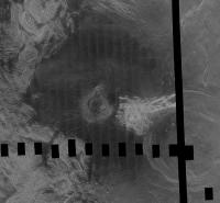
I have this .cub file of a section of Venus taken by Magellan that I got from map-a-planet2. Picture included below. You can see the striping effect. Does anyone know of a way to remove this banding effect easily in ISIS3 or another tool?
The best answer I have to far is using "Equalizer" in ISIS3 https://isis.astrogeology.usgs.gov/Applicat.../equalizer.html Problem though is it looks like you have to fix it using the original striped input images before they are assembled into a .cub. All I have though is the .cub that was already mosaicked. Any suggestions on how to remove the striped effect at this point? I dont believe those orginal individual striped images are avaible to public. All I know of is the 130 gb .cub file found on mapaplanet2 from which this image was taken from. thanks
Attached thumbnail(s)
|
|
 |
 
|
|
 |
|
Feb 4 2016, 12:48 AM
Post
#2
|
|
|
Member Group: Members Posts: 890 Joined: 18-November 08 Member No.: 4489 |
my large map is here:
-- do to age the below links do not work if someone needs it PM me https://drive.google.com/file/d/0B6ZYAd08tZ...iew?usp=sharing and https://drive.google.com/open?id=0B6ZYAd08t...SXpvS1V1T3R5bDg this 4.91 gig zip ( would be smaller if i used xz archive) unzips to a 8 gig , 1 band isis3 cub file 131072 x 65536 pixels this is the header CODE Object = IsisCube
Object = Core StartByte = 65537 Format = Tile TileSamples = 2048 TileLines = 2048 Group = Dimensions Samples = 131072 Lines = 65536 Bands = 1 End_Group Group = Pixels Type = UnsignedByte ByteOrder = Lsb Base = 0.0 Multiplier = 1.0 End_Group End_Object Group = Mapping ProjectionName = SimpleCylindrical CenterLongitude = 0.0 <degrees> TargetName = Venus EquatorialRadius = 1737400.0 <meters> PolarRadius = 1737400.0 <meters> LatitudeType = Planetocentric LongitudeDirection = PositiveEast LongitudeDomain = 180 <degrees> MinimumLatitude = -90.0 <degrees> MaximumLatitude = 90.0 <degrees> MinimumLongitude = -180.0 <degrees> MaximumLongitude = 180.0 <degrees> UpperLeftCornerX = -5458203.0763469 <meters> UpperLeftCornerY = 2729101.5381735 <meters> PixelResolution = 83.285569402241 <meters> # PixelResolution = <meters/pixel> Scale = 364.088888889 <pixels/degree> End_Group End_Object Object = Label Bytes = 65536 End_Object Object = History Name = IsisCube StartByte = 8590000129 Bytes = 1748 End_Object End |
|
|
|
 ncc1701d How can I remove banding effect from .cub file Magellan Venus Feb 2 2016, 07:58 AM
 Bjorn Jonsson dstripe in ISIS3 can remove striping but the probl... Feb 2 2016, 12:16 PM mcaplinger QUOTE (ncc1701d @ Feb 1 2016, 11:58 PM) I... Feb 2 2016, 02:53 PM JohnVV if you want i just gave a copy of my 131072x65536 ... Feb 3 2016, 03:08 AM JohnVV an example from the C1
http://pds-imaging.jpl.nasa... Feb 3 2016, 04:07 AM Ian R That's amazing, John. Somewhat on a tangent, c... Feb 3 2016, 05:38 AM JohnVV ian
for that cub ?? no
if you work with each o... Feb 3 2016, 06:38 AM mcaplinger Given how well this worked, I'm surprised no o... Feb 3 2016, 08:05 PM JohnVV mcaplinger
that IS my map on the Celestia mother... Feb 3 2016, 08:49 PM
Bjorn Jonsson dstripe in ISIS3 can remove striping but the probl... Feb 2 2016, 12:16 PM mcaplinger QUOTE (ncc1701d @ Feb 1 2016, 11:58 PM) I... Feb 2 2016, 02:53 PM JohnVV if you want i just gave a copy of my 131072x65536 ... Feb 3 2016, 03:08 AM JohnVV an example from the C1
http://pds-imaging.jpl.nasa... Feb 3 2016, 04:07 AM Ian R That's amazing, John. Somewhat on a tangent, c... Feb 3 2016, 05:38 AM JohnVV ian
for that cub ?? no
if you work with each o... Feb 3 2016, 06:38 AM mcaplinger Given how well this worked, I'm surprised no o... Feb 3 2016, 08:05 PM JohnVV mcaplinger
that IS my map on the Celestia mother... Feb 3 2016, 08:49 PM
 mcaplinger QUOTE (JohnVV @ Feb 3 2016, 12:49 PM) in ... Feb 3 2016, 10:27 PM
 |

|
Lo-Fi Version | Time is now: 6th June 2024 - 03:06 AM |
|
RULES AND GUIDELINES Please read the Forum Rules and Guidelines before posting. IMAGE COPYRIGHT |
OPINIONS AND MODERATION Opinions expressed on UnmannedSpaceflight.com are those of the individual posters and do not necessarily reflect the opinions of UnmannedSpaceflight.com or The Planetary Society. The all-volunteer UnmannedSpaceflight.com moderation team is wholly independent of The Planetary Society. The Planetary Society has no influence over decisions made by the UnmannedSpaceflight.com moderators. |
SUPPORT THE FORUM Unmannedspaceflight.com is funded by the Planetary Society. Please consider supporting our work and many other projects by donating to the Society or becoming a member. |
|