The Top of Vera Rubin Ridge Part 1, Site 66-67, sol 1812-1943, 11 Sep 2017-23 Jan 2018 |

  |
The Top of Vera Rubin Ridge Part 1, Site 66-67, sol 1812-1943, 11 Sep 2017-23 Jan 2018 |
 Nov 12 2017, 11:31 AM Nov 12 2017, 11:31 AM
Post
#136
|
|||
 Senior Member  Group: Members Posts: 2425 Joined: 30-January 13 From: Penang, Malaysia. Member No.: 6853 |
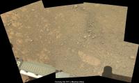
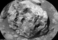
Curiosity's weekend workspace L-MastCam, raw in MS ICE. Also a rather nice cropped ChemCam RMI target that features in the workspace. sadly no target names (yet)
|
||
 |
 
|
||
|
Nov 12 2017, 02:03 PM
Post
#137
|
|
 Senior Member Group: Members Posts: 1619 Joined: 12-February 06 From: Bergerac - FR Member No.: 678 |
Hi everyone
 Found some motivation to do some work there. So, a little bunch of panoramic of my own Sol 1866 Mastcam34  Sol 1867 Navcam  Sol 1869 Navcam  Sol 1871 Navcam  And an extra postcard, from Sol 1866, by Mastcam100 :  Enjoy
-------------------- |
|
|
|
|
Nov 12 2017, 05:13 PM
Post
#138
|
|
|
Senior Member Group: Members Posts: 2919 Joined: 14-February 06 From: Very close to the Pyrénées Mountains (France) Member No.: 682 |
C'est la cas!
Merci Damia -------------------- |
|
|
|
|
Nov 12 2017, 10:31 PM
Post
#139
|
||
|
Senior Member Group: Members Posts: 2819 Joined: 22-April 05 From: Ridderkerk, Netherlands Member No.: 353 |
The Navcam L view on Sol 1873.
Jan van Driel
|
|
|
|
|
|
|
Nov 12 2017, 10:34 PM
Post
#140
|
||
|
Senior Member Group: Members Posts: 2425 Joined: 30-January 13 From: Penang, Malaysia. Member No.: 6853 |
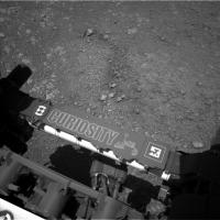
Possible aborted drive on 1873, very small move, nothing obvious in the workspace that would warrant a short bump, but what do I know
|
|
|
|
|
|
|
Nov 13 2017, 12:25 AM
Post
#141
|
|
|
Senior Member Group: Members Posts: 1619 Joined: 12-February 06 From: Bergerac - FR Member No.: 678 |
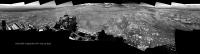
Sol 1873 Navcam panoramic :
-------------------- |
|
|
|
|
Nov 13 2017, 01:32 AM
Post
#142
|
|
 Member Group: Members Posts: 684 Joined: 24-July 15 Member No.: 7619 |
QUOTE (Phil Stooke @ Nov 11 2017, 10:25 PM)  QUOTE (HSchirmer) "But, if you don't drill actual bedrock, how would you know it's the same geologic unit?" All the ChemCam and APXS data, plus geological interpretation of HiRISE and rover images. ... Phil Good point. But, eh, I guess I should have phrased my question differently.... What if Vera Ruben Ridge was influenced by groundwater from a deep fault https://www.lpi.usra.edu/meetings/lpsc2013/pdf/3106.pdf  would we be able to identify vertical displacement? Lots of sedimentary basins on Earth have developed deep faults that create paths for groundwater flow-  Would there any way to determine whether the geological unit NORTH of the Vera Rubin Ridge has moved higher or lower than the same geological unit SOUTH of Vera Rubin Ridge? |
|
|
|
|
Nov 13 2017, 02:59 AM
Post
#143
|
|
|
Solar System Cartographer Group: Members Posts: 10149 Joined: 5-April 05 From: Canada Member No.: 227 |
So the first step would need to be detailed geological mapping using HiRISE images and the CRISM compositional data. Is there much evidence of faulting? Not sure, but it could be looked for. My impression is that there has not been a huge amount of faulting, so I would not be expecting an explanation based on large vertical motions. But I haven't done that work myself. Part of the reason for all the Mastcam imaging of the ridge along its northern side was to map the stratigraphy and structure. That can continue to the south as well. Wil there be evidence of vertical offsets? Or is it all stratigraphy, layer after layer without much faulting? I don't know, but that's how it could be tackled.
Phil -------------------- ... because the Solar System ain't gonna map itself.
Also to be found posting similar content on https://mastodon.social/@PhilStooke NOTE: everything created by me which I post on UMSF is considered to be in the public domain (NOT CC, public domain) |
|
|
|
|
Nov 13 2017, 03:35 AM
Post
#144
|
|
|
Member Group: Members Posts: 684 Joined: 24-July 15 Member No.: 7619 |
QUOTE (Phil Stooke @ Nov 13 2017, 03:59 AM) So the first step would need to be detailed geological mapping using HiRISE images and the CRISM com positional data. Is there much evidence of faulting? Not sure, but it could be looked for. My impression is that there has not been a huge amount of faulting, so I would not be expecting an explanation based on large vertical motions. But I haven't done that work myself. Part of the reason for all the Mastcam imaging of the ridge along its northern side was to map the stratigraphy and structure. That can continue to the south as well. Will there be evidence of vertical offsets? Or is it all stratigraphy, layer after layer without much faulting? I don't know, but that's how it could be tackled. Phil Well, reason I'm asking, what may be dumb questions. Given the amount of boxwork exposed not that far away- at Naukluft plateau, and at the base of Mount Sharp  and given estimates that boxwork features are likely due to groundwater, and given estimates that cubic kilometers of groundwater are needed to create the boxwork features https://thesis.library.caltech.edu/9838/1/S...chapters1-3.pdf Then it might be interesting to look at layering, not just "It's sandstone" or "it's mudstone" but which lake layer are we talking about? Idea being, that identification of specific lake layers, allows you to identify offset faults, and identify discontinuities. Now, that's a HUGE challenge to put on somebody else, doing high resolution stratigraphapy takes huge amounts of data. I'm just a bit curious whether the huge amounts of data being collected could eventually identify likely groundwater sources.- "oh, there's a fault here, we see that the layers are offset by (1, 10, 100, 1000 meters) which suggests that there's a connection to groundwater going down at least (1, 10, 100, 1000 meters)... |
|
|
|
|
Nov 13 2017, 02:58 PM
Post
#145
|
|
|
Member Group: Admin Posts: 976 Joined: 29-September 06 From: Pasadena, CA - USA Member No.: 1200 |
QUOTE (PaulH51 @ Nov 12 2017, 02:34 PM) Possible aborted drive on 1873, very small move, nothing obvious in the workspace that would warrant a short bump, but what do I know The drive was intentionally short. Some targets were out of reach and on the previous drive we did not want to overshoot. While our cameras are well calibrated one has to account for some measurement errors! Paolo -------------------- Disclaimer: all opinions, ideas and information included here are my own,and should not be intended to represent opinion or policy of my employer.
|
|
|
|
|
Nov 13 2017, 08:00 PM
Post
#146
|
|
|
Senior Member Group: Members Posts: 2425 Joined: 30-January 13 From: Penang, Malaysia. Member No.: 6853 |
QUOTE (RoverDriver @ Nov 13 2017, 10:58 PM) The drive was intentionally short. Some targets were out of reach and on the previous drive we did not want to overshoot. While our cameras are well calibrated one has to account for some measurement errors! Many thanks Paolo, also the weekend plan just got released and it mentioned the 'bump'
|
|
|
|
|
Nov 13 2017, 08:19 PM
Post
#147
|
|
|
Senior Member Group: Members Posts: 1074 Joined: 21-September 07 From: Québec, Canada Member No.: 3908 |
Sol 1873 Lmastcam:
|
|
|
|
|
Nov 13 2017, 11:08 PM
Post
#148
|
|
|
Member Group: Admin Posts: 976 Joined: 29-September 06 From: Pasadena, CA - USA Member No.: 1200 |
QUOTE (PaulH51 @ Nov 13 2017, 12:00 PM) Many thanks Paolo, also the weekend plan just got released and it mentioned the 'bump' One would think there's a uniform understanding of what constitutes as a "bump". I have seen a 20-30m drive referred to as a bump. I end up calling anything that is less than a meter a "burp" since that typically requires only one or two rover steps. Paolo -------------------- Disclaimer: all opinions, ideas and information included here are my own,and should not be intended to represent opinion or policy of my employer.
|
|
|
|
|
Nov 14 2017, 01:37 PM
Post
#149
|
|
|
Senior Member Group: Members Posts: 2346 Joined: 7-December 12 Member No.: 6780 |
QUOTE (HSchirmer @ Nov 13 2017, 05:35 AM) ...and given estimates that boxwork features are likely due to groundwater ... Tafoni and honeycomb weathering as examples of salt weathering are other options, Given the sulfate-rich overlying layers, I'd consider some kind of salt weathering as another, if not more plausible, cause of the boxwork. This doesn't rule out additional groundwater activity, but it may be less evident, at least from a distance. |
|
|
|
|
Nov 14 2017, 09:15 PM
Post
#150
|
|
|
Senior Member Group: Members Posts: 1043 Joined: 17-February 09 Member No.: 4605 |
The boxwork is on the horizon between the sulphate rich upper member of the Mount Sharp lower formation and the overlying aeolian deposits. There would almost certainly have been a hiatus following the final water influenced deposition so dessication fracturing must be a contender and given the lack of lithification of the overlying deposits any subsequent groundwater interaction must have occurred before the aeolian deposition.
|
|
|
|
|

|
Lo-Fi Version | Time is now: 23rd April 2024 - 06:41 AM |
|
RULES AND GUIDELINES Please read the Forum Rules and Guidelines before posting. IMAGE COPYRIGHT |
OPINIONS AND MODERATION Opinions expressed on UnmannedSpaceflight.com are those of the individual posters and do not necessarily reflect the opinions of UnmannedSpaceflight.com or The Planetary Society. The all-volunteer UnmannedSpaceflight.com moderation team is wholly independent of The Planetary Society. The Planetary Society has no influence over decisions made by the UnmannedSpaceflight.com moderators. |
SUPPORT THE FORUM Unmannedspaceflight.com is funded by the Planetary Society. Please consider supporting our work and many other projects by donating to the Society or becoming a member. |
|