The Top of Vera Rubin Ridge Part 1, Site 66-67, sol 1812-1943, 11 Sep 2017-23 Jan 2018 |

  |
The Top of Vera Rubin Ridge Part 1, Site 66-67, sol 1812-1943, 11 Sep 2017-23 Jan 2018 |
 Nov 29 2017, 07:06 AM Nov 29 2017, 07:06 AM
Post
#181
|
||
 Senior Member  Group: Members Posts: 2428 Joined: 30-January 13 From: Penang, Malaysia. Member No.: 6853 |
It's a pity they don't do the cloud and DD searches with the stereo paired cameras.
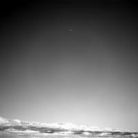
An 1888 R-NavCam sequence of 8 frames has a really nice cosmic ray strike or whatever else one would like to think it is  The version uploaded here is increased in size to 1000x1000 and a link provided to the raw image (511x511)
A stereo pair would have been nice to prove one way or another that it's unlikely to be an incoming space rock or a piece of space junk etc but a simple cosmic ray strike with a nice tail
|
|
 |
 
|
|
|
Nov 29 2017, 11:49 AM
Post
#182
|
|
|
Senior Member Group: Members Posts: 1074 Joined: 21-September 07 From: Québec, Canada Member No.: 3908 |
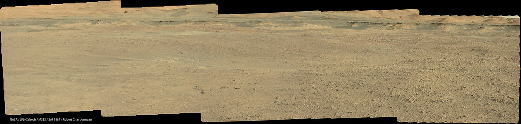
The sol 1887 Lmastcam view:
|
|
|
|
|
Nov 29 2017, 07:08 PM
Post
#183
|
|
|
Founder Group: Chairman Posts: 14432 Joined: 8-February 04 Member No.: 1 |
QUOTE (PaulH51 @ Nov 28 2017, 11:06 PM)  It's a pity they don't do the cloud and DD searches with the stereo paired cameras. So - apart from doubling the data volume* for observations like this - there's another problem. The PRT used to monitor the Navcams is on the right camera. Just under a year ago - we had an instance where we were taking dust devil and cloud movies, early in the morning, with the left camera - under the assumption that the heating being used that put the right camera into the allowable flight temperature range ( -55degC ) meant the left camera was in that safe range as well. On a few occasions due to lighting conditions, rover orientation etc...it wasn't. The left camera was used The result is - we now have a thing called the no-heat-window - a period of time when it's OK to use both Navcams because the thermal team are confident that they'll be warm enough to be used anyway. Inside that window - we can do stereo. OUTside that window ( and it's typically around 1100 to 1800 at this time of year ) we're not allowed to use the left camera at all. So - while ENV (environmental stuff - clouds, dust devils, etc etc) observations get done all over the place - the really nice early morning ones couldn't be done in stereo anyway because of this thermal constraint. If you're wondering when this all happened - find the time when those observations swapped over from the left navcam to the right navcam ( shortly after Sol 1602 I think ) * There are some tricks one could maybe use in terms of issuing a data re-prioritization ...but that would be a BIIIGgg data management headache) |
|
|
|
|
Nov 29 2017, 09:53 PM
Post
#184
|
|
 Administrator Group: Admin Posts: 5172 Joined: 4-August 05 From: Pasadena, CA, USA, Earth Member No.: 454 |
Gosh darn it this should be in my book and it's too late.
-------------------- My website - My Patreon - @elakdawalla on Twitter - Please support unmannedspaceflight.com by donating here.
|
|
|
|
|
Nov 29 2017, 11:15 PM
Post
#185
|
|
|
Senior Member Group: Members Posts: 2346 Joined: 7-December 12 Member No.: 6780 |
QUOTE (PaulH51 @ Nov 29 2017, 08:06 AM) A stereo pair would have been nice to prove one way or another that it's unlikely to be an incoming space rock or a piece of space junk etc but a simple cosmic ray strike with a nice tail A possible impact site would be almost on a straight line defined by the intersection of the plane of the possible paths of a presumed meteorite with the martian surface. So it might be, that it would show up as one ore more darkish spots on a future HiRISE image, if it isn't too far away from Curiosity's location. At least something to check for. |
|
|
|
|
Nov 30 2017, 05:46 AM
Post
#186
|
|
|
Senior Member Group: Members Posts: 2428 Joined: 30-January 13 From: Penang, Malaysia. Member No.: 6853 |
QUOTE (djellison @ Nov 30 2017, 03:08 AM) So - apart from doubling the data volume.... Many thanks to Doug for the very valuable insight Also Gerald for the suggestion to keep an eye on future HiRISE image around Gale for fresh impacts
|
|
|
|
|
Nov 30 2017, 07:49 AM
Post
#187
|
||
|
Senior Member Group: Members Posts: 2428 Joined: 30-January 13 From: Penang, Malaysia. Member No.: 6853 |
Another long-distance telescopic survey with ChemCam, this time on sol 1890 featuring 'a fan like deposit closer to Mt. Sharp' (mentioned in this mission update)
All ten frames were roughly assembled using MS ICE without additional processing. Raw images Link
|
|
|
|
|
|
|
Nov 30 2017, 12:14 PM
Post
#188
|
|
 Senior Member Group: Members Posts: 1619 Joined: 12-February 06 From: Bergerac - FR Member No.: 678 |
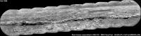
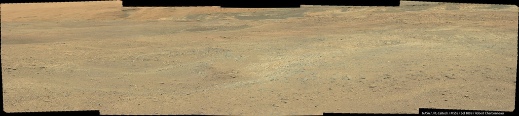
Sol 1889 Navcam panoramic
-------------------- |
|
|
|
|
Nov 30 2017, 01:36 PM
Post
#189
|
|
|
Senior Member Group: Members Posts: 2428 Joined: 30-January 13 From: Penang, Malaysia. Member No.: 6853 |
QUOTE (Ant103 @ Nov 30 2017, 08:14 PM) Sol 1889 Navcam panoramic Nice... The inner rim wall looks much better with these lower levels of atmospheric dust |
|
|
|
|
Nov 30 2017, 06:48 PM
Post
#190
|
||
|
Solar System Cartographer Group: Members Posts: 10151 Joined: 5-April 05 From: Canada Member No.: 227 |
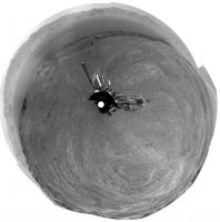
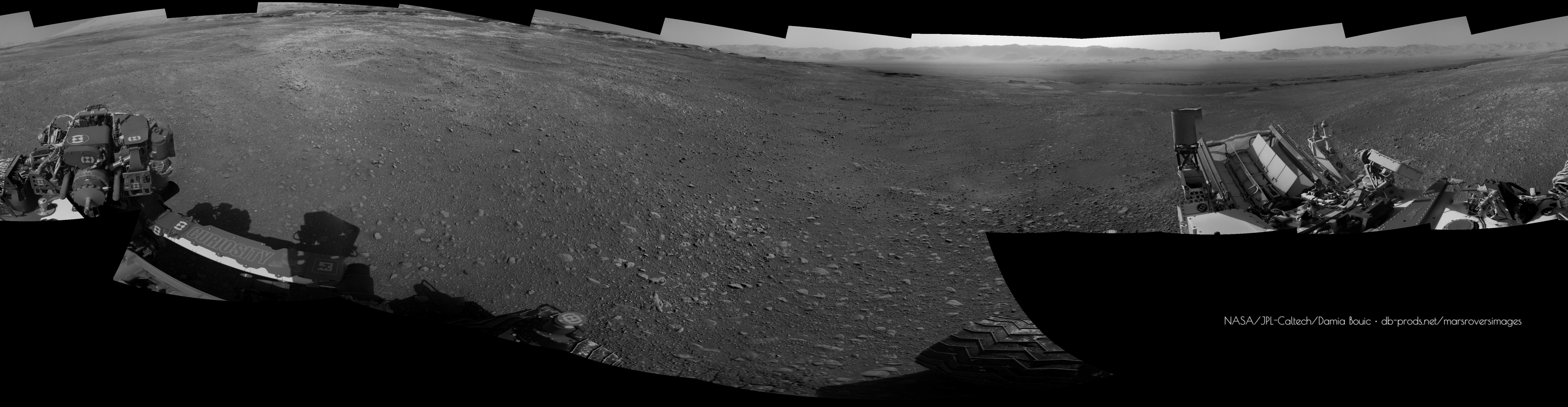
Damia's latest panorama in circular form. Thanks!
Phil
-------------------- ... because the Solar System ain't gonna map itself.
Also to be found posting similar content on https://mastodon.social/@PhilStooke Maps for download (free PD: https://upload.wikimedia.org/wikipedia/comm...Cartography.pdf NOTE: everything created by me which I post on UMSF is considered to be in the public domain (NOT CC, public domain) |
|
|
|
|
|
|
Nov 30 2017, 10:17 PM
Post
#191
|
|
|
Senior Member Group: Members Posts: 1074 Joined: 21-September 07 From: Québec, Canada Member No.: 3908 |
The sol 1889 Lmastcam drive direction view:
|
|
|
|
|
Dec 1 2017, 01:26 AM
Post
#192
|
|
|
Senior Member Group: Members Posts: 2428 Joined: 30-January 13 From: Penang, Malaysia. Member No.: 6853 |
The planned drive for sol 1891 towards the Southeast may take the rover close to the next map quadrant. Any guesses on the theme for the next quadrant?
|
|
|
|
|
Dec 4 2017, 08:44 AM
Post
#193
|
||
|
Senior Member Group: Members Posts: 2428 Joined: 30-January 13 From: Penang, Malaysia. Member No.: 6853 |
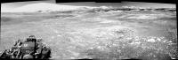
Just 4 of the L-NavCams after the drive on Sol 1894, the rest of the images are down, but MS ICE did not want to play ball today. However, these may help to narrow down the location until someone can stitch the set together
Nice to see the whole of the mountain without the need for a top tier, great pointing JPL Looking forward to seeing the full pan
|
|
|
|
|
|
|
Dec 4 2017, 12:25 PM
Post
#194
|
|
|
Senior Member Group: Members Posts: 1619 Joined: 12-February 06 From: Bergerac - FR Member No.: 678 |
This panorama taken on Sol 1894 is just incredible. Like we could touch the hills !

-------------------- |
|
|
|
|
Dec 4 2017, 09:16 PM
Post
#195
|
|
 Member Group: Members Posts: 809 Joined: 3-June 04 From: Brittany, France Member No.: 79 |
Nice work Damia! What a wonderful sight
 Let's Let's  to the hills! to the hills!
-------------------- |
|
|
|
|

|
Lo-Fi Version | Time is now: 25th April 2024 - 10:47 AM |
|
RULES AND GUIDELINES Please read the Forum Rules and Guidelines before posting. IMAGE COPYRIGHT |
OPINIONS AND MODERATION Opinions expressed on UnmannedSpaceflight.com are those of the individual posters and do not necessarily reflect the opinions of UnmannedSpaceflight.com or The Planetary Society. The all-volunteer UnmannedSpaceflight.com moderation team is wholly independent of The Planetary Society. The Planetary Society has no influence over decisions made by the UnmannedSpaceflight.com moderators. |
SUPPORT THE FORUM Unmannedspaceflight.com is funded by the Planetary Society. Please consider supporting our work and many other projects by donating to the Society or becoming a member. |
|