

Ingenuity- Mars 2020 Helicopter, Deployment & Operations |

  |
Ingenuity- Mars 2020 Helicopter, Deployment & Operations |
 Dec 15 2021, 07:44 PM Dec 15 2021, 07:44 PM
Post
#556
|
||
|
Junior Member  Group: Members Posts: 91 Joined: 11-August 21 Member No.: 9072 |
QUOTE (tau @ Dec 15 2021, 06:48 PM)  Bras hill is marked with B in the image below. Thank you, Tau. Maybe I misunderstand this statement QUOTE When we originally planned Flight 17, we believed that the rover was going to be parked in a specific location and oriented in a certain direction. However, Perseverances plans change day to day to maximize overall science return. https://mars.nasa.gov/technology/helicopter/status/350 but given these elevations, where nothing changed significantly from sol 281 to sol 282, neither the elevation, not the azimuth to the planned landing site. 280 -2572,029541 281 -2574,433838 282 (flight date) 283 -2574,299316 it comes out that the Ingenuity team beleived that Perseverance still stands where it stood on sol 280, or 2 days before the planned departure date? I'm sorry again if I misunderstood something in the complaint that 'Perseverances plans change day to day'
Attached thumbnail(s)
|
|
 |
 
|
|
|
Dec 15 2021, 10:50 PM
Post
#557
|
|
|
Solar System Cartographer Group: Members Posts: 10226 Joined: 5-April 05 From: Canada Member No.: 227 |
"When we originally planned Flight 17, we believed that the rover was going to be parked in a specific location and oriented in a certain direction. "
The rover turned in place, so the location and elevation did not change, but the new orientation was not so suitable for communication with the helicopter. Phil -------------------- ... because the Solar System ain't gonna map itself.
Also to be found posting similar content on https://mastodon.social/@PhilStooke Maps for download (free PDF: https://upload.wikimedia.org/wikipedia/comm...Cartography.pdf NOTE: everything created by me which I post on UMSF is considered to be in the public domain (NOT CC, public domain) |
|
|
|
|
Dec 15 2021, 10:56 PM
Post
#558
|
|
 Senior Member Group: Members Posts: 2431 Joined: 30-January 13 From: Penang, Malaysia. Member No.: 6853 |
Extract from this press release : https://www.jpl.nasa.gov/news/nasas-ingenui...0-minutes-aloft
QUOTE Flight 18 is scheduled to take place no earlier than today, Dec. 15, with Ingenuity covering another 754 feet (230 meters) at a speed of 5.6 mph (2.5 meters per second) over 125 seconds. The new airfield, close to the northern boundary of Séítah, will be the rotorcrafts 10th on Mars. Data from the flight is expected to be received at JPL no earlier than in the late afternoon today. As with the previous effort, Flight 18 will push the limits of Ingenuitys radio range and performance. To provide it with the best chance of maintaining a link throughout landing, the Mars Helicopter team has modified the flight sequence to communicate in a low-data-rate mode, which will provide an additional signal-strength boost to the radio link. If we do lose radio link on landing, it may be several days or weeks until the line-of-sight between Ingenuity and Perseverance improves enough to attempt a communication session, said Tzanetos. While delaying our post-flight data analysis is an inconvenience, it is not unexpected and becoming the new normal as we continue to operate in challenging terrain in the weeks ahead. |
|
|
|
|
Dec 16 2021, 07:18 AM
Post
#559
|
||
|
Senior Member Group: Members Posts: 2431 Joined: 30-January 13 From: Penang, Malaysia. Member No.: 6853 |
Looks like flight 18 completed successfully, here's one of 5 Navcam's that show the last moments of the flight, the JSON data has not been issued yet, but I believe the point to point distance was ~230 meters (as planned) but it appears to have landed inside a trough of a sand ripple inside North Seitah. The landing site was captured during flight 9 by one of the RTE images. James Sorenson created this animation that identifies the landing site link
|
|
|
|
|
|
|
Dec 16 2021, 09:40 AM
Post
#560
|
|
|
Junior Member Group: Members Posts: 91 Joined: 11-August 21 Member No.: 9072 |
QUOTE (PaulH51 @ Dec 16 2021, 10:18 AM) James Sorenson created this animation that identifies the landing site link Nice, but too short  . .I had a use of compiling the animations for almost all the flights: they are kept in this catalogue at the Wikimedia Commons storage. However my principle was not to rush with the assembly until the whole 180/190 frame set appears at NASA's storage. Rotation ground tests were the only exclusion. However, no additional frames (to 5 existing) appeared after flight 17, and I still wait for the missing frames, doing nothing. Although manual display time setting for each of 200 frames is a time consuming process, I wrote a simple code to extract seconds and millis from file names thereby bringing the scrolling of frames closer to a real-time documentary film. Today I fear I shall not have the occasion for this enhancement, because 5 frames is too short time. |
|
|
|
|
Jan 5 2022, 05:46 PM
Post
#561
|
|
|
Senior Member Group: Members Posts: 2106 Joined: 13-February 10 From: Ontario Member No.: 5221 |
New year, new flight planned for Friday. https://mars.nasa.gov/technology/helicopter...same-ingenuity/
This caught my eye: QUOTE The final act of the flight is to turn nearly 180 degrees to flip the RTE camera to a forward-facing orientation for future flights toward the river delta. Trying to parse this; are they leaving Perseverance behind already!? |
|
|
|
|
Jan 5 2022, 07:21 PM
Post
#562
|
|
|
Member Group: Members Posts: 715 Joined: 22-April 05 Member No.: 351 |
QUOTE (Explorer1 @ Jan 5 2022, 09:46 AM) New year, new flight planned for Friday. https://mars.nasa.gov/technology/helicopter...same-ingenuity/ This caught my eye: Trying to parse this; are they leaving Perseverance behind already!? Nope. They want to have Ingenuity available when Perseverance arrives at the Delta. But Ingenuity might be able go directly over some terrain that Perseverance will have to take the long way around. -------------------- |
|
|
|
|
Jan 6 2022, 12:56 AM
Post
#563
|
|
|
Senior Member Group: Members Posts: 2106 Joined: 13-February 10 From: Ontario Member No.: 5221 |
How will they communicate at such a distance though? We saw the problems even a little bit of topography between Ingenuity and Perseverance can cause.
|
|
|
|
|
Jan 6 2022, 02:32 AM
Post
#564
|
|
|
Senior Member Group: Members Posts: 1057 Joined: 17-February 09 Member No.: 4605 |
The maximum communication range is 1,000 metres, with maximum range for a flight probably half that given the extra power required to fly in the current, declining atmospheric density. I would assume that the flight profiles will be designed to ensure that Ingenuity is always in data contact with Perseverance and hence Earth based taskers. The performance of what was a concept demonstrator has been surprising.
|
|
|
|
|
Jan 23 2022, 01:29 AM
Post
#565
|
|
|
Junior Member Group: Members Posts: 91 Joined: 11-August 21 Member No.: 9072 |
Before flight 19 (hopefully) starts today, I ask the permission to put forward a series of questions I accumulated upon the photos that trace the ground activities of Ingenuity after flight 18.
Sol 292, December 15. Flight 18 landing.  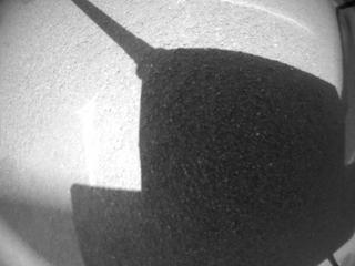 (left) 12:04:35 before touch-down; (right) 12:04:36 touch-down Question. Presuming the helicopter always lands vertically, may the visible difference of space between the legs and the ground surface be used in calculations of the slope angle? (In this case helicopters' body is expected to have the backwards tilt after the final touch-down) Sol 297, December 20. Three from the series of 4 NAV photos 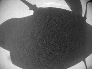  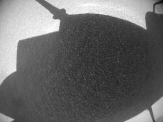 DTG, left to right 11:10:44, 11:12:27, [skipped], 11:16:47 Skipped photo is timestamped 11:14:37, URL is here Note the light arcuate streak on the ground, going parallel to the upper (front) edge of the helicopter's body shadow. On January 9-10 it shall 'disappear' from the NAV photos. Question. A slow-speed rotation test on sol 297, isn't it? |
|
|
|
|
Jan 23 2022, 01:33 AM
Post
#566
|
|
|
Junior Member Group: Members Posts: 91 Joined: 11-August 21 Member No.: 9072 |
Sol 302, December 26, 12:37:28. Color photo from RTE.
Left: Sol 302, December 26, 12:37:28; Right: Sol 045, April 6, 13:58:38 (Wright Brothers' Field)   URL of the heavy full-size 27 Mb image is here Comment (am I right?): a piece of sky confirms my hypothesis about the backwards tilt; the absence of sky in the left corner adds that the left pair of Ingenuity's legs stands topographically lower thus providing a CCW inclination. The airborne RTE photos (not shown here) always display the inner edges of the 'hoofs' for both Ingenuity's legs. Instead of 'hoofs', available ground photos (here the one for sol 45 is shown for comparison purposes) display the middle part of only one front leg (or its shadow) instead of both. The reason for that may be the gravity which spreads the legs wider under the weight of the helicopter. Taking the Wright Brothers' Field as a close-to-ideal flat surface étalon we may draw the conclusion that the surface of Airfield L for today's (Jan. 23) start has the backward and 'left' inclination. Possibility: panorama gurus may calculate the azimuth for this photo. Sols 316 and 317, January 9 and 10, LMST 11:01:22 and 11:00:49 respectively. 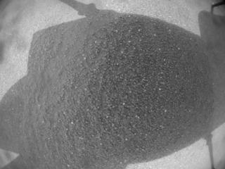  Comment (am I right?): the paleness of NAV images shot 2-3 sols after the cancelled flight on January 7 may be caused by worsening tau. Remember the light arcuate streak on the ground we saw on December 20? Now it 'disappears' either because of sandy mist or being covered with the dust brought by the wind. Instead, we see a group of new blobs in the top left corner. They repeat on photo(s) taken on January 13. Are they the new ground features brought/uncovered with the wind, or they reside on the NAV optics shall be clear after flight 19. Question. To what extent may the decrease of visibility (tau) affect the capabilities of the NAV-based inertial navigation? |
|
|
|
|
Jan 23 2022, 01:39 AM
Post
#567
|
|
|
Junior Member Group: Members Posts: 91 Joined: 11-August 21 Member No.: 9072 |
Sol 320, January 13.
i) Camera NAV, timestamp 11:01:17 LMST.  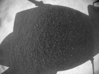 Apparently a duplicate stored under different file names. Note that the difference involves only the 4-digit group corresponding to the sol number while the DTG group (seconds_milliseconds) is exactly the same. HNM_0320_0695342787_991ECM_N0180001HELI00141_0000A0J01 HNM_0302_0695342787_991ECM_N0180001HELI00141_0000A0J01 Question. Lost time stamp, manual database record editing, ...? Position of blades is the same, as on sols 316-317. ii) Camera RTE, timestamp 11:01:38 LMST.   Unlike the previous pair of NAV images, this pair from RTE are actually different, taken in the 16 ms interval within the same second. However there's the same mess with the filenames HSF_0302_0695342810_000ECM_N0180001HELI00000_000085J HSF_0320_0695342810_016ECM_N0180001HELI00000_000085J File names were already different 000 (milliseconds) for the earliest versus 016 (milliseconds) for the latest, so what could be the reason for changing the sol group from 320 to 302? Question. The blades are in the 'rabbit's ears' position now. Another blade rotation test between 11:01:17 and 11:01:38? |
|
|
|
|
Jan 23 2022, 08:17 PM
Post
#568
|
|
|
Senior Member Group: Members Posts: 3008 Joined: 30-October 04 Member No.: 105 |
QUOTE (Cherurbino @ Jan 22 2022, 08:29 PM) Before flight 19 (hopefully) starts today, I ask the permission to put forward a series of questions... Question. Presuming the helicopter always lands vertically, may the visible difference of space between the legs and the ground surface be used in calculations of the slope angle? (In this case helicopters' body is expected to have the backwards tilt after the final touch-down) (original Post snipped) I don't know the details off the flight software of Ingenuity, but since it shares a common lineage with current radio control UAV helicopters, we could presume this: when landing on an unlevel surface, the copter's landing legs will conform to that surface. It is not uncommon for the deck of the copter to be unlevel. When the copter powers up the rotors for flight, the gyroscopes of the flight control will first level the deck of the copter before it lifts off. I see no reason why Ingenuity should operate differently. --Bill -------------------- |
|
|
|
|
Jan 23 2022, 09:17 PM
Post
#569
|
|
|
Junior Member Group: Members Posts: 91 Joined: 11-August 21 Member No.: 9072 |
QUOTE (Bill Harris @ Jan 23 2022, 11:17 PM) when landing on an unlevel surface, the copter's landing legs will conform to that surface. It is not uncommon for the deck of the copter to be unlevel. When the copter powers up the rotors for flight, the gyroscopes of the flight control will first level the deck of the copter before it lifts off. Thank you, Bill. I shall take your explanation as a ruling guideline until Gripp or Tzanetos shall publish extended memoirs upon 'how it really worked' in some far future when Ingenuity's mission shall finally end. -- Cherurbino |
|
|
|
|
Feb 1 2022, 12:59 AM
Post
#570
|
|||
|
Junior Member Group: Members Posts: 91 Joined: 11-August 21 Member No.: 9072 |
Accidentally clicked
 on the first page and found the paper I did not read before: on the first page and found the paper I did not read before:QUOTE (mcaplinger @ Mar 7 2021, 11:33 PM) Some interesting info in https://trs.jpl.nasa.gov/bitstream/handle/2...L%2318-3381.pdf -- stuff in JPL TRS is circa 2018 so might be out of date though. Paper name: Mars Helicopter Telecom, IEEE Buena Ventura, Microwave Theory and Techniques Chapter Meeting, July 19, 2018 Attached are pages 50 (Antenna Location, Mast Bundle) and 51 (Helicopter Side Antenna) from this paper Question: am I right supposing that these are the parts that were not chosen for the 'final release' of Ingenuity? = Thank you
Attached thumbnail(s)
|
||
|
|
|
||
|

|
Lo-Fi Version | Time is now: 22nd September 2024 - 08:14 AM |
|
RULES AND GUIDELINES Please read the Forum Rules and Guidelines before posting. IMAGE COPYRIGHT |
OPINIONS AND MODERATION Opinions expressed on UnmannedSpaceflight.com are those of the individual posters and do not necessarily reflect the opinions of UnmannedSpaceflight.com or The Planetary Society. The all-volunteer UnmannedSpaceflight.com moderation team is wholly independent of The Planetary Society. The Planetary Society has no influence over decisions made by the UnmannedSpaceflight.com moderators. |
SUPPORT THE FORUM Unmannedspaceflight.com is funded by the Planetary Society. Please consider supporting our work and many other projects by donating to the Society or becoming a member. |
|


