Zhurong Lander/Rover, Surface Operations at Utopia Planitia |

  |
Zhurong Lander/Rover, Surface Operations at Utopia Planitia |
 May 4 2023, 04:19 AM May 4 2023, 04:19 AM
Post
#401
|
|
|
Senior Member  Group: Members Posts: 2086 Joined: 13-February 10 From: Ontario Member No.: 5221 |
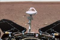
That's the backshell of the lander. A better image is here.
|
 |
 
|
|
May 4 2023, 05:38 AM
Post
#402
|
|
|
Founder Group: Chairman Posts: 14432 Joined: 8-February 04 Member No.: 1 |
QUOTE (tanjent @ May 3 2023, 07:09 PM)  I guess they don't come with time stamps, If you look at the file names on the Smugmug page you'll see I pruned the start of the file name for the first image of the mosaic - but it contains a time stamp i.e. SCI_N_20210603090152_20210603090152_00020_A Panorama.jpg That's June 3rd 2021 at 09:01:52 |
|
|
|
|
May 4 2023, 10:45 PM
Post
#403
|
|||
|
Solar System Cartographer Group: Members Posts: 10170 Joined: 5-April 05 From: Canada Member No.: 227 |
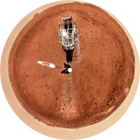
Thanks for all this, Doug. Naturally I couldn't pass up the chance to make a circular version. The first one, for now.
Phil
-------------------- ... because the Solar System ain't gonna map itself.
Also to be found posting similar content on https://mastodon.social/@PhilStooke Maps for download (free PD: https://upload.wikimedia.org/wikipedia/comm...Cartography.pdf NOTE: everything created by me which I post on UMSF is considered to be in the public domain (NOT CC, public domain) |
||
|
|
|
||
|
May 5 2023, 09:25 PM
Post
#404
|
|
 Member Group: Members Posts: 121 Joined: 19-November 14 From: Québec Member No.: 7339 |
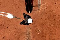
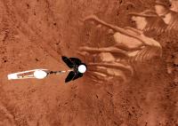
QUOTE (djellison @ Apr 30 2023, 11:16 PM) I've posted details of the 800 image drop here : https://deepspace.social/@doug_ellison/110291433371702521 good jobI literally ended up using a mouse-record-and-replay tool to hit 'download' on each of the 5 products per page, then hitting next page and let it repeat for ~160 pages  Seems like ~14 360 mosaics over ~5 months were taken - with 3x1 mosaics for drive direction for a few steps in-between each 360 Attached - a bunch of them at ~1/3rd res - full size I've posted here : https://dougellison.smugmug.com/Zhurong-Panoramas/ -------------------- |
|
|
|
|
May 6 2023, 02:10 AM
Post
#405
|
|||
|
Solar System Cartographer Group: Members Posts: 10170 Joined: 5-April 05 From: Canada Member No.: 227 |
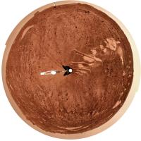
Here is the panorama for --- in circular form.
Phil
-------------------- ... because the Solar System ain't gonna map itself.
Also to be found posting similar content on https://mastodon.social/@PhilStooke Maps for download (free PD: https://upload.wikimedia.org/wikipedia/comm...Cartography.pdf NOTE: everything created by me which I post on UMSF is considered to be in the public domain (NOT CC, public domain) |
||
|
|
|
||
|
May 6 2023, 07:08 AM
Post
#406
|
|
 Member Group: Members Posts: 227 Joined: 13-October 09 From: Olympus Mons Member No.: 4972 |
Looks like an alligator mouth
-------------------- "Thats no moon... IT'S A TRAP!"
|
|
|
|
|
May 7 2023, 07:33 PM
Post
#407
|
|
 Member Group: Members Posts: 611 Joined: 23-February 07 From: Occasionally in Columbia, MD Member No.: 1764 |
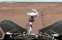
QUOTE (djellison @ May 1 2023, 12:16 AM) .... Seems like ~14 360 mosaics over ~5 months were taken - with 3x1 mosaics for drive direction for a few steps in-between each 360 Attached - a bunch of them at ~1/3rd res - These are fantastic, Doug! I love how one panorama has rover structure in the foreground, and on the horizon you can see the lander and the backshell. And that the near-lander one has the little selfiecam sitting on the ground between the tracks... |
|
|
|
|
May 10 2023, 11:46 PM
Post
#408
|
|||||
 Member Group: Members Posts: 185 Joined: 4-January 19 Member No.: 8523 |
It is interesting to compare first and last panoramas.
The ammount of dust on the solar array and mast is impressive.
Attached thumbnail(s)
-------------------- "The Earth is a very small stage in a vast cosmic arena"
|
||||
|
|
|
||||
|
May 18 2023, 10:48 PM
Post
#409
|
|
|
Senior Member Group: Members Posts: 2998 Joined: 30-October 04 Member No.: 105 |
Huguet, if those three images are all, then that is not a great deal of dust. Pre-cleaning by dust devils, Spirit and Oppy could have more dust.
Wasn't Zurgong supposed to have a vibrating device in the solar panels to clear dust deposited? -------------------- |
|
|
|
|
May 18 2023, 11:07 PM
Post
#410
|
|
|
Solar System Cartographer Group: Members Posts: 10170 Joined: 5-April 05 From: Canada Member No.: 227 |
A tilting device, I think. But it doesn't help if the dust accumulates during a winter shutdown and then the rover can't wake up to use the device.
Phil -------------------- ... because the Solar System ain't gonna map itself.
Also to be found posting similar content on https://mastodon.social/@PhilStooke Maps for download (free PD: https://upload.wikimedia.org/wikipedia/comm...Cartography.pdf NOTE: everything created by me which I post on UMSF is considered to be in the public domain (NOT CC, public domain) |
|
|
|
|
May 24 2023, 11:19 AM
Post
#411
|
|
|
Member Group: Members Posts: 104 Joined: 3-February 20 From: Paris (France) Member No.: 8747 |
Bonjour,
An in-situ observation made by Zhurtong would attest to the reality of a Martian paleo-ocean https://academic.oup.com/nsr/advance-articl...482?login=false https://phys.org/news/2023-05-in-situ-marin...t-northern.html |
|
|
|
|
May 26 2023, 10:54 PM
Post
#412
|
|
|
Senior Member Group: Members Posts: 1044 Joined: 17-February 09 Member No.: 4605 |
Thanks for the links. The sedimentary evidence is compelling and combined with all other evidence confirms the existence of the Northern basin ocean. The conflict between the faint young sun hypothesis, a warm wet early Mars and no compelling greenhouse gas explanation will continue to drive researches crazy.
|
|
|
|
|
Jun 7 2023, 04:09 AM
Post
#413
|
||
|
Solar System Cartographer Group: Members Posts: 10170 Joined: 5-April 05 From: Canada Member No.: 227 |
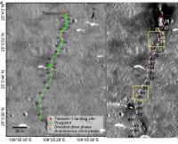
I am working on the Tianwen-1/Zhurong section of my book, hoping to created an accurate map of the whole traverse. I think by now, a year without any movement of the rover, we can consider the surface mission over.
But trying to nail down which sol the rover was at each location is very difficult. Consider these two published maps:
The map on the left is from: Ding, L., Zhou, R., Yu, T., Gao, H., Yang, H., Li, J., Yuan, Y., Liu, C., Wang, J., Zhao, Y.Y. and Wang, Z., 2022. Surface characteristics of the Zhurong Mars rover traverse at Utopia Planitia. Nature Geoscience, 15(3), pp.171-176. https://doi.org/10.1038/s41561-022-00905-6 The map on the right is from: Chen, R., Zhang, L., Xu, Y., Liu, R., Bugiolacchi, R., Zhang, X., Chen, L., Zeng, Z. and Liu, C., 2023. Martian soil as revealed by ground-penetrating radar at the Tianwen-1 landing site. Geology, 51(3), pp.315-319. https://doi.org/10.1130/G50632.1 These are both good papers in top journals, but their maps do not agree.Look at the point labelled 59 on the left. It corresponds with the point labelled 60 on the right. A one sol difference might be the result of starting the mission with landing on sol 0 or sol 1 in different sources, and there does seem to be confusion about that. In the early sols I thought the landing was on sol 0, but I don't recall where that came from. The Ding paper, which includes a table of activities for sols 1-60, uses sol 1, and I will be working with that now. A one sol difference also might arise from the 'park, sleep, study, drive' sequence we see on NASA rovers. Curiosity, for instance, might drive and park for the night on sol 1000, make science observations on the next morning and then drive again, putting sol 1001 observations and target names at the sol 1000 location. All us poor rover mappers have had to deal with that. But then look at the twisty bit of the path labelled 28-29-30 on the left. The corresponding points on the right are 30-31-33. It is very unfortunate that the mission team have not released an official map so that everyone - Chinese scientists as well as everyone else - can work with the same data. I am going to try some contacts in China. Phil -------------------- ... because the Solar System ain't gonna map itself.
Also to be found posting similar content on https://mastodon.social/@PhilStooke Maps for download (free PD: https://upload.wikimedia.org/wikipedia/comm...Cartography.pdf NOTE: everything created by me which I post on UMSF is considered to be in the public domain (NOT CC, public domain) |
|
|
|
|
|
|
Jun 11 2023, 06:46 PM
Post
#414
|
|
|
Senior Member Group: Members Posts: 2998 Joined: 30-October 04 Member No.: 105 |
You've probably already tried this, but overlay the two maps, aligning on topo features, with the yracks in different colors or with clickable visibility, and try to sort things out.
The mission was quite impressive. --Bill -------------------- |
|
|
|
|
Jun 11 2023, 07:37 PM
Post
#415
|
|
|
Solar System Cartographer Group: Members Posts: 10170 Joined: 5-April 05 From: Canada Member No.: 227 |
No, that doesn't change things.
Long Xiao has told me that the answer is that Zhurong may spend 2 or 3 sols at one place making observations, and the differing dates in different papers are observation dates at that point. His recent paper on marine sediments also had dates which differ a bit from either of those sources I linked to. This helps, and I will try a canonical map giving what I think are actual dates at each location, but I think there are still going to be some discrepancies. More to come. -------------------- ... because the Solar System ain't gonna map itself.
Also to be found posting similar content on https://mastodon.social/@PhilStooke Maps for download (free PD: https://upload.wikimedia.org/wikipedia/comm...Cartography.pdf NOTE: everything created by me which I post on UMSF is considered to be in the public domain (NOT CC, public domain) |
|
|
|
|

|
Lo-Fi Version | Time is now: 28th May 2024 - 02:12 AM |
|
RULES AND GUIDELINES Please read the Forum Rules and Guidelines before posting. IMAGE COPYRIGHT |
OPINIONS AND MODERATION Opinions expressed on UnmannedSpaceflight.com are those of the individual posters and do not necessarily reflect the opinions of UnmannedSpaceflight.com or The Planetary Society. The all-volunteer UnmannedSpaceflight.com moderation team is wholly independent of The Planetary Society. The Planetary Society has no influence over decisions made by the UnmannedSpaceflight.com moderators. |
SUPPORT THE FORUM Unmannedspaceflight.com is funded by the Planetary Society. Please consider supporting our work and many other projects by donating to the Society or becoming a member. |
|