Traverse to the Delta, sols 379-414, 15 Mar 2022- 21 Apr 2022 |

  |
Traverse to the Delta, sols 379-414, 15 Mar 2022- 21 Apr 2022 |
 Apr 12 2022, 06:08 PM Apr 12 2022, 06:08 PM
Post
#106
|
||
|
Junior Member  Group: Members Posts: 75 Joined: 8-July 15 Member No.: 7566 |
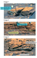
QUOTE (tau @ Apr 12 2022, 01:54 PM)  97 new Mastcam-Z raw images of the delta from sol 306 just arrived. Here are three of them, specially selected for the "inner sedimentologist" of Saturns Moon Titan, in a processed version. A note for new visitors: the blue color of some of the stones in the images is due to color enhancement. In reality they are more gray or brownish gray. Thank you for processing these images tau they're great!  I should say that I'm not a sedimentologist, I'm more trained in analysis of orbital imagery, but I did attend the rover sessions at LPSC this year and I'll be helping with Perseverance operations when I start my PhD this fall. At LPSC the expectation, from long-distance imagery of these very same outcrops, was that they would be pro-delta (lakebed, deep water) mudstones. This was on the basis of their horizontal bedding and position at the very base of the delta (unlike the delta scarp stuff above which is often steeply inclined and represents delta front sandstones). I actually think these new images contradict that hypothesis. The first image shows a conglomerate slab including at least two boulder-sized clasts that resembles what we saw a few days ago, however it's not clear this outcrop is in-situ and it might have slid down from higher up. The second image however is clearly in-situ and I believe it does not show a prodelta deposit but rather a fluvial or delta front deposit. This is because there is large-scale truncation surfaces and seem to be pebble or cobble-sized clasts embedded within it, all of which is consistent with sandstone rather than mudstone. However some of the horizontally laminated intervals might contain muds and silts interbedded with sands. The third image is the most enigmatic and scientifically interesting. There is a weird large undulation, and I'm really not sure what it could be. But since there's no folding on Mars this must be some kind of sedimentary bedform. To the left, the inclination of the bedding appears alarmingly steep, but I suspect this is an illusion due to foreshortening/perspective. There is also an unusual lithology here, it could be a massive (internally structure-less) sandstone bed or perhaps the elusive mudstones, just laminated so thinly the resolution is too poor to pick it out. This has implications for the future of the mission. The idea that Perseverance would be able to access prodelta mudstones is kind of the whole reason the rover was sent to Jezero, because those clay-rich deposits have high potential for preserving biosignatures. But in my opinion, at this distance, these outcrops look to still be predominantly the sandy delta front, even though they're near the base of the delta scarp. Perseverance is not going to be approaching these outcrops though, so I guess that's not super relevant. Hopefully, at the base of the 'three forks' area, Perseverance will encounter the muddy prodelta deposit that the astrobiologists are so eager to drill.
|
|
 |
 
|
|
|
Apr 12 2022, 08:14 PM
Post
#107
|
|
 Member Group: Members Posts: 809 Joined: 3-June 04 From: Brittany, France Member No.: 79 |
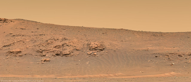
Panorama taken with Mastcam-Z Left on sol 406 at 9:30 am LMST. It's a pleasure to zoom in to dive into the wealth of details!

-------------------- |
|
|
|
|
Apr 12 2022, 08:38 PM
Post
#108
|
|
|
Solar System Cartographer Group: Members Posts: 10151 Joined: 5-April 05 From: Canada Member No.: 227 |
The curving structure in Tau's third image might represent deformation of the soft sediments during slumping. Very cool to see these things.
Phil -------------------- ... because the Solar System ain't gonna map itself.
Also to be found posting similar content on https://mastodon.social/@PhilStooke Maps for download (free PD: https://upload.wikimedia.org/wikipedia/comm...Cartography.pdf NOTE: everything created by me which I post on UMSF is considered to be in the public domain (NOT CC, public domain) |
|
|
|
|
Apr 12 2022, 08:40 PM
Post
#109
|
||
|
Newbie Group: Members Posts: 12 Joined: 15-August 12 Member No.: 6562 |
QUOTE (Saturns Moon Titan @ Apr 12 2022, 07:08 PM) Thank you for processing these images tau they're great! I should say that I'm not a sedimentologist, I'm more trained in analysis of orbital imagery, but I did attend the rover sessions at LPSC this year and I'll be helping with Perseverance operations when I start my PhD this fall. At LPSC the expectation, from long-distance imagery of these very same outcrops, was that they would be pro-delta (lakebed, deep water) mudstones. This was on the basis of their horizontal bedding and position at the very base of the delta (unlike the delta scarp stuff above which is often steeply inclined and represents delta front sandstones). I actually think these new images contradict that hypothesis. The first image shows a conglomerate slab including at least two boulder-sized clasts that resembles what we saw a few days ago, however it's not clear this outcrop is in-situ and it might have slid down from higher up. The second image however is clearly in-situ and I believe it does not show a prodelta deposit but rather a fluvial or delta front deposit. This is because there is large-scale truncation surfaces and seem to be pebble or cobble-sized clasts embedded within it, all of which is consistent with sandstone rather than mudstone. However some of the horizontally laminated intervals might contain muds and silts interbedded with sands. The third image is the most enigmatic and scientifically interesting. There is a weird large undulation, and I'm really not sure what it could be. But since there's no folding on Mars this must be some kind of sedimentary bedform. To the left, the inclination of the bedding appears alarmingly steep, but I suspect this is an illusion due to foreshortening/perspective. There is also an unusual lithology here, it could be a massive (internally structure-less) sandstone bed or perhaps the elusive mudstones, just laminated so thinly the resolution is too poor to pick it out. This has implications for the future of the mission. The idea that Perseverance would be able to access prodelta mudstones is kind of the whole reason the rover was sent to Jezero, because those clay-rich deposits have high potential for preserving biosignatures. But in my opinion, at this distance, these outcrops look to still be predominantly the sandy delta front, even though they're near the base of the delta scarp. Perseverance is not going to be approaching these outcrops though, so I guess that's not super relevant. Hopefully, at the base of the 'three forks' area, Perseverance will encounter the muddy prodelta deposit that the astrobiologists are so eager to drill.
My guess, only looking at this image, is that the fold could be some kind of turbidite/slumping. These processes are able to create "folds" in active delta enviroments. |
|
|
|
|
|
|
Apr 12 2022, 11:25 PM
Post
#110
|
|
|
Senior Member Group: Members Posts: 1043 Joined: 17-February 09 Member No.: 4605 |
Looking at the context of this deposit in Neo56's cool panorama it does appear to be localized laterally, extending back into the delta. Possibly a channelised deposit of mudstone rich sediment that had been eroded and transported from a pre-existing deposit?
|
|
|
|
|
Apr 12 2022, 11:40 PM
Post
#111
|
|||
|
Junior Member Group: Members Posts: 75 Joined: 8-July 15 Member No.: 7566 |
QUOTE (neo56 @ Apr 12 2022, 09:14 PM) Panorama taken with Mastcam-Z Left on sol 406 at 9:30 am LMST. It's a pleasure to zoom in to dive into the wealth of details! Incredible panorama, Mastcam-Z really is a wonderful instrument. I encourage everyone to download the high resolution version and zoom around. There's way too much interesting stuff here for me to bother annotating (I think an entire PhD thesis could be written using this panorama alone) however I found a couple of interesting things that are at the edges of the panorama, away from the 'main action', that you might not have noticed: at the far-left of the panorama, on a very distant part of the delta scarp, there's a textbook-tier erosional unconformity. Since the rover is driving in this general direction the image resolution of this feature should improve a lot over the coming weeks.
at the upper right, there's an oblique view of the boulder conglomerate capping unit that the rover was parallel with a few days ago. This along-strike perspective reveals that, like the delta front sandstones below it, the conglomerate deposit is dipping pretty steeply southwards. This strongly suggests that the lake level dropped significantly (perhaps entirely drying out), because the flash flood carrying all these boulders is cascading down the slope of the delta front. It would have been a spectacular and dramatic sight - a waterfall carrying meter-sized boulders. Jezero Crater was home to some violent floods far more powerful than anything we've ever seen at Gale Crater.
|
||
|
|
|
||
|
Apr 13 2022, 12:48 AM
Post
#112
|
|
 Member Group: Members Posts: 699 Joined: 3-December 04 From: Boulder, Colorado, USA Member No.: 117 |
The images of the conglomerate bed are wonderful- too bad the bed got clipped by the mosaic edge. Are you sure it's steeply dipping, or is is it just an illusion due to our very oblique look angle?
John |
|
|
|
|
Apr 13 2022, 08:15 AM
Post
#113
|
|
|
Junior Member Group: Members Posts: 75 Joined: 8-July 15 Member No.: 7566 |
Fair question actually, that's possible. I'm quite certain the sandstone beds below it are dipping steeply but, with only a small part of the conglomerate-sandstone contact in view, it is possible the apparent conglomerate dip is just a trick of perspective. The mission team will know the answer because they'll be generating digital elevation models as they go along.
|
|
|
|
|
Apr 13 2022, 05:34 PM
Post
#114
|
|
|
Member Group: Members Posts: 809 Joined: 3-June 04 From: Brittany, France Member No.: 79 |
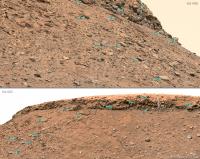
Three cropped versions of the huge Mastcam-Z panorama of sol 406.
-------------------- |
|
|
|
|
Apr 13 2022, 05:48 PM
Post
#115
|
|
|
Senior Member Group: Members Posts: 2998 Joined: 30-October 04 Member No.: 105 |
QUOTE (Phil Stooke @ Apr 12 2022, 03:38 PM) The curving structure in Tau's third image might represent deformation of the soft sediments during slumping. Very cool to see these things. Phil I'd think slumping and turbidites, also. "Jezero Creek" is depositing a lot of sediment in flash or ephemeral flows, and also doing a lot of erosion and canyon cutting once it drops it's load. This is an unstable scenario and we're going to see slumping. --Bill -------------------- |
|
|
|
|
Apr 13 2022, 08:35 PM
Post
#116
|
||
 Member Group: Members Posts: 664 Joined: 9-May 21 From: Germany Member No.: 9017 |
QUOTE (john_s @ Apr 13 2022, 02:48 AM) The images of the conglomerate bed are wonderful- too bad the bed got clipped by the mosaic edge. Are you sure it's steeply dipping, or is is it just an illusion due to our very oblique look angle? QUOTE (Saturns Moon Titan @ Apr 13 2022, 10:15 AM) Fair question actually, that's possible. I'm quite certain the sandstone beds below it are dipping steeply but, with only a small part of the conglomerate-sandstone contact in view, it is possible the apparent conglomerate dip is just a trick of perspective. . . . A comparison with an image from a greater distance on sol 402 shows that this is only a perspective effect, albeit a very impressive one. When I first saw the sol 406 image, my eyes were fooled too. The conglomerate-sandstone contact is - at least in this place - nearly horizontal. The digital terrain model indicates an inclination of the slope below the conglomerate of 30° to almost 40° to the east-southeast.
|
|
|
|
|
|
|
Apr 14 2022, 02:23 AM
Post
#117
|
||
|
Solar System Cartographer Group: Members Posts: 10151 Joined: 5-April 05 From: Canada Member No.: 227 |
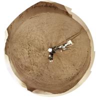
Great pictures of a wonderful landscape. Here is the sol 407 circular panorama.
Looking ahead, it's not going to be easy to climb up onto the delta. It will be interesting to see how we do it. Phil
-------------------- ... because the Solar System ain't gonna map itself.
Also to be found posting similar content on https://mastodon.social/@PhilStooke Maps for download (free PD: https://upload.wikimedia.org/wikipedia/comm...Cartography.pdf NOTE: everything created by me which I post on UMSF is considered to be in the public domain (NOT CC, public domain) |
|
|
|
|
|
|
Apr 14 2022, 04:28 AM
Post
#118
|
|
|
Member Group: Members Posts: 228 Joined: 14-January 22 Member No.: 9140 |
The east face of the delta looks completely impossible to climb. Planned traverse routes from the team show paths entering the area from the south face, which we haven't seen yet from the ground. It looks like it will involve six to ten relatively punctuated climbs. It certainly seems daunting unless those unseen slopes are very different from the ones we've seen so far.
|
|
|
|
|
Apr 14 2022, 06:14 AM
Post
#119
|
|
|
Solar System Cartographer Group: Members Posts: 10151 Joined: 5-April 05 From: Canada Member No.: 227 |
We haven't seen it from the ground, but I am looking ahead in HiRISE images. It is presumably possible but it's going to be tricky.
Phil -------------------- ... because the Solar System ain't gonna map itself.
Also to be found posting similar content on https://mastodon.social/@PhilStooke Maps for download (free PD: https://upload.wikimedia.org/wikipedia/comm...Cartography.pdf NOTE: everything created by me which I post on UMSF is considered to be in the public domain (NOT CC, public domain) |
|
|
|
|
Apr 14 2022, 06:43 AM
Post
#120
|
|
|
Member Group: Members Posts: 362 Joined: 13-April 06 From: Malta Member No.: 741 |
I am starting to wonder whether could this all be due to sporadic water activity related to ongoing volcanism from nearby volcanic province of Syrtis Major rather than a warm wet Mars!?
|
|
|
|
|

|
Lo-Fi Version | Time is now: 25th April 2024 - 12:27 AM |
|
RULES AND GUIDELINES Please read the Forum Rules and Guidelines before posting. IMAGE COPYRIGHT |
OPINIONS AND MODERATION Opinions expressed on UnmannedSpaceflight.com are those of the individual posters and do not necessarily reflect the opinions of UnmannedSpaceflight.com or The Planetary Society. The all-volunteer UnmannedSpaceflight.com moderation team is wholly independent of The Planetary Society. The Planetary Society has no influence over decisions made by the UnmannedSpaceflight.com moderators. |
SUPPORT THE FORUM Unmannedspaceflight.com is funded by the Planetary Society. Please consider supporting our work and many other projects by donating to the Society or becoming a member. |
|