Reprocessing Historical Images, Looking for REALLY big challenges? |

  |
Reprocessing Historical Images, Looking for REALLY big challenges? |
 Jun 3 2005, 03:39 AM Jun 3 2005, 03:39 AM
Post
#101
|
|
|
Solar System Cartographer  Group: Members Posts: 10190 Joined: 5-April 05 From: Canada Member No.: 227 |
The Soviets also made map-projected versions of the pans, but they appeared only in obscure publications. It's too bad they didn't get more widespread publicity, but maybe we will be able to create the definitive maps ourselves now. These venera images were, and still are, a remarkable achievement.
It is interesting to look ahead to what could be done in future. The Veneras dropped blindly onto an essentially unknown surface, but future probes could be targeted for specific geologic units. If we could get a simple probe with a bit of surface chemistry, descent imaging and a high resolution pan in areas of known geologic context we would get to know Venus a lot better. That sort of mission should be well within the Discovery budget as it's very short and landing is easy. Phil -------------------- ... because the Solar System ain't gonna map itself.
Also to be found posting similar content on https://mastodon.social/@PhilStooke Maps for download (free PD: https://upload.wikimedia.org/wikipedia/comm...Cartography.pdf NOTE: everything created by me which I post on UMSF is considered to be in the public domain (NOT CC, public domain) |
 |
 
|
|
Jun 3 2005, 03:48 AM
Post
#102
|
|
 Interplanetary Dumpster Diver Group: Admin Posts: 4404 Joined: 17-February 04 From: Powell, TN Member No.: 33 |
QUOTE (Phil Stooke @ Jun 3 2005, 03:39 AM) The Soviets also made map-projected versions of the pans, but they appeared only in obscure publications. It's too bad they didn't get more widespread publicity, but maybe we will be able to create the definitive maps ourselves now. These venera images were, and still are, a remarkable achievement. It is interesting to look ahead to what could be done in future. The Veneras dropped blindly onto an essentially unknown surface, but future probes could be targeted for specific geologic units. If we could get a simple probe with a bit of surface chemistry, descent imaging and a high resolution pan in areas of known geologic context we would get to know Venus a lot better. That sort of mission should be well within the Discovery budget as it's very short and landing is easy. Phil  It is a shame that hasn't happened. By the way, there are some scans of some bad reproductions of those images you spoke of (V9/V10) 
-------------------- |
|
|
|
|
Jun 3 2005, 05:32 AM
Post
#103
|
|
 Member Group: Members Posts: 259 Joined: 23-January 05 From: Seattle, WA Member No.: 156 |
QUOTE (Phil Stooke @ Jun 3 2005, 03:39 AM) ... If we could get a simple probe with a bit of surface chemistry, descent imaging and a high resolution pan in areas of known geologic context we would get to know Venus a lot better. That sort of mission should be well within the Discovery budget as it's very short and landing is easy. ... On the off chance someone here hasn't seen it, there's a Venus Geophysical Lander proposal from the 1990s at Malin Space Science Systems. |
|
|
|
|
Jun 3 2005, 07:34 AM
Post
#104
|
|
 Senior Member Group: Members Posts: 3419 Joined: 9-February 04 From: Minneapolis, MN, USA Member No.: 15 |
QUOTE (Phil Stooke @ Jun 2 2005, 10:39 PM) ...It is interesting to look ahead to what could be done in future. The Veneras dropped blindly onto an essentially unknown surface, but future probes could be targeted for specific geologic units. If we could get a simple probe with a bit of surface chemistry, descent imaging and a high resolution pan in areas of known geologic context we would get to know Venus a lot better. That sort of mission should be well within the Discovery budget as it's very short and landing is easy. Phil Landing may be easy, but surviving very long after landing is not. It's not just hot with very high pressures down there on the surface, it's very chemically reactive, too. For such a geologically young surface, have you noticed how nearly all of Venera landing sites feature rocks that have been flattened right down to the ground? The conditions on the surface of Venus grind the very rocks down to flat, even surfaces. That's what I call a hostile environment. And exactly how close are we to developing "heat-proof electronics," anyway? It's not like designing a spacecraft to endure solar heating from, say, Mercury's orbit, since any spacecraft in a vacuum has a shadowed side that can be used to dump heat. It's much more difficult to cool something when it's got superheated air or rock on all sides and all exterior surfaces. I just think it's premature to think about roving vehicles on Venus. The balloon-lifted drop-and-grab probe, however, is an excellent idea and much easier to design -- it lets you store heat temporarily and then get rid of it after the probe ascends to cooler levels of the atmosphere. That's a far less challenging engineering problem than trying to operate continually in such an environment for more than a few hours... -the other Doug -------------------- The trouble ain't that there is too many fools, but that the lightning ain't distributed right. -Mark Twain
|
|
|
|
|
Jun 3 2005, 08:05 AM
Post
#105
|
|
|
Senior Member Group: Members Posts: 3419 Joined: 9-February 04 From: Minneapolis, MN, USA Member No.: 15 |
QUOTE (Phil Stooke @ Jun 2 2005, 02:56 PM) Another Surveyor 5 scene. This goes out to the horizon north of the lander. [attachment=628:attachment] Phil I guess a mare is a mare is a mare, but it realy strikes me how closely Surveyor V's patch of the Sea of Tranquility resembles Apollo 11's patch. Of course, Surveyor V's horizon is a bit closer than that of Tranquility Base, since it's sitting in a shallow crater. I know they refired the verniers on Surveyor V, but didn't try a hop like they did on Surveyor VI (I think because they had a power issue that ensured it wouldn't survive more than about the length of the lunar day). But wouldn't it have been cool if a Surveyor could have hopped itself out of a shallow crater and improve its viewpoint? -the other Doug -------------------- The trouble ain't that there is too many fools, but that the lightning ain't distributed right. -Mark Twain
|
|
|
|
|
Jun 3 2005, 10:05 AM
Post
#106
|
|
 Member Group: Members Posts: 255 Joined: 4-January 05 Member No.: 135 |
QUOTE (dvandorn @ Jun 3 2005, 07:34 AM) And exactly how close are we to developing "heat-proof electronics," anyway? -the other Doug Mike Malin's proposal has multi-stage refrigeration. Well worth a read. Chris |
|
|
|
|
Jun 3 2005, 10:24 AM
Post
#107
|
||
|
Member Group: Members Posts: 194 Joined: 8-February 04 Member No.: 10 |
[quote=tedstryk,Jun 3 2005, 03:48 AM]
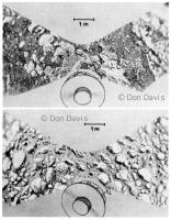
It is a shame that hasn't happened. By the way, there are some scans of some bad reproductions of those images you spoke of (V9/V10) And here are my ink drawings of overhead views of the Venera sites, all hand plotted and drawn. These are scanned (although I still have the originals) from 'The New Solar System by Sky Publishing 1st ed. 1981. I largely used as reference a set of Russian prints given me by Hal Mazursky which revealed unusual details in the foregrounds, particularly the cracked 'broken pavement' rocks in Venera 10. The Venera 10 print appears here: http://www.donaldedavis.com/BIGPUB/V10.jpg Although later recent versions of the Venera images are clearly superior, I used the best material available for twenty years. I have also made a set of similar drawings of the Viking sites, which appeared once in The Planetary Report. I will dig up my copies of the sample field maps with the various rock nicknames which Henry Moore gave me. Don
Attached thumbnail(s)
|
|
|
|
|
|
|
Jun 3 2005, 10:38 AM
Post
#108
|
|
|
Member Group: Members Posts: 378 Joined: 21-April 05 From: Portugal Member No.: 347 |
QUOTE (tedstryk @ Jun 3 2005, 03:54 AM) ...If you look near where the images touch, you will notice the doublet features. Also, the curvature of the pans is backwards... Yes, my corrections are far from perfect. Some features are doubled, but I didn't even tried to correct it. Perhaps we could create some 3d images with this data  As for the curvature, I thought the same at first. But notice that the camera scan moves from the horizon down to a point in the ground in front of the lander (in a diagonal down to the right) and then back up (in a diagonal up to the right). At least this is what I can make out based on Don's diagram. But I'll look into this! I had seen some reprojections of V13 data but not this V9 & V10 scans you posted. What troubles me is that this type of projection distorts the surface near the lander and looks very different from what a "normal" camera would photograph. The same can be said for the Pathfinder pan. You are viewing a 360x100º (a guess, but there's just a little sky area visible above the horizon) on a computer monitor. Normally we use this to display 40ºx30º images! -------------------- _______________________
www.astrosurf.com/nunes |
|
|
|
|
Jun 3 2005, 10:50 AM
Post
#109
|
|
|
Member Group: Members Posts: 378 Joined: 21-April 05 From: Portugal Member No.: 347 |
QUOTE (DDAVIS @ Jun 3 2005, 11:24 AM) And here are my ink drawings of overhead views of the Venera sites, all hand plotted and drawn. Very nice!!! This look very accurate as opposed to the overhead views generated from the photos posted by Tedstryk that look kind of distorted. -------------------- _______________________
www.astrosurf.com/nunes |
|
|
|
|
Jun 3 2005, 02:22 PM
Post
#110
|
||
|
Solar System Cartographer Group: Members Posts: 10190 Joined: 5-April 05 From: Canada Member No.: 227 |
Here is my last Surveyor 5 effort. The horizon south of the landing site.
Phil -------------------- ... because the Solar System ain't gonna map itself.
Also to be found posting similar content on https://mastodon.social/@PhilStooke Maps for download (free PD: https://upload.wikimedia.org/wikipedia/comm...Cartography.pdf NOTE: everything created by me which I post on UMSF is considered to be in the public domain (NOT CC, public domain) |
|
|
|
|
|
|
Jun 3 2005, 03:07 PM
Post
#111
|
|
 Senior Member Group: Members Posts: 2488 Joined: 17-April 05 From: Glasgow, Scotland, UK Member No.: 239 |
QUOTE (Gsnorgathon @ Jun 3 2005, 06:32 AM) On the off chance someone here hasn't seen it, there's a Venus Geophysical Lander proposal from the 1990s at Malin Space Science Systems. It looks like the old Voyager-Mars design! Smaller, though... -------------------- Remember: Time Flies like the wind - but Fruit Flies like bananas!
|
|
|
|
|
Jun 3 2005, 06:25 PM
Post
#112
|
||
|
Interplanetary Dumpster Diver Group: Admin Posts: 4404 Joined: 17-February 04 From: Powell, TN Member No.: 33 |
QUOTE (Phil Stooke @ Jun 3 2005, 02:22 PM) Here is my last Surveyor 5 effort. The horizon south of the landing site.
Phil Great pan! -------------------- |
|
|
|
|
|
|
Jun 3 2005, 06:27 PM
Post
#113
|
|
|
Interplanetary Dumpster Diver Group: Admin Posts: 4404 Joined: 17-February 04 From: Powell, TN Member No.: 33 |
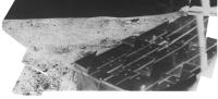
Here is a first result of the Surveyor 7 work I am doing. It is a cleanup of a single S-7 frame. More to come, but this could take a while.

-------------------- |
|
|
|
|
Jun 3 2005, 08:16 PM
Post
#114
|
|
|
Solar System Cartographer Group: Members Posts: 10190 Joined: 5-April 05 From: Canada Member No.: 227 |
That's really nice, Ted. I found it on my full-size pan... it it SSE of the lander, looking back towards the rim of Tycho, but all we see is a rocky ridge one or two hundred meters away.
Will your images fit together to make a section of a pan? Phil -------------------- ... because the Solar System ain't gonna map itself.
Also to be found posting similar content on https://mastodon.social/@PhilStooke Maps for download (free PD: https://upload.wikimedia.org/wikipedia/comm...Cartography.pdf NOTE: everything created by me which I post on UMSF is considered to be in the public domain (NOT CC, public domain) |
|
|
|
|
Jun 3 2005, 08:18 PM
Post
#115
|
|
 Senior Member Group: Members Posts: 2530 Joined: 20-April 05 Member No.: 321 |
QUOTE (GregM @ Jun 2 2005, 07:51 PM) I think you just may have figured it out! Excellent work! If the Soviets in the 70' and 80's had figured out how reproject and rectify their own Venera images in the excellent ways seen in this forum, they would have scored a much bigger propaganda coup than what they did! Their loss then - our gain now! I'm sure the Soviets were capable of that -- this is more like a one-night homework assignment for a math/engineering class than a serious technical challenge. Of course, they could have simply designed a camera that panned a horizontal view in the first place -- I have always assumed that the design they used was to assure scientific value per second, on craft whose lifetimes were bound to be brief. Namely, this method of scan gives a quick look at the whole continuum of distance/angle from spacecraft -- much the same as the multiple viewers on Huygens achieved. I always assumed that this showed that the Soviets were entirely interested in producing science value, PR-be-damned. (Of course, they did and rightly should have trumpted the historic nature of these images, but they showed no need to make "eye candy" out of them when a little spin doctoring in print would do just as well.) The specs of the cameras (for V13/14, anyway) can be seen here http://nssdc.gsfc.nasa.gov/database/Master...=1981-106D&ex=1 |
|
|
|
|

|
Lo-Fi Version | Time is now: 8th June 2024 - 05:41 PM |
|
RULES AND GUIDELINES Please read the Forum Rules and Guidelines before posting. IMAGE COPYRIGHT |
OPINIONS AND MODERATION Opinions expressed on UnmannedSpaceflight.com are those of the individual posters and do not necessarily reflect the opinions of UnmannedSpaceflight.com or The Planetary Society. The all-volunteer UnmannedSpaceflight.com moderation team is wholly independent of The Planetary Society. The Planetary Society has no influence over decisions made by the UnmannedSpaceflight.com moderators. |
SUPPORT THE FORUM Unmannedspaceflight.com is funded by the Planetary Society. Please consider supporting our work and many other projects by donating to the Society or becoming a member. |
|