Spirit Clouds In Latest Pancam Images ? |

  |
Spirit Clouds In Latest Pancam Images ? |
 May 2 2005, 08:15 PM May 2 2005, 08:15 PM
Post
#16
|
|
|
Member  Group: Members Posts: 713 Joined: 30-March 05 Member No.: 223 |
I too have always been fascinated by the question how the martin sky would really look like beacuse none of the spacecraft so far has provided a
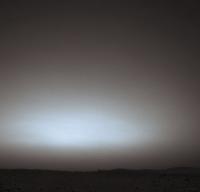
real wide-angle view of the sky *including* ground/horizon parts. Although the MER's have already collected very extensive sky studies with the pancam, most of it were isolated strips or the parts around the sun. So, because of the contrast streching, that does not tell us much how the big picture would look like in composition with the ground. For a long time I was a strong advocate of the "nearly-black-sky-not-far-away-from-horizon"- fraction (it's just hard to imagine else when considering an atmosphere more than one hundred times thinner than earth's) In the mean time I have collected quite a few rover images, that do show a considerable angle of sky away from the horizon, and it's interesting how much this seems to support the "black-sky"-thesis, e.g.: http://marsrovers.jpl.nasa.gov/gallery/pre..._Opp-B163R1.jpg http://marsrovers.jpl.nasa.gov/gallery/all...46P0833R0M1.JPG remarks: 1. as already pointed out, the "absolute blackness-level" is probably exagerated by the contrast stretching (would be easy to resolve by looking at the raw/ radiance calibrated images) However, Contrast stretching tends to darken *all* black/dark parts of the image, i.e. the shadoes of the rocks: so in the images above, the sky appears at least as dark than the shadows of the rocks. 2. Vignetting effects of the camera lens towards the edges of the field of view can also contribute to the "black-sky" effect. However in the images above it is obvious that the "blackening" already starts in the middle of the field of view So in summary, I tend to imagine the sky as bright near horizon, but getting near black very soon, with a sharp gradient. However this is probably only so during relatively dust-free periods (low atmospheric tau). In more dusty conditions, the gradient will probably become much less sharp ... Qeustion: Are there also navcam-sky-images like the ones above taken during more dusty (high tau) periods ? |
 |
 
|
|
May 4 2005, 08:30 AM
Post
#17
|
|
|
Member Group: Members Posts: 290 Joined: 26-March 04 From: Edam, The Netherlands Member No.: 65 |
I'd like to know what the nightsky looks like at Mars. Would the atmosphere be more transparent (better seeing ?) than earths ? Would earth look as bright as Venus from here ? Would it be as blue, as Mars is red from here ?
|
|
|
|
|
May 4 2005, 12:18 PM
Post
#18
|
|
|
Member Group: Members Posts: 713 Joined: 30-March 05 Member No.: 223 |
QUOTE (Marcel @ May 4 2005, 10:30 AM) I'd like to know what the nightsky looks like at Mars. Would the atmosphere be more transparent (better seeing ?) than earths ? Would earth look as bright as Venus from here ? Would it be as blue, as Mars is red from here ?  Hi Marcel, in another thread, http://www.unmannedspaceflight.com/index.php?showtopic=884 Bubbinsky posted this wonderful impression of the earth as the martian "morning star": http://www.unmannedspaceflight.com/index.p...ype=post&id=468 as for the actual earth-color: if I remember correctly there must have been at least one pancam/(multifilter ?) shot of the earth around sol 68 ... The image published by JPL, however, was a b/w montage of a wide angle Navcam shot combined with the pancam earth-image. I don't know how many filters were used for the pancam, but maybe someone of the multi-filter-experts here could reconstruct a near-true color image of it ? |
|
|
|
|
May 4 2005, 12:34 PM
Post
#19
|
|
|
Member Group: Members Posts: 290 Joined: 26-March 04 From: Edam, The Netherlands Member No.: 65 |
QUOTE (Nirgal @ May 4 2005, 12:18 PM) QUOTE (Marcel @ May 4 2005, 10:30 AM) I'd like to know what the nightsky looks like at Mars. Would the atmosphere be more transparent (better seeing ?) than earths ? Would earth look as bright as Venus from here ? Would it be as blue, as Mars is red from here ? Hi Marcel, in another thread, http://www.unmannedspaceflight.com/index.php?showtopic=884 Bubbinsky posted this wonderful impression of the earth as the martian "morning star": http://www.unmannedspaceflight.com/index.p...ype=post&id=468 as for the actual earth-color: if I remember correctly there must have been at least one pancam/(multifilter ?) shot of the earth around sol 68 ... The image published by JPL, however, was a b/w montage of a wide angle Navcam shot combined with the pancam earth-image. I don't know how many filters were used for the pancam, but maybe someone of the multi-filter-experts here could reconstruct a near-true color image of it ? Thanks a lot. Didn't notice this image before. Looks pretty blue to me! |
|
|
|
|
May 4 2005, 10:01 PM
Post
#20
|
|
 Member Group: Members Posts: 345 Joined: 2-May 05 Member No.: 372 |
QUOTE (Nirgal @ May 4 2005, 08:18 AM) as for the actual earth-color: if I remember correctly there must have been at least one pancam/(multifilter ?) shot of the earth around sol 68 ... The image published by JPL, however, was a b/w montage of a wide angle Navcam shot combined with the pancam earth-image. I don't know how many filters were used for the pancam, but maybe someone of the multi-filter-experts here could reconstruct a near-true color image of it ? The Earth wasn't visible through the color filters. It was only visible through the clear filter. |
|
|
|
|
May 5 2005, 01:34 AM
Post
#21
|
|
|
Member Group: Admin Posts: 468 Joined: 11-February 04 From: USA Member No.: 21 |
Well, I've been working the last couple weeks, trying to come up with a "whole sky image". It seems to me like there are two ways to approach this, both of which have significant problems.
First would be the method most familiar to the what we've been doing with the other MER images, simply mosaicing together enough images taken of the sky on a given sol at a certain time into a single view of the sky. Unfortunately, a full 360 mosaic of the sky would require at least as many frames as the 360 degree mosaics of the ground. Neither rover has come even close to doing this. The greatest coverage of a single time on a specific sol are the sequences similar to what was done by Opportunity on sol 124, namely ~ 8 color images taken over the course of a half hour. Here's a upward looking polar projection of these 8 images (zenith is in the center, north is up, west is left):  As you can see, this isn't nearly enough image coverage to create a complete sky mosaic from just these frames. So, instead of using a single sequence to make the all sky mosaic, I had hoped to combine images taken on different days (hopefully around the same time) into the full sky. Unfortunately, the coverage doesn't exist to do this either, even if time of day were ignored. Here is a projection of *all* the sky images taken by Opportunity, over the first 270 sols. Color wise, it's complete nonsense as it combines images taken at different times of day, but it does show which portions of the sky have been imaged by Pancam and more importantly, which portions have not.  Let me qualify this a bit before I go on. For an image to be included in the above projection, it must have been taken in at least 3 filters all from the same pointing. Some sky images are done in just L2/L7, or just a single filter, and aren't included in that projection, but they don't fill in the gaps completely. Also, navcam coverage will probably fill in the holes in the pancam coverage, but wouldn't do much to help us determine the color at that position. The holes in the coverage in the southern sky, it seems to me, pose the greatest problem. On sols with relatively little dust in the air, the position at approximately the same altitude as the sun, but opposite azimuth might well be the darkest point in the sky at certain times of the day, and without pancam coverage of that position we don't really know experimentally what color it will be. So, the mosaicing approach won't be able to come up with a whole sky image, for lack of coverage. The second approach would be to use a mathematical model of atmospheric scattering and absorption to determine the color and brightness for the whole sky at a given moment in time. As edstrick pointed out in his excellent post in this thread, this is tremendously complicated and requires a VERY thorough understanding of the martian atmosphere in order to render the colors and brightnesses accurately. I had hoped to avoid the models as much as possible, and present a view strictly derived from the images we have of the sky, but it appears that the only way to get the whole sky view will be to use the images (and/or minites data) to come up with the parameters to feed the model, and rely on the model to 'fill in the blanks' in the image coverage. I'm concerned with how consistent the model sky will be vs. those locations which have been directly measured, or even if we have enough data to feed the models for accuracy great enough to put side by side with actual images. Sadly enough, even with 270 sols of calibrated data, we can't put forward an image and say "here is the whole sky as seen by the rovers", but given the limits of data bandwidth, and the relatively low priority of sky images vs. geologic targets on the ground, I guess we should be happy that we have as many sky images as we do. |
|
|
|
|
May 5 2005, 11:33 AM
Post
#22
|
|
|
Member Group: Members Posts: 378 Joined: 21-April 05 From: Portugal Member No.: 347 |
QUOTE (slinted @ May 5 2005, 02:34 AM) Here's a upward looking polar projection of these 8 images (zenith is in the center, north is up, west is left): Not bad at all. Let me see if I can create a gradient in Photoshop that matches those images and can be used to fill the gaps. Could you please post some more versions of the bottom mosaic? For example, just using the setting sun or high sun images? -------------------- _______________________
www.astrosurf.com/nunes |
|
|
|
|
May 5 2005, 12:40 PM
Post
#23
|
|
 Interplanetary Dumpster Diver Group: Admin Posts: 4404 Joined: 17-February 04 From: Powell, TN Member No.: 33 |
Would it be possible to reconstruct the missing portions through cloning if that doesn't work?
Not bad at all. Let me see if I can create a gradient in Photoshop that matches those images and can be used to fill the gaps. Could you please post some more versions of the bottom mosaic? For example, just using the setting sun or high sun images? [/quote] -------------------- |
|
|
|
|
May 5 2005, 12:50 PM
Post
#24
|
|
|
Founder Group: Chairman Posts: 14431 Joined: 8-February 04 Member No.: 1 |
I'll see if it can easily be reproduced using Dreamscape in 3ds max
Doug |
|
|
|
|
May 5 2005, 01:52 PM
Post
#25
|
||
|
Member Group: Members Posts: 194 Joined: 8-February 04 Member No.: 10 |
as for the actual earth-color: if I remember correctly there must have been at least one pancam/(multifilter ?) shot of the earth around sol 68 ...
The image published by JPL, however, was a b/w montage of a wide angle Navcam shot combined with the pancam earth-image. I don't know how many filters were used for the pancam, but maybe someone of the multi-filter-experts here could reconstruct a near-true color image of it ? This is an attempt to do so, if my attatchment made it. I was hoping such an image would be made from the moment the Rovers made it there. Don Davis
Attached thumbnail(s)
|
|
|
|
|
|
|
May 5 2005, 04:25 PM
Post
#26
|
||||
|
Member Group: Members Posts: 378 Joined: 21-April 05 From: Portugal Member No.: 347 |
QUOTE (tedstryk @ May 5 2005, 01:40 PM) Would it be possible to reconstruct the missing portions through cloning if that doesn't work? Here are 3 images extrapolating the full sky from Slinted's images:
I had to use cloning and rotation, as the gradients alone couldn't account for all of the brighness changes. The 2 last ones are diferent versions of the "all images" information, one with the sun at Zenith, the other with a lower sun and some darkening in the south(?). It looks as though the haze might make the sky brighter close to the horizon in the opposite direction from the Sun. But no indication of a dark zenith from this data! -------------------- _______________________
www.astrosurf.com/nunes |
|||
|
|
|
|||
|
May 6 2005, 04:58 PM
Post
#27
|
|
 Member Group: Members Posts: 510 Joined: 17-March 05 From: Southeast Michigan Member No.: 209 |
QUOTE (Marcel @ May 4 2005, 04:30 AM) I'd like to know what the nightsky looks like at Mars. Would the atmosphere be more transparent (better seeing ?) than earths ? Would earth look as bright as Venus from here ? Would it be as blue, as Mars is red from here ? I've been fascinated by the amateur astronomy done so far by the MERs - I say "amateur" because they are geologists (aerologists?) by trade  I would think the seeing may be worse with all the dust blowing around, but then the atmosphere is a lot thinner. I wonder, too, what kind of details one could observe on the Earth from Mars? Would my 8" f/10 SCT at 200x show clouds and ocean? Any hints of land masses? We can certainly see surface features on Mars, so I'd assume the view of Earth would be at least as detailed. How about night-side light pollution from cities at that distance? I'd think not - probably too small and too dim as compared to the reflected sunlight. (You can see light pollution from orbit, how about from the Moon?) It would be quite an observing session - and you don't need to put up with that pesky dew! -------------------- --O'Dave
|
|
|
|
|
May 6 2005, 09:04 PM
Post
#28
|
|
 Senior Member Group: Members Posts: 3419 Joined: 9-February 04 From: Minneapolis, MN, USA Member No.: 15 |
QUOTE (odave @ May 6 2005, 11:58 AM) QUOTE (Marcel @ May 4 2005, 04:30 AM) I'd like to know what the nightsky looks like at Mars. Would the atmosphere be more transparent (better seeing ?) than earths ? Would earth look as bright as Venus from here ? Would it be as blue, as Mars is red from here ? I've been fascinated by the amateur astronomy done so far by the MERs - I say "amateur" because they are geologists (aerologists?) by trade I would think the seeing may be worse with all the dust blowing around, but then the atmosphere is a lot thinner. I wonder, too, what kind of details one could observe on the Earth from Mars? Would my 8" f/10 SCT at 200x show clouds and ocean? Any hints of land masses? We can certainly see surface features on Mars, so I'd assume the view of Earth would be at least as detailed. How about night-side light pollution from cities at that distance? I'd think not - probably too small and too dim as compared to the reflected sunlight. (You can see light pollution from orbit, how about from the Moon?) It would be quite an observing session - and you don't need to put up with that pesky dew! Observing Earth from Mars would manifest the same issues we have observing Venus from Earth, to wit: 1 - When Earth is closest to Mars (and therefore appears larger and, you would think, brighter), it's always going to be in a crescent phase. 2 - It's also going to be relatively close to the Sun, appearing (like Venus does to us) as a morning or evening star. So it will never be as bright as it would be if it were full-disk-illuminated at closest approach. Because Earth at its closest (and therefore at "best seeing") shows a crescent, you'd have just a small, tantalizing slice of illuminated area to observe. Within that slice, I would think you would see a mottled blue-and-white appearance, with occasional brownish-greenish land masses rotating through. It would be exceedingly difficult, starting from first principles, to separate the transient cloud formations from the static land mass formations with anything less powerful than a major observatory. The polar ice caps would be pretty easy to pick out, though. So, mapping Earth's surface using telescopic images from Mars would be a challenging exercise. As for man-made lights on the Earth's unlit side, they would be detectable only by long-period exposures, I think, not visible to the naked eye. Even at its slimmest crescent, the illuminated portion of the Earth would be *so* much brighter that, as long as it was in view, I doubt you'd see any of the relatively dim stretches of man-made light from the cities and towns experiencing planetary night. But a really good telescope and good, discriminating astrophotography software would probably be able to see night-time ights. All in all, though, trying to characterize the Earth's surface, atmosphere and climate telescopically from Mars would be a challenging and confusing exercise. I think the Martians would probably be highly tempted to send a few probes in, to get better resolution and a better view of the daylit side of the planet. -the other Doug -------------------- The trouble ain't that there is too many fools, but that the lightning ain't distributed right. -Mark Twain
|
|
|
|
|
May 6 2005, 09:21 PM
Post
#29
|
|
 Member Group: Members Posts: 753 Joined: 23-October 04 From: Greensboro, NC USA Member No.: 103 |
Playing around with Starry Night Pro and looking at Earth from Mars, I came up with a range of brightnesses of about magnitude -1.1 (a little dimmer than Sirius) to -3.8 (almost as bright as Venus gets at its brightest), depending on Earth's distance and phase.
The angular diameter of the disk varies by distance, of course. At its closest in August 2003, the Earth was about 45" of arc in diameter, more or less, as seen from Mars. That's a little larger than Jupiter's equatorial diameter as seen from Earth right now. Of course, at that close approach, Earth was at inferior conjunction relative to Mars, so there was very little of the disk actually visible from Mars. (I wonder, would you be able to see any city lights?) The only time you would see Earth's full disk is when it is on the other side of the Sun from Mars, at which point it will be as small as it gets as seen from Mars. At that point Earth's angular diameter is more on the order of 7" of arc. We can see Martian features like Syrtis Major from Earth, even with small telescopes, and they're much smaller relative to Mars' disk size than Africa would be relative to Earth's disk seen from Mars. Plus, Earth is nearly twice as large as Mars, so I imagine Africa would be easy to pick out. However, you'd have to look at a time when the Earth was farther away from Mars so you could see more of Earth's disk, making the features smaller. -------------------- Jonathan Ward
Manning the LCC at http://www.apollolaunchcontrol.com |
|
|
|
|
May 7 2005, 12:47 AM
Post
#30
|
|
 Senior Member Group: Members Posts: 4246 Joined: 17-January 05 Member No.: 152 |
It's certainly fun thinking about what I could see if I could haul my 'scope out on the summit of Husband Hill. I agree views of Earth would be dominated by cloud systems and polar caps with some landmasses showing through with more difficulty. It would be a nice sight to see crescent Earth and moon in the same field, though. Didn't mgs image them?
Also, infrared imaging would open up the entire dark side of the Earth during inferior conjunction, and it shouldn't be hard to map out the continents that way. |
|
|
|
|

|
Lo-Fi Version | Time is now: 18th April 2024 - 10:30 AM |
|
RULES AND GUIDELINES Please read the Forum Rules and Guidelines before posting. IMAGE COPYRIGHT |
OPINIONS AND MODERATION Opinions expressed on UnmannedSpaceflight.com are those of the individual posters and do not necessarily reflect the opinions of UnmannedSpaceflight.com or The Planetary Society. The all-volunteer UnmannedSpaceflight.com moderation team is wholly independent of The Planetary Society. The Planetary Society has no influence over decisions made by the UnmannedSpaceflight.com moderators. |
SUPPORT THE FORUM Unmannedspaceflight.com is funded by the Planetary Society. Please consider supporting our work and many other projects by donating to the Society or becoming a member. |
|