Full Version: Updated Titan Map
I'm looking for a recent map ot Titan. Steve Albers's page links to one done by Fridger Schrempp in April 2005. Cassini has done a dozen flybys since then. Does anyone know if an updated map has been released.
I believe we have one coming soon!?
VP did talk about it earlier this year.
VP did talk about it earlier this year.
It's going 
I'm hoping to have it done in the next couple of weeks.
I'm hoping to have it done in the next couple of weeks.
^ Wow I got goose bumps!!
Very excited now!
Very excited now!
Any idea when the new map is released? 
Anytime between 20 minutes ago and next year.
Umm...Is that estimate given with 3-sigma confidence or?
"...Anytime between 20 minutes ago and next year...."
REAL-SOON-NOW: Anytime between now and the decay of the last proton in the universe.
REAL-SOON-NOW: Anytime between now and the decay of the last proton in the universe.
I always liked this method from the How to destroy the earth website, I know it is a little of topic but relevent to the last comment nonetheless.
You will need: all-surpassing patience
Method: If the Big Crunch doesn't happen, and the Big Rip doesn't happen either, then we come back to the third option: the Big Chill. For this, the universe will just expand, forever. The laws of thermodynamics take over. Every galaxy becomes isolated from its neighbours. All the stars burn out. Everything gets colder until it's all the same temperature. And after that, nothing ever changes in the universe. For eternity.
A lot can happen in an eternity. Protons, for example, while incredibly stable, are believed to eventually decay like any other particle. So simply wait for a period of time of the order of 1,000,000,000,000,000,000,000,000,000,000,000,000 years, and roughly half of the constituent particles of Earth will have decayed into positrons and pions. If that's still too much like a planet for you, you could wait for another 10^36 years, leaving only a quarter of the original Earth. Or wait even longer. Eventually there will be as little of Earth left as you wish.
Earth's final resting place: Miscellaneous positrons and gamma radiation (pions decay almost instantly into gamma ray photons) scattered thinly across the entire universe.
Sure, and by then all the Titan maps will be gone, and I will have waited all that time for Nothing!

-
John Sheff
Cambridge, MA
-
John Sheff
Cambridge, MA
I think the map makers are holding off until the poorly imaged area are imaged well from Febraury 2007.
actually no. I'm just a perfectionist...
So where can I find the last published map?
Try this: http://ciclops.org/view.php?id=871
I don't know if any more up-to-date maps were released in the meantime. IMHO, it would be high time to release an updated map with better Fensal-Aztlan coverage! (hint, hint, Jason )
I don't know if any more up-to-date maps were released in the meantime. IMHO, it would be high time to release an updated map with better Fensal-Aztlan coverage! (hint, hint, Jason
)
Almost half way -- 42 days down, 40 to go.
Unless that was a Saturn year, of course . . .
--Greg :-)
Unless that was a Saturn year, of course . . .
--Greg :-)
I hope we get some color this time! 
I can't wait to see a hybrid image/radar combination.
I can't wait to see a hybrid image/radar combination.
QUOTE (Decepticon @ Nov 22 2006, 02:17 AM) 
I hope we get some color this time!
I can't wait to see a hybrid image/radar combination.
I can't wait to see a hybrid image/radar combination.
One way to do that would be to replace ISS data with RADAR where both are available, but the two are really different, and doing that would "hide" the nonredundant ISS data.
Maybe the ideal all-Titan display would be to take the ISS as the base map, perform a primary-component analysis on the VIMS data to associate with VIMS the #1 most important dimension that is different than the ISS imagery, and then use RADAR as the third input channel. Then associate G and B to ISS and VIMS (in whichever order) and R to RADAR in an RGB map: where RADAR is not available, set red to some baseline --not zero.
Ingenious! But I think it might look like Grandma's wallpaper. I'd rather have separate maps of each dataset.
Phil
Phil
for those with Photoshop, a map with different layers for each data set might be possible.
Greetings,
I think it might be interesting to try a map based on spatial filtering. In other words, larger scale details could be from ISS data and moderately finer details could be filled in with radar. VIMS could help perhaps in areas that ISS doesn't have coverage and vice versa? In any case, each dataset could fill in for those locations and spatial scales where they do best. Might be some effort, yet could provide a single more complete view.
I think it might be interesting to try a map based on spatial filtering. In other words, larger scale details could be from ISS data and moderately finer details could be filled in with radar. VIMS could help perhaps in areas that ISS doesn't have coverage and vice versa? In any case, each dataset could fill in for those locations and spatial scales where they do best. Might be some effort, yet could provide a single more complete view.
QUOTE (Phil Stooke @ Nov 22 2006, 09:11 PM)
I'd rather have separate maps of each dataset.
I agree. Then each can do their own fancy tricks with them. I think an interesting one would be to do difference maps of infrared minus radar albedos
The Ciclops page pointed to earlier was last updated in Early 2005. Have the more recent flybys covered new territory? Since we seem to be focusing mostly on Titan, it might be nice to get an updated composite image like that for every flyby. We have a new pass coming on December 27th. Can we get a nice new map in honour of Kepler's 435th birthday?
The official and updated Titan map was finished a while ago. It's obviously pending a release sometime soon (I'm really hoping by the end of the year, this hiatus has IMHO gone for long enough), maybe they're waiting for one of those significant dates to release. I'm thinking Christmas or the sorts. Probably updated maps of other icy sats as well.
Has someone got an explanation why Titans dark flat plains are along the equator??Dont think that is coincidental!
It sounds like what you guys want is a JMARS for Titan. Jmars allows one to get all of the latest images (It doesn't do MRO, yet...), and compare between several different missions. It would work well to compare VIMS/RADAR/ISS images, there'd just be a layer for the whole planet. Of course, Titan doesn't have the large number of images that Mars does, but...
QUOTE (Julius @ Dec 19 2006, 11:23 PM)
Has someone got an explanation why Titans dark flat plains are along the equator??Dont think that is coincidental!
It could be probably due to tides of Saturns that trigger plate tectonic. They are strongest in equatorial region. So dark areas may be analogue of ocean floor on Earth. And Xanadu and Adiri - Titanian analogue of continents?
There was a time in Titan's earlier history when, apparently, it was subject to the same degree of tidal squeezing that Europa experiences today at Jupiter.
And thats a lot of tidal stress.
And thats a lot of tidal stress.
QUOTE (Julius @ Dec 19 2006, 12:23 PM)
Has someone got an explanation why Titans dark flat plains are along the equator??Dont think that is coincidental!
Notice that Venus's rifts run primarily along the equator and that the Valles Marineris is roughly equatorial on Mars. With the exception of Ganymede and Callisto (which is surfacewise totally dead), all of the solid worlds in that size range have signs of equatorial tectonism.
There's a compelling overlap to be made between Venus, Mars, and Titan. Xanadu = Tharsis? Hotei = Aphrodite? The similarities are intriguing.
QUOTE (JRehling @ Dec 19 2006, 06:16 PM)
Notice that Venus's rifts run primarily along the equator and that the Valles Marineris is roughly equatorial on Mars. With the exception of Ganymede and Callisto (which is surfacewise totally dead), all of the solid worlds in that size range have signs of equatorial tectonism.
Hmmm... not *all* of the worlds in that range, since Venus and Earth are of near-identical size and mass. Earth has a lot of tectonic activity, but its shattered crust seems to exert more control over the orientation of rifts and crustal cracking than whatever it is on these other worlds that causes equatorial tectonics.
-the other Doug
QUOTE (dvandorn @ Dec 20 2006, 01:14 AM)
Hmmm... not *all* of the worlds in that range, since Venus and Earth are of near-identical size and mass. Earth has a lot of tectonic activity, but its shattered crust seems to exert more control over the orientation of rifts and crustal cracking than whatever it is on these other worlds that causes equatorial tectonics.
Could differences with Earth and Venus be explained away by past/current history?
Earth's moon-making impact probably caused massive new cracks as it's surface reformed, and Venus's periodic resurfacing may reset the tectonic lines with each resurfacing event.
Maybe equatorial tectonics is the norm for mid-size worlds?
-Mike
QUOTE (dvandorn @ Dec 19 2006, 10:14 PM)
Hmmm... not *all* of the worlds in that range, since Venus and Earth are of near-identical size and mass. Earth has a lot of tectonic activity, but its shattered crust seems to exert more control over the orientation of rifts and crustal cracking than whatever it is on these other worlds that causes equatorial tectonics.
-the other Doug
-the other Doug
Yeah, but Earth is *slightly* out of the Titan-to-Venus size range...
To address Juramike's post, it's unclear why Venus and Earth have evolved so differently, but one suggestion is that Earth's ocean is a critical difference, because metamorphic rock formed when lava meets water is inherently lighter and softer than that formed when lava erupts onto a solid surface. As small as the ocean is compared to the bulk of the mantle below it, that may change everything, creating soft, light continental plates that form on top of the heavier slabs of ocean crust.
It's clear that Earth tends to dispose of its inner heat via horizontal movement of its crust while on Venus convection is more vertical. Earth lets a little heat out all the time whereas Venus seems to have rare global meltdowns when the crustal lid gets too much heat built up underneath it. The ocean difference is a plausible explanation.
Because Earth's heat dissipation involves the horizontal displacement of crust, "aboriginal" patterns have been obliterating by the wandering of plates, whereas on Mars, Ganymede, and possibly Titan, some of the ancient crustal landmasses are still there relatively intact with some considerable tectonism having reworked large portions of the surface.
Venus's case is different: The surface there is "ancient", but only about 700 million years old, showing the scars formed since then. The oldest surfaces of Mars and Ganymede are very roughly 3.5 and 4 billion years old, respectively. As for Titan, that's not clear, but there is more than just geology going on there, so on the small scale, we can't expect anything ancient. However, the large scale features (Xanadu, Tsegihi, etc.) may be quite old, and my bet is that they are, simply because Titan's large-scale features look more like Mars's than Earth's.
Please, please, please, can we have an updated map?
- John Sheff
Cambridge, MA
- John Sheff
Cambridge, MA
QUOTE (jsheff @ Dec 28 2006, 12:24 PM)
Please, please, please, can we have an updated map?
- John Sheff
Cambridge, MA
- John Sheff
Cambridge, MA
Patience, it's not the end of the year yet.
QUOTE (volcanopele @ Dec 28 2006, 12:56 PM)
Patience, it's not the end of the year yet.
Are you going to release the same map that you showed me once upon a time? Just curious, that's all.
QUOTE (tuvas @ Dec 28 2006, 09:05 PM)
Are you going to release the same map that you showed me once upon a time? Just curious, that's all.
Now see, THAT is not fair. You could have easily PM-ed him asking the same thing, but you wanted to "subtly" let the rest of us know you've seen the map as well. Not being a very good sport.

QUOTE (ugordan @ Dec 28 2006, 01:09 PM)
Now see, THAT is not fair. You could have easily PM-ed him asking the same thing, but you wanted to "subtly" let the rest of us know you've seen the map as well. Not being a very good sport.
Actually, I could have waited for a few hours until he shows up here and ask him in person (We work in the same room and share an office that neither of us uses), but... It happens though when you share a room, he shows me pictures of Titan, Mimas, and the other Saturnian moons before they are released to the general public, while I show him pictures of Vikings, MER rovers, cool Martian geography, etc before it's released. It's all a fair trade, just so long as neither of us takes the pictures of the other, but merely looks at them, it's fair enough.
Oh, and I'm pretty sure that the map that will be released will be somewhat different, but... There's been a few flybys since that map was created, and there's been some names that have become official that weren't beforehand.
I'm perfectly aware you work near each other and are bound to see each others' work before the rest of us get to see it. I still feel that post of yours was more about rubbing our noses than anything else.
Just my 2c.
Just my 2c.
QUOTE (ugordan @ Dec 28 2006, 10:23 AM)
I'm perfectly aware you work near each other and are bound to see each others' work before the rest of us get to see it. I still feel that post of yours was more about rubbing our noses than anything else.
Just my 2c.
Just my 2c.
Hey, Gordan, it could have been worse: tuvas could have teased you with images of Jason showing him the map. With the back of the map facing the camera, natch.
QUOTE (AlexBlackwell @ Dec 28 2006, 01:36 PM)
Hey, Gordan, it could have been worse: tuvas could have teased you with images of Jason showing him the map. With the back of the map facing the camera, natch.
Hey, those images were released only a few hours later to the general public, so...
Brilliant, Stu! Brilliant! 
QUOTE (volcanopele @ Dec 28 2006, 01:56 PM)
Patience, it's not the end of the year yet.
End of year in 78 hours 19 minutes.
Now where is the smiley thats tapping his foot impatiently.
QUOTE (alan @ Dec 28 2006, 11:41 PM)
End of year in 78 hours 19 minutes.
Actually, if we consider there's only one working day left this year, that End-Of-Year might be as well be tomorrow.

QUOTE (ugordan @ Dec 28 2006, 08:23 PM)
I'm perfectly aware you work near each other and are bound to see each others' work before the rest of us get to see it. I still feel that post of yours was more about rubbing our noses than anything else.
Just my 2c.
Just my 2c.
My nose may be polished anytime; I look forward to more information, however slowly it has to appear, and enjoy the sense of antici...
...
...
(say it!)
...
...
...pation!
Bob 'Rocky' Shaw
Wow cutie in the front!
tuvas, from what you saw is the Titan map gonna blow last the last map out of the water?
I'm trying to get a feel for what to expect.
I'm trying to get a feel for what to expect.
Happy now?
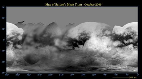
You've gotta be kidding. This is what all the fuss was about?
Boy, Alex is underwhelmed.
I'm glad to see it. I do find some of the seams surprising since they are "texture" seams, with shading captured pretty well. It seems like sometimes limited resolution was rendered hazily and sometimes it was rendered with an almost half-tone-looking grainy -- but sharp -- quality.
We're basically four good flybys away from bringing most of the "Here There Be Dragons" areas up to the standard of the rest of it: Two over Senkyo and Belet and two over the northern areas when the extended mission puts them into daylight.
Now let's add a splash of VIMS color and see if there's a graceful way to use RADAR data to sharpen up portions of the map without miscasting the RADAR data as being equivalent to IR (which it isn't).
I'm happy to have it, too.
-John Sheff
Cambridge, MA
-John Sheff
Cambridge, MA
This is a "lo-fi" version of our main content. To view the full version with more information, formatting and images, please click here.