Help - Search - Members - Calendar
Full Version: Colorized Context Camera Images
Unmanned Spaceflight.com > Mars & Missions > Orbiters > MRO 2005
Nirgal
After having discovered the proper calibration process for the black&white CTX images (thanks again
to slinted, cartrite and others for the valuable contributions !) I found that many of the cleaned up CTX images with the increased dynmiac range are
very well suited candidates for artificial colorization. Here are the first results:

A martian polar dust storm over ice dunes


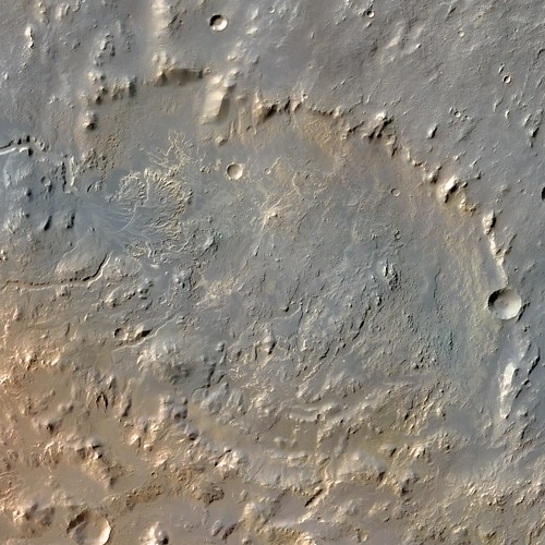
and a crater landscape with central mountains:


Please keep in mind that, as always with artificial colorization, the colors, although I usually do base the palettes on "real" color images of similar areas with similar surface composition, are, of course not intended to reflect the "true colors" but rather be understood as a kind of "artitst impression"

Stu
Lost for words, truly... ohmy.gif ohmy.gif ohmy.gif
slinted
Absolutely gorgeous Nirgal! Great picks, and colors!
ngunn
I'm enjoying these too, but I expected the dust clouds to look yellower, relative to the surface. Have I been looking at too many Chesley Bonestell paintings?
tedstryk
Simply amazing!
n1ckdrake
Outstanding work Nirgal! Thanks for posting these!
Nirgal
Here are another two of my favourite CTX images found at the great Mars Global Data Image Archive, calibrated and colorized:


P01_001473_1426_XN_37S169W

P02_001628_2652_XI_85N123W

smile.gif


ElkGroveDan
Those are beautiful. Good to have you back at it Bernhard.
mhoward
That second one in particular is just insane... should really be in a gallery.
Shaka
ohmy.gif ... blink.gif... biggrin.gif
machi
Dokka crater from CTX camera (NASA/JPL-Caltech/MSSS). Color is from MEX' HRSC images (ESA/DLR/FU Berlin).

Second image is again from CTX and colorised from HRSC images.
This crater is lowest place on Mars (if it is referenced to the areoid).

Color is more or less artistic impression, partly because of completely different light condition in first image (low sun (CTX) vs. high sun (HRSC)) and massive haze in second case (after all it is place with highest atmospheric pressure). Resolution is reduced to ~13 m/pix (resulting images had higher dynamic range and after adjustments much higher contrast).
Both images are part of my blog entry about lowest and highest places on Mars.
jccwrt
Here is a large CTX mosaic of Eberswalde Crater colorized using HRSC data. Please note that this isn't full CTX resolution - I needed to downsize it to 80% (~7 m/px scale) to fit the uncompressed image on Flickr.


Eberswalde Crater
wildespace

Full inline quote removed- Admin

That's an impressive lookig delta, very similar to the one in Jezero crater.
machi
QUOTE (jccwrt @ Dec 6 2018, 04:42 AM) *
Here is a large CTX mosaic of Eberswalde Crater colorized using HRSC data. Please note that this isn't full CTX resolution - I needed to downsize it to 80% (~7 m/px scale) to fit the uncompressed image on Flickr.


Great work!
BTW, there is a limit for Flickr?
I know that they changed limit for free accounts to 1000 images recently but for size I don't think that there is a limit.
I uploaded and downloaded my 24000×20300 pixels map without any problems.

QUOTE (wildespace @ Jan 5 2019, 10:29 AM) *
That's an impressive lookig delta, very similar to the one in Jezero crater.


That's the reason why it was candidate landing site for both Curiosity and Mars 2020 rover.
jccwrt
QUOTE (wildespace @ Jan 5 2019, 03:29 AM) *
That's an impressive lookig delta, very similar to the one in Jezero crater.


Yep - probably the main reason it lost ground to Jezero in the 2020 selection process was the orbital detection of carbonates at Jezero. In terms of geology they're otherwise very similar.

QUOTE (machi @ Jan 12 2019, 09:23 AM) *
Great work!
BTW, there is a limit for Flickr?
I know that they changed limit for free accounts to 1000 images recently but for size I don't think that there is a limit.
I uploaded and downloaded my 24000×20300 pixels map without any problems.


I'm not sure about pixel size limits, but there is a 150 or 200 mb size limit. I just made the decision to downscale rather than go with a lossy format.
jccwrt
So jumping off from my project to figure out ChemCam plasma colors from LIBS spectra, I realized that the code I developed could be applied to convert CRISM spectra and I could make true-color/natural-color/false-color stretches of my choosing. The products I am currently creating from the Map-Projected Reduced Targeted Data Records are very similar to those produced by the team, although I think going this route saves me from needing to use a work copy of ENVI to use the data like I have in the past. The technique I am using is probably only a minor improvement on the official CRISM processing is in terms of reduced color noise, since this can incorporate every spectral channel into a product, rather than relying on a median value of 5 channels to create a channel for an RGB composite.

The raw output is a little boring (it's a more or less butterscotch/orange color) so I'm going the route of producing either enhanced true color products (each channel individually stretched, similar to the the TRU browse product produced by the CRISM team), or enhanced natural color products (where each channel is individually stretched, and the brightness of each color channel adjusted to match the color of Mars dust). Some examples

Enhanced natural color

Layered Deposits in Southwest Candor Chasma - Mars Reconnaissance Orbiter

Enhanced true color (similar to CRISM TRU product)

Layered Deposits in Southwest Candor Chasma - Mars Reconnaissance Orbiter

Infrared false color (800 nm to 2000 nm)

Layered Deposits in Southwest Candor Chasma - Mars Reconnaissance Orbiter


A couple of additional sites:


Columbia Hills - Mars Reconnaissance Orbiter


Chasma Boreale - Mars Reconnaissance Orbiter
Steve G
Amazing work! I just finished colourising almost 400 family pictures from the 1950s. It's an art and work of love.
titanicrivers
While not colorized this MRO CTX image https://www.jpl.nasa.gov/news/nasas-mro-fin...viously-thought and article in AGU Advances https://agupubs.onlinelibrary.wiley.com/doi...29/2021AV000534 provides interesting evidence that Mars may have had “surface waters forming chloride deposits continued through the Hesperian and into the Amazonian, making them among the latest-formed, large-scale deposits of water-related minerals on Mars.”
This is a "lo-fi" version of our main content. To view the full version with more information, formatting and images, please click here.
Invision Power Board © 2001-2024 Invision Power Services, Inc.