Hi,
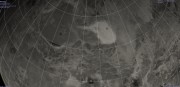
Can someone give me the current theory on how these landforms were made? I attached pic.
They look like maybe carved out of ground rock from a side shooting lava blob but I dont know.
These ones were found south of maxwell but I have seen them sometimes other spots.
I might think they are splatters of hot rock that carved out of the flat local area but I am really guessing.
Whats the official theory?
thanks
Full Version: What is the theory on formation of this landform?
What's the source image.
One possibility: Not splatters of rock on the surface, but more likely lava flowing under a hardened crust - the flows cover the surface, they begin to cool and harden, and the lava continues to flow under its card crust. Then in some places as the lava drains out the crust collapses into the voids.
Another possibility - extensive lava flows. Then a system of parallel fractures form, possibly over dykes (volcanic intrusions, lava pushing into the fractures). As the fractures open or the lava drains away (suggesting flows downhill from here) the surface collapses into the open fractures, creating pits and chains of coalescing pits, very much like those seen around Alba Patera on Mars - which might be a Martian version of a Venusian corona.
But it would be good to see more of the scene, to get geological context.
These features are common on Venus, not just found here.
Phil
fl63n358.img on cd mg_1115 directory fl66n348
QUOTE (ncc1701d @ Feb 23 2011, 10:21 PM) 
how these landforms were made?
No idea if there is an official theory, but I enjoy random questions like this. My first guess would be collapsed lava tubes. Flow rate and therefore diameter would depend on the local gradient. Where the gradient reduced enough the flows would widen and stop. Does the local gradient decrease from top left to bottom right across your image? If not I'm hopelessly wrong (which is very likely in any case).
I like the pit theory you talking about. The shape furthest right in new image I attached leads me to believe your parallel fracture drainage pit concept. Its is not thin on first half and wide on the other.
and I guess the others look thin on one end and thick on the opposite is becuase of them forming going down hill if I understand you right.
Any comparable structure like that happen on earth? perphaps even on a smaller scale if not large?
and I guess the others look thin on one end and thick on the opposite is becuase of them forming going down hill if I understand you right.
Any comparable structure like that happen on earth? perphaps even on a smaller scale if not large?
from the image "fl63n358.img"
Click to view attachment
so from the measurements
right to left
60 px = 4.5 Km
37px = 2.775 Km
and
76px= 5.7 Km
so they are fairly large also this is a "left look" radar so they are valleys ( not mounds)
collapsed lava tube ?
CODE
MAP_RESOLUTION = 1408.131<PIXEL/DEGREE>
MAP_SCALE = 0.075 <KM/PIXEL>
MAP_SCALE = 0.075 <KM/PIXEL>
Click to view attachment
so from the measurements
right to left
60 px = 4.5 Km
37px = 2.775 Km
and
76px= 5.7 Km
so they are fairly large also this is a "left look" radar so they are valleys ( not mounds)
collapsed lava tube ?
The discontinuations look like classic collapsing lava tubes.
would "classic" collapsed lava tubes be so rounded around the edges? I dont know.
I am just looking at pics of colapsed lavatubes on earth they dont seem so rounded but I am looking at ground level.
When I look at these or others I see on Venus they seem so lava or fluid like in their shapes. Any satellite photos of colapsed tubes on earth to compare?
I am just looking at pics of colapsed lavatubes on earth they dont seem so rounded but I am looking at ground level.
When I look at these or others I see on Venus they seem so lava or fluid like in their shapes. Any satellite photos of colapsed tubes on earth to compare?
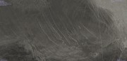
some context images


This is a "lo-fi" version of our main content. To view the full version with more information, formatting and images, please click here.