mhoward
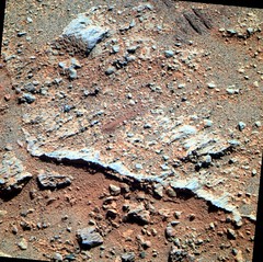
Dec 25 2011, 09:33 PM
A new foreground color stereo pair from sol 2814

walfy
Dec 27 2011, 06:30 AM
mhoward's recent excellent stereo pair was used for this nice one:
Click to view attachment
walfy
Dec 27 2011, 06:46 AM
Also from mhoward, sol 2010. Interesting how a wheel pushed the rock that plowed up a little soil. Some of the soil seems to have stuck to the rock. Wasn't this sticky soil behavior observed before? I thought I read about that at some point in the mission.
Click to view attachment
PDP8E
Dec 28 2011, 04:37 AM
Here is a recent image taken off the bowsprit of Oppy ...processed for detail.
Of the 4 major plates of rocks in the image, is that a gypsum vein above the northwest plate?
(... deploy the RAT brush ...)
Click to view attachment
Paolo
Dec 30 2011, 09:32 AM
from the latest mission update:
QUOTE
Opportunity will also begin a radio Doppler tracking campaign at the start of the new year.
what is this? are they trying to recover some of the Spirit "fixed lander" data? any info?
nprev
Dec 30 2011, 10:48 AM
I don't know, but if Oppy's going to stay put for a bit over the winter it seems logical to try to obtain similar data.
Not at all surprising, and in fact a smart use of resources.
jvandriel
Dec 30 2011, 11:30 AM
Color Pancam images from Sol 2817 and 2818 L257 and L456
stitched together.
Jan van Driel
Click to view attachment
mhoward
Dec 30 2011, 01:06 PM
QUOTE (Paolo @ Dec 30 2011, 03:32 AM)

what is this? are they trying to recover some of the Spirit "fixed lander" data? any info?
Yes; it was discussed in the
latest monthly rover update at planetary.org.QUOTE
"If Opportunity parks with a 15-degree tilt, we should be able to do some of the radio science," Arvidson said. "It's the most energy intensive activity we could do, so it will depend on what's happening with the dust factor and with the opacity. But our intent is to go in with the radio science experiment limited by energy. It really is the most important thing to do if we can afford the energy and having a good place where we can get a good southeasterly wind fetch."
"We will stay put for a while, for as short a time as we can and we will get as much radio science done as we can in the time that we stay put," said Squyres. "But as soon as we have enough power to boogie, we're going to boogie."
Bill Harris
Dec 30 2011, 11:41 PM
QUOTE (PDP8E @ Dec 27 2011, 10:37 PM)
Here is a recent image taken off the bowsprit of Oppy ...processed for detail.
Of the 4 major plates of rocks in the image, is that a gypsum vein above the northwest plate?
It's probably not Gypsum, probably it's just an ochre-colored zone that is coincidentally linear.
This rock is a good example of the reworked impactite I've mentioned. The large rock is is probably an earlier impact breccia which has been subsequently disturbed, fractured and cast by a later impact, and which was apparently covered by later ejecta or weathering detritus and tilted up by the Endeavour impact and exposed to erosion. It's had a full life...
Matt Lenda
Dec 31 2011, 10:52 PM
QUOTE (Paolo @ Dec 30 2011, 02:32 AM)
from the latest mission update:
what is this? are they trying to recover some of the Spirit "fixed lander" data? any info?
Extended HGA 2-way Doppler measurements to find out things about the interior structure of Mars. We would have done it with Spirit had she survived last winter. Need a few hours of data a week to be meaningful.
Man, I've been totally AWOL and I have no idea what's going on with Oppy! Tuesday morning will be interesting when I got back on that tactical horse...
-m
Bill Harris
Jan 1 2012, 11:26 AM
Good. I like blue and sparkley. Sky Flats (P2440) is a nice place to visit.
--Bill
PDP8E
Jan 2 2012, 02:24 AM
Here is an image off the front of OPPY on SOL 2819 , a little after 1:00pm local time.
Click to view attachment
jvandriel
Jan 2 2012, 01:36 PM
The Pancam L257 view on Sol 2820
stitched together.
Jan van Driel
Click to view attachment
mhoward
Jan 4 2012, 02:22 PM
Here's the first frame of the just-started Greeley Pan. L257R21 - ideal for color stereo. I'm very excited that eventually (presumably) we should have a whole 360º color stereo panorama from this location. If we must stand still for a while, at least maybe we'll get something in return for it.
kungpostyle
Jan 6 2012, 01:51 PM
Just made a 3D view which I think works pretty well, but too big to post here, so if you'd like to see it please wander over to my blog...
http://roadtoendeavour.files.wordpress.com/2012/01/3d3.jpgTrying to find a name given to that feature and failing miserably...
mhoward
Jan 6 2012, 05:49 PM
QUOTE (Stu @ Jan 6 2012, 08:30 AM)
Trying to find a name given to that feature and failing miserably...
"Bedrock Foreground"

Wow, they thought long and hard about
that one, eh..?

fredk
Jan 6 2012, 11:16 PM
A couple of notable comments from the latest
PS update:QUOTE
The radio science experiment will be the first priority, and the second priority will be Mössbauer data to get at the iron mineralogy of the Shoemaker Formation, and then the third priority is to get a beautiful Pancam panorama of Greeley Haven, said Arvidson. If it turns out that after 40-60 hours the Mössbauer data looks really neat then well probably continue the integration, go into the winter low time, and then come out the other side and get even more hours.
QUOTE
For each of the experiments in its winter science campaign, it's best if Opportunity stays parked in place, although the rover can move a little, up to a meter, Arvidson pointed out, as long as we track locations within centimeters using visual odometry."
PDP8E
Jan 7 2012, 05:12 AM
On SOL 2810 Oppy's right front wheel was imaged 9 times during what seems to be an engineering test.
This is an animation that goes forwards then backwards before repeating (is there a word for that?)
The left wheel, also imaged at the same time for 9 images, does not move (other than the shadows advancing).
Click to view attachment
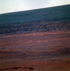
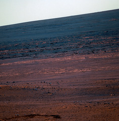
Artistic take on "Morris Hill"
Click to view attachment
Matt Lenda
Jan 8 2012, 02:24 AM
QUOTE (PDP8E @ Jan 6 2012, 09:12 PM)
On SOL 2810 Oppy's right front wheel was imaged 9 times during what seems to be an engineering test.
This is an animation that goes forwards then backwards before repeating (is there a word for that?)
The left wheel, also imaged at the same time for 9 images, does not move (other than the shadows advancing).
Yes, we had a drive "hiccup" where we stressed the right-front wheel too much and she faulted out. (Faulting out is a good thing, because it protects the hardware.)
On 2810, we sequenced an itsy-bitsy drive to test that we weren't in real trouble. Something like a 3cm drive, close to the smallest Oppy will allow. All is well even with that right-front wheel.
Cool gif! Love animations.
-m
marsophile
Jan 8 2012, 05:19 AM
http://www.lpi.usra.edu/meetings/marsmicro2009/pdf/9006.pdfhttp://www.lpi.usra.edu/meetings/marsmicro2009/pdf/9008.pdfThese abstracts suggest that the dust in dust devils on Mars is mostly raised by temperature gradients caused by rapid changes in illumination---not by wind per se.
If this is so, then Oppy might get some cleaning of the solar panels if it could somehow arrange for a shadow to pass over the deck! It's not clear how that could be achieved, though.
[EDIT: Another possibility is that rapid opening and closing of the miniTES cover while the sun is shining down the barrel might help to clear dust from the MTES by thermal effects such as the Knudsen Compression effect.]
algorimancer
Jan 10 2012, 07:49 PM
QUOTE (marsophile @ Jan 7 2012, 11:19 PM)
....opening and closing of the miniTES cover while the sun is shining down the barrel might help to clear dust from the MTES by thermal effects such as the Knudsen Compression effect.
That strikes me as a really promising notion -- replace external winds with internal convection. I don't know if the mechanical configuration of MiniTES is conducive to this, but it might be worth a try. This is one thing which may be much more economical to test empirically, rather than by simulation.
jamescanvin
Jan 10 2012, 11:10 PM
Morris Hill

James
DFinfrock
Jan 11 2012, 03:11 AM
QUOTE (Stu @ Jan 7 2012, 11:57 PM)
Artistic take on "Morris Hill"
Thanks for the new wallpaper Stu! Beautiful!
walfy
Jan 11 2012, 04:18 AM
A closeup from sol 2829:
Click to view attachment
Nirgal
Jan 11 2012, 05:25 PM
QUOTE (jamescanvin @ Jan 11 2012, 12:10 AM)
Morris Hill
James
Yet another one for the 'most scenic MER photos' gallery !
Congratulation, james
Stu
Jan 11 2012, 07:51 PM
(only) section (I've been able to stitch together properly) of the Greeley Panorama, looking north...
Click to view attachment
marsophile
Jan 11 2012, 08:01 PM
QUOTE (marsophile @ Jan 7 2012, 09:19 PM)
... arrange for a shadow to pass over the deck...
A rotation in place of the rover could cause a shadow of the mast to pass over the deck. The movement would be the most rapid in areas of the deck that are furthest from the mast.
If this were to be tested empirically, the well-delineated dark area near the sundial platform (at the rear of the rover) could be used as a test area to detect any motion of the dust on the deck resulting from the passage of the shadow.
Matt Lenda
Jan 12 2012, 03:24 AM
QUOTE (Stu @ Jan 11 2012, 11:51 AM)
(only) section (I've been able to stitch together properly) of the Greeley Panorama, looking north...
Click to view attachmentfyi, that's only nine parts of a twenty-something-part panorama... gonna be gorgeous.
-m
James Sorenson
Jan 12 2012, 04:13 AM
That was a rather large CR hit in the far right frame in Stu's pan.
Stu
Jan 12 2012, 07:38 PM
Looking north, down, and off, Cape York...
Click to view attachment
fredk
Jan 13 2012, 05:21 PM
This new frame from the big pan gives us our first (full frame) pancam view of the "notch" coming off the NE end of CY:
http://qt.exploratorium.edu/mars/opportuni...2M1.JPG?sol2833Only L2/R2 so far (and very little 3D effect at that distance) - it'll be cool to see this in colour once the L5/7 are down...
Floyd
Jan 13 2012, 07:45 PM
I would hope the mission explores the "notch" before we leave Cape York. Following the edge around CY would allow us to determine the frequency of gypsum veins and no doubt a few other interesting things...
Matt Lenda
Jan 14 2012, 02:08 AM
QUOTE (Floyd @ Jan 13 2012, 11:45 AM)
I would hope the mission explores the "notch" before we leave Cape York. Following the edge around CY would allow us to determine the frequency of gypsum veins and no doubt a few other interesting things...
Indeed. Give it until about... May of this year. We'll start boogeying. I don't know what the strategic plan is other than to go to the juicier bits to the south on the inboard side; who knows if we want to explore the northern apron or not. Would be great to see.
ElkGroveDan
Jan 14 2012, 03:15 AM
Regardless of what created that notch, I would expect it would be like like having a road-cut cross-section to examine. Surely the pointy-heads won't want to pass that opportunity up (NPI).
ngunn
Jan 14 2012, 11:23 AM
I'm not so sure that thinking of it as a notch (that is - something cut out) is helpful. Maybe we should think rather of its right hand side as an isolated spike of apron material and ask how that could have formed. Current thinking among the team seems to be that the apron consists of meridiani material altered by contact with groundwater with different chemistry originating from the ancient crater rim rocks. Could the influence of this groundwater extend a few metres farther out in one particular place to form a spike? Maybe, if the overdraped sediments cracked and slumped a little towards the centre of Endeavour and the noachian-flavoured groundwater exploited the crack. It seems to me that the orientation of the notch/spike roughly parallel to the crater rim is what you would expect for the alignment of a crack formed by downslope slumping.
MarkG
Jan 14 2012, 05:37 PM
The possibility exists that the notch is just a rim slump crack filled in (long ago) by sediment.
(or the scar from an errant laser blast in a long-ago interstellar conflict...)
PDP8E
Jan 14 2012, 06:18 PM
On 2820 the NAVCAM took a low angle shot of the notch/dagger
I straightened it up and stretched it 5x
Click to view attachmentMarkG: I like your thinking, but a laser blast might be a stretch, its probably something more mundane like
Storm Drain Outflow Pipe - No. 23
Stu
Jan 14 2012, 10:06 PM
Personally I really don't care that much at this point
what the geological explanation for "the Notch" is. Be it magnificent or mundane, I just want to
see it. Ever since I saw it for the first time, on the first HiRISE image of Cape York that I looked at with the IAS Viewer after the decision ws taken to head for Endeavour, this feature has called out to me. It just fascinates me. Oppy is a geologist, true, but she's also an explorer, and we're all - those of us that want to, anyway - walking alongside her as she explores this fascinating place just for the sake of exploration. I'm sure the MER team feel the same drive to peer around the next corner, and look over the horizon, just as we do.
We won't be this way again for a long, long time.
C'mon. Let's go look at cool stuff.
PDP8E
Jan 15 2012, 01:28 AM
QUOTE (Stu @ Jan 14 2012, 05:06 PM)
We won't be this way again for a long, long time.
C'mon. Let's go look at cool stuff.
I second that motion!
Let's see, Winter Solstice is March 30, 2012, so we can be mobile again by May 30th (?)
CosmicRocker
Jan 15 2012, 06:13 AM
I'd have to agree with everyone that the notch would be an exciting place to visit with the rover, but we should remain aware of the responsibility that the MER team bears as they control this rather expensive scientific instrument. As much as many of us would like to see them have some fun with the vehicle, sight-seeing has clearly not been a priority on this mission.
Any target is going to have to offer a scientific return...period. I'd have to agree that Oppy is an explorer as well as a scientist, and that serendipity has always had much to do with scientific discovery.
The notch is certainly the only road-cut cross-section around (as EGD has pointed out). It appears to me that the notch should provide a rather nice, 3D view of the lower stratigraphic section of the sediments draped over the Noachian crater rim, and that section of rocks which has been locally altered by paleo groundwater.
It should be intereting to see if they head north or south after the seasons change.

Bill Harris
Jan 15 2012, 12:34 PM
And I'll agree with CR that the notch would provide an excellent road cut to peer into the past, although some features may be covered by the "QAL" type of deposits. Another good roadcut would be that fresh-ish crater on the NW side of the winterhaven area, giving a view into the onlap on the Meridiani side, with convenient hand specimens.
But the actively-eroding Eastern face of CY, which will give a good section through the upturned pre-Endeavour strata, will also give an excellent science return for our plucky explorer. We'll see what she does come Spring Thaw.
--Bill
Stu
Jan 15 2012, 12:38 PM
Panorama taking shape nicely now... I'm not a skilled enough image mage to handle the job of combining everything in colour, I'll leave that to you James!
Instead, restricting myself to collecting and stitching L2s to make a sweeping bw panorama... too big to post here, so a link to my what-I've-got-so-far image on my blog:
http://roadtoendeavour.files.wordpress.com...2/01/jan-15.jpg
ngunn
Jan 15 2012, 02:09 PM
Very impressive already.
The clarity of detail visible across the crater is magnificent now. Fredk can probably read my 3D thoughts.
On the upturned pre-Endeavour strata Bill mentioned: I was expecting to see those on Morris Hill but instead everything there looks draped downslope, more like a Victoria bay than a Victoria cape.
CosmicRocker
Jan 16 2012, 05:15 AM
Yeah, these beds dipping into the crater have perplexed me for quite some time, now. We could even see them dipping off of Solander Point as Opportunity came around the south end of Cape York.
I have been mapping the dips of strata ever since we arrived at Cape York, expecting to see the upturned layers that were predicted from the HiRise imagery. I think we were seeing some westerly dips on the southern end of Cape York, but as we've come north on the cape, easterly dips have been more apparent. I'm not sure how to interpret these layers dipping into the crater, but my best guess is that they are rocks that are younger than Endeavour Crater. Perhaps they are the equivalent of the Burns Formation sulfate sands draped over the crater rim, or perhaps they are sediments eroded from the rim after it was uplifted.
These are questions that could be answered if Oppy could go back to investigate some of the outcrops she flew by on her rush to her winter haven. I'd sure like to get a closer look at those layers on Morris Hill.
MarkG
Jan 16 2012, 11:18 PM
Those beds could be actually almost-overturned --A folded over flap of layers. I'm not sure we have been able to see which way is up in the strata yet...
CosmicRocker
Jan 17 2012, 06:03 AM
It is certainly possible that the layers are overturned, and that is one reason why I would like to get a closer view of the rocks on Morris Hill. There are some hints of cross-lamination there which could point upward in the section, but it is really at the limit of the image resolution.
But I really have a hard time sketching a structure that includes such a tight fold, putting the easterly dipping rocks in such close proximity to the westerly dips we saw at the south end of Cape York. (see imagery from sols 2710-2735) Let's hope we eventually get some images that allow us to better elucidate the structure and stratigraphy here.
Bill Harris
Jan 17 2012, 10:23 AM
There is something odd going on here. The observed (assumed?) dips aren't matching up to what "oughtabe". We did rush to get here and all we have are passing glimpses at interesting structure. Not to mention, we don't know what the undisturbed (pre-Endeavour) strata was like (structurally or lithologically)-- remember, we're a skip-hop-and-a-jump from Miyamoto. And from a terrestrial standpoint, we have little experience with the giga-ton impact energies and large impacts this (relatively) well preserved.
I know that beds can be overturned by high-energy impacts but I wonder if the beds can also be crumpled? Tis a mystery.
In an ideal world, we'd have a drilling traverse with core samples and beaucoup seismic imagery to drool over. In this real world, we have to wait for more puzzle-pieces to drift by.
I hope Oppy makes it to the points south of CY.
--Bill
This is a "lo-fi" version of our main content. To view the full version with more information, formatting and images, please
click here.