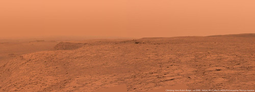
Full Version: The Top of Vera Rubin Ridge Part 2
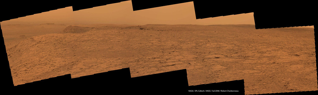
Sol 2098 Lmastcam:
QUOTE (Steve G @ Jul 2 2018, 03:37 PM) 
Have they abandoned plans to climb Mount Sharp? Based on the original timeline from when the mission landed, they're already about 4 years behind.
Climbing Mt. Sharp was never the goal of the mission, but a primary goal was the "Clay Trough" (https://www.hou.usra.edu/meetings/lpsc2017/pdf/2531.pdf). MSL is about to reach the this unit so stay tuned; it should be very interesting.
QUOTE (MahFL @ Jul 2 2018, 09:52 AM)
That was never really the plan, there is not much scientific reason to go up there.
Here was the original traverse going up the mountain, so it was part of the original plan.
That's not 'climb the mountain'. That's 'get to the sulfates'
And that remains the long term goal.
And that remains the long term goal.
"Here was the original traverse going up the mountain, so it was part of the original plan. "
That traverse is still what they want to do, though the exact path might vary. We are already well into that climb. It covers the lower slopes where the interesting geology is, and stops at the base of the upper mound. There is no expectation that Curiosity will climb higher up the mountain - it looks too rugged and is not expected to be of much geological interest. Any further exploration would remain in the lower part of the mountain.
Phil
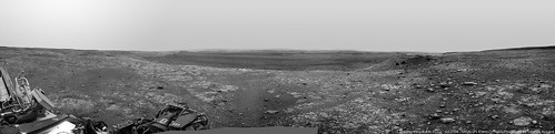
Panorama taken on sol 2098 with MC34, with an extended sky:
Nice panoramas!
I think the dust devil track I noted earlier has been joined by others (unless it's a heffalump). This shows a sector of the northern view on five recent sols. On 2089 there were no obvious tracks. On 2092 one can be seen (white arrows). No change on sol 2094. Then on 2095 two new ones show up, and no change on 2098. These are the first tracks observed on the ground at Gale, I believe. It will be interesting to see if any tracks show up in HiRISE images when it can see the area again. There are no obvious tracks in any previous HiRISE images of Gale.
Phil
Click to view attachment
QUOTE (Phil Stooke @ Jul 3 2018, 07:46 AM)
"Here was the original traverse going up the mountain, so it was part of the original plan. "
That traverse is still what they want to do, though the exact path might vary. We are already well into that climb. It covers the lower slopes where the interesting geology is, and stops at the base of the upper mound. There is no expectation that Curiosity will climb higher up the mountain - it looks too rugged and is not expected to be of much geological interest. Any further exploration would remain in the lower part of the mountain.
Phil
That traverse is still what they want to do, though the exact path might vary. We are already well into that climb. It covers the lower slopes where the interesting geology is, and stops at the base of the upper mound. There is no expectation that Curiosity will climb higher up the mountain - it looks too rugged and is not expected to be of much geological interest. Any further exploration would remain in the lower part of the mountain.
Phil
Thanks. Climb the mountain was perhaps the wrong term. But, how is the current progress compared to the original schedule? I thought we'd be in the canyon area within the prime mission.
You're right, progress has been slow. The terrain is rough and there are just too many interesting targets. I would not characterize it 'they are going too slowly', but as 'they didn't anticipate how much there was to look at along the way'. This is an amazing place.
Phil
Phil
I thought that was the case. I'm still sulking because they didn't check out the backshell, parachute and crash stage (I know it was a little toxic, but who doesn't like a crash site?)
Aw, don't sulk. Just remember that Curiosity is a robot geologist, not a tourist or crash site rubberneck.
I'm still hoping that she'll still be capable of reaching the 'Light-toned Unit' (LTU) via the 'Marker Bed' and other targets after she's wrapped up at the Sulfates. But right now I'd be happy with an updated 'Notional Path' to show what stops are planned on VRR and the exit ramp they hope to use for descending onto the 'Phyllosilicate Trough'. Wishful thinking on my behalf... I know, but one can always live in hope 
QUOTE (Phil Stooke @ Jul 4 2018, 04:42 AM)
....These are the first tracks observed on the ground at Gale, I believe. It will be interesting to see if any tracks show up in HiRISE images when it can see the area again. There are no obvious tracks in any previous HiRISE images of Gale.
Great spot Phil, be great to see them in future HiRISE sets...
Here is a short flight across the area discussed... starting on Vera Rubin Ridge and gliding up lower slopes of Mt Sharp
Superb detail evident in the 4k video of this dtm dataset...
4k version on Youtube
Superb detail evident in the 4k video of this dtm dataset...
4k version on Youtube
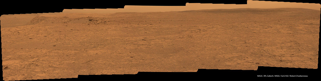
And another drive on Sol 2102, looking at the time stamps on Midnight Planets it appears to be about 50 minutes.
Click to view attachment
Click to view attachment
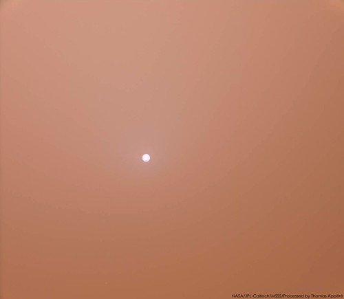
It's the first time I think Curiosity took a direct picture of the Sun without any filter.
A simple picture but I love it because it directly illustrates the global dust storm and its associated mood.
That's also likely what Oppy could see if it was still awake...
A simple picture but I love it because it directly illustrates the global dust storm and its associated mood.
That's also likely what Oppy could see if it was still awake...
QUOTE (neo56 @ Jul 6 2018, 07:36 AM)
It's the first time I think Curiosity took a direct picture of the Sun without any filter.
...except closer to sunrise/sunset, of course.
Here is a view we never see... the other side of Mount Sharp. From the southern plain of Gale Crater looking north. Curiosity sits way behind the left flank.

Made with HRSC, CTX & MARCI data
CTX heightmap supplied by Peter Grindrod & Joel Davis.
CTX texture source supplied by Tanya Harrison.
MARCI data supplied by Andy Britton.
Made with HRSC, CTX & MARCI data
CTX heightmap supplied by Peter Grindrod & Joel Davis.
CTX texture source supplied by Tanya Harrison.
MARCI data supplied by Andy Britton.
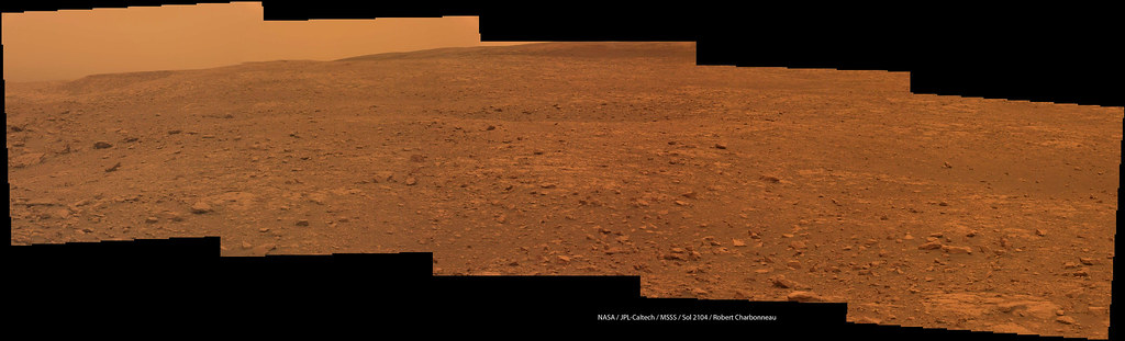
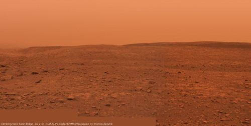
Sol 2104, what looks like a very long drive, (duration and distance) brings use back close to Taconite crater
Click to view attachment
Click to view attachment
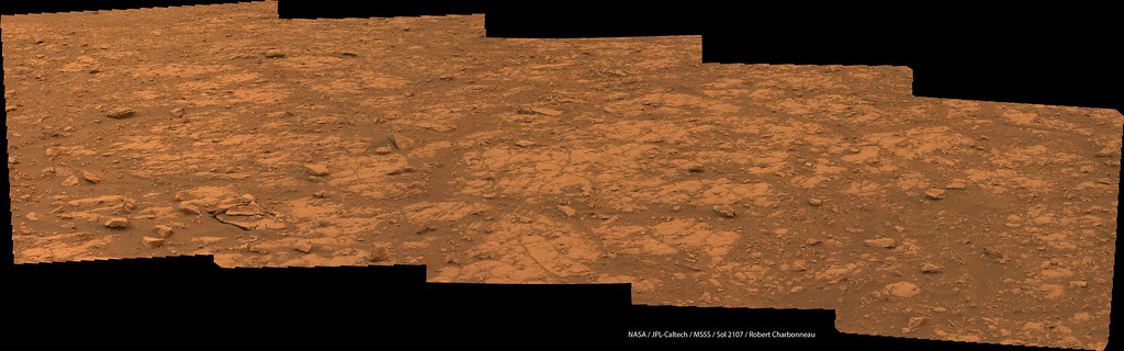
Sol 2102 post-drive Lmastcam:
And a look at the rocks nearby:
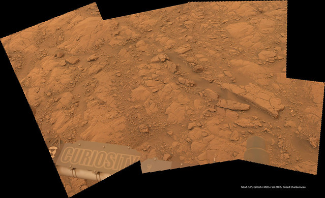
And a look at the rocks nearby:
Just wondering how this long drive relates to the drilling campaign in this important transition zone
QUOTE (monty python @ Jul 9 2018, 01:44 PM)
Just wondering how this long drive relates to the drilling campaign in this important transition zone
Thanks to Emily's most recent Curiosity blog (linked below) we now understand that "The team now plans as many as three more drill stops in the near future, up on top of Vera Rubin ridge." Phil's maps shows the remaining VRR geological members that the team identified at a conference. A post here recently also speculated that one of the previously visited Hematite 'hot spots' could also be on that list, maybe even the location were they tried to drill without hammer? I'm sure the mission updates in the coming days will give us a few clues to the location where the next sample site will be.
EDIT: I should have added that the mission update for 2100-01 told us that the next drill site was located on the "Pettegrove Point" geological member (see Phil's maps), so that appears to rule out Stop 13, as that's likely on the 'Jura member', so I'm going for 'Stop 12' as the next sample site. Note: those that follow my hunches will probably know that my track record on such predictions is nothing short of abysmal

Emily's Blog: http://www.planetary.org/blogs/emily-lakda...-2027-2092.html
Sol 2104 drive-direction Lmastcam:
And looking at the rocks nearby:
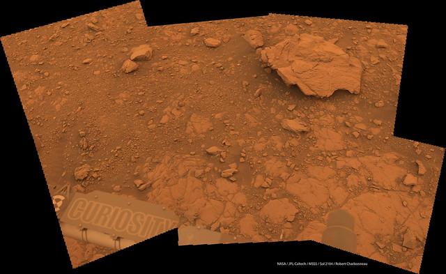
And looking at the rocks nearby:
Mosaics taken with MC34 and NavCam R on sol 2104, with extra-sky:
QUOTE (Phil Stooke @ Jul 11 2018, 07:42 AM)
Jan's sol 2104 panorama in circular format.
Nice work Jan, and nice to see Taconite again, as well as the slowly clearing vista of the plains in these great circular views
From the drive direction MastCam images it appears we may be heading a little further East or North-Northeast ? Edit: we now know that we're heading back to the location we worked at during sol 2005: https://mars.jpl.nasa.gov/msl/mission/mars-...ission-updates/
A shorter drive on sol 2108 to the next drill site.
Very impressed that some of the Duluth sample has remained on the engineering tray since they pulled away from the last drill location (sol 2108 pre-drive)
Click to view attachment
Very impressed that some of the Duluth sample has remained on the engineering tray since they pulled away from the last drill location
(sol 2108 pre-drive)Click to view attachment
Sol 2017 post-drive Lmastcam:
Jan's panorama in circular form. If you compare it with the same for sol 2004 we are in almost exactly the ame place, except that the two panoramas are facing in opposite directions, looking at the same foreground features (including Stranraer).
Phil
Click to view attachment
Phil
Click to view attachment
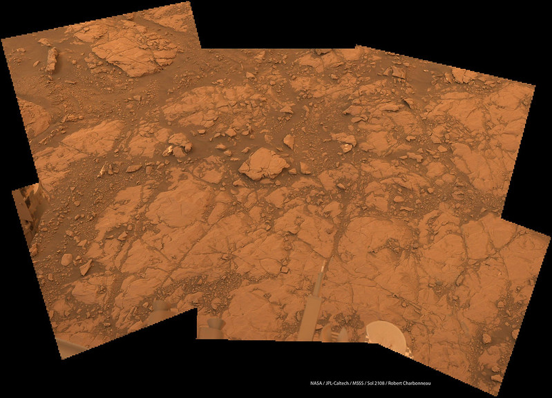
Sol 2108 Lmastcam:
Very nice, charborob. I took the liberty of using a reduced size version of it to show the location of the current target, and then made a new image showing how the old Stranraer target and the new Voyageurs target overlap.
Phil
Click to view attachment
Click to view attachment
Phil
Click to view attachment
Click to view attachment
QUOTE (Phil Stooke @ Jul 15 2018, 10:18 AM)
... and then made a new image showing how the old Stranraer target and the new Voyageurs target overlap.
Great detective work Phil
Sol 2112: the first images have arrived after the sample acquisition attempt at Voyageurs. The subdued lighting makes it hard to call either way, I'll have to await a mastcam frame to call it properly....
Click to view attachment
EDIT: 13 HazCam subframe data products are now down. I can't make an animation, but looking at all 13 frames I'd say that they were not fully successful on this attempt. It appears that they may have got the drill bit into the surface a very short amount, but probably not enough to have got a sample in the sleeve. There was plenty of sand movement, and what looks like several press attempts before they pulled the drill away. There may be more subframe images in the pipeline that tells another story, but from what I have seen they'll need another go, maybe with more hammer?
EDIT 2 : The Sol 2113 Mission Update, confirms the hole was not deep enough to obtain a sample: https://astrogeology.usgs.gov/news/astrogeo...-hard-as-a-rock
Sol 2113 ChemCam RMI of Voyageurs 'mini hole'
Click to view attachment
EDIT and the R-MastCam (mini hole) and the before image (DRT). We can see damage on the rock, probably caused by the hammer action. That's a tough rock!
Click to view attachment Click to view attachment
Click to view attachment
EDIT and the R-MastCam (mini hole) and the before image (DRT). We can see damage on the rock, probably caused by the hammer action. That's a tough rock!
Click to view attachment Click to view attachment
There seems to have been some significant vibration there. Were they trying percussion?
QUOTE (serpens @ Jul 18 2018, 06:56 AM)
There seems to have been some significant vibration there. Were they trying percussion?
Looks like it, Emily's last blog post discusses the return to using percussion with FED at Duluth, The animation from Jan suggests that they tried it here as well. Link to Emily's last blog http://www.planetary.org/blogs/emily-lakda...-2027-2092.html
Before & After Micro Images of a LIBS raster during sol 2114 at the shallow drill hole at Voyageurs.
Note the drill cuttings (tailings) were pushed away by the laser zaps. Is it probably just my wishful thinking, but the cuttings appear to bunched together and aligned by size at the rim of the hole. I was reminded of iron filings on a sheet of paper held above the pole of a magnet. Could this be an indication that the hematite-rich minerals at this hot spot are slightly magnetic?
Note also that the grain size appears to be larger than the previous powdered rock cuttings, maybe a result of the hardness of this rock.
In the post-LIBS image we can also see what appear to be a series of lines from the hole center to the rim, probably a result of the percussive action of the drill?
The sample acquisition may have failed, but it looks like they could have learned much from this campaign.
Click to view attachment Click to view attachment
QUOTE (PaulH51 @ Jul 19 2018, 09:39 AM)
Is it probably just my wishful thinking, but the cuttings appear to bunched together and aligned by size at the rim of the hole. I was reminded of iron filings on a sheet of paper held above the pole of a magnet. Could this be an indication that the hematite-rich minerals at this hot spot are slightly magnetic?
If there would be a significant overall magnetic field, and the grains would consist partially of magnetite, the particles would probably line up parallel to magnetic field lines. I don't perceive such an effect here. But slightly magnetic particles might clot together in a more random fashion.
Here, I'm inclined to presume, that the pattern the tailings are forming after the LIBS shots are just a result of the wind pressure decreasing with distance from the LIBS hits, maybe combined with the slope of the abraded area, and surface roughness, but without obvious evidence of magentism being involved.
Compositionally, this would suggest absence of magnetite that might have been magnetized by friction. But the color, of course, suggests presence of hematite.
And the hardness of the rock could explain why there is a ridge.
It would be interesting to know, whether the hematite itself is the cause of the hardness, or if it just plays the role of a pigment, and the hardness is caused by another mineral, like e.g. quartz. But APXS should be able to provide constraints, even if the drill powder isn't accessible for CheMin.
QUOTE (Gerald @ Jul 20 2018, 01:35 AM)
If there would be a significant overall magnetic field, and the grains would consist partially of magnetite, the particles would probably line up parallel to magnetic field lines. I don't perceive such an effect here. But slightly magnetic particles might clot together in a more random fashion.
Here, I'm inclined to presume, that the pattern the tailings are forming after the LIBS shots are just a result of the wind pressure decreasing with distance from the LIBS hits, maybe combined with the slope of the abraded area, and surface roughness, but without obvious evidence of magentism being involved.
Compositionally, this would suggest absence of magnetite that might have been magnetized by friction. But the color, of course, suggests presence of hematite.
And the hardness of the rock could explain why there is a ridge.
It would be interesting to know, whether the hematite itself is the cause of the hardness, or if it just plays the role of a pigment, and the hardness is caused by another mineral, like e.g. quartz. But APXS should be able to provide constraints, even if the drill powder isn't accessible for CheMin.
Thank you Gerald, I appreciate your insight once again
Click to view attachment
If the static electro force is great enough to generate a magnetic field the color of the drill area would be that of atmospheric dust proportionally.
If the static electro force is great enough to generate a magnetic field the color of the drill area would be that of atmospheric dust proportionally.
This is a "lo-fi" version of our main content. To view the full version with more information, formatting and images, please click here.