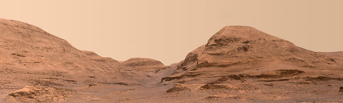
Sol 3030 Rmastcam:
Click to view attachment
Full Version: Atop/Around the Greenheugh Pediment
Zooming on this wonderful landscape, sol 3030, MCR.
Clouds over Gale crater.
fredk here is the Animation taken on Sol 3030 with the R Navcam.
Jan van Driel
Click to view attachment
fredk here is the Animation taken on Sol 3030 with the R Navcam.
Jan van Driel
Click to view attachment
Here is a travel sequence recorded with MARDI - Sol 3032.
https://flic.kr/p/2kCqxpS
Click to view attachment
https://flic.kr/p/2kCqxpS
Click to view attachment
A sol 3036 3D cross-eyed view of a nearby hill (does it have a name?):
Click to view attachment
And a wider view:
Click to view attachment
Click to view attachment
And a wider view:
Click to view attachment
Jan's panorama for sol 3036 in circular form. We are cruising around that patch of dark drifts on the way to the bright outcrop.
Phil
Click to view attachment
Phil
Click to view attachment
QUOTE (jvandriel @ Feb 22 2021, 05:14 AM) 
Sol 3036 Chemcam view.
The concave facets in the top of that outcrop are probably ventifacts caused by millennia of mountain winds whipping over the outcrop, but is there a very small chance they are surface features of a rather large, once buried meteorite that dropped into this landscape billions of years ago? Wishful thinking on my behalf I know, but one can dream
 I wonder if they did any passive spectroscopy with the ChemCam when they shot this sequence, if so they may take a closer look as they are driving ever closer on this excursion to the east.
Sol 3038: End of drive R-NavCam pan, very roughly stitched in MS-ICE, but it may help to work out the location.
Click to view attachment
Click to view attachment
QUOTE (PaulH51 @ Feb 22 2021, 12:04 PM)
The concave facets in the top of that outcrop are probably ventifacts caused by millennia of mountain winds whipping over the outcrop
Could they just be dust ripples?
I think you are right, Fredk.
Phil
Phil
Anaglyph of the hills combining navcams from sols 3035 and 3038:
Click to view attachment
Click to view attachment
Sol 3039 Lmastcam panorama:
Click to view attachment
(Too bad there's a litte piece missing of the hill on the right.)
Click to view attachment
(Too bad there's a litte piece missing of the hill on the right.)
Sol 3040 long-distance RMI:
Click to view attachment
Click to view attachment
The MASTCam L view on Sol 3039.
To complete the view of the top row of images,
I have added 1 MASTCam L image taken on Sol 3030.
Jan van Driel
Click to view attachment
To complete the view of the top row of images,
I have added 1 MASTCam L image taken on Sol 3030.
Jan van Driel
Click to view attachment
Sol 3040 Rmastcam view of Mont Mercou:
Click to view attachment
Click to view attachment
Sol 3039 Mastcam34 panoramic. Still impressed by how big those hills have become. They are more important than Mount Sharp.

Cloudy Sol on Mars:
Sol 3043 - There are more GIFs, but I just squeezed these 2 GIFs inside the upload limit. Looks like more thumbnails are in the system
The frames are unsharpened etc, just annotated and animated - R-NavCam frames with timestamps added curtesy of fredk.
The first one could be just post sunset, but I don't have the official sunset time.
Click to view attachment Click to view attachment
I really like these clouds animations. Here is a couple of 2 other animations.
Click to view attachment
Click to view attachment
Higher resolution versions here and here.
The sunset is at ~6:00pm local solar time. The last animation was made ~30 minutes after sunset!
The timelapse is 15 seconds between each frame for the first animation taken at 6:05 pm, 20 seconds for the 2nd one and 25 seconds for the 3rd one. It is not constant for the last one I processed.
I also noticed I dont obtain exactly the same local solar time as fredk (35 minutes shift). I use UTC time indicated on the Raws webpage and a code written during my PhDthat gives pretty similar results as Mars24. edit: I checked on Mars24 and my code indeed gives LTST shifted by 35 min in respect of Mars24 display.
Click to view attachment
Click to view attachment
Higher resolution versions here and here.
The sunset is at ~6:00pm local solar time. The last animation was made ~30 minutes after sunset!
The timelapse is 15 seconds between each frame for the first animation taken at 6:05 pm, 20 seconds for the 2nd one and 25 seconds for the 3rd one. It is not constant for the last one I processed.
I also noticed I dont obtain exactly the same local solar time as fredk (35 minutes shift). I use UTC time indicated on the Raws webpage and a code written during my PhD
The entire sequence ( ncam00598 ) started at 18:34:56 LMST and finished at 19:25:36 LMST
Sunset based on local topography was 18:23 LMST
Sunset based on local topography was 18:23 LMST
My LMST's agree with Doug's - I get them straight from the json files, when they're present - I don't calculate them.
Ok, so I'll have a look at my code 
Where do you find the JSON files?
Edit: my code returns LTST and not LMST. So I printed LMST and our values agree :-)
However, I wonder why Mars24 and JSON files refer to LMST rather than LTST?
Local True Solar Time takes into account the equation of time so it's more relevant isn't it?
Where do you find the JSON files?
Edit: my code returns LTST and not LMST. So I printed LMST and our values agree :-)
However, I wonder why Mars24 and JSON files refer to LMST rather than LTST?
Local True Solar Time takes into account the equation of time so it's more relevant isn't it?
Sol 3042 Lmastcam panorama:
Click to view attachment
Click to view attachment
QUOTE (neo56 @ Feb 27 2021, 11:50 PM)
However, I wonder why Mars24 and JSON files refer to LMST rather than LTST?
Local True Solar Time takes into account the equation of time so it's more relevant isn't it?
Local True Solar Time takes into account the equation of time so it's more relevant isn't it?
Yes, but LMST is easier to calculate and typically what's used for rover planning.
We have enough trouble keeping track of what happens when without having a variable length of day too!
QUOTE (mcaplinger @ Feb 28 2021, 07:05 PM)
Yes, but LMST is easier to calculate and typically what's used for rover planning.
We have enough trouble keeping track of what happens when without having a variable length of day too!
We have enough trouble keeping track of what happens when without having a variable length of day too!
Ok thanks! That makes sense.
QUOTE (neo56 @ Feb 27 2021, 11:50 PM)
However, I wonder why Mars24 and JSON files refer to LMST rather than LTST?
Local True Solar Time takes into account the equation of time so it's more relevant isn't it?
Local True Solar Time takes into account the equation of time so it's more relevant isn't it?
All rover activities are planned to LMST.
QUOTE (mcaplinger @ Feb 28 2021, 07:05 PM)
LMST is easier to calculate
Easier still would be standardized timezones. With increased presence on Mars perhaps one day we'll need one-hour-wide timezones.

Syrtis Major standard time, anyone?

QUOTE (fredk @ Feb 28 2021, 03:00 PM)
Easier still would be standardized timezones.
Maybe, but all we need now is one base time for sol 0 midnight at each lander.
For martian time zones, see See Arthur C. Clarke, "The Trouble with Time", anthologized in Tales From Ten Worlds.
Sol 3044 Lmastcam:
Click to view attachment
Click to view attachment
These are Jan's panoramas for sols 3042 and 3045 (end of drive... I will look at the mid-drive pan soon). Getting close to the brighter area and the cliff at Mont Mercou.
Phil
3042: Click to view attachment
3045: Click to view attachment
The JPL update mentions a drive on sol 3044 but it is a misprint for sol 3042.
Phil
3042: Click to view attachment
3045: Click to view attachment
The JPL update mentions a drive on sol 3044 but it is a misprint for sol 3042.
Clouds seen by the Right Navcam on Sol 3046.
Jan van Driel
Click to view attachment
Images credit: NASA / JPL-Caltech
Jan van Driel
Click to view attachment
Images credit: NASA / JPL-Caltech
MastCam thumbnails of some rather nice looking clouds on Sol 3047 should make a lovely mosaic
Click to view attachment
Click to view attachment
A color version of the clouds using overlapping frames as filters

Very nice cloud images and animations.
Here is Jan's panorama for sol 3047 in circular form. The bright ridges of rock on the east and west sides of the rover show up very clearly on the HiRISE image. Too bad the cliff itself got cut off.
Phil
Click to view attachment
Here is Jan's panorama for sol 3047 in circular form. The bright ridges of rock on the east and west sides of the rover show up very clearly on the HiRISE image. Too bad the cliff itself got cut off.
Phil
Click to view attachment
QUOTE (Phil Stooke @ Mar 4 2021, 01:00 PM)
Too bad the cliff itself got cut off.
It didn't.
https://mars.nasa.gov/resources/25676/n_r00...tolm2/?site=msl
Jan only uses Navcam left for his mosaics- and much of the time any upper-tier imaging we do is right eye only. It's why I had the script that generates the mosaics that go to https://mars.nasa.gov/msl/multimedia/mosaics swap from left eye to right eye - to catch upper tiers when we take them. Some are taken in stereo - but more often than not - right eye only
(Mono imaging has to be right eye as that camera's electronics box is monitored for temperature by the flight software for heating. Stereo imaging has to be within a window when heating isn't required anyway )
Looking at Eli's images above, they remind me of light refraction-type effects we get here on Earth -- relative to the Sun (and Moon).
Given that: I suppose that such refraction effects (halo's and dogs...etc.,) also occur in Mars's thin atmosphere during surface views for when the Sun is in the scene.
Have like phenomena been observed, and, perhaps, contributed to Mars's atmospheric data...in the long run?
John
Given that: I suppose that such refraction effects (halo's and dogs...etc.,) also occur in Mars's thin atmosphere during surface views for when the Sun is in the scene.
Have like phenomena been observed, and, perhaps, contributed to Mars's atmospheric data...in the long run?
John
Those colour cloud images are made by combining greyscale images taken at different times, so the cloud movement gives you artificial colour fringing.
I don't recall seeing sundogs or halos on Mars - perhaps someone else does?
I don't recall seeing sundogs or halos on Mars - perhaps someone else does?
This is a "lo-fi" version of our main content. To view the full version with more information, formatting and images, please click here.