Full Version: Radar And Mariner 10
[...]
QUOTE (Decepticon @ May 10 2005, 04:25 PM)
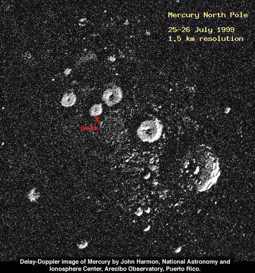
http://www.psrd.hawaii.edu/WebImg/HarmonRadarFig2.jpg
http://images.google.ca/imgres?imgurl=http...2005-12,GGLD:en

Awesome! Love the possiblity of ice in the polar craters - http://images.google.ca/imgres?imgurl=http...2005-12,GGLD:en
I guess it's only fitting to have water on Mercury, if we have mercury in our water here....

[...]
(Added detail: One of the major methodologies in high-resolution radar mapping produces an image which reflects details over a line which is near the equator, so the result is not a flawless hemispheric image, but an image which shows the north and south hemispheres ambiguously overlapped, so that you can say with confidence that each feature so detected is either in the northern OR southern hemisphere, but you can't be sure which! This ambiguity can be eliminated with repeat observations, with slightly changed geometry, which will cause the overlapping to happen at a different angle, revealing which hemisphere a feature is really in. I'm not sure if this final step has yet been performed, but the conference abstracts describing the work do not mention the ambiguity problem.)
I imagine that optical data could help - in other words, if there is a bright feature with rays extending from it in one hemisphere, and there is clearly a well defined, young looking (not overlapped by anything) impact crater in one hemisphere or the other, the optical data could help resolve the situation.
I imagine that optical data could help - in other words, if there is a bright feature with rays extending from it in one hemisphere, and there is clearly a well defined, young looking (not overlapped by anything) impact crater in one hemisphere or the other, the optical data could help resolve the situation.
[...]
I too am interested in this topic of pre-Messenger mapping of Mercury, in one of my many guises, as a historian of planetary cartography. One interesting aspect of cartographic history is the progression of mapping of a world from mission to mission... from pre-mission planning maps to the initial post-mission maps to assist initial data analysis, to the most advanced maps which summarize mission results, including relief, topography where appropriate, and geological maps. Mariner 10 didn't use a pre-mission map in the sense that Mars missions did, but there was a preliminary post-mission 1:25,000,000 scale map, and then the set of 1:5,000,000 scale quads and a new 1:15,000,000 global map. (and a lot more outside this very basic framework, such as the unpublished global map showing only the first encounter results).
Yes, I'd love to see a good pre-mission map. You are right, JRehling, it could be done. I'd love to see your work on this, actually. But one problem is that the radar data are almost always treated as traditional astronomical data, belonging to the scientists who obtained them, not as typical planetary data which are made public (almost immediately these days in some cases, and in compressed form). We planet types are spoiled! But the radar people have never released things very readily, one exception being the "pre-Magellan" CD-ROM with some venus and lunar radar data. An awful lot of radar data never even gets adequately published either.
Could your maps go up on a free image hosting service, with a URL in a post here?
Phil
[...]
The mercury maps are astonishing at this stage in the game! Terrific effort!
Can you post the link to the 8" amateur images?
Can you post the link to the 8" amateur images?
[...]
Thanks!
These are great images obtained from the ground. However, why couldn't the Hubble Space Telescope be used to image the non-Mariner side of Mercury? Hubble has resolved details on some of Juptier's moons (about the same size as Mercury) and Mercury is far closer to us.
QUOTE (Chmee @ May 17 2005, 08:43 AM)
These are great images obtained from the ground. However, why couldn't the Hubble Space Telescope be used to image the non-Mariner side of Mercury? Hubble has resolved details on some of Juptier's moons (about the same size as Mercury) and Mercury is far closer to us.
Mercury is too close to the sun to be safely imaged by the Hubble.
OUCH!
iirc - Hubble has a minimum sun angle which is can NOT go over - I dont think it's ever imaged Mercury simply because it's too close to the sun - and the damage that could be done is huge.
Doug
Doug
I wonder if the concern is the actual damage if Hubble observed Mercury, or the potential damage if Hubble accidently pointed directly at the Sun as it slewed to obseve Mercury.
The difference is that if Hubble will not be saved and it will be de-orbited, might it be worth the risk to have it obseve Mercury as it's last obsevation?

The difference is that if Hubble will not be saved and it will be de-orbited, might it be worth the risk to have it obseve Mercury as it's last obsevation?
[...]
A 'family portrait' of the Solar System by HST as it nears the end of it's operational lifetime would be very attractive, and a fitting companion to the Voyager 'Pale Blue Dot' sequence of images. Perhaps it could be justified as an engineering test, establishing a common baseline for all the available bodies it can see - not to mention a powerful bit of PR!
Erwin Van Der Velden's home page has moved. His pictures can now be viewed at:
http://www.erwinvandervelden.id.au/
http://www.erwinvandervelden.id.au/
QUOTE (gndonald @ Aug 15 2005, 04:26 PM)
Erwin Van Der Velden's home page has moved. His pictures can now be viewed at:
http://www.erwinvandervelden.id.au/
http://www.erwinvandervelden.id.au/
Wow! He's amazing - and with a C8!
QUOTE (Bob Shaw @ Aug 15 2005, 07:08 PM)
Wow! He's amazing - and with a C8!
Sadly, he passed away recently:
http://www.vereniging-astrofotografie.nl/n...en_english.html
I believe that 'Sky and Telescope' published a new mosaic of Mercury about 2 years
ago, utilizing Mariner 10 images. It shows the entire hemisphere of Mercury imaged
by Mariner 10 and was created by Mark Robinson of Northwestern, I believe.
However, can any one find that image on the Internet? I'm sorry, but I
do not recall which issue of 'Sky and Telescope' included that mosiac.
Another Phil
When Mariner 10 did it's second flyby, as it was near closest approach, it stepped it's filter wheel on one <?> camera though a sequence of filters, specifically including one wide-angle frame using the fiber-optic link to the "parasitic" wide angle camera lens and took a single wide-angle full disk view of the planet.
That shot (almost never reproduced) remains the single best view of albedo patterns on a semi-full gibbous disk view of Mercury. It looks like a horribly blotched mouldy grapefruit.
That shot (almost never reproduced) remains the single best view of albedo patterns on a semi-full gibbous disk view of Mercury. It looks like a horribly blotched mouldy grapefruit.
QUOTE (edstrick @ May 21 2006, 10:09 AM)
That shot (almost never reproduced) remains the single best view of albedo patterns on a semi-full gibbous disk view of Mercury. It looks like a horribly blotched mouldy grapefruit.
OK, you've done the 'tell' bit, now how about the 'show' part of your presentation! Your classmates are waitingggggggg!
Bob Shaw
QUOTE (PhilHorzempa @ May 19 2006, 10:04 PM)
I believe that 'Sky and Telescope' published a new mosaic of Mercury about 2 years
ago, utilizing Mariner 10 images. It shows the entire hemisphere of Mercury imaged
by Mariner 10 and was created by Mark Robinson of Northwestern, I believe.
However, can any one find that image on the Internet? I'm sorry, but I
do not recall which issue of 'Sky and Telescope' included that mosiac.
Another Phil
Maybe Mattias Malmer will take an interst in this. I think he's one of the best at compositing spacecraft imaging. There's a thread about his work here, and here is his directory of work: Malmer Images.
QUOTE (DonPMitchell @ May 21 2006, 05:06 PM)
Maybe Mattias Malmer will take an interst in this. I think he's one of the best at compositing spacecraft imaging. There's a thread about his work here, and here is his directory of work: Malmer Images.
That might be overstating things a little... but thank you very much

I make my living making 3D effects for commercials all day long... the ultimate in turdpolishing.
So I can cheat my way into making pretty pictures from source that are less than optimal...
I have been playing a little with the mariner 10 raw data and its actually pretty fantastic material. strange that we see so little of it displayed. The largest images of venus i have ever seen are in there. beautiful stuff.
Mattias
QUOTE (Malmer @ May 21 2006, 01:38 PM)
That might be overstating things a little... but thank you very much
I make my living making 3D effects for commercials all day long... the ultimate in turdpolishing.
So I can cheat my way into making pretty pictures from source that are less than optimal...
I have been playing a little with the mariner 10 raw data and its actually pretty fantastic material. strange that we see so little of it displayed. The largest images of venus i have ever seen are in there. beautiful stuff.
Mattias
Mariner-10 images are the best taken so far. Probably the height of vidicon tube technology before CCDs took over. There were a little over aggressive about bit rates, so the images are noisy, but some were sent at a reasonable rate.
The Pioneer Venus camera (if you can call it a camera) was not so great, but there is sure a mountain of images from it...somewhere. They have never been put online.
Let's hope Venus Express will be impressive. The VMC takes small pictures, but they are hoping to stitch together big panoramas. I'm sure over the next few years, the ESA will release a couple of them for us to see. :-)
You know, I got a book nearly 20 years ago that detailed the Mariner 10 mission, which included very nicely rendered airbrushed maps of the viewed portions of Mercury. It had a nice timeline in it which discussed events on Earth as they occurred during the Mariner 10 mission. (Unfortunately, the book was lost in a basement flood several years ago... *sigh*...)
It also had a very well-researched analysis of the Mariner 10 Mercury observations, including the terrain unit that you really don't see on the Moon -- the inter-crater plains. It seems very clear from the information wel already have about Mercury that the LHB didn't scar Mercury as badly as it scarred our own Moon. The population of large craters on Mercury is smaller than on the Moon, as witnessed by the fact that there are no places on the lunar surface where inter-crater plains still exist. On the Moon, the ancient crust has all been impacted at some point or another, with only a fairly minor exhibition of non-cratered mare surface here and there. The ancient crust of Mercury has been preserved without being marred by large cratering events in several places.
I can't wait to see what Messenger finds when it arrives...
-the other Doug
Mariner 10 and Voyager had very similar camera systems. Selenium Sulfide vidicon tubes, who's design went back to Mariner 69 and maybe some Mariner Mars 64 heritage.
Mariner 4 had a horrendous light leak -- PAST the shutter mechanism -- and impossibly limited data storage. Mariners 6 and 7 tried to solve the data storage problem with a combined analog/digital dual recorder system that *SORT OF* worked but was compromized by tape-crud contamination buildup on the analog recorder heads.
Mariner 9 upgraded to all digital, 9 bit (!) data and could stuff about 33 pics on a tape recorder load, doing 2 orbits a day and dumping 1 tape load just after a periapsis and the second just before the second periapsis (only one 210 foot DSN dish at the time). Unfortunately, the Mariner 69 and 71 data were badly corrupted by residual images. Approach images by Mariner 9 show multiple ghost imagtes of Mars in subsequent images in the sequence, slowly fading with each following shot.
Mariner 10 (and Viking orbiters, and Voyagers) used brilliant (literally) brute force engineering to eliminate the residual image problem. After each frame, they turned lightbulbs on INSIDE the cameras, then erased the light-flood staturated image so each image had an essentially perfectly repeatable residual image after erasure.
The noisy Mariner 10 data are from the Mercury flybys, where the range to Earth was right a the limit of the experimental 114,000 (or 148,000 or whatever then number was) bits / sec transmission rate. They traded off getting a LOT of salt-and-pepper speckled images at Mercury for fewer but clean images. The highest resolution images during the first flyby were tape recorded and played back later, the tape recorder failed before either the second (I think) or third flyby. DSN failure at the third flyby limited imaging to the central 1/4 or so of each frame due to a forced lower data rate, losing contiguous targeted high resolution mapping of selected targets <damn>.
oDoug:
Charles A Cross did an interesting mapping job on Mercury in the late 1970s - it'll be interesting to see if his work holds up. He published his maps (with Patrick Moore) but sadly then died.
Update:
Amazon have this book listed for £25 (there's a Mars volume too).
Hardcover 48 pages (August 1977)
Publisher: Mitchell Beazley
ISBN: 0855331151
Bob Shaw
Charles Cross did some interesting work. He let me copy some of his moon maps when I was a youngster just getting into the biz of planetary mapping many moons ago. - and he gave me a copy of the Mariner 6/7 map of Mars which is still one of my treasures. Then he did some Mariner 6/7 near-encounter mapping for the Rand Corporation, and then the Mercury and Mars atlases with Patrick Moore. Moore told me he had just completed Voyager mapping of the Galilean Satellites when he died. Those maps, which I would rent out an elderly relative to see, apparently disappeared into the archives of the BAA. Maybe somebody could find them...
Phil
Phil
I am a BAA member - give me some specifics and I'll try and get to the BAA library next time I'm down with my laptop+scanner
Dorp me an email with the Info phil, and I'll see what I can do.
Doug
Dorp me an email with the Info phil, and I'll see what I can do.
Doug
I'm sorry, Doug, I don't know any more than that. Cross made maps of the four Galilean satellites just before he died, and they apparently ended up at the BAA. You would have to see if they have his papers there. I think the maps were made for another atlas with Patrick Moore, but then were not used. Possibly they were not finished enough. After that, the quality of mapping in Moore's atlases went seriously downhill. I expect it was handed over to some graphics contractors who knew nothing about the subject.
He did great work, one of the few amateur cartographers who really became involved in planetary exploration, with his work for Rand on Mariners 6 and 7. A commemorative website devoted to his work would be a really nice resource.
Phil
He did great work, one of the few amateur cartographers who really became involved in planetary exploration, with his work for Rand on Mariners 6 and 7. A commemorative website devoted to his work would be a really nice resource.
Phil
QUOTE (tedstryk @ May 20 2006, 12:40 PM)
Thank you for this link. There is one mosaic, from the link above,
from Mariner 10's second encounter with Mercury,
that is close to what was in Sky and Telecope, namely this one.
Click to view attachment
However, as noted on the website, the gores in this image were to be filled in
using images from the 1st and 3rd Mercury encounter. I believe that that was the
mosiac that I saw in S and T. Does anyone have access to that image?
I really liked it as it showed the entire hemisphere of Mercury, that was imaged
by Mariner 10, in one view.
Another Phil
Do you have the ISIS calibration data for the Mariner-10 camera? Find the isisdist machine, where ever it is at the moment (the URL I used doesn't work now...welcome to NASA's churning domain names!). If you find it, look in isis/apps/mariner10. There are dark-current images, blemish maps and such.
Drop me an email if you want the FORTRAN code for linearizing the images. The calibration data is 260 MBytes, so try to find that online.
Drop me an email if you want the FORTRAN code for linearizing the images. The calibration data is 260 MBytes, so try to find that online.
QUOTE (Malmer @ May 21 2006, 04:38 PM)
That might be overstating things a little... but thank you very much
I make my living making 3D effects for commercials all day long... the ultimate in turdpolishing.
So I can cheat my way into making pretty pictures from source that are less than optimal...
I have been playing a little with the mariner 10 raw data and its actually pretty fantastic material. strange that we see so little of it displayed. The largest images of venus i have ever seen are in there. beautiful stuff.
Mattias
I make my living making 3D effects for commercials all day long... the ultimate in turdpolishing.
So I can cheat my way into making pretty pictures from source that are less than optimal...
I have been playing a little with the mariner 10 raw data and its actually pretty fantastic material. strange that we see so little of it displayed. The largest images of venus i have ever seen are in there. beautiful stuff.
Mattias
Here is the link to Malmer's "Big Io" image. It is truly one of the most
beautiful space images that I have ever seen. I congratulate you on some
excellent work.
http://syndicate.se/image/space/io_big.jpg
I do have a few questions. What is the source of the Io image? Did you
process one Galileo image of Io or is this a mosaic? Also, do you know
the date that the images were taken?
Another Phil
Outstanding new Arecibo radar images of equatorial and mid latitudes discussed here:
http://www.sciencedirect.com/science?_ob=M...=/sdarticle.pdf
P
http://www.sciencedirect.com/science?_ob=M...=/sdarticle.pdf
P
Yes, that is an excellent article.
Phil
Phil
Too bad it would cost me $30USD to take a look at it... 
-the other Doug
-the other Doug
I always wanted some good full disk coverage of Mercury. And I thank the person who put up the link to article for a free view!
That would be the first author, John Harmon.
This map is a composite of the USGS shaded relief and various radar images. The poles are reprojected from published images of the polar ice patches. The equatorial parts of the side not seen by Mariner 10 are from the new Icarus paper, but here these images have been specially processed to reduce the effects of the strong north-south ambiguity in all these images. That was not done in the new paper. Areas not covered may still be reprocessed in this way, but I'm not sure how well they can be done.
Phil
Click to view attachment
Phil
Click to view attachment
While reading this thread I realized I made the cylindrical map at http://www.lpl.arizona.edu/~rhill/alpo/mer...f/messenger.pdf, so here is my version of Phil's map.
Mucho, mucho gracias for the maps, Phil and Tayfun. To borrow a phrase... fascinating!
-the other Doug
-the other Doug
I have updated my composite map of Mercury, adding a few extra bits from remaining radar images from the paper cited earlier. Wherever possible I have merged at least two overlapping images with different radar equators to reduce the north-south ambiguity. This is probably as good as it's going to get before Messenger arrives, unless new radar images suddenly appear.
Phil
Click to view attachment
This is the northern hemisphere:
Click to view attachment
Phil
Phil
Click to view attachment
This is the northern hemisphere:
Click to view attachment
Phil
This is a "lo-fi" version of our main content. To view the full version with more information, formatting and images, please click here.