Updated Titan Map |

  |
Updated Titan Map |
 Oct 16 2007, 04:21 PM Oct 16 2007, 04:21 PM
Post
#121
|
|
 Senior Member  Group: Moderator Posts: 2785 Joined: 10-November 06 From: Pasadena, CA Member No.: 1345 |
Wow! Thanks, Phil!
That really fills in the northern terra incognita in the cylindrical projection! Nice to see it all being realized. -Mike -------------------- Some higher resolution images available at my photostream: http://www.flickr.com/photos/31678681@N07/
|
 |
 
|
|
Oct 16 2007, 04:27 PM
Post
#122
|
|
|
Member Group: Members Posts: 813 Joined: 29-December 05 From: NE Oh, USA Member No.: 627 |
Fantastic Phil....
Craig |
|
|
|
|
Oct 16 2007, 04:37 PM
Post
#123
|
|
|
Junior Member Group: Members Posts: 64 Joined: 11-October 05 Member No.: 525 |
Phil, it's really fantastic
 Thank you very much. Thank you very much.
|
|
|
|
|
Oct 16 2007, 05:16 PM
Post
#124
|
||
|
Senior Member Group: Moderator Posts: 2785 Joined: 10-November 06 From: Pasadena, CA Member No.: 1345 |
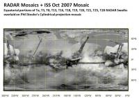
Hokay.... I tried to add the equatorial RADAR pieces over Phil Stooke's latest map to give a big RADAR composite on top of ISS images:
It sorta lines up, except in the mid-latitudes of the equatorial pieces (my fault, I have no idea how to warp and adapt the equatorial swaths to cylindrical projection in the higher latitudes.) At least it might help some future mapping goo-roo line it all up for real. (Phil? ExploitCorporations? Scalbers? Somebody heeeelp?) -Mike -------------------- Some higher resolution images available at my photostream: http://www.flickr.com/photos/31678681@N07/
|
|
|
|
|
|
|
Oct 16 2007, 05:58 PM
Post
#125
|
|
 Member Group: Members Posts: 809 Joined: 11-March 04 Member No.: 56 |
I'd love to see Phil's map in a proper Mercator projection -- those northern lakes would look HUGE.

|
|
|
|
|
Oct 16 2007, 10:29 PM
Post
#126
|
||
 Senior Member Group: Moderator Posts: 3233 Joined: 11-February 04 From: Tucson, AZ Member No.: 23 |
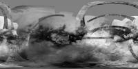
Here is the simple cylindrical map with reprojected versions of all the SAR swaths between Ta and T21 except the HiSAR stuff and T18 (will try to add that soon):
Attached thumbnail(s)
-------------------- &@^^!% Jim! I'm a geologist, not a physicist!
The Gish Bar Times - A Blog all about Jupiter's Moon Io |
|
|
|
|
|
|
Oct 16 2007, 10:38 PM
Post
#127
|
|
|
Senior Member Group: Moderator Posts: 2785 Joined: 10-November 06 From: Pasadena, CA Member No.: 1345 |
Beautiful!
Thanks, VP! -Mike -------------------- Some higher resolution images available at my photostream: http://www.flickr.com/photos/31678681@N07/
|
|
|
|
|
Oct 17 2007, 04:22 AM
Post
#128
|
|
 Administrator Group: Admin Posts: 5172 Joined: 4-August 05 From: Pasadena, CA, USA, Earth Member No.: 454 |
You're the man, VP.
--Emily -------------------- My website - My Patreon - @elakdawalla on Twitter - Please support unmannedspaceflight.com by donating here.
|
|
|
|
|
Oct 17 2007, 01:11 PM
Post
#129
|
|
|
Member Group: Members Posts: 813 Joined: 29-December 05 From: NE Oh, USA Member No.: 627 |
Thanks VP!!!!
Is this release of the ISS Titan map part of your work? I was just using this map to enlighten an office mate!!!!! Exploring a world by investigating the different equatorial albedo regions. Then the serendipty of the north polar passes (I know that main reason was to crank the inclination for CASSINI). Soon we will have more RADAR over the south pole. Those radar noodles across the surface and the refined imaging data really serve to illustrate that method. Fuzzy features slowly come into focus. The slow pealing away of mystery to reveal details with even more mystery. Neat thing would be to have a movie showing the early Keck maps and then slowly overlaying the different CASSINI map versions (including each RADAR noodle as it occurred) until we see the current state. That would be a neat educational tool. Any of you image gurus game for that? Thanks to the CASINI team and all you UMSF folks!!!!! Just Glorious!!!! Craig |
|
|
|
|
Oct 17 2007, 06:01 PM
Post
#130
|
||
|
Solar System Cartographer Group: Members Posts: 10153 Joined: 5-April 05 From: Canada Member No.: 227 |
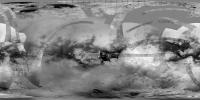
... and another version. Here I've taken VP's latest map and combined it with mine to link the radar strips. Then I did a bit of contrast modification. Less compressed, for ugordan.
Phil
-------------------- ... because the Solar System ain't gonna map itself.
Also to be found posting similar content on https://mastodon.social/@PhilStooke Maps for download (free PD: https://upload.wikimedia.org/wikipedia/comm...Cartography.pdf NOTE: everything created by me which I post on UMSF is considered to be in the public domain (NOT CC, public domain) |
|
|
|
|
|
|
Oct 17 2007, 06:24 PM
Post
#131
|
|
 Senior Member Group: Members Posts: 3648 Joined: 1-October 05 From: Croatia Member No.: 523 |
Outstanding, thanks a lot Phil. That's a keeper!
-------------------- |
|
|
|
|
Oct 17 2007, 11:37 PM
Post
#132
|
||
 Member Group: Members Posts: 610 Joined: 23-February 07 From: Occasionally in Columbia, MD Member No.: 1764 |
QUOTE (Phil Stooke @ Oct 17 2007, 02:01 PM)  ... and another version. Here I've taken VP's latest map and combined it with mine to link the radar strips. Then I did a bit of contrast modification. Less compressed, for ugordan. Phil
Nice map I'd love to see the movie someone described of morphing HST-Keck-etc-Cassini as our knowledge improves. Could even start with the two-spot model fit to the near-IR lightcurve in the early 90s I notice on this map at the extreme left, just above the bunny rabbit, some vaguely N-S striations (dunes) that I hadnt seen before and seem to be orthogonal to the more typical orientation. Are these real or are they some sort of ISS artifact ? |
|
|
|
|
|
|
Oct 18 2007, 01:33 AM
Post
#133
|
|
|
Solar System Cartographer Group: Members Posts: 10153 Joined: 5-April 05 From: Canada Member No.: 227 |
"I notice on this map at the extreme left, just above the bunny rabbit, some vaguely
N-S striations (dunes) that I hadnt seen before and seem to be orthogonal to the more typical orientation. Are these real or are they some sort of ISS artifact ?" Heh heh! Good one, Ralph... Phil -------------------- ... because the Solar System ain't gonna map itself.
Also to be found posting similar content on https://mastodon.social/@PhilStooke Maps for download (free PD: https://upload.wikimedia.org/wikipedia/comm...Cartography.pdf NOTE: everything created by me which I post on UMSF is considered to be in the public domain (NOT CC, public domain) |
|
|
|
|
Oct 18 2007, 06:38 AM
Post
#134
|
|
|
Member Group: Members Posts: 809 Joined: 11-March 04 Member No.: 56 |
QUOTE (Phil Stooke @ Oct 18 2007, 01:33 AM) "I notice on this map at the extreme left, just above the bunny rabbit, some vaguely N-S striations (dunes) that I hadnt seen before and seem to be orthogonal to the more typical orientation. Are these real or are they some sort of ISS artifact ?" Heh heh! Good one, Ralph... Er... isn't he being serious? I certainly think I see what he's talking about (including the "bunny rabbit", a bright two-eared formation that seems to be jogging along briskly to the west.) There's a rather large north-south dune field surrounding the Martha's Vineyard-shaped island with the big crater up around Tisbury. Doubtless I'm being dense and not seeing the joke -- unless this is just an in-joke between Ralph and Phil, in which case I won't be embarrassed. |
|
|
|
|
Oct 18 2007, 05:00 PM
Post
#135
|
|
|
Member Group: Members Posts: 610 Joined: 23-February 07 From: Occasionally in Columbia, MD Member No.: 1764 |
QUOTE (David @ Oct 18 2007, 02:38 AM) Er... isn't he being serious? I certainly think I see what he's talking about (including the "bunny rabbit", a bright two-eared formation that seems to be jogging along briskly to the west.) There's a rather large north-south dune field surrounding the Martha's Vineyard-shaped island with the big crater up around Tisbury. Doubtless I'm being dense and not seeing the joke -- unless this is just an in-joke between Ralph and Phil, in which case I won't be embarrassed. I think Phil is picking up on my possibly unfair skepticism : if it's not Scottish, it's crap. Same for RADAR. Ralphocentric view is - orientation of features is contrary to expectation , could it be an artifact? If so, it is then an ISS artifact. If it is real, it would be very interesting. |
|
|
|
|

|
Lo-Fi Version | Time is now: 27th April 2024 - 06:26 PM |
|
RULES AND GUIDELINES Please read the Forum Rules and Guidelines before posting. IMAGE COPYRIGHT |
OPINIONS AND MODERATION Opinions expressed on UnmannedSpaceflight.com are those of the individual posters and do not necessarily reflect the opinions of UnmannedSpaceflight.com or The Planetary Society. The all-volunteer UnmannedSpaceflight.com moderation team is wholly independent of The Planetary Society. The Planetary Society has no influence over decisions made by the UnmannedSpaceflight.com moderators. |
SUPPORT THE FORUM Unmannedspaceflight.com is funded by the Planetary Society. Please consider supporting our work and many other projects by donating to the Society or becoming a member. |
|