Landing Site Imagery |

  |
Landing Site Imagery |
 Apr 13 2008, 04:46 PM Apr 13 2008, 04:46 PM
Post
#121
|
|
|
Member  Group: Admin Posts: 468 Joined: 11-February 04 From: USA Member No.: 21 |
Yes, 13km further southeast puts the center of the ellipse right along the edge of the CTX coverage. I can't wait to see what you can put together Phil, since HiRISE is definitely going to be the best way to see it. Is it safe to assume anything about what 'southeast' means in this context? Since the old ellipse was northwest -> southeast, I'm wondering if this TCM just pushed the landing spot 13km further down the center-line of the old ellipse.
I've been working on improving the CTX mosaic nonetheless. This new one was done in ISIS, and improves on both the resolution and tone-matching compared to the one I previously posted. The scale on the full resolution version is 10 m/pixel.  Full Res (3.3 meg) The ellipse shown above is NOT the full 3-sigma ellipse, but rather the smaller 1-sigma ellipse (32 km x 6.5 km). I based the ellipse on a KMZ file made by Ross Beyer that contained the coordinates of the old, post-launch pre-TCM ellipses (available here) and shifted it 13km down-range (which may be a bad assumption). |
 |
 
|
|
Apr 13 2008, 10:44 PM
Post
#122
|
||
|
Solar System Cartographer Group: Members Posts: 10153 Joined: 5-April 05 From: Canada Member No.: 227 |
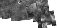
Here's a composite of slinted's new map and my latest HiRISE mosaic. Mine is uncontrolled - just matching features, and it's only very roughly fitted to the CTX map, just showing what we have for coverage. The 1 sigma ellipse is completely within the HiRISE coverage, as you might expect.
I think the ellipse is moved mostly along the axis. There isn't much room to push it sideways - not the 3 sigma ellipse, anyway. Phil
-------------------- ... because the Solar System ain't gonna map itself.
Also to be found posting similar content on https://mastodon.social/@PhilStooke Maps for download (free PD: https://upload.wikimedia.org/wikipedia/comm...Cartography.pdf NOTE: everything created by me which I post on UMSF is considered to be in the public domain (NOT CC, public domain) |
|
|
|
|
|
|
Apr 13 2008, 10:50 PM
Post
#123
|
||
|
Solar System Cartographer Group: Members Posts: 10153 Joined: 5-April 05 From: Canada Member No.: 227 |
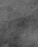
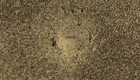
And this is the central part of the ellipse - not nearly as bland as the low res images appear! - this is still far from the full HiRISE resolution, and very heavily compressed to get it to postable size. Phil -------------------- ... because the Solar System ain't gonna map itself.
Also to be found posting similar content on https://mastodon.social/@PhilStooke Maps for download (free PD: https://upload.wikimedia.org/wikipedia/comm...Cartography.pdf NOTE: everything created by me which I post on UMSF is considered to be in the public domain (NOT CC, public domain) |
|
|
|
|
|
|
Apr 14 2008, 12:37 AM
Post
#124
|
|
 Senior Member Group: Members Posts: 1229 Joined: 24-December 05 From: The blue one in between the yellow and red ones. Member No.: 618 |
Awesome, Phil. How about selecting a few representative patches of this view and giving it to us at absolute maximum resolution! I want to count the dandelions.

-------------------- My Grandpa goes to Mars every day and all I get are these lousy T-shirts!
|
|
|
|
|
Apr 14 2008, 01:19 AM
Post
#125
|
|
|
Member Group: Admin Posts: 468 Joined: 11-February 04 From: USA Member No.: 21 |
Great stuff Phil! Which HiRISE image shows the area from your closeup?
|
|
|
|
|
Apr 14 2008, 08:24 AM
Post
#126
|
|
 Special Cookie Group: Members Posts: 2168 Joined: 6-April 05 From: Sintra | Portugal Member No.: 228 |
Great GREAT stuff!
I'm with Shaka here...We want more!  Another thing...some of you might know that I'll have at spacEurope today, the presence of Peter Smith for a live Q'n'A, but the man only confirmed the day not the hour... I have proposed 1800UTC to 2000UTC, after that I may not have the chance to be present so, if I'm not there, Stu will assume the wheel, I asked this to Stu but I'll ask you the same, if some of you guys are thinking about dropping by, please, make PS feel like he's at home... EDITED: Confirmed, Peter Smith will be there at 1800UTC, hope you guys can show up, it will be only for an hour but time enough to get some answers... -------------------- "Ride, boldly ride," The shade replied, "If you seek for Eldorado!"
Edgar Alan Poe |
|
|
|
|
Apr 14 2008, 12:09 PM
Post
#127
|
|
|
Solar System Cartographer Group: Members Posts: 10153 Joined: 5-April 05 From: Canada Member No.: 227 |
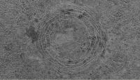
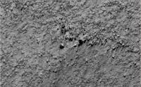
The image I showed is PSP_006996_2480_RED. I don't have time to do any full-res crops, but maybe someone else can play with it.
Phil -------------------- ... because the Solar System ain't gonna map itself.
Also to be found posting similar content on https://mastodon.social/@PhilStooke Maps for download (free PD: https://upload.wikimedia.org/wikipedia/comm...Cartography.pdf NOTE: everything created by me which I post on UMSF is considered to be in the public domain (NOT CC, public domain) |
|
|
|
|
Apr 14 2008, 12:37 PM
Post
#128
|
|
|
Member Group: Members Posts: 315 Joined: 1-October 06 Member No.: 1206 |
Wow! Are they relaxed impact craters or collapsed Martian pingos?
p |
|
|
|
|
Apr 14 2008, 12:44 PM
Post
#129
|
|||||
 The Poet Dude Group: Moderator Posts: 5551 Joined: 15-March 04 From: Kendal, Cumbria, UK Member No.: 60 |
I'll have a go...
Here's a close-up of one of those intriguing "rings"...
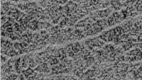
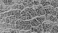
And some full-resolution crops just taken at random from the HiRISE image...
-------------------- |
||||
|
|
|
||||
|
Apr 14 2008, 12:46 PM
Post
#130
|
|||
|
The Poet Dude Group: Moderator Posts: 5551 Joined: 15-March 04 From: Kendal, Cumbria, UK Member No.: 60 |
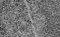
... and a couple more...
-------------------- |
||
|
|
|
||
|
Apr 14 2008, 06:36 PM
Post
#131
|
|
 Member Group: Members Posts: 646 Joined: 23-December 05 From: Forest of Dean Member No.: 617 |
QUOTE (Stu @ Apr 14 2008, 12:46 PM)  ... and a couple more... Paging Tony Robinson... looks like a archeological geophysical survey showing medieval field boundaries. Or cells in a leaf? My brain's interpreting the light coloured branching pattern material as topologically higher, is that purely a trick of the eye? -------------------- --
Viva software libre! |
|
|
|
|
Apr 14 2008, 06:39 PM
Post
#132
|
|
|
The Poet Dude Group: Moderator Posts: 5551 Joined: 15-March 04 From: Kendal, Cumbria, UK Member No.: 60 |
I was thinking the bright "branches" are kind of troughs, with a floor of light material. I have been interpreting the dark "spots" as mounds or dunes with defrosting tops... any input from anyone else on this..?
-------------------- |
|
|
|
|
Apr 14 2008, 07:17 PM
Post
#133
|
|
 Junior Member Group: Members Posts: 90 Joined: 20-April 05 Member No.: 289 |
Would it be possible to add some measure of scale onto these pictures?
It's a bit difficult to visualise the size of the 'objects' we are looking at. Cheers! |
|
|
|
|
Apr 14 2008, 07:19 PM
Post
#134
|
|
|
The Poet Dude Group: Moderator Posts: 5551 Joined: 15-March 04 From: Kendal, Cumbria, UK Member No.: 60 |
The pictures I posted are at the maximum HiRISE resolution possible... I'm sure that the scale info you need is available on the HiRISE site somewhere, or maybe someone else can tell you. Sorry I can't help more, I'm tied up with the Peter Smith live Q&A over on Rui's spacEurope blog at the mo...
-------------------- |
|
|
|
|
Apr 14 2008, 07:20 PM
Post
#135
|
|
|
Senior Member Group: Members Posts: 1229 Joined: 24-December 05 From: The blue one in between the yellow and red ones. Member No.: 618 |
My eyes are being tricked similarly to imipak's. Is the light generally coming from the top of the images? I seem to see 'boulders' with 'shadows' below. What is the minimum size of boulders we can resolve? Basketballs? Beachballs?
Fascinating stuff, but I really wish I knew what I was seeing. Patterns of light 'frost' and dark 'dust'?? Are there any tundra experts able to help?? Does standing on your head help? Ouch. No. Do these patterns change seasonally? -------------------- My Grandpa goes to Mars every day and all I get are these lousy T-shirts!
|
|
|
|
|

|
Lo-Fi Version | Time is now: 27th April 2024 - 11:18 PM |
|
RULES AND GUIDELINES Please read the Forum Rules and Guidelines before posting. IMAGE COPYRIGHT |
OPINIONS AND MODERATION Opinions expressed on UnmannedSpaceflight.com are those of the individual posters and do not necessarily reflect the opinions of UnmannedSpaceflight.com or The Planetary Society. The all-volunteer UnmannedSpaceflight.com moderation team is wholly independent of The Planetary Society. The Planetary Society has no influence over decisions made by the UnmannedSpaceflight.com moderators. |
SUPPORT THE FORUM Unmannedspaceflight.com is funded by the Planetary Society. Please consider supporting our work and many other projects by donating to the Society or becoming a member. |
|