Landing Site Imagery |

  |
Landing Site Imagery |
 Apr 14 2008, 09:05 PM Apr 14 2008, 09:05 PM
Post
#136
|
|
 Senior Member  Group: Admin Posts: 4763 Joined: 15-March 05 From: Glendale, AZ Member No.: 197 |
QUOTE (Shaka @ Apr 14 2008, 11:20 AM)  I seem to see 'boulders' with 'shadows' below. What is the minimum size of boulders we can resolve? Basketballs? Beachballs? Based on the images of the MERs I think we are looking at Armchairs and Volkswagons (if I may coin a few new units of measure). -------------------- If Occam had heard my theory, things would be very different now.
|
 |
 
|
|
Apr 15 2008, 12:49 AM
Post
#137
|
|
 Senior Member Group: Members Posts: 1229 Joined: 24-December 05 From: The blue one in between the yellow and red ones. Member No.: 618 |
Hmmm. I can't believe the shadow of the camera mast was the width of an armchair, Dan'l, ... a basketball maybe...but I would have guessed a softball... or one of those midget footballs... at most two squash balls...

-------------------- My Grandpa goes to Mars every day and all I get are these lousy T-shirts!
|
|
|
|
|
Apr 15 2008, 05:48 AM
Post
#138
|
|||||
 The Poet Dude Group: Moderator Posts: 5551 Joined: 15-March 04 From: Kendal, Cumbria, UK Member No.: 60 |
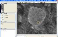
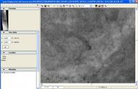
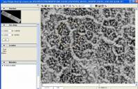
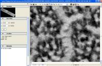
This is a very quick and crude attempt to put some sort of scale to the landing site images... if I'm way out here, and making a mistake somewhere then my apologies, but I wanted to have a try!
 I've kept the same scale throughout this process so, in theory, this should be "right", but if it isn't then I'm happy to be told so - and for someone else to have a go! I've kept the same scale throughout this process so, in theory, this should be "right", but if it isn't then I'm happy to be told so - and for someone else to have a go! Ok, here's a HiRISE 1:1 view of Spitrit (circled) at Homeplate...
... and if you magnify Spirit x4 by clicking the "+" magnifying option you get this...
Now, here's a 1:1 view of a section of the HiRISE Phoenix image covering part of the landing elipse, which should be to the same scale as that Homeplate image...
... and zooming in on a part of that at x4 this is what we see...
So... judge for yourself... how big will Phoenix be on HiRISE images? Well, it's certainly quite a bit bigger than SPirit, so it should be easy to see I reckon... and it looks like that light-coloured "mound" in the centre of the circle in the x4 Phoenix lz image is roughly 3x as big as Spirit, perhaps a little larger... Like I said, might be wrong here, but it's the best I can do with ten minutes to go before I have to be out the door and on my way to work. -------------------- |
||||
|
|
|
||||
|
Apr 15 2008, 07:31 AM
Post
#139
|
|
|
Founder Group: Chairman Posts: 14432 Joined: 8-February 04 Member No.: 1 |
QUOTE (Stu @ Apr 15 2008, 06:48 AM) how big will Phoenix be on HiRISE images? http://www.unmannedspaceflight.com/index.p...ost&p=81794 My sims are unarguably too sharp - but they do represent the right sort of size object. For those easily confused - they're only sending one...not six to land in a circle (I had to say that about the mock version of the MPF presidential pan that has about a dozen sojourners on it once ) D |
|
|
|
|
Apr 15 2008, 08:29 AM
Post
#140
|
|
 Senior Member Group: Members Posts: 2173 Joined: 28-December 04 From: Florida, USA Member No.: 132 |
QUOTE (djellison @ Apr 15 2008, 02:31 AM) Later in that same thread you posted an altered version reflecting the programed East-West landing orientation: |
|
|
|
|
Apr 15 2008, 01:42 PM
Post
#141
|
|
|
The Poet Dude Group: Moderator Posts: 5551 Joined: 15-March 04 From: Kendal, Cumbria, UK Member No.: 60 |
Thanks Doug, I did remember you posting that, but someone asked about the scale of the features on the HiRISE images, so I was only using those crops to try and show how big local landscape and terrain features were, not how big Phoenix itself would be.
-------------------- |
|
|
|
|
Apr 22 2008, 11:06 PM
Post
#142
|
||
 Administrator Group: Admin Posts: 5172 Joined: 4-August 05 From: Pasadena, CA, USA, Earth Member No.: 454 |
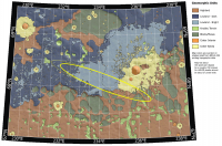
Just for fun, here's a version of that USGS base map (PIA09946), with only the "early in the window" ellipse drawn, and shifted (I think) about 13 km to the southeast. I left a sketch of the original ellipse in there, drawn with a finer line. Do I have this about right?
--Emily
-------------------- My website - My Patreon - @elakdawalla on Twitter - Please support unmannedspaceflight.com by donating here.
|
|
|
|
|
|
|
Apr 22 2008, 11:18 PM
Post
#143
|
|
|
Solar System Cartographer Group: Members Posts: 10153 Joined: 5-April 05 From: Canada Member No.: 227 |
Looking good, Emily!
Phil -------------------- ... because the Solar System ain't gonna map itself.
Also to be found posting similar content on https://mastodon.social/@PhilStooke Maps for download (free PD: https://upload.wikimedia.org/wikipedia/comm...Cartography.pdf NOTE: everything created by me which I post on UMSF is considered to be in the public domain (NOT CC, public domain) |
|
|
|
|
Apr 23 2008, 08:58 PM
Post
#144
|
||
|
Administrator Group: Admin Posts: 5172 Joined: 4-August 05 From: Pasadena, CA, USA, Earth Member No.: 454 |
More of me trying to get myself oriented...is this right?
--Emily
-------------------- My website - My Patreon - @elakdawalla on Twitter - Please support unmannedspaceflight.com by donating here.
|
|
|
|
|
|
|
Apr 23 2008, 09:45 PM
Post
#145
|
||
|
Member Group: Members Posts: 279 Joined: 19-August 07 Member No.: 3299 |
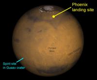
According to the output of the NASA Web :
The Phonix landing site is shown on the following image:
|
|
|
|
|
|
|
Apr 23 2008, 10:37 PM
Post
#146
|
|
|
Senior Member Group: Admin Posts: 4763 Joined: 15-March 05 From: Glendale, AZ Member No.: 197 |
I think you need to move a little bit to the East Emily.
-------------------- If Occam had heard my theory, things would be very different now.
|
|
|
|
|
Apr 24 2008, 10:24 AM
Post
#147
|
|
 Member Group: Members Posts: 646 Joined: 23-December 05 From: Forest of Dean Member No.: 617 |
This is probably a silly question, but I've not been able to find an answer elsewhere on the web. Does the Phoenix target area have a better name than "northern polar region"? What's the equivalent of 'Gusev Crater' or 'Meridiani Planum' for Phoenix?
-------------------- --
Viva software libre! |
|
|
|
|
Apr 24 2008, 10:46 AM
Post
#148
|
|
|
Merciless Robot Group: Admin Posts: 8783 Joined: 8-December 05 From: Los Angeles Member No.: 602 |
I believe that the name of the entire north polar plains region is Vastias Borealis.
-------------------- A few will take this knowledge and use this power of a dream realized as a force for change, an impetus for further discovery to make less ancient dreams real.
|
|
|
|
|
Apr 24 2008, 10:51 AM
Post
#149
|
|
|
Solar System Cartographer Group: Members Posts: 10153 Joined: 5-April 05 From: Canada Member No.: 227 |
The very broad plain around the north pole is called Vastitas Borealis (Northern Plain, or Northern Waste). This specific area has a group of low hills forming the sides of "Green Valley". They are called Scandia Colles (Scandia Hills). The actual site, "Green Valley" is an informal name. Here's a map:
http://planetarynames.wr.usgs.gov/images/mc1_mola.pdf The site's at the left edge, about 10 o'clock. Phil -------------------- ... because the Solar System ain't gonna map itself.
Also to be found posting similar content on https://mastodon.social/@PhilStooke Maps for download (free PD: https://upload.wikimedia.org/wikipedia/comm...Cartography.pdf NOTE: everything created by me which I post on UMSF is considered to be in the public domain (NOT CC, public domain) |
|
|
|
|
Apr 24 2008, 11:02 AM
Post
#150
|
|
 Special Cookie Group: Members Posts: 2168 Joined: 6-April 05 From: Sintra | Portugal Member No.: 228 |
Huum Scandia...it pleases me...
-------------------- "Ride, boldly ride," The shade replied, "If you seek for Eldorado!"
Edgar Alan Poe |
|
|
|
|

|
Lo-Fi Version | Time is now: 28th April 2024 - 12:10 AM |
|
RULES AND GUIDELINES Please read the Forum Rules and Guidelines before posting. IMAGE COPYRIGHT |
OPINIONS AND MODERATION Opinions expressed on UnmannedSpaceflight.com are those of the individual posters and do not necessarily reflect the opinions of UnmannedSpaceflight.com or The Planetary Society. The all-volunteer UnmannedSpaceflight.com moderation team is wholly independent of The Planetary Society. The Planetary Society has no influence over decisions made by the UnmannedSpaceflight.com moderators. |
SUPPORT THE FORUM Unmannedspaceflight.com is funded by the Planetary Society. Please consider supporting our work and many other projects by donating to the Society or becoming a member. |
|