Landing Site Imagery |

  |
Landing Site Imagery |
 May 21 2008, 02:16 AM May 21 2008, 02:16 AM
Post
#166
|
|
|
Solar System Cartographer  Group: Members Posts: 10153 Joined: 5-April 05 From: Canada Member No.: 227 |
Now all we need is a few new placenames...
That prominent hill to the south of the ellipse center looks like the most likely feature - IF any - to show over the horizon. Phil -------------------- ... because the Solar System ain't gonna map itself.
Also to be found posting similar content on https://mastodon.social/@PhilStooke Maps for download (free PD: https://upload.wikimedia.org/wikipedia/comm...Cartography.pdf NOTE: everything created by me which I post on UMSF is considered to be in the public domain (NOT CC, public domain) |
 |
 
|
|
May 21 2008, 04:34 AM
Post
#167
|
||
|
Member Group: Members Posts: 111 Joined: 14-March 05 From: Vastitas Borealis Member No.: 193 |
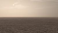
An anaglyph from the newest landing ellipse centerline, about 9 kilometers down (ESE) from the centerpoint. The new center line cuts the frame in half, from upper left to lower right (not shown). The image is half of the normal HiRISE resolution and its width is approximately 550 m. I don't think there's significant exaggeration compared to a realistic elevation model, very little at best.
Images used: PSP_002249_2485 (left eye) PSP_002328_2485 (right eye) No mountains visible, but the surface is far from featureless! Enjoy.
Attached thumbnail(s)
|
|
|
|
|
|
|
May 21 2008, 07:05 AM
Post
#168
|
||
|
Founder Group: Chairman Posts: 14432 Joined: 8-February 04 Member No.: 1 |
This is the best I can do with one of Randy's DEM's. To be honest, I could save myself a lot of render time and not use the full resolution of the DEM itself, and just pre-displace a 100 x 100 poly plane.
Doug
Attached thumbnail(s)
|
|
|
|
|
|
|
May 21 2008, 08:03 AM
Post
#169
|
|
|
Rover Driver Group: Members Posts: 1015 Joined: 4-March 04 Member No.: 47 |
who cares about the surface anyway?
 I'm very curious to see if the subsurface will be more interesting than the surface. I would think it is I'm very curious to see if the subsurface will be more interesting than the surface. I would think it is 
|
|
|
|
|
May 21 2008, 08:35 AM
Post
#170
|
|
 Special Cookie Group: Members Posts: 2168 Joined: 6-April 05 From: Sintra | Portugal Member No.: 228 |
QUOTE (marswiggle @ May 21 2008, 05:34 AM)  An anaglyph from the newest landing ellipse centerline I like that! 
-------------------- "Ride, boldly ride," The shade replied, "If you seek for Eldorado!"
Edgar Alan Poe |
|
|
|
|
May 21 2008, 09:02 AM
Post
#171
|
|
|
Junior Member Group: Members Posts: 33 Joined: 13-April 05 Member No.: 232 |
Can I ask - on the USGS geological map, what's the meaning of that funny meandering line of dashes that cuts more or less through the centre of the landing ellipse?
|
|
|
|
|
May 21 2008, 09:28 AM
Post
#172
|
|
|
Special Cookie Group: Members Posts: 2168 Joined: 6-April 05 From: Sintra | Portugal Member No.: 228 |
QUOTE (Phil Stooke @ May 21 2008, 03:16 AM) Now all we need is a few new placenames... I agree... If I think that ACC Memorial Station would be a fitting name for Phoenix's landing site, as we're going to the North Pole I would, somehow, like to see a reference to: EDITED: forget what was written here before...  -Peary, Henson and the Inuits (does anybody know Inuit words?) Edited again: Got one!: Tunnga-sugitsi It stands for "you are welcome here" A nice way of making Phoenix feel at home...
-------------------- "Ride, boldly ride," The shade replied, "If you seek for Eldorado!"
Edgar Alan Poe |
|
|
|
|
May 21 2008, 12:32 PM
Post
#173
|
|
|
Member Group: Members Posts: 100 Joined: 11-October 04 From: Oxford, UK (Glasgow by birth) Member No.: 101 |
Rui,
"Tunnga-sugitsi" Sounds a bit too much like "Tunguska" for my liking and we all know what happened there........ http://en.wikipedia.org/wiki/Tunguska_event Brian -------------------- "There are 10 types of people in the world - those who understand binary code, and those who don't."
|
|
|
|
|
May 21 2008, 12:42 PM
Post
#174
|
|
|
Special Cookie Group: Members Posts: 2168 Joined: 6-April 05 From: Sintra | Portugal Member No.: 228 |
Didn't think of that...
 Here's a list of words we can play with... I like particularly "aimerpok" which stands for "visiting and expecting food"
-------------------- "Ride, boldly ride," The shade replied, "If you seek for Eldorado!"
Edgar Alan Poe |
|
|
|
|
May 21 2008, 01:45 PM
Post
#175
|
|
|
Member Group: Senior Member Posts: 136 Joined: 8-August 06 Member No.: 1022 |
QUOTE (elakdawalla @ May 20 2008, 10:33 AM) You'd think I'd get paid better if that were the case! Well, I do get to do fun stuff, I suppose... I didn't complete my update of the map until late evening last night, and the frustrating thing about going from a graphics program like Canvas to some raster image format for the plotter is that I had to reduce the resolution of the HiRISE images tremendously to keep the file size down (and get home before too late!). I built the Canvas map with 4 meter/pixel versions of the HiRISE images, but by the time I rastered the file, the result was more like 8 meters/pixel. That's still probably sufficient for triangulation to horizon features. And once we know which HiRISE image(s) the lander resides in, matching to local rocks and bumps (hah!) at full resolution will be possible (and immediately "obsolete" the map!). -Tim. |
|
|
|
|
May 21 2008, 01:50 PM
Post
#176
|
|
|
Member Group: Senior Member Posts: 136 Joined: 8-August 06 Member No.: 1022 |
QUOTE (Phil Stooke @ May 20 2008, 06:16 PM) Now all we need is a few new placenames... That prominent hill to the south of the ellipse center looks like the most likely feature - IF any - to show over the horizon. Phil Phil: I'm optimistic for two reasons: Number A: Some of the massifs to either side of the trajectory are over 100 meters tall. If Phoenix lands within 20 or 30 kilometers of these, I think they should be visible (remember that Far Knob in MPF was over 35 kilometers away, though it was something like 450 meters tall, IIRC). Letter 2: Phoenix's camera has on order 4 times the resolution of the IMP, making Number A easier. But we'll see! -Tim. |
|
|
|
|
May 21 2008, 06:42 PM
Post
#177
|
|
|
Member Group: Members Posts: 428 Joined: 21-August 06 From: Northern Virginia Member No.: 1062 |
QUOTE (tim53 @ May 21 2008, 06:45 AM) You'd think I'd get paid better if that were the case! Well, I do get to do fun stuff, I suppose... -Tim. I had long suspected that you were Tim Parker, it's nice to finally have evidence in that direction. |
|
|
|
|
May 21 2008, 07:41 PM
Post
#178
|
|
|
Solar System Cartographer Group: Members Posts: 10153 Joined: 5-April 05 From: Canada Member No.: 227 |
Number A and Letter 2... an Archie Bunker fan perhaps?
"A, he's unemployed, and 2, he don't woik!" Phil -------------------- ... because the Solar System ain't gonna map itself.
Also to be found posting similar content on https://mastodon.social/@PhilStooke Maps for download (free PD: https://upload.wikimedia.org/wikipedia/comm...Cartography.pdf NOTE: everything created by me which I post on UMSF is considered to be in the public domain (NOT CC, public domain) |
|
|
|
|
May 22 2008, 01:02 AM
Post
#179
|
|
|
Merciless Robot Group: Admin Posts: 8783 Joined: 8-December 05 From: Los Angeles Member No.: 602 |
As long as we don't have Meathead Mountain on the distant horizon...

-------------------- A few will take this knowledge and use this power of a dream realized as a force for change, an impetus for further discovery to make less ancient dreams real.
|
|
|
|
|
May 22 2008, 04:17 AM
Post
#180
|
|
|
Member Group: Members Posts: 599 Joined: 26-August 05 Member No.: 476 |
QUOTE (tuvas @ May 21 2008, 11:42 AM) I had long suspected that you were Tim Parker, it's nice to finally have evidence in that direction. He's a Junior Member by post count, but Doug made a Senior Member group just for him and of which he is the only member. |
|
|
|
|

|
Lo-Fi Version | Time is now: 28th April 2024 - 03:02 PM |
|
RULES AND GUIDELINES Please read the Forum Rules and Guidelines before posting. IMAGE COPYRIGHT |
OPINIONS AND MODERATION Opinions expressed on UnmannedSpaceflight.com are those of the individual posters and do not necessarily reflect the opinions of UnmannedSpaceflight.com or The Planetary Society. The all-volunteer UnmannedSpaceflight.com moderation team is wholly independent of The Planetary Society. The Planetary Society has no influence over decisions made by the UnmannedSpaceflight.com moderators. |
SUPPORT THE FORUM Unmannedspaceflight.com is funded by the Planetary Society. Please consider supporting our work and many other projects by donating to the Society or becoming a member. |
|