Landing Site Imagery |

  |
Landing Site Imagery |
 May 23 2008, 03:24 PM May 23 2008, 03:24 PM
Post
#196
|
|
|
Merciless Robot  Group: Admin Posts: 8783 Joined: 8-December 05 From: Los Angeles Member No.: 602 |
 Definitely, Stu! Definitely, Stu! However, I sure wouldn't mind if we came down within a few meters of one of these. Shooting from the hip, here, those look one hell of a lot like fresh fractures that have permitted sublimation & recrystallization of H2O...perhaps evidence of VERY extensive subsurface ice? -------------------- A few will take this knowledge and use this power of a dream realized as a force for change, an impetus for further discovery to make less ancient dreams real.
|
 |
 
|
|
May 23 2008, 03:47 PM
Post
#197
|
|
 Senior Member Group: Members Posts: 2173 Joined: 28-December 04 From: Florida, USA Member No.: 132 |
QUOTE (Stu @ May 23 2008, 11:16 AM)  ... and a second candidate for the "Places Best Avoided" list... Quit showing those interesting features! You'll get the "Phoenix should have wheels" people started up all over again! 
|
|
|
|
|
May 23 2008, 04:13 PM
Post
#198
|
|
|
Senior Member Group: Members Posts: 2920 Joined: 14-February 06 From: Very close to the Pyrénées Mountains (France) Member No.: 682 |
QUOTE (centsworth_II @ May 23 2008, 05:47 PM) Quit showing those interesting features! You'll get the "Phoenix should have wheels" people started up all over again! As far as "Phoenix has wings" occurs, I don't mind too much ! -------------------- |
|
|
|
|
May 23 2008, 06:46 PM
Post
#199
|
||
 The Poet Dude Group: Moderator Posts: 5551 Joined: 15-March 04 From: Kendal, Cumbria, UK Member No.: 60 |
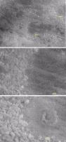
This is one of my favourite crops so far, and I think it shows that Doug's winning entry in Rui's art competition is probably very prescient... A few rocks, here and there, some vertical relief, here and there... maybe some low ridges, shallow trenches...
Can't help thinking the HiRISE team is cheating and actually photographing rhino hide with a close-up lens... 
-------------------- |
|
|
|
|
|
|
May 23 2008, 06:52 PM
Post
#200
|
|
 Special Cookie Group: Members Posts: 2168 Joined: 6-April 05 From: Sintra | Portugal Member No.: 228 |
I can't avoid to think, looking at that image, that this is a tricky ground...tricky tricky...
-------------------- "Ride, boldly ride," The shade replied, "If you seek for Eldorado!"
Edgar Alan Poe |
|
|
|
|
May 23 2008, 06:54 PM
Post
#201
|
|
 Senior Member Group: Members Posts: 3648 Joined: 1-October 05 From: Croatia Member No.: 523 |
What's so tricky about it? Doesn't look like anything Phoenix wouldn't handle to me. It's definitely going to wind up with some small tilt when it lands, with some luck it just might be tilted towards the south.

-------------------- |
|
|
|
|
May 23 2008, 07:00 PM
Post
#202
|
|
|
The Poet Dude Group: Moderator Posts: 5551 Joined: 15-March 04 From: Kendal, Cumbria, UK Member No.: 60 |
Yep, I agree... I'd much rather our bird touches down here than in one of those Death Star trenches...!
-------------------- |
|
|
|
|
May 23 2008, 09:20 PM
Post
#203
|
|
 Member Group: Members Posts: 646 Joined: 23-December 05 From: Forest of Dean Member No.: 617 |
QUOTE (ugordan @ May 23 2008, 07:54 PM) What's so tricky about it? Isn't there a scale law somewhere that says a surface that looks smooth at one scale will be rough at the next scale down? It looks very smooth on scales of tens of metres, but a successful landing needs (some value of) smoothness at a scale of 0-9m. Lawks! now I'm worrying myself What I'd really love to see would be Doug's simulations of post-landing HiRISE images reprojected on these images... I can't quite visualise the scale of the vehicle in these landscapes. -------------------- --
Viva software libre! |
|
|
|
|
May 24 2008, 12:51 AM
Post
#204
|
|
|
Senior Member Group: Members Posts: 2920 Joined: 14-February 06 From: Very close to the Pyrénées Mountains (France) Member No.: 682 |
QUOTE (imipak @ May 23 2008, 11:20 PM) I can't quite visualise the scale of the vehicle in these landscapes. Yep! it's what I was to ask too! Stu, can you add a scale bar? I would say that Doug entry in the competition will be close but I think the terrain will be a little bit not thta flat. Only 47 hours to go! -------------------- |
|
|
|
|
May 24 2008, 02:56 AM
Post
#205
|
|
|
Merciless Robot Group: Admin Posts: 8783 Joined: 8-December 05 From: Los Angeles Member No.: 602 |
QUOTE (ustrax @ May 23 2008, 10:52 AM) I can't avoid to think, looking at that image, that this is a tricky ground...tricky tricky... Yeah...reluctantly, I have to agree. Assuming that this is a max resolution image, it sure looks like we have numerous 'rilles' of at least 0.5m in elevation (or depression!) spaced rather closely together. Gordan mentioned earlier that we might think about getting ready for some slanted landscape views...think he's right. She's gonna make it, though, and in fact make it look easy after the fact. GO PHOENIX!!!! -------------------- A few will take this knowledge and use this power of a dream realized as a force for change, an impetus for further discovery to make less ancient dreams real.
|
|
|
|
|
May 24 2008, 03:03 AM
Post
#206
|
|
|
Member Group: Members Posts: 154 Joined: 8-June 04 Member No.: 80 |
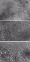
QUOTE (Stu @ May 22 2008, 03:47 PM) Well, I've been wandering around the latest HiRISE Phoenix landing site image, and I've found some very interesting (well, I think they are anyway!) features that suggest it's at least possible we might see some decent surface relief... A couple of these images have me really puzzled, to be honest, because the lighting conditions are very confusing. So I'm not sure if they're real features, casting shadows, or some strange kind of lens flare effect. Anyway, take a look experts, and see what you make of these... [attachment=14285:bright_spots.jpg] What's that then?  [attachment=14286:bright_spots_2.jpg] ... and that? A quite high ridge with frost on the top? But this is making me scratch my head in a not-too-good way... [attachment=14287:trench.jpg] That looks like either a steep-sided trench, or a very narrow, steep ridge, depending on how I look at it. What do you think? Either way, landing on that would give Phoenix's pix a tilting horizon, wouldn't it..? Feel free to ignore, I'm just killing time before making tea...  What is the resolution of these images? |
|
|
|
|
May 24 2008, 05:51 AM
Post
#207
|
|
|
The Poet Dude Group: Moderator Posts: 5551 Joined: 15-March 04 From: Kendal, Cumbria, UK Member No.: 60 |
Resolution: the usual 1:1 on IAS Viewer which I think corresponds to 30cm pixel...
-------------------- |
|
|
|
|
May 24 2008, 07:43 AM
Post
#208
|
|
|
Founder Group: Chairman Posts: 14432 Joined: 8-February 04 Member No.: 1 |
If it's the map projected imagery, it's normally 25cm/pixel.
Doug |
|
|
|
|
Jun 23 2008, 08:08 AM
Post
#209
|
|||
 Senior Member Group: Members Posts: 1887 Joined: 20-November 04 From: Iowa Member No.: 110 |
I've been taking a second look at the HiRISE image of the Phoenix landing, in particular the large scale light and dark patterns.
The large scale darker areas such as the area where Phoenix landed appears to be darker because of the prominent dark polygons. The large scale lighter area in contrast lack the prominent dark polygons, a second difference is the rougher appearance with more relief at scales larger than the polygons. The difference between the light and dark areas near Phoenix is apparent in the HiRISE image of the area around Phoenix, I've included a couple of closeups the show the polygons in the dark areas.
Looking at an area somewhat farther north in the same HiRISE image the dark areas look somewhat like ponds in the image, appearing to fill a low lying area.
Obviously a pond of water cannot form on the surface of Mars. Water is not stable at at the low atmospheric pressure and would vaporize quite quickly. Perhaps instead the dark areas may be areas where a water table exists temporarily below the surface. The polygonal patterns imply that a freeze thaw cycle occurs in the area. When the ice melts below the surface water may travel from the higher rough terrain down into lower areas forming pools just below the surface. This could explain the correlation between the dark polygons and the areas with the lowest relief and would imply that Phoenix landed over an area where water may collect below the surface or at least may have collected below the surface at some time in the past however long ago that may have been. |
||
|
|
|
||
|
Jun 23 2008, 12:18 PM
Post
#210
|
|
|
Senior Member Group: Members Posts: 2998 Joined: 30-October 04 Member No.: 105 |
I was thinking that "THE" HiRISE landing site image was PSP_0022490_2485 and the location was +68.2, 234.3 deg. I've been trying to match to the orbital views with Phil Stooke's Polar Pans but have had -zip- success. The landscape has a truly fractal appearance and I've not seen many landmarks. Did I take a preliminary locations as gospel?
Anyway, I don't think we're seeing frozen ponds of water, nor a frozen shallow groundwater table. Remember, Mars has significant polar drift, and what is now polar was once equatorial a brief few hundred million years ago. Relative recent surface conditions do not allow for standing bodies of water, and whatever liquid could form quickly evaporated. I believe that the source of the ice we are finding will be hoarfrost with interbedded regolith. I may be completely off base here, but we'll see what the chemistry of the site is and what further digging shows. --Bill -------------------- |
|
|
|
|

|
Lo-Fi Version | Time is now: 28th April 2024 - 03:44 PM |
|
RULES AND GUIDELINES Please read the Forum Rules and Guidelines before posting. IMAGE COPYRIGHT |
OPINIONS AND MODERATION Opinions expressed on UnmannedSpaceflight.com are those of the individual posters and do not necessarily reflect the opinions of UnmannedSpaceflight.com or The Planetary Society. The all-volunteer UnmannedSpaceflight.com moderation team is wholly independent of The Planetary Society. The Planetary Society has no influence over decisions made by the UnmannedSpaceflight.com moderators. |
SUPPORT THE FORUM Unmannedspaceflight.com is funded by the Planetary Society. Please consider supporting our work and many other projects by donating to the Society or becoming a member. |
|