Continuing into Glenelg, Leaving Rocknest behind, sols 102-166 (Nov 18 2012-Jan 23, 2013) |

  |
Continuing into Glenelg, Leaving Rocknest behind, sols 102-166 (Nov 18 2012-Jan 23, 2013) |
 Dec 14 2012, 04:26 PM Dec 14 2012, 04:26 PM
Post
#271
|
||
 The Poet Dude  Group: Moderator Posts: 5551 Joined: 15-March 04 From: Kendal, Cumbria, UK Member No.: 60 |
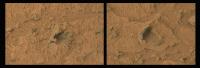
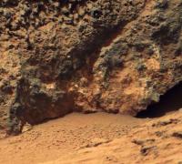
Fred's well-spotted "Half Dome" (right) and another one nearby, both enhanced to bring out details...
-------------------- |
|
 |
 
|
|
|
Dec 14 2012, 05:15 PM
Post
#272
|
|||
 Member Group: Members Posts: 154 Joined: 19-September 12 Member No.: 6658 |
From sol 114:
Whatever it is composed of - visually the fine shine let it look like soapstone. |
||
|
|
|
||
|
Dec 14 2012, 05:54 PM
Post
#273
|
|
 Senior Member Group: Members Posts: 1619 Joined: 12-February 06 From: Bergerac - FR Member No.: 678 |
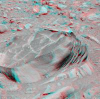
Thank you ronald for these stereoscopic view.
I'm adding a color anaglyph, and so it's complete  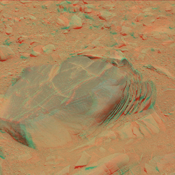
-------------------- |
|
|
|
|
Dec 14 2012, 07:13 PM
Post
#274
|
||
|
Solar System Cartographer Group: Members Posts: 10154 Joined: 5-April 05 From: Canada Member No.: 227 |
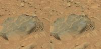
Chemcam mosaic, sol 126 - it's getting hard to distinguish this from the MIs at Endeavour.
Phil
-------------------- ... because the Solar System ain't gonna map itself.
Also to be found posting similar content on https://mastodon.social/@PhilStooke Maps for download (free PD: https://upload.wikimedia.org/wikipedia/comm...Cartography.pdf NOTE: everything created by me which I post on UMSF is considered to be in the public domain (NOT CC, public domain) |
|
|
|
|
|
|
Dec 14 2012, 07:16 PM
Post
#275
|
|
 Senior Member Group: Moderator Posts: 3431 Joined: 11-August 04 From: USA Member No.: 98 |
QUOTE (iMPREPREX @ Dec 13 2012, 04:21 PM)  And is the raw-image site being wonky or is it just me? Images aren't showing up as they used to. Some retrieval tool sites show images first. Then sometimes, the raw-image site has the images first. It isn't just you. View-by-sol on the raw images pages still isn't reliably showing all images right away. For example, right now http://mars.jpl.nasa.gov/msl/multimedia/raw/?s=126 shows two ChemCam images while http://mars.jpl.nasa.gov/msl/multimedia/ra...126&camera= shows five. It might correct itself after a while. But this has already been discussed in the Image Retrieval Tools thread, and further discussion of it should probably go there (just wanted you to know you're not imagining things). I think a simple workaround is to view by instrument. |
|
|
|
|
Dec 14 2012, 08:22 PM
Post
#276
|
|
|
Member Group: Members Posts: 384 Joined: 4-January 07 Member No.: 1555 |
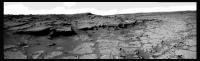
QUOTE (acastillo @ Dec 14 2012, 08:13 AM) Wow! Looks like some beautiful cross-bedding, especially on the outcrop in the middle. What I can't help noticing exposed in the block in the center is a beautiful example of a disconformity (erosion surface, caused by scouring) between the cross-bedded coarse-grained material on top (what I was commenting on in #259 above) and likewise cross-bedded, but uniformly fine-grained material on the bottom. In terms of transport environments, the beds on top represent a relatively high-energy environment, able to move the larger, darker grains, and the beds on the bottom represent a relatively low-energy environment, where only lighter dust or fine sand grains could be moved. The nature of the fluid involved in this transport is open to debate. -dburt |
|
|
|
|
Dec 14 2012, 09:13 PM
Post
#277
|
|
|
Junior Member Group: Members Posts: 30 Joined: 6-September 12 From: Denver Member No.: 6641 |
Good observation about the disconformity. These morphologies certainly seem to agree with this being at the tail end of an ancient alluvial fan, possibly emptying into a lake. Given the relatively small thickness of the beds and the low angle of the cross-bedding, it argues for water being the transporting fluid. This contrasts with the classical wind-driven cross bedding example on Earth, the Navajo sandstone, which you referred to in your post #259. If my memory is correct, the thickness of the cross-bedding in the Navajo sandstone is on the order of tens of meters to hundreds of meters, much larger than what we are seeing here on Mars.
|
|
|
|
|
Dec 15 2012, 12:07 AM
Post
#278
|
|
|
Member Group: Members Posts: 384 Joined: 4-January 07 Member No.: 1555 |
QUOTE (acastillo @ Dec 14 2012, 02:13 PM) ...argues for water being the transporting fluid.... Not necessarily, as I explained in great detail here on UMSF over 5 years ago, and in publications with Paul Knauth and Ken Wohletz earlier. Very similar surface rocks with identical bedding features were imaged by the two rovers Opportunity and Spirit and were attributed to a variety of fluids, including water, wind, and volcanic gas. I suggested all could easily be blast beds, resulting from distant impacts. You can consult those references for details. The debate may still be open after 5 years, but not on these pages PLEASE. -dburt |
|
|
|
| Guest_Actionman_* |
Dec 15 2012, 12:11 AM
Post
#279
|
|
|
Guests |
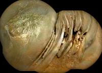
QUOTE (Zelenyikot @ Dec 14 2012, 06:11 AM) Interesting light solid (sol 123). What can it be? Good eye good eye nice find. I cut and color adjusted this from the adjacent image 0123MR0767000000E1. So what is the white material?
Attached thumbnail(s)
|
|
|
|
|
|
|
Dec 15 2012, 12:42 AM
Post
#280
|
|
|
Senior Member Group: Members Posts: 1043 Joined: 17-February 09 Member No.: 4605 |
QUOTE (acastillo @ Dec 14 2012, 10:13 PM) .....If my memory is correct, the thickness of the cross-bedding in the Navajo sandstone is on the order of tens of meters to hundreds of meters, much larger than what we are seeing here on Mars. Well the Meridiani sandstone layers are hundreds of metres thick and for height (= depth) of sedimentary structures Mount Sharp leaves all in its wake. Curiosity will no doubt narrow down the options for deposition in this area but in the interim nothing can be taken for granted despite the pretty strong indications that these beds are associated with the fan. I mean the disconformity could be scour, or a deflationary surface followed by a energetic depositional process, or it could even be a sequence boundary (drowning unconformity) or a change in fluid etc. |
|
|
|
|
Dec 15 2012, 04:08 AM
Post
#281
|
||
|
Solar System Cartographer Group: Members Posts: 10154 Joined: 5-April 05 From: Canada Member No.: 227 |
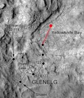
We just had another move towards the rocks, probably positioning for a first test drill. Very rough position:
Phil -------------------- ... because the Solar System ain't gonna map itself.
Also to be found posting similar content on https://mastodon.social/@PhilStooke Maps for download (free PD: https://upload.wikimedia.org/wikipedia/comm...Cartography.pdf NOTE: everything created by me which I post on UMSF is considered to be in the public domain (NOT CC, public domain) |
|
|
|
|
|
|
Dec 15 2012, 05:34 AM
Post
#282
|
||
 Member Group: Members Posts: 215 Joined: 23-October 12 From: Russia Member No.: 6725 |
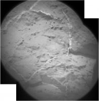
QUOTE (Ant103 @ Dec 14 2012, 05:54 PM) I'm adding a color anaglyph, and so it's complete Colored Chem Cam, sol 117 Now complete
Attached thumbnail(s)
-------------------- My blog on Patreon
|
|
|
|
|
|
|
Dec 15 2012, 09:01 AM
Post
#283
|
||
|
The Poet Dude Group: Moderator Posts: 5551 Joined: 15-March 04 From: Kendal, Cumbria, UK Member No.: 60 |
Lovely place...
-------------------- |
|
|
|
|
|
|
Dec 15 2012, 09:54 AM
Post
#284
|
|
|
Senior Member Group: Members Posts: 1619 Joined: 12-February 06 From: Bergerac - FR Member No.: 678 |
B-b-but ? What have you done with the sky Stu
 ?? ??Sol 127 Navcam pan : 
-------------------- |
|
|
|
|
Dec 15 2012, 10:08 AM
Post
#285
|
|
|
The Poet Dude Group: Moderator Posts: 5551 Joined: 15-March 04 From: Kendal, Cumbria, UK Member No.: 60 |
QUOTE (Ant103 @ Dec 15 2012, 09:54 AM) B-b-but ? What have you done with the sky Stu ??Just wanted to isolate the rocks in the foreground, Ant, they're so dramatic. I'm rubbish at skies anyway!  -------------------- |
|
|
|
|

|
Lo-Fi Version | Time is now: 2nd May 2024 - 02:16 AM |
|
RULES AND GUIDELINES Please read the Forum Rules and Guidelines before posting. IMAGE COPYRIGHT |
OPINIONS AND MODERATION Opinions expressed on UnmannedSpaceflight.com are those of the individual posters and do not necessarily reflect the opinions of UnmannedSpaceflight.com or The Planetary Society. The all-volunteer UnmannedSpaceflight.com moderation team is wholly independent of The Planetary Society. The Planetary Society has no influence over decisions made by the UnmannedSpaceflight.com moderators. |
SUPPORT THE FORUM Unmannedspaceflight.com is funded by the Planetary Society. Please consider supporting our work and many other projects by donating to the Society or becoming a member. |
|