

Updated Titan Map |

  |
Updated Titan Map |
 Apr 3 2013, 10:30 PM Apr 3 2013, 10:30 PM
Post
#196
|
|
|
Member  Group: Members Posts: 890 Joined: 18-November 08 Member No.: 4489 |
a quick run through isis3's "dstripe"
just a first guess , and still needs a bit of work 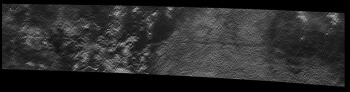 a crop of http://pirlwww.lpl.arizona.edu/~perry/RADA...T059S01_V02.jpg without denoising first , "dstripe" tacks care of most of that ------ for that i tend to use gmic CODE gmic BIUQH67S152_D201_T059S01_V02.jpg -type float -remove_hotpixels 2,1.0% -type uchar -o BIUQH67S152_D201_T059S01_V02.Less.Noise.png that line removes most of the " salt&pepper " |
 |
 
|
|
Apr 5 2013, 03:37 PM
Post
#197
|
|
|
Member Group: Members Posts: 700 Joined: 1-April 08 From: Minnesota ! Member No.: 4081 |
Much thanks JohnVV for above. Have used your image to modify my T59 snippet map on the previous page. Must confess I am a Windows user and not familiar with isis. Is there a destripe type plugin for ImageJ?
|
|
|
|
|
Jan 28 2016, 06:39 PM
Post
#198
|
|
 Member Group: Members Posts: 796 Joined: 27-February 08 From: Heart of Europe Member No.: 4057 |
Preliminary global map of Titan. Version 0.2.0.
Informations are directly in the map and on Flickr page. 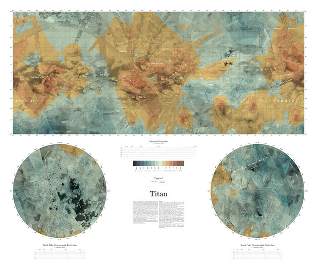
-------------------- |
|
|
|
|
Jan 28 2016, 07:37 PM
Post
#199
|
|
 Senior Member Group: Members Posts: 2530 Joined: 20-April 05 Member No.: 321 |
Beautiful work, Machi! It's a challenge to get the very low-res topographical data merged with the albedo map, but your result is thought-provoking. With my Titan map/globe, I skipped the topographical data to focus on the color, but the topography is definitely worthwhile as well. With better data, a map could provide all three, but low-res topography doesn't lend itself, I guess, to being demonstrated through shading.
|
|
|
|
|
Jan 28 2016, 07:51 PM
Post
#200
|
|
|
Solar System Cartographer Group: Members Posts: 10162 Joined: 5-April 05 From: Canada Member No.: 227 |
Yes! All your maps are really nice, and this superb combination of datasets is very useful, especially since there really is nothing else like it.
Phil -------------------- ... because the Solar System ain't gonna map itself.
Also to be found posting similar content on https://mastodon.social/@PhilStooke Maps for download (free PD: https://upload.wikimedia.org/wikipedia/comm...Cartography.pdf NOTE: everything created by me which I post on UMSF is considered to be in the public domain (NOT CC, public domain) |
|
|
|
|
Jan 28 2016, 08:34 PM
Post
#201
|
|
|
Member Group: Members Posts: 796 Joined: 27-February 08 From: Heart of Europe Member No.: 4057 |
Thanks Phil!
QUOTE (JRehling @ Jan 28 2016, 08:37 PM)  Beautiful work, Machi! It's a challenge to get the very low-res topographical data merged with the albedo map, but your result is thought-provoking. With my Titan map/globe, I skipped the topographical data to focus on the color, but the topography is definitely worthwhile as well. With better data, a map could provide all three, but low-res topography doesn't lend itself, I guess, to being demonstrated through shading. Yes, merging elevation data with SAR/ISS map was maybe the most difficult part. Elevation data have very low resolution (1 or 2 pixels per degree) so topography shading is effectively impossible. So this isn't topographic map, it's SAR/ISS map with overlaying low-res elevation data (BTW, the same data which Ralph Lorenz used in his first ever topographic map of Titan). I also wanted to include VIMS data as in your very nice map but there isn't yet VIMS map with quality which I need. -------------------- |
|
|
|
|
Jan 28 2016, 09:31 PM
Post
#202
|
|
 Lord Of The Uranian Rings Group: Members Posts: 798 Joined: 18-July 05 From: Plymouth, UK Member No.: 437 |
Great map Daniel! I'm only browsing on a mobile device, but even so, the quality and sheer level of detail are clearly evident.
-------------------- |
|
|
|
|
Feb 28 2016, 09:54 PM
Post
#203
|
|
|
Senior Member Group: Members Posts: 1276 Joined: 25-November 04 Member No.: 114 |
Do those maps contain SAR radar data after June 7, 2012?
I have seen no Full swaths released after that date. |
|
|
|
|
Feb 28 2016, 10:31 PM
Post
#204
|
|
|
Senior Member Group: Members Posts: 3516 Joined: 4-November 05 From: North Wales Member No.: 542 |
I've noticed that as well. I check Jason Perry's SAR site from time to time but the flow of new data appears to have stopped.
|
|
|
|
|
Feb 29 2016, 07:14 AM
Post
#205
|
|
|
Lord Of The Uranian Rings Group: Members Posts: 798 Joined: 18-July 05 From: Plymouth, UK Member No.: 437 |
This USGS mosaic contains all radar swathes up to and including the August 2014 T-104 data return:
http://astrogeology.usgs.gov/search/detail...n180_128ppd/cub I used this mosaic and combined part of it with a cleaned and de-seamed and colorized ISS mosaic to produce this dynamic view of Adiri: 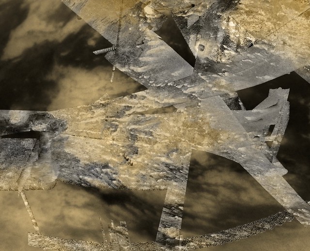 Adiri Mountainous Plateau of Titan by Ian Regan, on Flickr -------------------- |
|
|
|
|
Feb 29 2016, 07:17 AM
Post
#206
|
|
|
Lord Of The Uranian Rings Group: Members Posts: 798 Joined: 18-July 05 From: Plymouth, UK Member No.: 437 |
A list of the recent radar returns:
QUOTE _________________________________________
T-83 --- Sequence S73, May 21, 2012 http://pds-imaging.jpl.nasa.gov/data/cassi...DR_0239/EXTRAS/ _________________________________________ T-84 --- Sequence S73, Jun 06, 2012 http://pds-imaging.jpl.nasa.gov/data/cassi...DR_0240/EXTRAS/ ___________________________________________ T-86 --- Seq S75, Sep 26, 2012 _________________________________________ T-91 --- Seq S78, May 23, 2013 http://pds-imaging.jpl.nasa.gov/data/cassi...DR_0248/EXTRAS/ _________________________________________ T-92 --- Seq S79, July 10, 2013 http://pds-imaging.jpl.nasa.gov/data/cassi...er/CORADR_0250/ _________________________________________ T-95 --- Seq S80,Oct 13, 2013 http://pds-imaging.jpl.nasa.gov/data/cassi...DR_0253/EXTRAS/ _________________________________________ T-98 --- Seq S82, Feb 02, 2014 (redelivery) http://pds-imaging.jpl.nasa.gov/data/cassi...DR_0257/EXTRAS/ _________________________________________ T-104 --- Seq S85,Aug 21, 2014 http://pds-imaging.jpl.nasa.gov/data/cassi...DR_0261/EXTRAS/ -------------------- |
|
|
|
|
Feb 29 2016, 07:59 PM
Post
#207
|
|
 Senior Member Group: Moderator Posts: 3233 Joined: 11-February 04 From: Tucson, AZ Member No.: 23 |
QUOTE (ngunn @ Feb 28 2016, 03:31 PM) I've noticed that as well. I check Jason Perry's SAR site from time to time but the flow of new data appears to have stopped. Yeah, I haven't been keeping it up, mostly because the RADAR team now includes JPG versions of the SAR swaths in the Extras section of their PDS releases, as Ian R links to. -------------------- &@^^!% Jim! I'm a geologist, not a physicist!
The Gish Bar Times - A Blog all about Jupiter's Moon Io |
|
|
|
|
Mar 31 2016, 02:00 PM
Post
#208
|
|
|
Member Group: Members Posts: 154 Joined: 21-April 05 From: Rochester, New York, USA Member No.: 336 |
Here's a nice summary map that just came out:
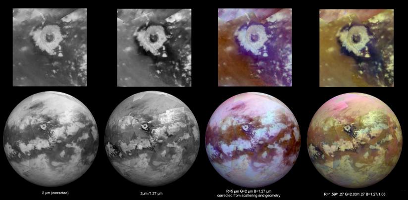 Link to page: http://photojournal.jpl.nasa.gov/catalog/PIA20022 |
|
|
|
|
Apr 1 2016, 02:43 AM
Post
#209
|
|
 Senior Member Group: Moderator Posts: 2785 Joined: 10-November 06 From: Pasadena, CA Member No.: 1345 |
Those are images, not maps. Maps are derived products from data such as this.
Just quibbling a bit.... -------------------- Some higher resolution images available at my photostream: http://www.flickr.com/photos/31678681@N07/
|
|
|
|
|
Apr 1 2016, 05:02 AM
Post
#210
|
|
|
Senior Member Group: Members Posts: 1583 Joined: 14-October 05 From: Vermont Member No.: 530 |
QUOTE (Juramike @ Mar 31 2016, 10:43 PM) Those are images, not maps. Maps are derived products from data such as this. Just quibbling a bit.... But they're composited -- what steps that up to a map? |
|
|
|
|

|
Lo-Fi Version | Time is now: 16th May 2024 - 04:07 PM |
|
RULES AND GUIDELINES Please read the Forum Rules and Guidelines before posting. IMAGE COPYRIGHT |
OPINIONS AND MODERATION Opinions expressed on UnmannedSpaceflight.com are those of the individual posters and do not necessarily reflect the opinions of UnmannedSpaceflight.com or The Planetary Society. The all-volunteer UnmannedSpaceflight.com moderation team is wholly independent of The Planetary Society. The Planetary Society has no influence over decisions made by the UnmannedSpaceflight.com moderators. |
SUPPORT THE FORUM Unmannedspaceflight.com is funded by the Planetary Society. Please consider supporting our work and many other projects by donating to the Society or becoming a member. |
|


